
Colleges
- American Athletic
- Atlantic Coast
- Big 12
- Big East
- Big Ten
- Colonial
- Conference USA
- Independents (FBS)
- Junior College
- Mountain West
- Northeast
- Pac-12
- Patriot League
- Pioneer League
- Southeastern
- Sun Belt
- Army
- Charlotte
- East Carolina
- Florida Atlantic
- Memphis
- Navy
- North Texas
- Rice
- South Florida
- Temple
- Tulane
- Tulsa
- UAB
- UTSA
- Boston College
- California
- Clemson
- Duke
- Florida State
- Georgia Tech
- Louisville
- Miami (FL)
- North Carolina
- North Carolina State
- Pittsburgh
- Southern Methodist
- Stanford
- Syracuse
- Virginia
- Virginia Tech
- Wake Forest
- Arizona
- Arizona State
- Baylor
- Brigham Young
- Cincinnati
- Colorado
- Houston
- Iowa State
- Kansas
- Kansas State
- Oklahoma State
- TCU
- Texas Tech
- UCF
- Utah
- West Virginia
- Illinois
- Indiana
- Iowa
- Maryland
- Michigan
- Michigan State
- Minnesota
- Nebraska
- Northwestern
- Ohio State
- Oregon
- Penn State
- Purdue
- Rutgers
- UCLA
- USC
- Washington
- Wisconsin
High Schools
- Illinois HS Sports
- Indiana HS Sports
- Iowa HS Sports
- Kansas HS Sports
- Michigan HS Sports
- Minnesota HS Sports
- Missouri HS Sports
- Nebraska HS Sports
- Oklahoma HS Sports
- Texas HS Hoops
- Texas HS Sports
- Wisconsin HS Sports
- Cincinnati HS Sports
- Delaware
- Maryland HS Sports
- New Jersey HS Hoops
- New Jersey HS Sports
- NYC HS Hoops
- Ohio HS Sports
- Pennsylvania HS Sports
- Virginia HS Sports
- West Virginia HS Sports
ADVERTISEMENT
You are using an out of date browser. It may not display this or other websites correctly.
You should upgrade or use an alternative browser.
You should upgrade or use an alternative browser.
OT: More chance of a 70F Christmas...Wintry Precip for NW sections Mon Night
- Thread starter RU848789
- Start date
Rain in the forecast for next 3 or 4 days. Showers on Christmas, so you may have some quality beach time.Whoo-hoo! Christmas on the beach at Manasquan. Bring the sunglasses and mistletoe...put the presents under the lifeguard stand and look for Santa to water ski in. It's a Merry Benny Christmas to us all !
at least we don't have to suffer through those unbearable threads about the possibility of it might snowing 10 days out
Yes and I see anxiety starting to creep in on the American Weather board.at least we don't have to suffer through those unbearable threads about the possibility of it might snowing 10 days out
What is the diffrence between holocaust deniers and 9/11 inside job people they are both delusional and denying facts. Science is made up of facts global warming and evolution are facts.You lose credibility when u lump those that are rightly sceptical of the science behind AGW and those that dont believe in evolution. Most that are in the former are not in the latter. Why not throw Holocaust deniars in there too or the crazies that think 9/11 was an inside job.

at least we don't have to suffer through those unbearable threads about the possibility of it might snowing 10 days out
Don't look now, but there's a chance we might finally get our first taste of winter Monday night. Luckily for me, it'll be several hours after we get back home from our 5 days in Vero Beach with family. Possibly a few inches of snow, especially north of I-78, but could even get an inch or so along I-95 before changing to sleet and then rain.
Still could bust completely and only be frozen well to the N/W (like the Poconos/Sussex/Catskills), but worth keeping an eye on. Almost certainly will be a decent snowfall (4-8" possible) north of about I-84, say from about Scranton to Hartford to Boston and points north of that line (and even 12" or more is possible north of I-90). Still 4 days out so not really worth its own thread yet. Maybe tomorrow...
usually the summers after El Nino are HOT..this year had some hot days but nothing crazy..next year could shape up as a classic hot summer based on analogs
true
Don't look now, but there's a chance we might finally get our first taste of winter Monday night. Luckily for me, it'll be several hours after we get back home from our 5 days in Vero Beach with family. Possibly a few inches of snow, especially north of I-78, but could even get an inch or so along I-95 before changing to sleet and then rain.
Still could bust completely and only be frozen well to the N/W (like the Poconos/Sussex/Catskills), but worth keeping an eye on. Almost certainly will be a decent snowfall (4-8" possible) north of about I-84, say from about Scranton to Hartford to Boston and points north of that line (and even 12" or more is possible north of I-90). Still 4 days out so not really worth its own thread yet. Maybe tomorrow...
lol way premature and I doubt this would deserve it own thread unless somehow these models come in colder...I mean this has the makings of a brief period of sleet to cold rain for a lot of the area with no accumulations..way too early in the game to be throwing out possible amounts
Last edited:
It hit 70 today in Boston.
I just went out to run an errand. Took two steps, turned around, dropped off my jacket, and ran my errand in a t-shirt and jeans.
I just went out to run an errand. Took two steps, turned around, dropped off my jacket, and ran my errand in a t-shirt and jeans.
Contrary to popular belief, weather exists in more areas than the east coast. It's cold out west, below normal.
In 1955, it was warmer across the country than it will be tomorrow.
In 1955, it was warmer across the country than it will be tomorrow.
In 1955, it was warmer across the country than it will be tomorrow.
Could you be more vague?
Could you be more vague?
What would you like, an hour by hour comparison in every major city?
To answer your silly question, yea, I could have been much more vague.
Weather History for KJFK - December, 1955
Sunday, December 25, 1955
Temperature
Mean Temperature 42 °F 35 °F
Max Temperature 50 °F 41 °F 58 °F (1982)
Min Temperature 35 °F 29 °F 2 °F (1983)
http://www.wunderground.com/history...statename=&reqdb.zip=&reqdb.magic=&reqdb.wmo=
Sunday, December 25, 1955
Temperature
Mean Temperature 42 °F 35 °F
Max Temperature 50 °F 41 °F 58 °F (1982)
Min Temperature 35 °F 29 °F 2 °F (1983)
http://www.wunderground.com/history...statename=&reqdb.zip=&reqdb.magic=&reqdb.wmo=
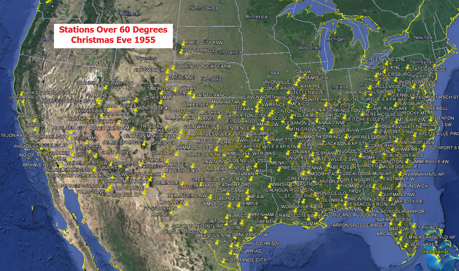
Why don't you just come out and make your point and include the link to the childish, very poorly written global climate change denying article this map is drawn from? Is it because you know the science is not behind you and you hope people just don't notice? Probably. Well the link to the crappy article from the website is below.
Just because there are ignorant people erroneously blaming our recent warm spell on global warming (it's mostly due to El Nino) doesn't mean that global warming isn't real. And, similarly, just because 1955 may have been (not convinced it was, but will concede both days were very warm) warmer, overall, than 2015 in the US on Christmas Eve, doesn't mean global warming isn't real. The moron at RealClimateScience has fallen prey to using the same flawed logic of confusing weather and climate.
http://realclimatescience.com/2015/12/christmas-eve-1955-was-much-warmer/
lol way premature and I doubt this would deserve it own thread unless somehow these models come in colder...I mean this has the makings of a brief period of sleet to cold rain for a lot of the area with no accumulations..way too early in the game to be throwing out possible amounts
Think you're going to be wrong on this one. Models trending a tad colder and both the NYC and Philly NWS offices are calling for at least a short period of accumulating snow/sleet late (i.e., maybe up to an inch - not a lot, but something in this crappy winter) Monday night, even along the I-95 corridor north of Trenton before a changeover to rain Tuesday morning as temps rise. And interior sections, i.e., from the Lehigh Valley to NW NJ (Sussex/Warren/Morris/W. Passaic/N. Bergen) to the Hudson Valley could be in for at least a moderate snowfall (2-5") before any changeover.
This isn't a "forecast" per se - just outlining the possibilities. Could definitely still be a complete bust with all rain for most of us, but a modest snowfall for most of us (i.e., within 20 miles of I-95) is also a possibility. Regardless of any accumulating snow, most locations near I-95 should be well above 32F by mid-morning on Tuesday, so travel impacts would be limited, unless one is well N/W. If the morning models continue to show this threat, will be time for a new thread. Below is the relevant thread on AmericanWx, as well as the latest snippets from the NWS discussions.
http://www.americanwx.com/bb/index.php/topic/47465-1229-1230-storm-potential/page-6
http://forecast.weat...1&highlight=off
THE STRONG HIGH WILL BE CENTERED OVER NEW ENGLAND...AND IN A GOOD POSITION FOR COLD AIR DAMMING TO SET UP AND SUPPLY COLD LOW LEVEL AIR TO THE REGION LATE MON NIGHT INTO TUE. MODEL GUIDANCE HAS CONTINUED TO TRENDED COLDER SURFACE AND ALOFT...WITH H7-8 TEMPS REMAINING BELOW 0C AT LEAST UNTIL AFTERNOON...WHEN STRONG S-SW FLOW AT H7-8 SHOULD BRING IN ENOUGH WARM AIR ALOFT. MOST AREAS SHOULD SEE A START AS SNOW...TRANSITIONING TO MIXED PCPN TUE MORNING BEFORE A CHANGE TO
RAIN BY TUE AFTERNOON AND INTO TUE NIGHT. IF THIS COLD TREND MAINTAINS...INTERIOR SECTIONS MAY HAVE POTENTIAL AT SEEING THE FIRST SIGNIFICANT SNOWFALL OF THE SEASON...WHILE AREAS JUST TO THE SOUTH...INCLUDING COASTAL CT TO JUST NW OF NYC...COULD HAVE A PD OF
ACCUMULATING SNOW BEFORE A CHANGE TO RAIN. EVEN SOME COASTAL AREAS
COULD SEE A BRIEF COATING OF SNOW/SLEET BEFORE WASHING AWAY.
CONTINUE TO HIGHLIGHT POTENTIAL FOR SIGNIFICANT SNOWFALL FOR INTERIOR SECTIONS ONLY ATTM.
http://forecast.weat...1&highlight=off
MONDAY NIGHT, THE HIGH TO OUR NORTH BUILDS OFFSHORE, AND THE
FRONTAL BOUNDARY TO OUR SOUTH BEGINS TO LIFT BACK NORTHWARD AS A
WARM FRONT. ALSO OVERNIGHT, A TRIPLE POINT LOW MAY BEGIN TO FORM
TO OUR SOUTH. OVERRRNNING PRECIPITATION IS EXPECTED TO DEVELOP
AND SPREAD NORTHWARD ACROSS THE AREA OVERNIGHT. THERE WILL BE COLD
AIR IN PLACE, SO IT LOOKS LIKE WE COULD HAVE SOME WINTRY
PRECIPITATION DEVELOP ACROSS PORTIONS OF THE AREA. GUIDANCE IS
INDICATING THE POTENTIAL FOR AN ACCUMULATION OF FREEZING RAIN,
SNOW, AND SLEET ACROSS THE NORTHERN TIER COUNTIES, WHILE THERE IS
THE POTENTIAL FOR A BRIEF PERIOD OF SNOW AND/OR SLEET EVEN AS FAR
SOUTH AS THE DELAWARE VALLEY BEFORE CHANGING OVER TO ALL RAIN.
Nam similar to Euro which was non event for us mainly as it trender warmer not colder so you are a bit behind with that. Sure there is a small chance we could see modest snowfall as you say but its small right now. Those further to the north in the usual sections in NJ could cash in on frozen but the most likely scenario as of now is maybe a brief period of snow or probably sleet quickly changing to rain. If it changes from that then we could go into snow mode not before
Snow totals here were just reported to be 24". Bing Crosby would be happy. I have to learn how to ski powder.
I'm not "behind" on anything. My post was made based on last night's model runs, which generally trended colder/snowier, except for the Euro and as you know the Euro doesn't really have much of an advantage in southwest flow events like this one (or even potential nor'easter blizzards, as we found out last year, when the Euro tanked on the "blizzard") - which is why the NWS is talking about some potential snow to start, even for the I-95 corridor.Nam similar to Euro which was non event for us mainly as it trender warmer not colder so you are a bit behind with that. Sure there is a small chance we could see modest snowfall as you say but its small right now. Those further to the north in the usual sections in NJ could cash in on frozen but the most likely scenario as of now is maybe a brief period of snow or probably sleet quickly changing to rain. If it changes from that then we could go into snow mode not before
Other than that, we largely agree - most likely mostly rain for the I-95 corridor and even nearby suburbs of NYC (with some snow/sleet to start) with snow amounts becoming significant for interior sections, i.e., N and W of 78/287, but especially N and W of 80/287. South of 195 is very likely to be all rain. But there are enough people on this forum that would get at least moderate snow that I'll likely start a thread on this if the 12Z (7 am EST initialized) model runs continue to show a decent threat.
dave - maybe update your profile, so we now where "here" is...Snow totals here were just reported to be 24". Bing Crosby would be happy. I have to learn how to ski powder.
Snow showers this morning in Sedona, AZ. Made a snowball from the dusting of snow on the hot tub cover.
Hey, all you Jim Cantores out there . . . heading to Boston/Foxboro for the Winter Classic over New Year's. Any prognostications (other than my Bruins probably losing to the Habs) re: the weather up there in the Dec. 30 - Jan 2 range? Many thanks for any insights.
Snow totals here were just reported to be 24". Bing Crosby would be happy. I have to learn how to ski powder.
You suck!

How much snow have you guys got so far? How's the total compared to the normal average and to last winter?
Yep, the models trended warmer - now very unlikely for much frozen precip except well inland, i.e., N and W of 287/80. But we're still 3+ days out, so still need to watch this one, although hopes for snow along 95 are fading...Lol check the Euro Numbers..don't need a thread
Yep, the models trended warmer - now very unlikely for much frozen precip except well inland, i.e., N and W of 287/80. But we're still 3+ days out, so still need to watch this one, although hopes for snow along 95 are fading...
Those with "hopes for snow" can kiss my snow-white arse.
This is my favorite winter so far.
Those with "hopes for snow" can kiss my snow-white arse.
This is my favorite winter so far.
+1

Game back on...only have a minute, so here's what I just read on the NWS discussion. Looks like mostly rain, still for the I-95 corridor, but likely to start as some sleet and maybe snow, especially as one nears 78. Could be some accumulation north of 78 and advisories might go up tomorrow for the interior suburbs N of 78, especially for freezing rain potential.
http://forecast.weather.gov/product...&format=CI&version=1&glossary=1&highlight=off
MONDAY NIGHT...A WINTER WX ADVISORY SITUATION APPEARS PROBABLE FOR A
PORTION OF REGION ALONG AND NORTH OF I-78, ESPECIALLY CARBON, MONROE
NORTHAMPTON COUNTIES IN PA AND SUSSEX, WARREN AND MORRIS COUNTIES
IN NORTHWEST NJ.
A WARM FRONT APPROACHES FROM THE SOUTH WITH RAIN EXCEPT MIXED
WINTRY PRECIPITATION NEAR AND NORTH OF I-78. THE THERMAL PROFILE
BETWEEN 850 AND 700MB (ESPECIALLY NEAR 775MB) WILL BE MARGINALLY
ABOVE FREEZING BUT VERTICAL VELOCITY AND WET BULBING MAY COOL THE
COLUMN ENOUGH TO PERMIT BETWEEN 1 AND 5 HOURS OF MOSTLY SNOW NEAR
AND NORTH OF ROUTE 80 CENTERED IN THE 02Z-09Z TIME FRAME, THEN A
CHANGE TO SLEET AND FREEZING RAIN AND EVENTUALLY ALL RAIN THERE
BETWEEN 11Z AND 15Z. FURTHER SOUTH NEAR I-78 INCLUDING BERKS, THE
LEHIGH VALLEY, WARREN HUNTERDON MORRIS AND SOMERSET. RAIN AND
SLEET TO START WITH POSSIBLY A TOUCH OF SNOW. FREEZING RAIN IS
POSSIBLE NEAR MIDNIGHT BEFORE IT WARMS ENOUGH TO ALL RAIN BY 11Z
TUESDAY.
PRECIPITATION MAY BE HEAVY FOR A TIME AFTER MIDNIGHT.
ITS FAR TOO EARLY TO CONFIDENTLY EXPRESS SNOW/GLAZE ACCUMULATIONS
BECAUSE OF THE PTYPE ISSUES ASSOCIATED WITH THE THERMAL PROFILE AND
TIMING DENDRITIC GROWTH WITH THE BRIEFLY FAVORABLE PORTION OF THIS
THERMAL PROFILE. FOR WHAT ITS WORTH, THE 12Z/26 ECMWF THERMAL
PROFILE LOOKS A BIT COLDER THAN THE 12Z/GFS/NAM 50 50 BLEND.
STRONGLY SUGGEST USING THE PROBABILISTIC SNOW GRIDS AVAILABLE ON OUR
WEB SITE, INCLUDING PROBABILITY OF GREATER THAN TRACE OF SNOW AND
10 PCT EXCEEDANCE.
PTYPE FM THICKNESS WAS FOUND AS EASIEST TO USE FOR THIS SITUATION
AND THE PARTIAL THICKNESS WAS A 50 50 BLEND OF THE 12Z GFS/NAM.
(WE ARE AWARE THE NAM WAS COLDER MONDAY NIGHT BECAUSE IT WAS
SLIGHTLY SLOWER).
Hold on Bac. Dan Zarrow 101.5 wrote a long piece on why NJ will get hit with snow/sleet/frz rain Monday night.
Similar threads
- Replies
- 87
- Views
- 4K
- Replies
- 74
- Views
- 2K
- Replies
- 59
- Views
- 3K
ADVERTISEMENT
ADVERTISEMENT