ADVERTISEMENT

Weather for Wagner @ RU: Looking warm (high in the mid/upper 60s) and likely dry, although low chance of a few light showers before noon

RU848789

Legend
Gold Member
Jul 27, 2001
60,561
39,143
113
Metuchen, NJ
Not a lock yet, but fairly high confidence in nice, warm weather, with highs around 70F, comfortable humidity, and no rain, after some unsettled weather with some showers Thursday/Friday and then high pressure taking control. However, the models are showing some lingering showers not far off the coast on Saturday, so given we're 6 days out, things could change and a few light showers (worst case) could be in play for Saturday. Need to see a few more model cycles before locking it up for a nice day.

https://www.weather.gov/phi/
 
Last edited:
  • Like
Reactions: BigEastPhil
yes, its waaaaaaaaaaaaaaaay too early for the thread title
"Looks like" or "looking" means pretty likely, but not a lock, which is exactly what we're looking at. It's still pretty likely that the day will be warm and dry, but there is still a slight chance we get a few light showers. Right now only one of the global models is showing any precip for our area on Saturday (and that would be a few light showers totaling about 0.1" between 7 am and 1 pm and zero after that) and the official NWS forecast has a <20% chance of rain for the entire day, which means a less than 20% chance "that more than 0.01 inches (0.25 mm) of precipitation will fall in a single spot, averaged over the forecast area." The latest NWS discussion looks good, as per below, which also indicates that it's quite possible the highs will be in the low/mid 70s. So yeah, it "looks like" a warm and dry day is pretty likely, but not a lock, as I said in my OP.

Area Forecast Discussion
National Weather Service Mount Holly NJ
703 AM EDT Mon Sep 25 2023

LONG TERM /THURSDAY THROUGH SUNDAY/...
By Saturday, that upper low will push quickly offshore. A rather
strong late-season ridge will expand and shift eastward from the
Plains across the Ohio and Tennessee Valleys through the weekend,
with broad surface high pressure drifting down the Appalachians.
Kept some slight chance POPs in on Saturday and down to the coast on
Sunday per NBM, but that looks aggressive as well. If the pattern
holds on the next model run or two, later shifts should probably
trend more optimistic. In fact, next weekend could turn out very
pleasant. We have highs in the forecast warming into the low to mid
70s, but warmer than that is a good possibility given then pattern,
and that may be accompanied by more sun than clouds as well.
 
Last edited:
  • Like
Reactions: rubigtimenow
  • Like
Reactions: Zak57
Still "looks" warm and dry for Saturday, but still not a lock for the dry part, since one of the 4 major global models (CMC) is still showing a few light showers up through the game, while the rest of the models show any precip being over well before the game. The NWS still has the low chances of showers over by about sunrise and only shows a slight (~15%) chance of light showers after that for the rest of the day, with mostly cloudy skies through early afternoon, then slowly increasing sunshine after that, with highs around 70F. Every other weather source I've looked at is also showing a warm and dry Saturday, after a showery Friday into early Saturday. Could be a bit breezy with 10-15 mph winds.
 
  • Like
Reactions: rubigtimenow
Still "looks" warm and dry for Saturday, but still not a lock for the dry part, since one of the 4 major global models (CMC) is still showing a few light showers up through the game, while the rest of the models show any precip being over well before the game. The NWS still has the low chances of showers over by about sunrise and only shows a slight (~15%) chance of light showers after that for the rest of the day, with mostly cloudy skies through early afternoon, then slowly increasing sunshine after that, with highs around 70F. Every other weather source I've looked at is also showing a warm and dry Saturday, after a showery Friday into early Saturday. Could be a bit breezy with 10-15 mph winds.
No real change in the forecast. Very likely warm (high around 70F) and comfortable (dewpoints near 60F) with a few showers through sunrise, but drying out after that with mostly cloudy skies through mid-afternoon and then increasing sunshing for the game. Still not a 100% lock for dry tailgates, as a couple of models show a stray, light shower or two (nuisance level, i.e., <0.02") up through early afternoon, but no models are showing measurable rain after that (although showers are just off the coast during that time and we're still 3 days out, so have to watch that).

The NWS official forecast doesn't mention rain, but the hourly graphic does have a slight chance (15%) of a light shower during the day and the discussion mentions the chance of a stray shower for the Shore during the day, which isn't that far from us.

.LONG TERM /SATURDAY THROUGH TUESDAY/...
Gradual return of high pressure building down from Canada will
be the theme for the long term, with a second high reinforcing
it from the northwest. After our nearly a week of clouds and at
least occasional rain, we appear to have a nice stretch of dry
and mostly sunny weather starting Sunday and continuing into at
least the middle of next week. Temps moderate as well with near
70 Saturday, mid 70s Sunday, and approaching 80 Monday thru
Wednesday. The low and associated front will remain close
enough Saturday to keep some clouds and perhaps a stray shower
around especially southern DE and near the NJ shore, but by
Sunday dry and increasingly weather sunny should prevail.
 
  • Love
Reactions: rubigtimenow
The thread title needs to be changed. Models are very wet Friday into Saturday. While showers could be out by kickoff they may impact tailgaters and despite what the thread title says its not going to be warm. Clouds will linger and unless we get late sun temps will hold in the cool 60s
 
  • Wow
Reactions: rubigtimenow
The thread title needs to be changed. Models are very wet Friday into Saturday. While showers could be out by kickoff they may impact tailgaters and despite what the thread title says its not going to be warm. Clouds will linger and unless we get late sun temps will hold in the cool 60s
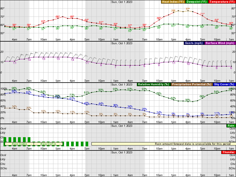
Showers are still very unlikely after about 9 am and any that falls after that will very likely be nuisance level as the NWS grid shows 0.01" from 8 am to 2 pm (which is essentially zip) and zero after that and no model shows more than 0.02" from 11 am through 7 pm, so I'm not going to put "rain" into the title. If we get a spritz, it'll be trivial. If we get more than 0.05" after about noon (an amount people will notice), you can lambaste me then, but I don't think we will and neither does the NWS or other sources. And the high will be 70F, which is warm to me, plus we should have some sun by mid afternoon and certainly for the game. It will be a bit breezy with 10-15 mph winds, so that might make it feel cool for some, but I think many will find it refreshing; I can add breezy to the title as that looks like a lock.

gOFlemg.png

Came here for exactly this this morning. Good news.
 
  • Like
Reactions: RU848789
Showers are still very unlikely after about 9 am and any that falls after that will very likely be nuisance level as the NWS grid shows 0.01" from 8 am to 2 pm (which is essentially zip) and zero after that and no model shows more than 0.02" from 11 am through 7 pm, so I'm not going to put "rain" into the title. If we get a spritz, it'll be trivial. If we get more than 0.05" after about noon (an amount people will notice), you can lambaste me then, but I don't think we will and neither does the NWS or other sources. And the high will be 70F, which is warm to me, plus we should have some sun by mid afternoon and certainly for the game. It will be a bit breezy with 10-15 mph winds, so that might make it feel cool for some, but I think many will find it refreshing; I can add breezy to the title as that looks like a lock.

gOFlemg.png

Summary: NWS forecast is for mild/warm temps (highs in upper 60s) and cloudy until gametime, when some sun is likely, with a low chance of a few very light showers (<0.05") before about 10-11 am and much less chance of any rain after that (maybe a brief sprinkle through early afternoon). With 2-3" of rain now likely thru Fri night, will be some puddles in low spots Sat morning (most areas just wet though).

Details: The NWS did increase the chance of a few light showers (~30% chance, totaling up to 0.03", which is a nuisance amount to me and most people) up through about noon, so early tailgaters might get a little bit of rain, although dry is a better bet, especially after about 9-10 am. After about noon, light shower chances drop off to ~20% and the amount of rain being forecast is near zero. However, it's worth noting that this morning's 6Z Euro, NAM, GFS and RDPS (Canadian version of the NAM) all show some light showers (<0.1") for early tailgaters up through about 10 am, but all show no rain at all after about 10 am and those models came out after the NWS forecast was made.

Will certainly be cloudy through at least early afternoon with mild to warm highs in the upper 60s and the forecast backed off on the winds a bit with ~10 mph winds forecast. Still thnk this will be great weather for tailgates (especially after 9-10 am with at most a few sprinkles possible up through about noon and even before that will still be ok, but maybe a canopy needed for a few showers) and especially the game, where we should start to see some sunshine and the chance of rain is very low - no model last night nor this morning has shown any rain at all after 1-2 pm. Will update the thread title, though, since the NWS forecast was a bit of a shift for more chance of light rain Saturday morning. It's also worth noting that all of the local TV forecasts I've seen show any rain over with by 9-10 am Saturday.

Finally one other comment. The NWS has greatly increased the rainfall forecasts for the rain to fall from tonight through Friday night, from 1/2" or so to now showing a widespread 1-3" with up to 4" possible towards the coast (2-3" forecast for P'way). With the ground already fairly saturated, this likely means that the tailgate lots will be wet through the morning (but drying out) and there could still be puddles in low spots (like the front of the yellow lot) by sunrise Saturday.

A few showers could still linger as we move into the daytime
hours of Saturday, especially along the coast, as our offshore
low takes its time moving away. Cloud coverage will likely
linger through much of the afternoon as well, though some areas
north and west could see clouds break and brief peeks of
sunshine before sunset during the evening. Afternoon highs will
be in the mid to upper 60s.

https://www.weather.gov/phi/
 
Last edited:
60s is not warm

The game itself should have no issues but its friggin Wagner. This is a game..homecoming that people are basically there for the tailgates...oops its not homecoming

The yellow and blue lots will be ugly..ground already saturated and another inch and possibly more will really worsen conditions

Even at best not the best for those morning tailgaters as conditions improve in the afternoon

Some models are showing alot of rain friday and friday night while others not as much...forecast not set in stone
 
Last edited:
60s is not warm

The game itself should have no issues but its friggin Wagner. This is a game..homecoming that people are basically there for the tailgates

The yellow and blue lots will be ugly..ground already saturated and another inch and possibly more will really worsen conditions

Even at best not the best for those morning tailgaters as conditions improve in the afternoon

Some models are showing alot of rain friday and friday night while others not as much...forecast not set in stone
Mid/upper 60s is warm to me, especially with some humidity and fairly light winds, but people can make their own judgments on that as they have the data.

Regardless, most people only care about falling rain and after about 10-11 am there shouldn't be more than a nuisance sprinkle or two (and even before 10-11 am, just a light shower or two is likely, not anything moderate to heavy), which I doubt even snowflakes will care about (and very unlikely for any sprinkles at all after 1-2 pm). It's much more likely it'll be completely dry after 10-11 am, especially if the latest 6Z models are all correct, which show no precip after that. Let's hope those 6Z models are correct.

Hard to predict drainage/puddles after a likely 2-3" of rain on top of fairly saturated ground (things have dried out somewhat though) through Friday night. My guess is low spots, like the front of the yellow and blue lots will have puddles and could get muddy. Later tailgaters at a bit of a hgher elevation should have wet ground but likely no puddles and I'm pretty sure those of us arriving at 12-1 pm will even have generally dry ground.
 
  • Like
Reactions: rubigtimenow
60s is not warm

The game itself should have no issues but its friggin Wagner. This is a game..homecoming that people are basically there for the tailgates

The yellow and blue lots will be ugly..ground already saturated and another inch and possibly more will really worsen conditions

Even at best not the best for those morning tailgaters as conditions improve in the afternoon

Some models are showing alot of rain friday and friday night while others not as much...forecast not set in stone
FYI: This game is not homecoming.
The MSU game is homecoming.
 
Oops..but why isnt it..doesn't it make more sense to get people to attend
Since we joined, the word has been that the B1G wants homecoming to always be a conference game.
No idea why that would be imprtant to the conference, but there it is.
I agree that it would be better for several reasons to make our FCS game himecoming.
 
With 3+ inches of rain in the next 36 - 48 hours cause any flooding around the stadium? The NWS has a Flood Watch thru Fri Night.
 
I think there may be higher rain totals toward the coast.
Yeah we've had coastal flood advisories since Friday continuing thru this coming weekend. Monday and Tuesday were the greatest flooding in the usual places. I was referring to this morning's NWS forecast tonight thru Fri Nite for NB and P'way.
 
Just saw the most recent forecasts which shift higher totals west. Connecticut gets hammered with some projections.
 
  • Like
Reactions: knightfan7
60s is not warm

The game itself should have no issues but its friggin Wagner. This is a game..homecoming that people are basically there for the tailgates...oops its not homecoming

The yellow and blue lots will be ugly..ground already saturated and another inch and possibly more will really worsen conditions

Even at best not the best for those morning tailgaters as conditions improve in the afternoon

Some models are showing alot of rain friday and friday night while others not as much...forecast not set in stone
Upper 60's and sun is kinda warm to most of us...com'on...that's t-shirt and cargo weather! Granted, NOT "tuxedo" weather lol!
 
60s is not warm

The game itself should have no issues but its friggin Wagner. This is a game..homecoming that people are basically there for the tailgates...oops its not homecoming

The yellow and blue lots will be ugly..ground already saturated and another inch and possibly more will really worsen conditions

Even at best not the best for those morning tailgaters as conditions improve in the afternoon

Some models are showing alot of rain friday and friday night while others not as much...forecast not set in stone
Maybe if you increased your body fat % a bit you wouldn't feel the cold as much lol.

No huh?
 
  • Wow
Reactions: AreYouNUTS
Since we joined, the word has been that the B1G wants homecoming to always be a conference game.
No idea why that would be important to the conference, but there it is.
I agree that it would be better for several reasons to make our FCS game homecoming.
That's not exactly true. Northwestern, Penn State, Minnesota all play non conference games this year.
Rutgers does play in 4 Homecoming games this year. Our own against Michigan State at noon.
Rutgers is the homecoming foe at Michigan, at Wisconsin and at Indiana
 
  • Like
Reactions: Plum Street
ADVERTISEMENT
ADVERTISEMENT