ADVERTISEMENT

OT: Major Nor'easter for our region Thursday into Friday (12/16/22) - looks mostly wet for most of us

@RU848789 Going skiing to Hunter Friday AM. Lee Goldberg has 6-12" for the northern Catskills. What are the odds I have issue driving up before 7 AM Friday?
I was just going to ask what Hunter is looking at with this storm.

I'll look to get up there after the storm though.
 
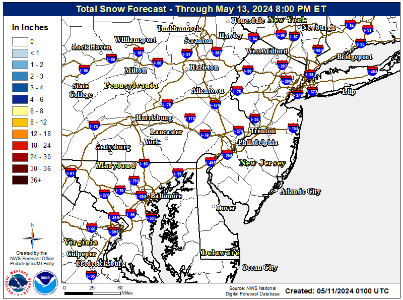
No, no chance - it's gonna be a pretty serious rain/wind storm for most of the area with 1-2" of rain and wind advisories likely for the coast, at least (and possibly some minor coastal flooding, although we'll have astronomical lower tides than normal, which will minimize that). Will likely only see more than 1-2" of snow/sleet in the Poconos and the Catskills (with 4-8" in the Poconos and 8-16" in the Catskills).

Even Sussex County is only forecast to get 1-2" on the front end through Thursday evening and other areas well NW of 95, like the Lehigh Valley, Warren, Morris, W. Passaic, etc, might get up to 1" of snow/sleet during the day on Thursday, so the Thursday pm commute could be tough in those NW areas before the changeover to all rain, probably by late afternoon/early evening.

For areas near the 95 corridor (even 10-20 miles NW of there), any snow/sleet will likely be short-lived during the late morning (early morning down by Philly) with maybe a coating to 1/2" possible before the warm air changes things over to rain for everyone near 95 (and the coast should be all rain).

One caveat to all this: the NWS snowfall forecast is on the low side relative to what the models are showing, as most of the models are showing 2-4"/3-6" for places like the Lehigh Valley, Sussex/Warren, NW Morris and NW Passaic (and the Hudson Valley N of the Tappan Zee) and even 1-3" for places like western Hunterdon and northern Somerset vs. the 1-2" or less forecast by the NWS, so there is the potential for this system to overperform. See the NBM (National Model Blend) based on the 12Z models today, which is the same thing the NWS forecasts were evaluating when they put out there snowfall forecast.

PHI_Snow.png


snowfall_acc.us_ma.png

NWS still has watches up for Carbon/Monroe (Poconos) for 3-7" of snow/sleet, then some freezing rain and then rain, but has added advisories for the Lehigh Valley (Lehigh/Northampton), Sussex and Warren for 1-3" of snow/sleet on Thursday before the changeover to freezing rain (up to 0.1" possible) and then rain Thursday evening. All of these areas will likely have slushy/icy roads for Thursday afternoon/evening. Will also likely see an inch or so of snow/sleet and a little freezing rain in NW Morris, NW Passaic and the Hudson Valley (west of the Hudson), even though these areas don't have advisories (yet).

Interestingly, the NWS also has advisories up for all of the counties in DE, SEPA, and SNJ along the Delaware River from Wilmington up to Trenton, because the precip is moving in there earlier (after sunrise Thursday), while it's still below 32F, meaning precip for the morning rush time will likely be some (<1/2") snow/sleet and maybe a touch of freezing rain, before the precip is all rain by late morning. This advisory has a good chance of not verifying, as it's mostly based on the risk of maybe 0.01-0.02" of ice.

I'll be surprised if anyone along the 95 corridor from Wilmington to NYC sees much wintry precip - looks more like a rain event with 1.5-2.5" of heavy rain on tap - and absolutely all rain SE of 95. This is enough rain for localized urban flooding, but probably not for stream/river flooding (we're still at a rain deficit). For the coast, we might still see a wind advisory, as gusts to 45 mph are already forecast; tidal flooding should be minor, at most, and maybe won't occur at all. Would need a major shift in the storm track (offshore for the coastal), plus more cold air for even minor (1-2") or moderate (2-4") snowfall for the 95 corridor - looking very unlikely.

The big snows (8-16", depending on elevation) will likely be found in the Catskills, Adirondacks and much of interior New England and New York, especially at the higher elevations, which is good news for the ski resorts. FYI, there's also an ice storm warning for much of western MD/VA and eastern WV for 1/4-1/2" of freezing rain ice accretion - nasty stuff.

The 12Z NAM and GFS did just come in a lot colder than previous runs with about 1" along 78, 1-3" along 80 and 3-7" for the Poconos, Sussex, and the Hudson Valley, so there is still the potential for this storm to be more wintry, especially not far NW of 95 and N of 78. Included the updated NWS snowfall map from 7 am this morning and the 6Z (1 am EST) model blend map of snowfall (which would've been a major input for the NWS map); the models are still a little snowier than the NWS.

https://www.weather.gov/phi/

https://www.33andrain.com/topic/2122-december-15-17th-mid-atlantic-new-england-storm-threat/page/20/

b8UDmCo.png


StGvAep.png
 
Thanks! Would be leaving from NW Bergen county and would be on the road around 6 AM. If the forecast is 10-16", even I may have to pass on that. Snow doesn't scare me since I have an AWD vehicle, but that mountain pass on 23A may be challenging with that much snow.
My guess is you'll be fine on the interstate and state roads from Bergen to near Hunter, but sounds like you know more about the local roads up to Hunter than I do - but wouldn't they keep those pretty clear even in the midst of a snowstorm? The NWS did up snowfall amounts for the Hudson Valley, i.e., the ride up 87, vs. last night with 2-4" being forecast, but I would think it would be raining by 6 am and that snow would've been cleared along 87 by then.

VwDp7ef.png
 
Last edited:
My guess is you'll be fine on the interstate and state roads from Bergen to near Hunter, but sounds like you know more about the local roads up to Hunter than I do - but wouldn't they keep those pretty clear even in the midst of a snowstorm? The NWS did up snowfall amounts for the Hudson Valley, i.e., the ride up 87, vs. last night with 2-4" being forecast, but I would think it would be raining by 6 am and that snow would've been cleared along 87 by then.

StormTotalSnow.jpg
Thanks. That map is interesting since it's a narrow band to go from essentially no snow on 87 to 12-18" 20 miles west. 87 looks fine and I have done up to 6" with no issues. 23A however is single lane through the mountain pass and at one point slows to 15 MPH for a hairpin turn. They do clean it well but there is not much clearance if there is an accident (no shoulders). Plus with heavy snow during the day may make it more difficult to park/ski. We get the heavy stuff and not the powder like out west. That being said I am sure I will still be a go. 😀
 
  • Like
Reactions: RU848789
Thanks. That map is interesting since it's a narrow band to go from essentially no snow on 87 to 12-18" 20 miles west. 87 looks fine and I have done up to 6" with no issues. 23A however is single lane through the mountain pass and at one point slows to 15 MPH for a hairpin turn. They do clean it well but there is not much clearance if there is an accident (no shoulders). Plus with heavy snow during the day may make it more difficult to park/ski. We get the heavy stuff and not the powder like out west. That being said I am sure I will still be a go. 😀
Sorry, the map I pasted an hour ago was from yesterday (an issue if I don't save maps to imgur). I just updated it and it now matches what I wrote above, i.e., even on 87 they're now expecting 1-3" of snow north of about 84 tomorrow night, although I would expect that to be well plowed, plus it still should change to rain well before sunrise, so 87 ought to be just wet after sunrise. But yes, the snowfall gradient from 87 to Hunter along 23A will be very steep.
 
  • Like
Reactions: Section124
Chances of my United flight landing In Newark at 9pm Thursday? (Outside of normal Newark and united challenges).
 
Are we supposed to get snow in South Hunterdon county now?
Look it up:
weather.com

Perhaps a nuisance/mood flake or two, but it will be well into the 40s for our entire area later today (and overnight).
 
Are we supposed to get snow in South Hunterdon county now?

This morning the snow line moved a little north. Catskills are going to get 6-12. NW New Jersey may see snow but nowhere near those amounts.
 
  • Like
Reactions: Zak57
Is there a forecast in inches for NJ rain?
Widespread 1-2" of rain for everyone in NJ (and SEPA/NYC/LI) except far NWNJ, where several inches of snow/sleet will fall before the changeover to rain tonight.

The only major question left is whether Sussex (and maybe the higher elevations in Warren and NW Morris and NW Passaic) are going to get the 1-3" of snow/sleet currently forecast by the NWS or the 3-5" forecast by many other mets (like Lee Goldberg)...or the 6-10" shown in about half of the models. The Poconos are forecast to get 3-7" by the NWS and 6-9" by many. The Catskills and interior New York/New England, at least in the ski resorts are still forecast to get 8-16".

The next chance for wintry weather is next Thursday night through Friday. Way too far off for any forecast, but people are going to start seeing this popping up on social media any minute now given the potential "White Christmas" angle. Unlike today's system, which always looked like mostly rain for 95 and inland snow to rain, next week's system looks potentially snowy for everyone on the Euro and Canadian, but is a miss on the GFS.

FR1p5Dw.png
 
  • Like
Reactions: RU#1fan
Are we supposed to get snow in South Hunterdon county now?
For cities in Hunterdon, NJ County
>=0.1"​
>=1"​
>=2"​
>=4"​
>=6"​
>=8"​
>=12"​
>=18"​
Location​
Snow Amount Potential​
Flemington, NJ​
0​
0​
<1​
18%​
0%​
0%​
0%​
0%​
0%​
0%​
0%​
Lambertville, NJ​
0​
<1​
<1​
32%​
0%​
0%​
0%​
0%​
0%​
0%​
0%​
High Bridge, NJ​
0​
<1​
<1​
33%​
2%​
0%​
0%​
0%​
0%​
0%​
0%​
Clinton, NJ​
0​
<1​
<1​
33%​
1%​
0%​
0%​
0%​
0%​
0%​
0%​


For cities in Mercer, NJ County
>=0.1"​
>=1"​
>=2"​
>=4"​
>=6"​
>=8"​
>=12"​
>=18"​
Location​
Snow Amount Potential​
Trenton, NJ​
0​
<1​
<1​
15%​
0%​
0%​
0%​
0%​
0%​
0%​
0%​
Princeton, NJ​
0​
0​
0​
0%​
0%​
0%​
0%​
0%​
0%​
0%​
0%​
Hightstown, NJ​
0​
0​
0​
0%​
0%​
0%​
0%​
0%​
0%​
0%​
0%​
Pennington, NJ​
0​
<1​
<1​
15%​
0%​
0%​
0%​
0%​
0%​
0%​
0%​
 
Been raining down here in VA since 8 last night, still fairly heavy as of now. Would have been a boatload of snow if it was colder.
 
We started as sleet here in the Edison/Metuchen area around noon and got a tiny coating before the quick changeover to rain. That's it until late next week for us. Good luck to all of you hoping for snow, well NW of here and especially in the ski resorts. Still interested to see if the models are correct or the NWS, which has consistently forecast less snow than most of the models for the far NW areas (Sussex/Warren/Poconos/Hudson Valley).
 
Widespread 1-2" of rain for everyone in NJ (and SEPA/NYC/LI) except far NWNJ, where several inches of snow/sleet will fall before the changeover to rain tonight.

The only major question left is whether Sussex (and maybe the higher elevations in Warren and NW Morris and NW Passaic) are going to get the 1-3" of snow/sleet currently forecast by the NWS or the 3-5" forecast by many other mets (like Lee Goldberg)...or the 6-10" shown in about half of the models. The Poconos are forecast to get 3-7" by the NWS and 6-9" by many. The Catskills and interior New York/New England, at least in the ski resorts are still forecast to get 8-16".

The next chance for wintry weather is next Thursday night through Friday. Way too far off for any forecast, but people are going to start seeing this popping up on social media any minute now given the potential "White Christmas" angle. Unlike today's system, which always looked like mostly rain for 95 and inland snow to rain, next week's system looks potentially snowy for everyone on the Euro and Canadian, but is a miss on the GFS.

FR1p5Dw.png

Looks like the snow has and will overperform for the NW areas, as per most of the models. Reports of 1-2" in the Lehigh Valley, Warren, most of Morris, NW Passaic, N Bergen and parts of the Hudson Valley and in most of these locations the snow/sleet have changed to rain or will shortly. Most of NW Warren, Sussex County, the Poconos (Carbon/Monroe) and the Hudson Valley well west of 87 are where it's been all snow with 2-5" in most places.

Another 1-2" likely is for most of Sussex and NW Warren before becoming all rain after midnight or so, and the Poconos might get another 3-6" with some of the higher elevations never changing to rain. The Catskills and the ski resorts in interior New England are on tap to get 10-20" of snow, which is great for them.

Lots of rain for everyone else with 1-2" falling overall for most. The wind advisory is still in place for gusts to 45 mph near and along the coast, while a coastal flood advisory was posted for the NJ coast for, at most, minor tidal flooding in the usual most vulnerable locations.
 
Lots of rain for everyone else with 1-2" falling overall for most. The wind advisory is still in place for gusts to 45 mph near and along the coast, while a coastal flood advisory was posted for the NJ coast for, at most, minor tidal flooding in the usual most vulnerable locations.
I brought in the flags at mine and my Parent's house in anticipation of this.
 
Looks like the snow has and will overperform for the NW areas, as per most of the models. Reports of 1-2" in the Lehigh Valley, Warren, most of Morris, NW Passaic, N Bergen and parts of the Hudson Valley and in most of these locations the snow/sleet have changed to rain or will shortly. Most of NW Warren, Sussex County, the Poconos (Carbon/Monroe) and the Hudson Valley well west of 87 are where it's been all snow with 2-5" in most places.

Another 1-2" likely is for most of Sussex and NW Warren before becoming all rain after midnight or so, and the Poconos might get another 3-6" with some of the higher elevations never changing to rain. The Catskills and the ski resorts in interior New England are on tap to get 10-20" of snow, which is great for them.

Lots of rain for everyone else with 1-2" falling overall for most. The wind advisory is still in place for gusts to 45 mph near and along the coast, while a coastal flood advisory was posted for the NJ coast for, at most, minor tidal flooding in the usual most vulnerable locations.

Still no snow in Bergen yet.
 
Will this a be a “named” thing?
Do you mean by the Weather Channel? If so, I'm sure it will be, as long as it doesn't completely fizzle (still possible, but moving towards unlikely) - and I would certainly start a new thread on it if it's still looking threatening about 5 days out (by Sunday or so)...
 
ADVERTISEMENT

Latest posts

ADVERTISEMENT