I'm sure there must be some support groups out there for you. :stuck_out_tongue_winking_eye:Quick update - everything is trending snowier in the models. I could leave it at that with some maps, but I can't, lol.
ADVERTISEMENT
You are using an out of date browser. It may not display this or other websites correctly.
You should upgrade or use an alternative browser.
You should upgrade or use an alternative browser.
Snow 1/3-1/4? And continued very cold...
- Thread starter RU848789
- Start date
- Status
- Not open for further replies.
Huh?
Kudos to #s for saying a week ago “more likely than not this storm is hitting” (or something similar). Took a lot of heat, but it turned out to be correct. Weather is crazy.
What mikemarc1 said. You should be serving up crow to all those that gave you crap, especially the Annie Lennox lover. The bac and forth was funny, but someone owes you an apology.
Massive Blizzard to Hit New Brunswick on Thursday January 4, 2018
I always wondered what you looked like. Finally.
I always wondered what you looked like. Finally.
Wrong yet again...
Thx Numbers, when is the next model run you are waiting for to come out? Might have to change some plans for tomorrow for me and the wife.
Most run 4X per day at 0, 6, 12, and 18Z (which is the t=0 initialization time in Greenwich Mean Time, so 12Z is 7 am EST), but we don't get the ouput for 3-6 hours depending on the model (lots of calcs). However, the Euro only runs at 0 and 12Z (same for the UK and Canadian, I think), so the 0Z and 12Z suites are the only ones where every model runs. The 18Z partial suite will be out around 4-6 pm and the 0Z suite will be out about 10 pm to 1 am tonight.
Also, we're getting very close to the event, so the short-range, high resolution models start to become more accurate vs. the global models. I'm expecting to see much more consensus by 0Z tonight (7 pm data input), which is about 6-8 hours before the precip starts around here - we already saw a major move towards consensus with the global models getting much snowier and the meso models getting a bit less snow (but not all).
If I posted all the model snowfall maps, I think everyone would say it's just nuts to look at - that's why I prefer posting the NWS forecast maps, since they're way better at this than anyone around here or most of the on-line folks and they weigh all the models appropriately or at least try to. But they can be quite wrong, too. Tough science to get right.
What mikemarc1 said. You should be serving up crow to all those that gave you crap, especially the Annie Lennox lover. The bac and forth was funny, but someone owes you an apology.
lol...you have to be kidding me. The models changed about 1000x between then and today, even as late as last night the Euro was showing 1-2 inches. He didnt score some kind of coup by saying its likely to have a 6 inch plus storm 8 days out. Its was never about right or wrong. I said he could be right...it was all about making a statement like that 8 days away when you know the models are going to change. In fact it was the Euro showing this bomb and then it took it away next run and continued to be way east until today...so lets be real here. No one...I mean no one knew what was going to happen including every met out there
not sure why people want dredge that controversy up again
When is this thing starting?
sometime after midnight...main show is 6AM-2PM
What mikemarc1 said. You should be serving up crow to all those that gave you crap, especially the Annie Lennox lover. The bac and forth was funny, but someone owes you an apology.
Actually, he had some valid points, as I rarely make statements like that that far out and it was probably questionable, but I will say it's nice to see my way of thinking likely verifying (but it ain't over till the ruler is in the snow and this could still largely miss). My bigger beef, by far, with him and others is they think I hype events and I absolutely do not think so, but I can't "make" people see what I see - learned that a long time ago, lol.
..... (but it ain't over till the ruler is in the snow ...). .....
Wait, I thought it was based off of the quantity of french toast made!
This board loves controversy.lol...you have to be kidding me. The models changed about 1000x between then and today, even as late as last night the Euro was showing 1-2 inches. He didnt score some kind of coup by saying its likely to have a 6 inch plus storm 8 days out. Its was never about right or wrong. I said he could be right...it was all about making a statement like that 8 days away when you know the models are going to change. In fact it was the Euro showing this bomb and then it took it away next run and continued to be way east until today...so lets be real here. No one...I mean no one knew what was going to happen including every met out there
not sure why people want dredge that controversy up again
Sorry.
But your post reminded me of:
You may be right
I may be crazy
But it just may be a lunatic you're looking for
Turn out the light
Don't try to save me
You may be wrong for all I know
But you may be right
the best part of the weather threads is when a consensus on a storm starts to be reached everybody comes together, gets serious and delivers facts. So kudos to #s and to me as well lol. We have our biases in our own way leading up to a storm but in crunch time I think the biases are put aside and we are honest with everyone.
Fingers crossed none of this affects a Friday morning flight out of LGA
well its going to be bitter cold and there is a greater liklihood of more snow there than say Newark so going to be dicey. Snow should be over in the late afternoon so they will have some time
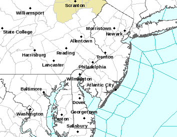
Boom - winter storm warnings (pink) and blizzard warnings (orange) now up for I-95 counties and coastal counties in NJ/LI, respectively, as well as winter weather advisories (blue). And snowfall amounts up again as per maps. Strap in folks.


Last edited:
What do the colors mean?Boom - winter storm warnings and blizzard warnings now up...

added into post above...What do the colors mean?
No warning for my county! :)Boom - winter storm warnings (pink) and blizzard warnings (orange) now up for I-95 counties and coastal counties in NJ/LI, respectively, as well as winter weather advisories (blue). And snowfall amounts up again as per maps. Strap in folks.


Non-event!No warning for my county! :)
No warning for my county! :)
Somerset is on the borderline to getting the heaviest snows...looks like that axis will set up along 95...Philly to Trenton to Brunswick to Newark to NYC...everything east of there looks to be the best snows and potentially large amounts...to the east of that its going to be lesser tapering the further northwest you go
Here is the 12K NAM that just came in...you can see the sharp gradient...a shift in either direction would make for huge changes. So it is possible that Somerset and Hunterdon could get in on the bigger snows but based on all the modeling right now they all seem to show a distinct cutoff around 195. This NAM run verbatim did cut totals to the NW of 95 while increasing and increasing the gradient SE of 95

below is the hi resolution 3K NAM output
this slightly shifts amounts up to I78 that the 12K Nam didnt

9-10" at the shore? "Down the shore, everything is all right. . ." :sunglasses:Boom - winter storm warnings (pink) and blizzard warnings (orange) now up for I-95 counties and coastal counties in NJ/LI, respectively, as well as winter weather advisories (blue). And snowfall amounts up again as per maps. Strap in folks.


Decision Support Briefing # 3 As of: 400 PM Wednesday, January 3
What Has Changed?
Blizzard warning now in effect for coastal locations
Expected snowfall totals have increased.
Several adjustments to winter storm warnings and winter weather advisories
Increased threat of coastal flooding
http://www.weather.gov/media/phi/current_briefing.pdf
What Has Changed?
Blizzard warning now in effect for coastal locations
Expected snowfall totals have increased.
Several adjustments to winter storm warnings and winter weather advisories
Increased threat of coastal flooding
http://www.weather.gov/media/phi/current_briefing.pdf
2-4 to the NW of 95...I think there is potential for these amounts to go a bit higher but I think still a solid call...these areas are in a Winter Weather Adivisory and not a watch
URGENT - WINTER WEATHER MESSAGE
National Weather Service Mount Holly NJ
317 PM EST Wed Jan 3 2018
...High Impact Storm including the aftermath of wind driven
record cold on its way to our area...
...A rapidly intensifying coastal storm will produce significant
snowfall and strong winds tonight through Thursday...
NJZ001-007>010-PAZ060>062-101-103-105-041000-
/O.EXA.KPHI.WW.Y.0001.180104T0200Z-180105T0000Z/
Sussex-Warren-Morris-Hunterdon-Somerset-Berks-Lehigh-Northampton-
Western Chester-Western Montgomery-Upper Bucks-
Including the cities of Newton, Washington, Morristown,
Flemington, Somerville, Reading, Allentown, Bethlehem, Easton,
Honey Brook, Oxford, Collegeville, Pottstown, Chalfont,
and Perkasie
317 PM EST Wed Jan 3 2018
...WINTER WEATHER ADVISORY IN EFFECT FROM 9 PM THIS EVENING TO
7 PM EST THURSDAY...
* WHAT...Snow and blowing snow expected. Plan on slippery road
conditions, including during the morning commute on Thursday.
In addition, areas of poor visibility are expected. Total snow
accumulations of 2 to 4 inches are expected.
* WHERE...Portions of northern and northwest New Jersey and east
central and southeast Pennsylvania.
* WHEN...From 9 PM this evening to 7 PM EST Thursday.
* ADDITIONAL DETAILS...Winds gusting as high as 40 mph will cause
areas of blowing and drifting snow. Scattered power outages
could develop Thursday and Friday which would force considerable
hardship where heat would not be available.
PRECAUTIONARY/PREPAREDNESS ACTIONS...
A Winter Weather Advisory for snow and blowing snow means periods
of snow and blowing snow will cause primarily travel
difficulties. Be prepared for snow covered roads and limited
visibilities, and use caution while driving. The latest road
conditions for the state you are calling from can be obtained by
calling 5 1 1.
DPW is planning for 3-6 inches, likely enough for no school or township meetings in the evening!Somerset is on the borderline to getting the heaviest snows...looks like that axis will set up along 95...Philly to Trenton to Brunswick to Newark to NYC...everything east of there looks to be the best snows and potentially large amounts...to the east of that its going to be lesser tapering the further northwest you go
Here is the 12K NAM that just came in...you can see the sharp gradient...a shift in either direction would make for huge changes. So it is possible that Somerset and Hunterdon could get in on the bigger snows but based on all the modeling right now they all seem to show a distinct cutoff around 195. This NAM run verbatim did cut totals to the NW of 95 while increasing and increasing the gradient SE of 95

below is the hi resolution 3K NAM output
this slightly shifts amounts up to I78 that the 12K Nam didnt

yes thats my thinking too..modeling does show more in the southeastern parts of somerset. Would love 2-4 but preparing for 4-6 here which isnt bad, just keep all that other crap east of New Brunswick
URGENT - WINTER WEATHER MESSAGE
National Weather Service Mount Holly NJ
317 PM EST Wed Jan 3 2018
...High Impact Storm including the aftermath of wind driven
record cold on its way to our area...
...A rapidly intensifying coastal storm will produce significant
snowfall and strong winds tonight through Thursday...
NJZ012-015>019-PAZ070-071-104-106-041000-
/O.UPG.KPHI.WW.Y.0001.180104T0200Z-180105T0000Z/
/O.EXA.KPHI.WS.W.0001.180104T0200Z-180105T0000Z/
Middlesex-Mercer-Salem-Gloucester-Camden-Northwestern Burlington-
Delaware-Philadelphia-Eastern Montgomery-Lower Bucks-
Including the cities of New Brunswick, Trenton, Pennsville,
Glassboro, Camden, Cherry Hill, Moorestown, Mount Holly, Media,
Philadelphia, Norristown, Lansdale, Morrisville, and Doylestown
317 PM EST Wed Jan 3 2018
...WINTER STORM WARNING IN EFFECT FROM 9 PM THIS EVENING TO 7 PM
EST THURSDAY...
* WHAT...Heavy snow and blowing snow expected. Plan on difficult
travel conditions, including during the morning commute on
Thursday. Tree branches could fall as well. Total snow
accumulations of 5 to 7 inches are expected.
* WHERE...Portions of central, northern and southern New Jersey
and southeast Pennsylvania.
* WHEN...From 9 PM this evening to 7 PM EST Thursday.
* ADDITIONAL DETAILS...Winds gusting as high as 45 mph will cause
areas of blowing and drifting snow. Scattered power outages
could develop Thursday and Friday which would force considerable
hardship where heat would not be available.
PRECAUTIONARY/PREPAREDNESS ACTIONS...
A Winter Storm Warning for snow and blowing snow means severe
winter weather conditions are expected. If you must travel, keep
an extra flashlight, food and water in your vehicle in case of an
emergency. The latest road conditions for the state you are
calling from can be obtained by calling 5 1 1.
RGENT - WINTER WEATHER MESSAGE
National Weather Service New York NY
320 PM EST Wed Jan 3 2018
NJZ002-004-103>105-107-NYZ067>070-040430-
/O.NEW.KOKX.WW.Y.0001.180104T0600Z-180105T0600Z/
Western Passaic-Eastern Passaic-Western Bergen-Eastern Bergen-
Western Essex-Western Union-Orange-Putnam-Rockland-
Northern Westchester-
320 PM EST Wed Jan 3 2018
...WINTER WEATHER ADVISORY IN EFFECT FROM 1 AM THURSDAY TO 1 AM
EST FRIDAY...
* WHAT...Snow and blowing snow expected. Plan on slippery road
conditions, including during the morning commute on Thursday.
In addition, areas of poor visibility are expected. Total snow
accumulations of 2 to 5 inches are expected.
* WHERE...Portions of northeast New Jersey and southeast New
York.
* WHEN...From 1 AM Thursday to 1 AM EST Friday.
* ADDITIONAL DETAILS...Winds gusting as high as 40 mph will
cause areas of blowing and drifting snow.
PRECAUTIONARY/PREPAREDNESS ACTIONS...
A Winter Weather Advisory for snow and blowing snow means periods
of snow and blowing snow will cause primarily travel
difficulties. Be prepared for snow covered roads and limited
visibilities, and use caution while driving. The latest road
conditions for the state you are calling from can be obtained by
calling 5 1 1.
RGEM which is a short term model coming in a bit drier...its more in line with GFS/Euro/GGEM with amounts.....3-6 central jersey, 2-4 north...6-10 south jersey and coast. The NAM is clearly the outlier with the heavier snowfall totals...now all the other models have move toward the NAM but that does not mean they will move further toward the NAM..maybe a leveling out period where models start to sit tight...GFS up next.
I live in eastern Monmouth county. Inlaws have a generator and are in western Union county. I have a 5 month old. My wife wants to leave tonight to inlaws (who have a generator), She's concerned about wind related power outages and no heat.... what's the move?
I obviously want to stay put...
I obviously want to stay put...
- Status
- Not open for further replies.
Similar threads
- Replies
- 18
- Views
- 790
- Replies
- 39
- Views
- 2K
- Replies
- 62
- Views
- 3K
- Replies
- 26
- Views
- 722
ADVERTISEMENT
ADVERTISEMENT


