ADVERTISEMENT

OT: Now-Hurricane Idalia to Hit Florida Big Bend as a Major Hurricane Weds am

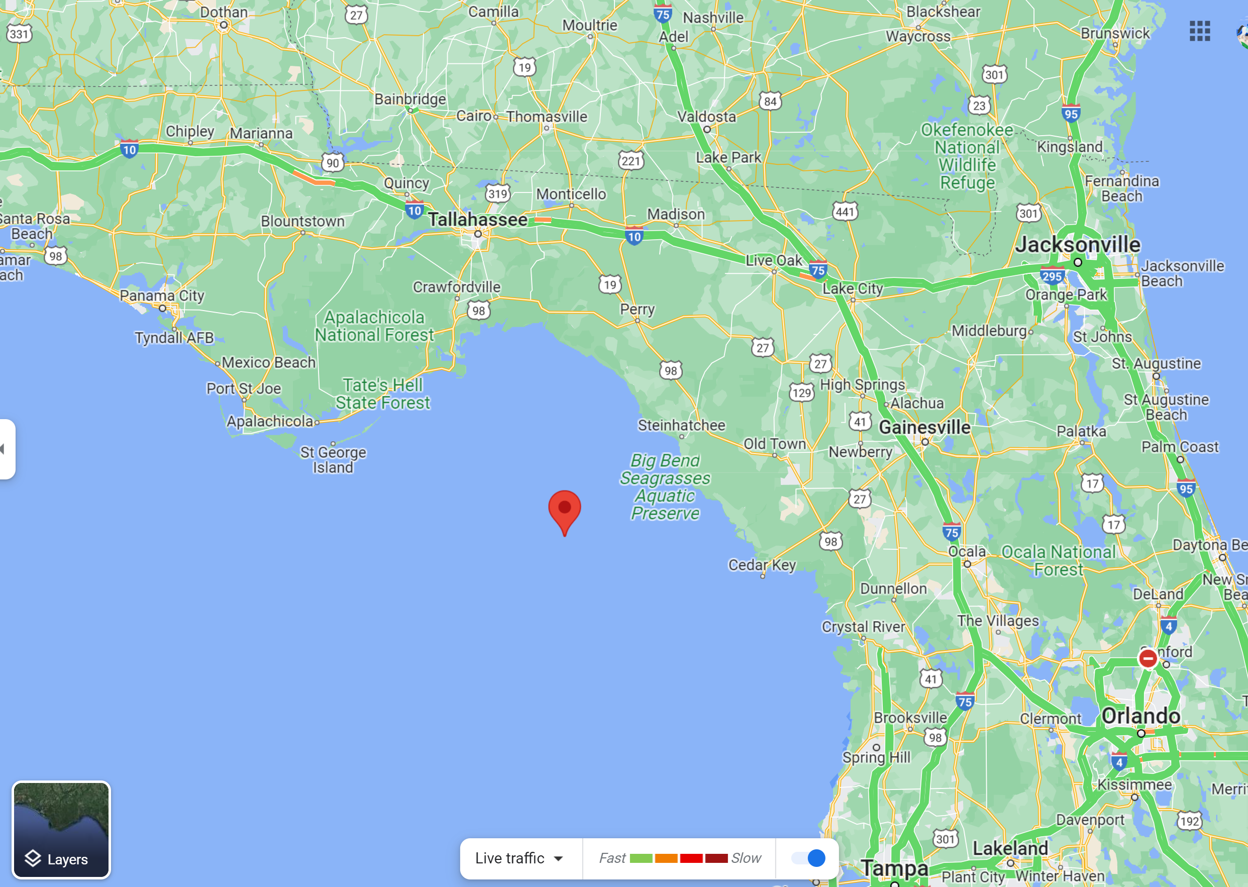
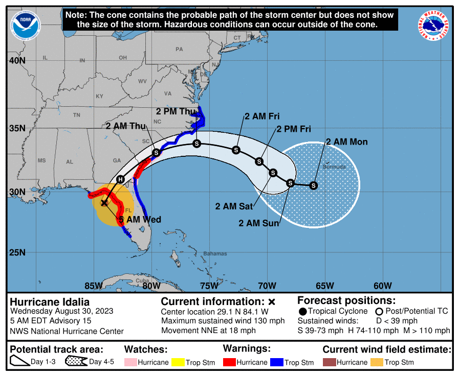
As feared and somewhat expected, the NHC is now forecasting that Idalia will be a 130 mph Cat 4 storm at landfall in the Big Bend area, about 20 miles ESE of St. Mark's and 35 miles NW of Steinhatchee (i.e., the middle of freakin' nowhere, with no towns within 10 miles of landfall including inland of there - which is not a bad thing) tomorrow morning around 8 am EDT. Other than the intensity, the only other change was a minor shift of the track about 10 miles further NW than earlier today at 5 pm. Good luck tomorrow to anyone in the path of this storm.

https://www.nhc.noaa.gov/text/refresh/MIATCDAT5+shtml/292056.shtml?

Based on the current strengthening trend and the favorable
thermodynamic and oceanic conditions, significant strengthening
seems likely up to landfall. The new official intensity forecast
calls for Idalia to reach category 4 strength at landfall. This is
fairly close to the HAFS And HWRF regional hurricane model
simulations. After the center moves back over the Atlantic,
significant restrengthening is not anticipated at this time due to
the expectation of strong vertical west-southwesterly vertical wind
shear.


FORECAST POSITIONS AND MAX WINDS

INIT 30/0300Z 27.7N 84.5W 95 KT 110 MPH
12H 30/1200Z 30.0N 83.9W 115 KT 130 MPH...ON COAST
24H 31/0000Z 32.3N 81.3W 70 KT 80 MPH...INLAND
36H 31/1200Z 33.5N 78.6W 50 KT 60 MPH...OVER WATER
48H 01/0000Z 33.8N 75.0W 50 KT 60 MPH
60H 01/1200Z 33.5N 72.5W 50 KT 60 MPH
72H 02/0000Z 32.9N 71.0W 45 KT 50 MPH
96H 03/0000Z 32.0N 69.4W 45 KT 50 MPH
120H 04/0000Z 31.0N 68.4W 45 KT 50 MPH
 
If I had to guess, I think Idalia will be best remembered for catastrophic storm surge in the Big Bend area, where a 12-16' surge could travel 5-10 miles inland, given how low/flat the elevation is in much of the area. Fortunately, there aren't too many towns/people to inundate there. And the 2nd thing I think the storm will be remembered for is the incredible wind/tree damage inland all the way to SE Georgia, since Idalia will be moving quickly (18 mph or so), so it will retain 90+ mph gusts 100-150 miles inland, which will likely do incredible damage to some heavily wooded areas and towns/cities.
 
We have a Cat 4 hurricane, now, with 130 mph winds, heading towards Perry, FL, with the coast about 45 miles to the NNE of Idalia, as per the map below, so the storm has almost 3 hours before landfall. The 12-16' storm surge in the Big Bend area will be absolutely catastrophic as will the winds within about 25-30 miles of the track as it comes ashore and even 20-30 miles inland of there.

The one change in the forecast is that Idalia is now expected to remain a hurricane into SE SC, with 100 mph winds as it passes just to the east of Valdosta GA around 2 pm and to be 75 mph as it reaches Hilton Head SC and to still be 70 mph as it reaches Charleston around 2 am Thursday, which is where the storm will reenter the Atlantic, although restrenthening is not expected after that as it moves east out to sea. So wind damage well into GA will be major to catastrophic with widespread downed trees and power lines and power outages, as well as flooding rains and tornadoes to the east of the track (there have been 11 so far).

Hurricane Idalia Tropical Cyclone Update
NWS National Hurricane Center Miami FL AL102023
600 AM EDT Wed Aug 30 2023

...CATASTROPHIC STORM SURGE AND DESTRUCTIVE WINDS EXPECTED IN THE
FLORIDA BIG BEND REGION THIS MORNING...
...6 AM POSITION UPDATE...

Data from an Air Force Reserve Hurricane Hunter aircraft indicate
that Idalia has maximum sustained winds of 130 mph (215 km/h) with
higher gusts.

The estimated minimum pressure indicated by Air Force Reserve
Hurricane Hunter aircraft data is 942 mb (27.82 inches).

SUMMARY OF 600 AM EDT...1000 UTC...INFORMATION
----------------------------------------------
LOCATION...29.3N 83.9W
ABOUT 55 MI...90 KM WNW OF CEDAR KEY FLORIDA
ABOUT 95 MI...150 KM SSE OF TALLAHASSEE FLORIDA
MAXIMUM SUSTAINED WINDS...130 MPH...215 KM/H
PRESENT MOVEMENT...NNE OR 15 DEGREES AT 17 MPH...27 KM/H
MINIMUM CENTRAL PRESSURE...942 MB...27.82 INCHES

FORECAST POSITIONS AND MAX WINDS

INIT 30/0900Z 29.1N 84.1W 115 KT 130 MPH
12H 30/1800Z 31.0N 82.7W 85 KT 100 MPH...INLAND
24H 31/0600Z 33.1N 79.6W 60 KT 70 MPH...INLAND
36H 31/1800Z 33.8N 76.1W 50 KT 60 MPH...OVER WATER
48H 01/0600Z 33.3N 72.7W 50 KT 60 MPH
60H 01/1800Z 32.4N 70.7W 45 KT 50 MPH
72H 02/0600Z 31.5N 69.5W 45 KT 50 MPH
96H 03/0600Z 30.7N 68.0W 45 KT 50 MPH
120H 04/0600Z 30.5N 66.0W 45 KT 50 MPH


SypcwBL.png


vcBvksp.png


4LD6MOE.png


AVQTIcV.png
 
Last edited:
For the 7 am update, the NHC dropped the winds to 125 mph, as the storm is undergoing an eyewall replacement cycle, so it has weakened a touch, meaning it has almost no time left to restrengthen before landfall in an hour or two, which is a good thing.

Hurricane Idalia Tropical Cyclone Update
NWS National Hurricane Center Miami FL AL102023
700 AM EDT Wed Aug 30 2023

...CATASTROPHIC STORM SURGE AND DESTRUCTIVE WINDS OCCURRING IN THE
FLORIDA BIG BEND REGION...
...7 AM POSITION UPDATE...

Radar and Air Force Reserve Hurricane Hunter aircraft data
indicate that an eyewall replacement cycle has begun. Idalia's
maximum sustained winds are now estimated near 125 mph (205 km/h)
with higher gusts. This change in wind speed does not diminish the
threat of catastrophic storm surge and damaging winds.

The estimated minimum pressure indicated by Air Force Reserve
Hurricane Hunter aircraft data is 947 mb (27.96 inches).
 
We have a 7:45 am landfall. Storm surge in the Clearwater/Tampa area has been measured at 6' (4-7' predicted) and the water is still rising. Surge will be much greater along the Big Bend area, as will the winds, of course.

Hurricane Idalia Tropical Cyclone Update
NWS National Hurricane Center Miami FL AL102023
745 AM EDT Wed Aug 30 2023

...EXTREMELY DANGEROUS CATEGORY 3 HURRICANE IDALIA MAKES LANDFALL
IN THE FLORIDA BIG BEND...
...745 AM POSITION UPDATE...

NOAA Doppler radar imagery indicate that the eye of Idalia made
landfall along the coast of the Florida Big Bend near Keaton Beach
around 745 AM EDT (1145 UTC). Data from an Air Force Reserve
Hurricane Hunter aircraft indicate that Idalia's maximum sustained
winds were near 125 mph (205 km/h). The latest minimum pressure
central pressure estimated from reconnaissance data is 949 mb (28.02
inches).

SUMMARY OF 745 AM EDT...1145 UTC...INFORMATION
----------------------------------------------
LOCATION...29.8N 83.6W
ABOUT 20 MI...30 KM S OF PERRY FLORIDA
ABOUT 55 MI...90 KM NW OF CEDAR KEY FLORIDA
MAXIMUM SUSTAINED WINDS...125 MPH...205 KM/H
PRESENT MOVEMENT...NNE OR 20 DEGREES AT 18 MPH...30 KM/H
MINIMUM CENTRAL PRESSURE...949 MB...28.02 INCHES
 
Thought this before/after from Horseshoe Beach, about 30 miles SE of landfall (in Keaton Beach, just NW of Fish Creek) really showed the surge well. Record storm surges being reported in Cedar Key and much of the Big Bend area; even got 6' in Clearwater.


Winds are down to 105 mph (at the surface, winds like this will generally only be seen in gusts, due to the frictional effects of land) as the storm is now nearing the GA border near Madison FL and will head just SE of Valdosta (it's 25 miles south of Valdosta now, heading NNE), which will likely get raked by the eyewall.
Got 6' surge in the Alafia river(Riverview) as well. Will probably go a little higher. King tide is like 2pm.
Flooding is really the only negative impact to the area. St. Pete Beach and pretty much the whole barrier Island has a bunch of standing water too.
 
Got 6' surge in the Alafia river(Riverview) as well. Will probably go a little higher. King tide is like 2pm.
Flooding is really the only negative impact to the area. St. Pete Beach and pretty much the whole barrier Island has a bunch of standing water too.
Yep, once the track moved further offshore from the Tampa area, surge became the biggest and really only significant risk, other than the risk of a rogue tornado. There have been at least a dozen reported, but not sure if any in that area.

https://twitter.com/search?q=florida tornado&src=typed_query
 
As mentioned earlier, it's looking like the surge was likely record levels from Tampa northward up through the Big Bend area.

 
My folks made it to key west, although their flight outta Miami was delayed cause the crew never showed up. Lol.
 
  • Like
Reactions: RU848789
Yep, once the track moved further offshore from the Tampa area, surge became the biggest and really only significant risk, other than the risk of a rogue tornado. There have been at least a dozen reported, but not sure if any in that area.

https://twitter.com/search?q=florida tornado&src=typed_query
The only real impact in the Tampa area was the surge and standing water from the downpours. My folks in Riverview are sitting at their Tiki bar as I type😂

People up by Big Bend got beat up pretty good and we hope the best for them. I don't have any folks up that way but was watching ABC Tampa for updates.
 
There are now 8 hurricanes that have hit US shores Category 3 or higher since 2017.

Between 2005 and 2017 there were 0.
 
We have a Cat 4 hurricane, now, with 130 mph winds, heading towards Perry, FL, with the coast about 45 miles to the NNE of Idalia, as per the map below, so the storm has almost 3 hours before landfall. The 12-16' storm surge in the Big Bend area will be absolutely catastrophic as will the winds within about 25-30 miles of the track as it comes ashore and even 20-30 miles inland of there.

The one change in the forecast is that Idalia is now expected to remain a hurricane into SE SC, with 100 mph winds as it passes just to the east of Valdosta GA around 2 pm and to be 75 mph as it reaches Hilton Head SC and to still be 70 mph as it reaches Charleston around 2 am Thursday, which is where the storm will reenter the Atlantic, although restrenthening is not expected after that as it moves east out to sea. So wind damage well into GA will be major to catastrophic with widespread downed trees and power lines and power outages, as well as flooding rains and tornadoes to the east of the track (there have been 11 so far).

Hurricane Idalia Tropical Cyclone Update
NWS National Hurricane Center Miami FL AL102023
600 AM EDT Wed Aug 30 2023

...CATASTROPHIC STORM SURGE AND DESTRUCTIVE WINDS EXPECTED IN THE
FLORIDA BIG BEND REGION THIS MORNING...
...6 AM POSITION UPDATE...

Data from an Air Force Reserve Hurricane Hunter aircraft indicate
that Idalia has maximum sustained winds of 130 mph (215 km/h) with
higher gusts.

The estimated minimum pressure indicated by Air Force Reserve
Hurricane Hunter aircraft data is 942 mb (27.82 inches).

SUMMARY OF 600 AM EDT...1000 UTC...INFORMATION
----------------------------------------------
LOCATION...29.3N 83.9W
ABOUT 55 MI...90 KM WNW OF CEDAR KEY FLORIDA
ABOUT 95 MI...150 KM SSE OF TALLAHASSEE FLORIDA
MAXIMUM SUSTAINED WINDS...130 MPH...215 KM/H
PRESENT MOVEMENT...NNE OR 15 DEGREES AT 17 MPH...27 KM/H
MINIMUM CENTRAL PRESSURE...942 MB...27.82 INCHES

FORECAST POSITIONS AND MAX WINDS

INIT 30/0900Z 29.1N 84.1W 115 KT 130 MPH
12H 30/1800Z 31.0N 82.7W 85 KT 100 MPH...INLAND
24H 31/0600Z 33.1N 79.6W 60 KT 70 MPH...INLAND
36H 31/1800Z 33.8N 76.1W 50 KT 60 MPH...OVER WATER
48H 01/0600Z 33.3N 72.7W 50 KT 60 MPH
60H 01/1800Z 32.4N 70.7W 45 KT 50 MPH
72H 02/0600Z 31.5N 69.5W 45 KT 50 MPH
96H 03/0600Z 30.7N 68.0W 45 KT 50 MPH
120H 04/0600Z 30.5N 66.0W 45 KT 50 MPH


SypcwBL.png


vcBvksp.png


4LD6MOE.png


AVQTIcV.png


They were way off on the Hilton Head projection. Winds were well below 75…. Sustained winds (not the occasional gust) maxed out around 30 mph or so, with most of the day in the 20’s). If it was 75, I would have had major damage to my 50 trees; most of which are 60 to 100 feet tall. Just leaves and a few small branches came down.
 
Last edited:
There are now 8 hurricanes that have hit US shores Category 3 or higher since 2017.

Between 2005 and 2017 there were 0.
and what is your point

Officially, the decade with the most Category 5 hurricanes is 2000–2009, with eight Category 5 hurricanes having occurred: Isabel (2003), Ivan (2004), Emily (2005), Katrina (2005), Rita (2005), Wilma (2005), Dean (2007), and Felix (2007).

Although Category 5 storms are by definition the strongest, hurricanes such as Katrina, which made landfall near New Orleans as a Category 3 in 2005, and Maria, which made landfall in Puerto Rico as a Category 4 in 2017, have often been more devastating in loss of life and financial impact.

Here, we look back at four storms that hit the U.S. as a Category 5.

1935 Labor Day Hurricane​


Fallen trees lie scattered in Long Key, Fla., after the 1935 Labor Day Hurricane — the strongest hurricane on record to make U.S. landfall.

/ AP
/
AP
Fallen trees lie scattered in Long Key, Fla., after the 1935 Labor Day Hurricane — the strongest hurricane on record to make U.S. landfall.
The 1935 Labor Day Hurricane is considered the strongest storm ever recorded to make landfall in the U.S., smashing into the Florida Keys on Sept. 2, 1935, with winds of 185 mph. It killed an estimated 409 people. Although it made its way up the U.S. East Coast, "practically all losses from the hurricane were suffered in Florida, with most occurring in the Florida Keys. A swath of destruction 40 [miles] wide occurred across the Keys, from just south of Key Largo to just north of Marathon. Most manmade structures were destroyed by the hurricane's Category 5 winds, which gusted at times to over 200 mph, and the complete inundation of the islands by a 15-20 ft storm surge," according to Hurricanes: Science and Society, a website run by the University of Rhode Island's Graduate School of Oceanography.

Hurricane Camille (1969)​


A fishing vessel driven ashore by Hurricane Camille in Biloxi, Miss., in 1969.

/ HUM Images/Universal Images Group/Getty Images
/
HUM Images/Universal Images Group/Getty Images
A fishing vessel driven ashore by Hurricane Camille in Biloxi, Miss., in 1969.
Hurricane Camille, the second-strongest storm on record to come ashore in the continental U.S., had sustained winds of more than 170 mph when it hit Mississippi in the late evening of Aug. 17, 1969. More than 250 people were killed, many in Virginia due to massive flooding the storm brought to that state. Camille tracked north-northwest across the Gulf of Mexico, becoming a Category 5 the day before making landfall.

The National Oceanic and Atmospheric Administration (NOAA) says: "The impacts of Hurricane Camille were felt across much of the southeast U.S., especially southeast Mississippi and southwest Alabama. Most of the inland damage was a result of fallen trees and power lines, while damage on the immediate coast was caused by both wind and storm surge. Communities saw homes and buildings damaged or destroyed, fallen trees, and flooded roads. Additionally, crops in Mississippi and Alabama took an enormous hit — peach and pecan orchards were completely destroyed, and more than 20,000 acres of corn were flattened. The majority of the crop damage — about 90% — was due to the high winds while just 10% is attributed to the intense rainfall."

Hurricane Andrew (1992)​


On Aug. 24, 1992, Andrew made landfall in South Miami-Dade County with maximum sustained winds of 165 mph. Although 23 deaths were directly attributed to the storm, "Hurricane Andrew destroyed more than 50,000 homes and caused an estimated $26 billion in damage, making it at the time the most expensive natural disaster in United States history, not to be surpassed until Hurricane Katrina 13 years later," NOAA says.

Hurricane Michael (2018)​


The Cooter Stew Cafe taking on water as Hurricane Michael pushes a storm surge up the Wakulla and Saint Marks rivers, which come together here in Saint Marks, Fla., on Oct. 10, 2018.

/ Mark Wallheiser/Getty Images
/
Mark Wallheiser/Getty Images
The Cooter Stew Cafe taking on water as Hurricane Michael pushes a storm surge up the Wakulla and Saint Marks rivers, which come together here in Saint Marks, Fla., on Oct. 10, 2018.
Hurricane Michael made landfall in the Florida Panhandle on Oct. 10, 2018, as a Category 5 storm, with maximum sustained winds of 161 mph. The National Weather Service says, "Wind and storm surge caused catastrophic damage, particularly in the Panama City Beach and Mexico Beach areas. Eight direct fatalities were reported: seven in Florida and one in Georgia. In addition, 43 indirect deaths were attributed to the storm."
 
They were way off on the Hilton Head projection. Winds were well below 75…. Sustained winds (not the occasional gust) maxed out around 30 mph or so, with most of the day in the 20’s). If it was 75, I would have had major damage to my 50 trees; most of which are 60 to 100 feet tall. Just leaves and a few small branches came down.

@RU848789 will probably yell at me for saying this, but the wind velocities that are reported almost never verify on landfall.
 
@RU848789 will probably yell at me for saying this, but the wind velocities that are reported almost never verify on landfall.
Nope, talked about this yesterday and many times in the past. There are many reasons for this and unfortunately, the NHC and meteorologists don't necessarily do a good job of explaining this. The two biggest reasons are that i) the winds will almost always be greater over water, which has much less friction than land, so hurricane winds drop at ground level as soon as the storm is over land and ii) the maximum measured winds for a storm are winds at 10 meters (33'), but winds drop significantly between 33' and the ground, due to frictional effects.

As per the attached article on this, a good rule of thumb is usually that the maximum sustained storm winds at 33' are quite often the maximum reported wind gusts at the ground. In addition, the measured maximum storm winds are only measured in a small portion of the storm and are not the same windspeeds throughout the storm, plus, the network of accurate wind measuring devices is very sparse, so often the highest winds simply aren't recorded. Often, the best indication of max ground level winds is the damage observed, which is how tornado wind speeds (they have much greater wind speeds than hurricanes, usually) are measured. That's how it was well known that Sandy, for example, clearly had at least 80-90 mph wind gusts inland of the NJ coast, given the huge number of downed trees, whereas those inland areas generally only measured 70-75 mph wind gusts.

https://www.washingtonpost.com/weather/2020/09/05/maximum-sustained-winds/
 
They were way off on the Hilton Head projection. Winds were well below 75…. Sustained winds (not the occasional gust) maxed out around 30 mph or so, with most of the day in the 20’s). If it was 75, I would have had major damage to my 50 trees; most of which are 60 to 100 feet tall. Just leaves and a few small branches came down.
Disagree for the most part. About 30 trees reported down on Hilton Head. That doesn't happen without at least 65-75 mph winds. Doesn't mean you had gusts that high, as winds are not anywhere near uniform even over short distances, but those kinds of winds were clearly in the area.

https://www.wtoc.com/2023/08/31/not...island-residents-grateful-low-impacts-idalia/

https://www.weather.gov/media/pqr/wind/wind.pdf

65-75? Not even close. 30 trees is nothing. Do you know how many trees there are in HHI? It was estimated that HHI LOST 120,000 trees during Hurricane Matthew(look it up). Weather sites had the wind in the teens early, upper 20’s in early afternoon and peaked in the low 30’s . With winds that high (in the 70 range) I would have had a ton of debris on my property. And the chart you posted isn’t as relevant in HHI. It doesn’t take much to bring down a tree with saturated ground and sandy soil. I had a 90 foot pine come down on my HHI property a couple of years ago and it wasn’t even a tropical storm.
 
Last edited:
65-75? Not even close. 30 trees is nothing. Do you know how many trees there are in HHI? It was estimated that HHI LOST 120,000 trees during Hurricane Matthew(look it up). Weather sites had the wind in the teens early, upper 20’s in early afternoon and peaked in the low 30’s . With winds that high (in the 70 range) I would have had a ton of debris on my property
Matthew was a very strong Cat 2 with 105 mph winds at landfall near Hilton Head - huge difference from 65-75 mph winds with Idalia, which is why so many more trees came down. 30 trees is way, way less but not nothing and 30 trees don't come down without gusts over 65 mph in some locations. Period.
 
Matthew was a very strong Cat 2 with 105 mph winds at landfall near Hilton Head - huge difference from 65-75 mph winds with Idalia, which is why so many more trees came down. 30 trees is way, way less but not nothing and 30 trees don't come down without gusts over 65 mph in some locations. Period.

i looked at every weather service throughout the day as I had a lot at risk. Winds were not close to what was expected earlier in the day. I added to my post about why it’s easy for a tree to come down in HHI. Also, many trees in HHI are diseased and are structurally weak. I have had to take down 3 large water oaks for that reason.
 
Last edited:
As expected, this system has become more organized and was deemed a tropical depression this afternoon and is expected to become tropical storm Idalia sometime Sunday. More worrisome is that it's looking like the more bullish models are looking like they were probably correct, as the NHC forecast is now calling for Idalia to become a Cat 1 hurricane before landfall on the Florida Gulf Coast, somewhere between about Panama City and Tampa early Wednesday. And even more worrisome is the very warm waters the storm will traverse on its path towards Florida, as well as the forecast relaxing wind shear, both of which are potential ingredients for strengthening beyond Cat 1, as a few models have shown.

Also, keep in mind that if the storm track is somewhat closer to the FL coast than shown below, large areas of the coast, including Tampa/St. Pete, could be in for significant storm surge, even if the storm misses them by 20-50 miles to the west (kind of like how Naples/Marco Island were hammered by storm surge, even though the storm came ashore near Ft. Myers, well to the north). Having said all that, the uncertainty on track and intensity are very high, but hopefully, we'll get much better storm structure data tomorrow, when recon flights are sent into the storm and the data then ingested into the models, producing more accurate projections. One thing that's fairly high confidence is that this storm will be shunted to the east by a major approaching trough once the storm reaches the Carolinas and should not pose much of a threat to our area at all late next week.


Y5aTrga.png


FORECAST POSITIONS AND MAX WINDS

INIT 27/0300Z 21.1N 86.4W 30 KT 35 MPH
12H 27/1200Z 20.9N 86.4W 35 KT 40 MPH
24H 28/0000Z 20.9N 86.2W 40 KT 45 MPH
36H 28/1200Z 21.6N 85.9W 45 KT 50 MPH
48H 29/0000Z 23.1N 85.7W 55 KT 65 MPH
60H 29/1200Z 25.0N 85.5W 65 KT 75 MPH
72H 30/0000Z 27.5N 84.8W 70 KT 80 MPH
96H 31/0000Z 32.7N 81.5W 45 KT 50 MPH...INLAND
120H 01/0000Z 35.2N 76.7W 35 KT 40 MPH...INLAND
Kudos to the NHC and the improved models on Idalia's forecast, especially with regard to track. This first track forecast ended up being within 10 miles of the eventual landfall on Keaton Beach and the NHC track stayed within 55 miles over the duration of forecasts. Amazing actually. And even though the intensity forecast early on ended up being low, the NHC kept commenting about how conditions were favorable for much more strengthening, beyond their forecast and 60 hours before landfall they already were forecasting a storm with over 100 mph winds at landfall, so people were pretty well warned.
 
ADVERTISEMENT
ADVERTISEMENT