
Can't make this up. You're taking the high road and in the same post call me a derogatory name you guys use on the CE board? Priceless.Well im taking the high road..nimbers is on an island now
Colleges
- American Athletic
- Atlantic Coast
- Big 12
- Big East
- Big Ten
- Colonial
- Conference USA
- Independents (FBS)
- Junior College
- Mountain West
- Northeast
- Pac-12
- Patriot League
- Pioneer League
- Southeastern
- Sun Belt
- Army
- Charlotte
- East Carolina
- Florida Atlantic
- Memphis
- Navy
- North Texas
- Rice
- South Florida
- Temple
- Tulane
- Tulsa
- UAB
- UTSA
- Boston College
- California
- Clemson
- Duke
- Florida State
- Georgia Tech
- Louisville
- Miami (FL)
- North Carolina
- North Carolina State
- Pittsburgh
- Southern Methodist
- Stanford
- Syracuse
- Virginia
- Virginia Tech
- Wake Forest
- Arizona
- Arizona State
- Baylor
- Brigham Young
- Cincinnati
- Colorado
- Houston
- Iowa State
- Kansas
- Kansas State
- Oklahoma State
- TCU
- Texas Tech
- UCF
- Utah
- West Virginia
- Illinois
- Indiana
- Iowa
- Maryland
- Michigan
- Michigan State
- Minnesota
- Nebraska
- Northwestern
- Ohio State
- Oregon
- Penn State
- Purdue
- Rutgers
- UCLA
- USC
- Washington
- Wisconsin
High Schools
- Illinois HS Sports
- Indiana HS Sports
- Iowa HS Sports
- Kansas HS Sports
- Michigan HS Sports
- Minnesota HS Sports
- Missouri HS Sports
- Nebraska HS Sports
- Oklahoma HS Sports
- Texas HS Hoops
- Texas HS Sports
- Wisconsin HS Sports
- Cincinnati HS Sports
- Delaware
- Maryland HS Sports
- New Jersey HS Hoops
- New Jersey HS Sports
- NYC HS Hoops
- Ohio HS Sports
- Pennsylvania HS Sports
- Virginia HS Sports
- West Virginia HS Sports
ADVERTISEMENT
You are using an out of date browser. It may not display this or other websites correctly.
You should upgrade or use an alternative browser.
You should upgrade or use an alternative browser.
OT: Now-Hurricane Idalia to Hit Florida Big Bend as a Major Hurricane Weds am
- Thread starter RU848789
- Start date

I know I've been posting about Franklin in the general tropical thread, but that gets little action vs. this thread and it's worth noting that Franklin has winds of 150 mph now (strong Cat 4) and might even make it to Cat 5 overnight, before starting to weaken a bit. It's a beast of a storm right now, which fortunately will miss Bermuda by over 100 miles and also won't get as far north as the Canadian Maritimes. Would hate to be on a boat near there, though. Impressive...
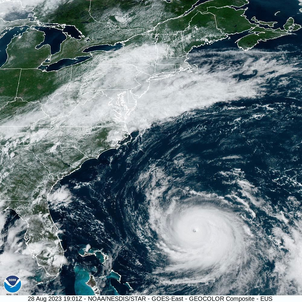
Idalia really looking healthier - much more concentric convection around the center - think it's going to be a cane shortly...
Edit - not so fast, still a TS, but the discussion just said it's almost a hurricane and many of the pros on the message boards think it's already a hurricane, but 5 mph really doesn't matter much. Almost zero change in the track and intensity forecasts with landfall likely in the Big Bend area as a 120 mph Cat 3 storm.
Tropical Storm Idalia Discussion Number 10
NWS National Hurricane Center Miami FL AL102023
1000 PM CDT Mon Aug 28 2023
Idalia is producing intense bursts of convection near the center,
with an overall comma-shaped cloud pattern along with a dry slot
over the western part of the circulation. Upper-level outflow is
restricted over the northwestern quadrant. Radar images from
the Meteorological Service of Cuba show a partial eyewall forming.
Flight-level and dropwindsonde data from NOAA and Air Force aircraft
indicate that Idalia is very near hurricane strength. The maximum
winds are set again to 60 kt for this advisory.
The system has moved a bit slower than earlier today with an
initial motion estimate of just slightly east of due north at
around 7 kt. Idalia should be steered northward along the western
side of a mid-level ridge and then turn north-northeastward due to
a trough to its northwest. This track will take the center across
the northeastern Gulf coast on Wednesday morning, and over
northern Florida and southeastern Georgia thereafter. In 2 to 3
days, a mid-tropospheric trough moving off the eastern U.S. coast
will likely cause the tropical cyclone to turn northeastward to
eastward off the coast of the Carolinas. The official track
forecast for this advisory is essentially the same as the previous
one. This is near the middle of the track guidance, which are
fairly tightly clustered, with the GFS on the left side and the
ECMWF on the right side.
Although Idalia is currently experiencing some moderate
northwesterly vertical wind shear, the dynamical guidance indicates
that the shear will lessen while the system is over the eastern
Gulf of Mexico. This, along with a conducive thermodynamic
atmospheric environment and high oceanic heat content, should cause
Idalia to strengthen rapidly in the 12- to 36-hour time frame. The
official intensity forecast, like the previous one, shows the system
becoming a major hurricane before landfall along the Florida Gulf
coast. This is in general agreement with the regional hurricane
hurricane models, HAFS and HWRF, but above much of the other
intensity guidance.
Idalia is forecast to move into an area that is highly susceptible
to storm surge, and regardless of the cyclone's specific landfall
intensity, there is increasing confidence that a significant storm
surge event will occur.
KEY MESSAGES:
1. There is a danger of life-threatening storm surge inundation
along portions of the Florida Gulf Coast where a Storm Surge Warning
is in effect, including Tampa Bay and the Big Bend region of
Florida. Inundation of 8 to 12 feet above ground level is expected
somewhere between Chassahowitzka and Aucilla River. Residents in
these areas should follow any advice given by local officials.
2. Hurricane conditions are expected within portions of the
Hurricane Warning area along the Florida Gulf Coast, with the
potential for destructive winds where the core of Idalia moves
onshore. Strong winds will also spread inland across portions of
northern Florida near the track of the center of Idalia.
3. Heavy rainfall from Tropical Storm Idalia is expected across
portions of western Cuba and may produce areas of flash and urban
flooding as well as landslides. Areas of flash and urban flooding,
some of which may be locally significant, are expected across
portions of the west coast of Florida, the Florida Panhandle, and
southern Georgia Tuesday into Wednesday, spreading into portions of
the eastern Carolinas Wednesday into Thursday.
FORECAST POSITIONS AND MAX WINDS
INIT 29/0300Z 22.0N 85.0W 60 KT 70 MPH
12H 29/1200Z 23.7N 85.0W 75 KT 85 MPH
24H 30/0000Z 26.2N 84.6W 90 KT 105 MPH
36H 30/1200Z 29.0N 83.7W 105 KT 120 MPH
48H 31/0000Z 31.5N 81.6W 50 KT 60 MPH...INLAND
60H 31/1200Z 33.2N 78.8W 50 KT 60 MPH...OVER WATER
72H 01/0000Z 34.0N 76.0W 50 KT 60 MPH
96H 02/0000Z 33.5N 72.0W 45 KT 50 MPH
120H 03/0000Z 33.0N 70.0W 45 KT 50 MPH
Last edited:
Idalia really looking healthier - much more concentric convection around the center - think it's going to be a cane shortly...
Edit - not so fast, still a TS, but the discussion just said it's almost a hurricane and many of the pros on the message boards think it's already a hurricane, but 5 mph really doesn't matter much. Almost zero change in the track and intensity forecasts with landfall likely in the Big Bend area as a 120 mph Cat 3 storm.
Tropical Storm Idalia Discussion Number 10
NWS National Hurricane Center Miami FL AL102023
1000 PM CDT Mon Aug 28 2023
Idalia is producing intense bursts of convection near the center,
with an overall comma-shaped cloud pattern along with a dry slot
over the western part of the circulation. Upper-level outflow is
restricted over the northwestern quadrant. Radar images from
the Meteorological Service of Cuba show a partial eyewall forming.
Flight-level and dropwindsonde data from NOAA and Air Force aircraft
indicate that Idalia is very near hurricane strength. The maximum
winds are set again to 60 kt for this advisory.
The system has moved a bit slower than earlier today with an
initial motion estimate of just slightly east of due north at
around 7 kt. Idalia should be steered northward along the western
side of a mid-level ridge and then turn north-northeastward due to
a trough to its northwest. This track will take the center across
the northeastern Gulf coast on Wednesday morning, and over
northern Florida and southeastern Georgia thereafter. In 2 to 3
days, a mid-tropospheric trough moving off the eastern U.S. coast
will likely cause the tropical cyclone to turn northeastward to
eastward off the coast of the Carolinas. The official track
forecast for this advisory is essentially the same as the previous
one. This is near the middle of the track guidance, which are
fairly tightly clustered, with the GFS on the left side and the
ECMWF on the right side.
Although Idalia is currently experiencing some moderate
northwesterly vertical wind shear, the dynamical guidance indicates
that the shear will lessen while the system is over the eastern
Gulf of Mexico. This, along with a conducive thermodynamic
atmospheric environment and high oceanic heat content, should cause
Idalia to strengthen rapidly in the 12- to 36-hour time frame. The
official intensity forecast, like the previous one, shows the system
becoming a major hurricane before landfall along the Florida Gulf
coast. This is in general agreement with the regional hurricane
hurricane models, HAFS and HWRF, but above much of the other
intensity guidance.
Idalia is forecast to move into an area that is highly susceptible
to storm surge, and regardless of the cyclone's specific landfall
intensity, there is increasing confidence that a significant storm
surge event will occur.
KEY MESSAGES:
1. There is a danger of life-threatening storm surge inundation
along portions of the Florida Gulf Coast where a Storm Surge Warning
is in effect, including Tampa Bay and the Big Bend region of
Florida. Inundation of 8 to 12 feet above ground level is expected
somewhere between Chassahowitzka and Aucilla River. Residents in
these areas should follow any advice given by local officials.
2. Hurricane conditions are expected within portions of the
Hurricane Warning area along the Florida Gulf Coast, with the
potential for destructive winds where the core of Idalia moves
onshore. Strong winds will also spread inland across portions of
northern Florida near the track of the center of Idalia.
3. Heavy rainfall from Tropical Storm Idalia is expected across
portions of western Cuba and may produce areas of flash and urban
flooding as well as landslides. Areas of flash and urban flooding,
some of which may be locally significant, are expected across
portions of the west coast of Florida, the Florida Panhandle, and
southern Georgia Tuesday into Wednesday, spreading into portions of
the eastern Carolinas Wednesday into Thursday.
FORECAST POSITIONS AND MAX WINDS
INIT 29/0300Z 22.0N 85.0W 60 KT 70 MPH
12H 29/1200Z 23.7N 85.0W 75 KT 85 MPH
24H 30/0000Z 26.2N 84.6W 90 KT 105 MPH
36H 30/1200Z 29.0N 83.7W 105 KT 120 MPH
48H 31/0000Z 31.5N 81.6W 50 KT 60 MPH...INLAND
60H 31/1200Z 33.2N 78.8W 50 KT 60 MPH...OVER WATER
72H 01/0000Z 34.0N 76.0W 50 KT 60 MPH
96H 02/0000Z 33.5N 72.0W 45 KT 50 MPH
120H 03/0000Z 33.0N 70.0W 45 KT 50 MPH
Any chance of reorganization over the Atlantic?
Unlikely, as the storm will be feeling a lot more shear from the big trough coming through the eastern US by Wednesday, which is shunting the storm east from SC/NC, rather than allowing it to head NE, like most Atlantic systems, but then again, beyond 5-6 days is difficult to predict.Any chance of reorganization over the Atlantic?
Unlikely, as the storm will be feeling a lot more shear from the big trough coming through the eastern US by Wednesday, which is shunting the storm east from SC/NC, rather than allowing it to head NE, like most Atlantic systems, but then again, beyond 5-6 days is difficult to predict.
Thanks!
No impact, especially that far west.How we looking at perdido key? Have a flight out wed.
Similarly to Tampa, except a bit worse, as it's ~20 miles north of Clearwater/Tampa, so the peak storm surge forecast there is 6-9' vs. 4-7' in Clearwater and they're more likely to get sustained hurricane force winds at the coast (70-75 mph range vs. maybe 60-65 mph in Clearwater). That's assuming the track goes towards Steinhatchee to Cedar Key, which is not a given. Recall that Ian shifted its track from about Tampa to just north of Fort Myers (~90 miles) in the last 2 days before landfall, so it's still possible that Port Richey will be impacted more seriously if the track shifts SE.How will Port Richey be impacted?
TWC this morning talking about the GFS showing potential for Idalia to reorg off the coast of FL and loop back, clockwise, toward the SE U.S. One model and too early to give it too much credence, but worth watching.
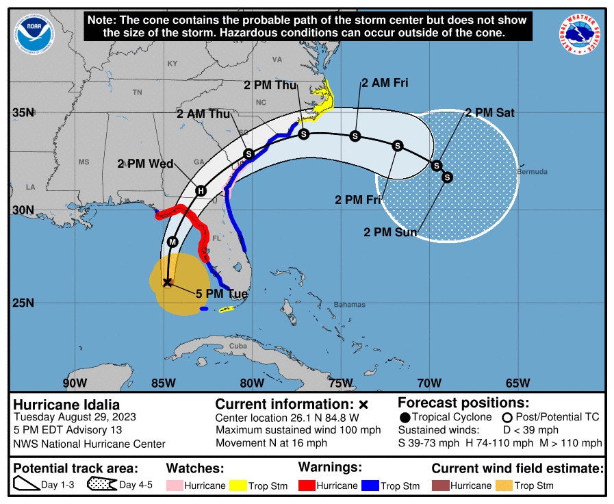
As of 5 am, Hurricane Idalia was born with 75 mph winds and as of 8 am those winds are up to 80 mph and the storm is clearly getting its act together, with an eye now visible and much more symmetry of convection around the low pressure center. The storm has also taken off in terms of movement - it was meandering for the past few days, but is now moving north at 14 mph and the projected landfall is still in the Big Bend area (it's been remarkably consistent since the storm formed), centered on Steinhatchee, with the envelope for landfall having now narrowed to between about just east of Apalachicola to about Crystal River (just south of Ceder Key).
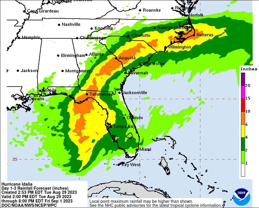
The intensity forecast hasn't changed with the storm expected to intensify rapidly from now through landfall Wednesday around sunrise reaching Cat 3 status with 120 mph winds (and a Cat 4 is still not out of the question, i.e., up to 130 mph winds, as intensity forecasts are still much less accurate than track forecasts). As per the NHC and previous posts, the storm surge risk is major to catastrophic along and to the SE of the track, winds will obviously be catastrophic within 30 miles of landfall and damage will likely be major even inland towards SE GA, rainfall will be torrential with flooding inland (4-8" common within 50-100 miles of the track through the Carolinas), tornadoes are likely along and SE of the track.
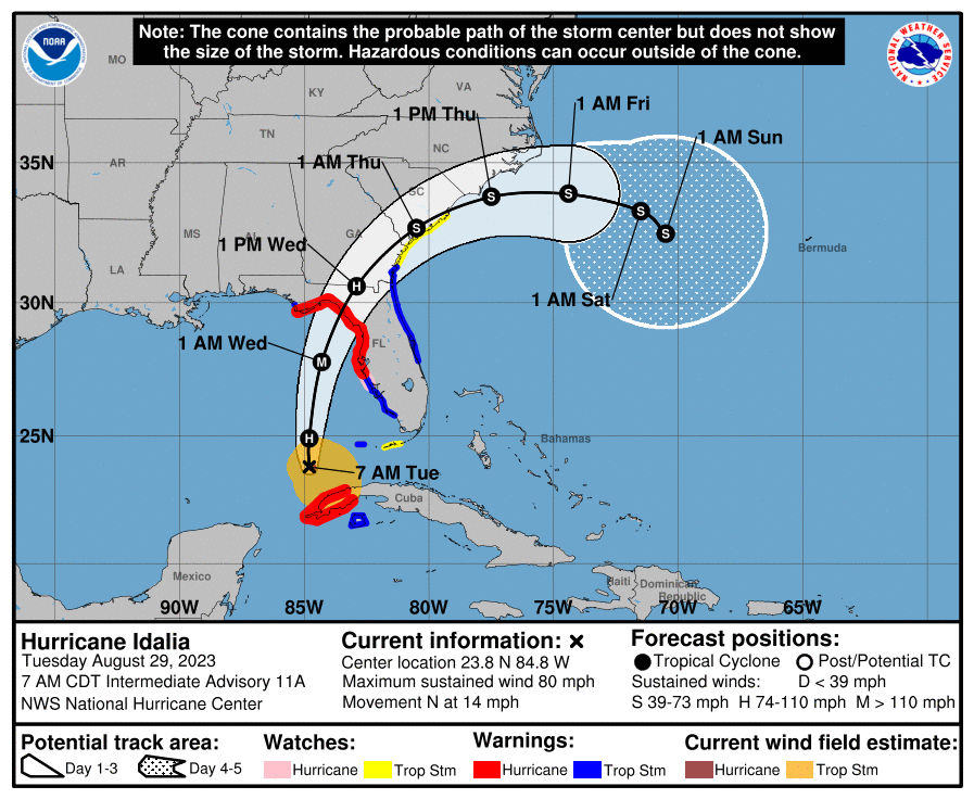
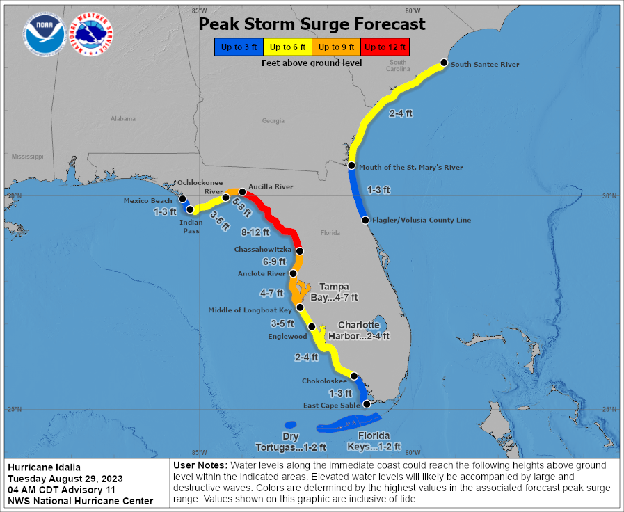
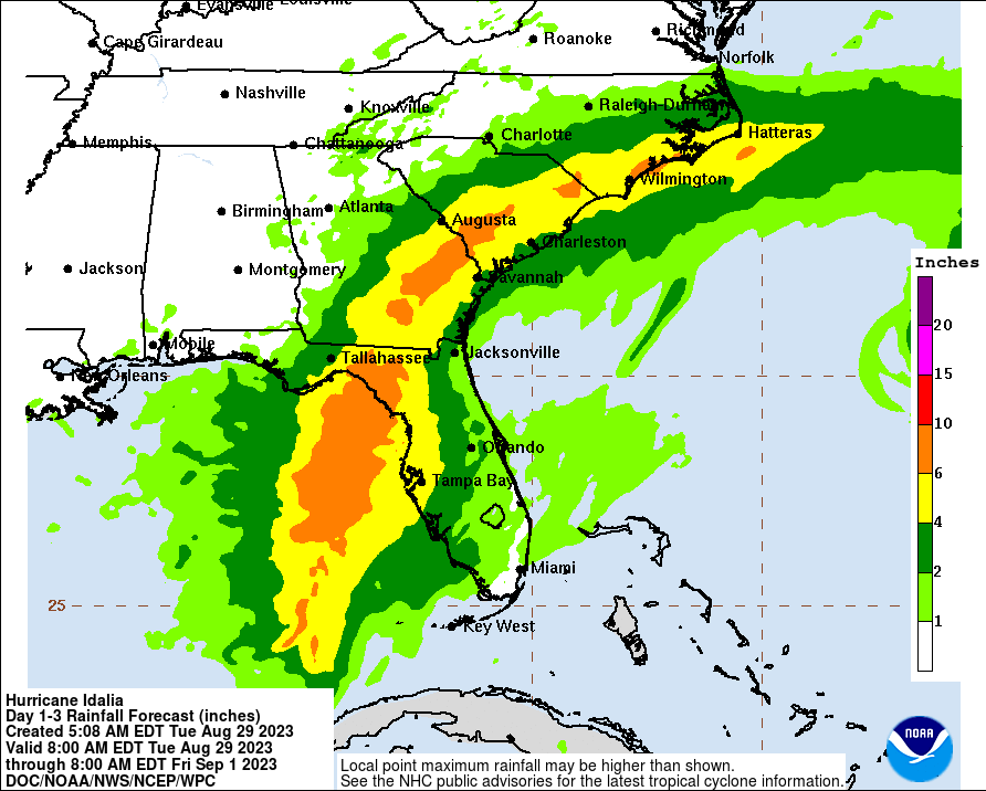
The intensity forecast hasn't changed with the storm expected to intensify rapidly from now through landfall Wednesday around sunrise reaching Cat 3 status with 120 mph winds (and a Cat 4 is still not out of the question, i.e., up to 130 mph winds, as intensity forecasts are still much less accurate than track forecasts). As per the NHC and previous posts, the storm surge risk is major to catastrophic along and to the SE of the track, winds will obviously be catastrophic within 30 miles of landfall and damage will likely be major even inland towards SE GA, rainfall will be torrential with flooding inland (4-8" common within 50-100 miles of the track through the Carolinas), tornadoes are likely along and SE of the track.
Last edited:
Yep, the GFS (AVNI in this graphic) shows that, although it would be pretty weak at that time, and other models show some looping possible, but not all the way back to FL.TWC this morning talking about the GFS showing potential for Idalia to reorg off the coast of FL and loop back, clockwise, toward the SE U.S. One model and too early to give it too much credence, but worth watching.

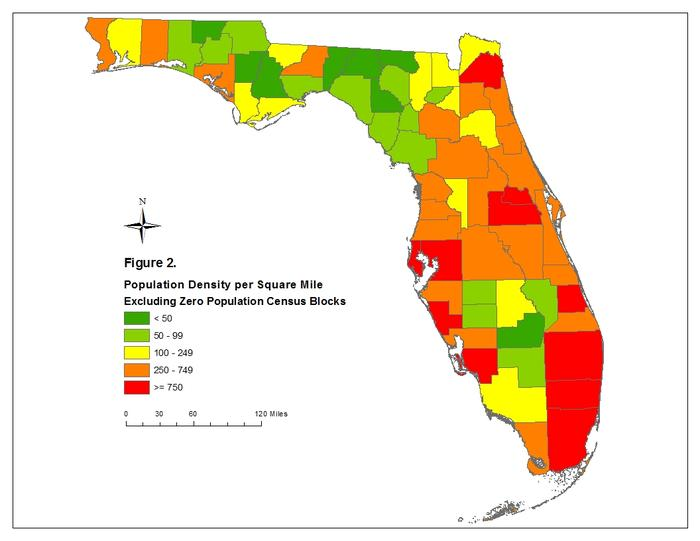
One never wants to "wish" a major hurricane on anyone, but if one thinks about the greater good, it's a bit lucky that this storm looks like it will hit the Big Bend area, the least populated coastal section of Florida, as per the graphic below. Still sucks for them, obviously.
Any idea what it might look like when crosses over southern NC coast, at least as of the current track?
Thanks
Thanks
Idalia will likely be a strong TS with winds in the 60 mph range as it skirts the SE NC coast on Thursday with heavy rains (3-6") and minor storm surge. Nothing the area hasn't seen before, but there will be some impacts.Any idea what it might look like when crosses over southern NC coast, at least as of the current track?
Thanks
Quick update. NHC 11 am advisory is out and Idalia is up to 85 mph and the forecast now calls for the hurricane to be very close to Cat 4 at landfall along the Big Bend area tomorrow morning (no track change), with winds of 125 mph (Cat 4 is 130 mph+) vs. the 120 mph forecast this morning (it keeps increasing).
FORECAST POSITIONS AND MAX WINDS
INIT 29/1500Z 24.6N 84.8W 75 KT 85 MPH
12H 30/0000Z 26.5N 84.6W 90 KT 105 MPH
24H 30/1200Z 29.3N 83.7W 110 KT 125 MPH
36H 31/0000Z 31.8N 81.7W 55 KT 65 MPH...INLAND
48H 31/1200Z 33.5N 78.8W 45 KT 50 MPH...OVER WATER
60H 01/0000Z 34.1N 75.6W 45 KT 50 MPH
72H 01/1200Z 33.8N 73.0W 45 KT 50 MPH
96H 02/1200Z 32.5N 70.2W 45 KT 50 MPH
120H 03/1200Z 32.0N 68.8W 45 KT 50 MPH
https://www.nhc.noaa.gov/refresh/graphics_at5+shtml/093743.shtml?cone#contents
Well im taking the high road..nimbers is on an island now
You drove off the high road pretty quickly there bac.Wrong
Weather for Howard: PARTLY SUNNY HOT 90-95
Lots of focus on Hermine but when she pulls out, we will have temps around 90 or above late week, which may or may not last into Saturday depending on an approaching cold front. There may be more clouds and a shower chance that could keep us in the mid to upper 80s but nonetheless at this time...rutgers.forums.rivals.com
Some rain and some wind tomorrow (area is under a TS watch only), possibly gusting to 30-40 mph, but not a big deal for them and tomorrow morning ought to be fine, if a bit bumpy...
https://forecast.weather.gov/MapClick.php?lon=-81.77519&lat=24.56195
Just an update on this, they had to divert to Miami and land. United doesn’t know when they’ll be able to fly into Key West, but hopefully soon
Good question. You gotta ask Numbers that one.
As far as I’m concerned #s adds value to this board with his weather threads
The few who troll him (you, bac, etc) are just odd and childish. Never understood the trolling of #s
Another quick update with the intermediate 2 pm advisory: Idalia is now up to 90 mph and many of the pros on social media are thinking Idalia will start an RI (rapid intensification) period in about 6-8 hours with 125 mph at landfall possibly being lower than what we'll actually see. Also, several of the models have shifted landfall west by 20-40 miles mor toward Alligator Point (the "top" of the Big Bend). Will be interesting to see if the NHC responds to that by moving the track west - they don't like to zig-zag with forecasts, plus they have access to a helluva lot more data than most of us on line.Quick update. NHC 11 am advisory is out and Idalia is up to 85 mph and the forecast now calls for the hurricane to be very close to Cat 4 at landfall along the Big Bend area tomorrow morning (no track change), with winds of 125 mph (Cat 4 is 130 mph+) vs. the 120 mph forecast this morning (it keeps increasing).
FORECAST POSITIONS AND MAX WINDS
INIT 29/1500Z 24.6N 84.8W 75 KT 85 MPH
12H 30/0000Z 26.5N 84.6W 90 KT 105 MPH
24H 30/1200Z 29.3N 83.7W 110 KT 125 MPH
36H 31/0000Z 31.8N 81.7W 55 KT 65 MPH...INLAND
48H 31/1200Z 33.5N 78.8W 45 KT 50 MPH...OVER WATER
60H 01/0000Z 34.1N 75.6W 45 KT 50 MPH
72H 01/1200Z 33.8N 73.0W 45 KT 50 MPH
96H 02/1200Z 32.5N 70.2W 45 KT 50 MPH
120H 03/1200Z 32.0N 68.8W 45 KT 50 MPH
https://www.nhc.noaa.gov/refresh/graphics_at5+shtml/093743.shtml?cone#contents
And the NHC director was just on TWC agreeing we're going to likely see a RI cycle start soon. One other point he made was that we're going to see Idalia maintain hurricane strength into SE Georgia, meaning areas of interior northern Florida along/near the path into SE GA are likely going to see hurricane force winds and damage, especially to trees, which will mean widespread power outages.
As far as I’m concerned #s adds value to this board with his weather threads
The few who troll him (you, bac, etc) are just odd and childish. Never understood the trolling of #s
Pretty sure it's simply based on their political leanings.
Just an update on this, they had to divert to Miami and land. United doesn’t know when they’ll be able to fly into Key West, but hopefully soon
Have to spend night in Miami. Were Thinking of renting a car and driving….but may not wanna drive in those conditions
I suggest a hybrid auto/aquatic vehicle. It will help when those low lying areas in the Keys get submerged. In all seriousness, be safe and dont take any chances with whatever information you have. Safe travels and keep us updated.Have to spend night in Miami. Were Thinking of renting a car and driving….but may not wanna drive in those conditions

WaterCar ™ The Leaders in Amphibious Vehicle Manufacturing
Reimagine boating with the WaterCar EV, a sleek neighborhood cruiser on land that transforms into an impressive 18-foot boat with a single push of a button. WaterCar Inc is the leader in amphibious boats & vehicles.
 www.watercar.com
I suggest a hybrid auto/aquatic vehicle. It will help when those low lying areas in the Keys get submerged. In all seriousness, be safe and dont take any chances with whatever information you have. Safe travels and keep us updated.
WaterCar ™ The Leaders in Amphibious Vehicle Manufacturing
Reimagine boating with the WaterCar EV, a sleek neighborhood cruiser on land that transforms into an impressive 18-foot boat with a single push of a button. WaterCar Inc is the leader in amphibious boats & vehicles.
Haha, great idea. Thanks, but I’m all good in NJ!
It’s my parents we are talking about, they go to key west every year. They’re currently stuck in Miami and have to spend the night but are expected to be able to fly out tomorrow morning. !
Thanks for the concern and I’ll certainly keep
Ya updated as long as they keep their children updated lol
Have to spend night in Miami. Were Thinking of renting a car and driving….but may not wanna drive in those conditions
Definitely wait it out.
Definitely wait it out.
again, it’s not me. But they definitely are. Already at a bar in Miami so they’re fine, lol. Thanks!
Summary: Idalia is now up to 100 mph and undergoing rapid intensification with 125-130 mph winds looking likely at landfall along the Big Bend area of FL. Major to catastrophic surge and wind damage (with associated major power outages), as well as torrential, flooding rains and scattered tornadoes are on tap for a large swath of FL and into GA/SC/NC tonight through Thursday as per below.
Details:
INIT 29/2100Z 26.1N 84.8W 85 KT 100 MPH
12H 30/0600Z 28.3N 84.5W 100 KT 115 MPH* (likely to be 125 mph at landfall - added by me)
24H 30/1800Z 31.0N 82.9W 75 KT 85 MPH...INLAND
36H 31/0600Z 32.9N 80.2W 50 KT 60 MPH...INLAND
48H 31/1800Z 33.9N 77.1W 45 KT 50 MPH...OVER WATER
60H 01/0600Z 33.8N 74.2W 45 KT 50 MPH
72H 01/1800Z 33.3N 71.8W 45 KT 50 MPH
96H 02/1800Z 32.3N 69.6W 45 KT 50 MPH
120H 03/1800Z 31.7N 69.0W 45 KT 50 MPH
https://www.nhc.noaa.gov/graphics_at5.shtml?start#contents
https://www.americanwx.com/bb/topic/59459-hurricane-idalia/page/30/
https://www.wunderground.com/articl...forecast-florida-georgia-north-south-carolina
Details:
- Idalia is likely to be a major hurricane (>110 mph) with ~125 mph winds (and maybe 130 mph winds, i.e., Cat 4) at landfall, Weds morning around 8-9 am, along the Big Bend FL area (between Steinhatchee and St. Mark's (the "top" of the Big Bend), as the track was nudged 20-25 miles NW with this advisory. More details on the intensity are below.
- The 5 pm NHC advisory shows that Idalia has strengthened from 90 mph to 100 mph over the last 3 hours, which is certainly rapid intensification and it's not done, as the NHC forecast is for the storm to be up to 115 mph by 2 am tomorrow. However, due to the idiosyncracies of the NHC forecasts, the next published point is 2 pm tomorrow, after landfall when the storm is forecast to be at 85 mph - the NHC doesn't publish intermediate forecasts, i.e., at landfall around 8-9 am tomorrow along the Big Bend area, although their discussion does say, "The 12-hour intensity forecast shows a 100-kt (115 mph) major hurricane. It is imperative to realize that Idalia is expected to continue strengthening beyond that time, possibly close to the 110 kt (125 mph) shown in the previous forecast, before the center reaches land."
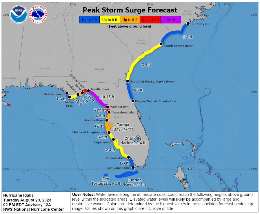
- Catastrophic storm surge is likely along and SE of the storm's track, from landfall down to about Yankeetown (10-15' surge in this area). Major storm surge of 4-7' is still expected as far south as the Tampa/St. Pete Metro area and west of landfall to about Apalachicola and even significant storm surge is predicted (2-4') for much of the GA/SC coasts.
- Catastrophic wind damage is likely along and within 20-30 miles of the track, especially on the SE or stronger side of the tracksomewhat east of the track, even inland 10-20 miles. Major wind damage is likely further than 10-20 miles inland in FL and into SE GA, where Idalia will still be an 85 mph hurricane (weakening of course). Winds will be down to TS strength (~60 mph) by the time the storm reaches SC.
- Major to near total power outages will be widespread from landfall inland about 10-20 miles and major to substantial power outages are likely from there inland to at least SE GA given these forecast winds.
- Torrential rains and flooding will be commonplace in a wide swath along and within maybe 100 miles NW of the track from FL through NC, with 4-8" (and locally more) of rain expected
- Widespread small but dangerous tornadoes will be likely along and SE of the track into SE GA.
INIT 29/2100Z 26.1N 84.8W 85 KT 100 MPH
12H 30/0600Z 28.3N 84.5W 100 KT 115 MPH* (likely to be 125 mph at landfall - added by me)
24H 30/1800Z 31.0N 82.9W 75 KT 85 MPH...INLAND
36H 31/0600Z 32.9N 80.2W 50 KT 60 MPH...INLAND
48H 31/1800Z 33.9N 77.1W 45 KT 50 MPH...OVER WATER
60H 01/0600Z 33.8N 74.2W 45 KT 50 MPH
72H 01/1800Z 33.3N 71.8W 45 KT 50 MPH
96H 02/1800Z 32.3N 69.6W 45 KT 50 MPH
120H 03/1800Z 31.7N 69.0W 45 KT 50 MPH
https://www.nhc.noaa.gov/graphics_at5.shtml?start#contents
https://www.americanwx.com/bb/topic/59459-hurricane-idalia/page/30/
https://www.wunderground.com/articl...forecast-florida-georgia-north-south-carolina
Is the nudge good or bad news for Tampa and more populated areas on the gulf coast?
Assume good?
Assume good?
Pretty sure it's simply based on their political leanings.
If that is true then that is truly the most pathetic thing I have heard.
From Bacs posts I get that he is a trumpy. So he just gives #s sh#t cause #s is liberal??
So you’re saying bac, etc have managed to politicize the friggin weather !?!
Pathetic
Last edited:
yes, good, as the storm will be a bit further away, but the storm surge forecast is unchanged for that area and that's the #1 risk there...Is the nudge good or bad news for Tampa and more populated areas on the gulf coast?
Assume good?
Bac and Numbers have been slapboxing since way before Trump arrived on the political scene.If that is true then that is truly the most pathetic thing I have heard.
From Bach’s posts I get that he is a trumpy. So he just gives #s sh#t cause #s is liberal??
So you’re saying bac, etc have managed to politicize the friggin weather !?!
Pathetic
Not at all.will this have an impact on LSU FSU Sunday night?
Good 100%Is the nudge good or bad news for Tampa and more populated areas on the gulf coast?
Assume good?
Just got off the phone with folks there (Clearwater/Riverview). Almost nothing there now.
Only thing that could be a problem is the moon tide + surge for the bay and rivers from SW winds. Far as I can tell.
Idalia up to 105 mph and Idalia is really showing signs of explosive development now, as an eye has clearly formed, pressure is dropping fairly quickly (down to around 962 mbar now) and the central dense overcast has become nicely symmetrical and has very high cloud tops. This might easily be Cat 4 by landfall (130 mph+ winds), given the near record warm GOM waters and the moist, low-shear environment around the storm now. Scary stuff for the folks along the Big Bend and even down to Cedar Key and for folks up to 50 miles inland along/near the track in interior FL and SE GA.
Last edited:
Scary comment from a pro on AmericanWx: "Any one of these in the outer bands could become tornadic."

Not quite. In addition to surge concerns, see my most recent post. There are very likely to be some small tornadoes on the eastern side of the storm in some of those spiral bands hitting the FL coast now and through the night. And even if no tornadoes, there will likely be some heavy squalls with high winds and torrential rains in those bands. But yes, nowhere near the direct hit it could've been, so Tampa has dodged another bullet.Good 100%
Just got off the phone with folks there (Clearwater/Riverview). Almost nothing there now.
Only thing that could be a problem is the moon tide + surge for the bay and rivers from SW winds. Far as I can tell.
That's an ugly train of cells man! And waay outer edge. 🙏Scary comment from a pro on AmericanWx: "Any one of these in the outer bands could become tornadic."
Idalia up to 110 mph...
Hurricane Idalia Tropical Cyclone Update
NWS National Hurricane Center Miami FL AL102023
1000 PM EDT Tue Aug 29 2023
...IDALIA FORECAST TO BECOME A MAJOR HURRICANE TONIGHT...
...CATASTROPHIC STORM SURGE AND DESTRUCTIVE WINDS LIKELY TOMORROW
MORNING WHERE THE CORE OF IDALIA MOVES INLAND...
NOAA and Air Force Reserve Hurricane Hunter aircraft data indicate
that Idalia has strengthened further. Maximum sustained winds have
increased to 110 mph (175 km/h). The minimum pressure based on
dropsonde data from the aircraft has fallen to 960 mb (28.35
inches).
The National Hurricane Center has begun hourly position and
intensity updates on Idalia. The hourly updates will continue as
long as Idalia's eye is easily trackable in ground-based radar data.
SUMMARY OF 1000 PM EDT...0200 UTC...INFORMATION
----------------------------------------------
LOCATION...27.4N 84.6W
ABOUT 135 MI...215 KM WSW OF TAMPA FLORIDA
ABOUT 205 MI...330 KM S OF TALLAHASSEE FLORIDA
MAXIMUM SUSTAINED WINDS...110 MPH...175 KM/H
PRESENT MOVEMENT...N OR 10 DEGREES AT 18 MPH...29 KM/H
MINIMUM CENTRAL PRESSURE...960 MB...28.35 INCHES
Similar threads
- Replies
- 748
- Views
- 43K
- Replies
- 135
- Views
- 8K
- Replies
- 152
- Views
- 9K
ADVERTISEMENT