
Just saw this on NOAA website WTF. Looks like a tornado watch has been issued for most of central Jersey and parts of PA. Hopefully nothing happens.
Colleges
- American Athletic
- Atlantic Coast
- Big 12
- Big East
- Big Ten
- Colonial
- Conference USA
- Independents (FBS)
- Junior College
- Mountain West
- Northeast
- Pac-12
- Patriot League
- Pioneer League
- Southeastern
- Sun Belt
- Army
- Charlotte
- East Carolina
- Florida Atlantic
- Memphis
- Navy
- North Texas
- Rice
- South Florida
- Temple
- Tulane
- Tulsa
- UAB
- UTSA
- Boston College
- California
- Clemson
- Duke
- Florida State
- Georgia Tech
- Louisville
- Miami (FL)
- North Carolina
- North Carolina State
- Pittsburgh
- Southern Methodist
- Stanford
- Syracuse
- Virginia
- Virginia Tech
- Wake Forest
- Arizona
- Arizona State
- Baylor
- Brigham Young
- Cincinnati
- Colorado
- Houston
- Iowa State
- Kansas
- Kansas State
- Oklahoma State
- TCU
- Texas Tech
- UCF
- Utah
- West Virginia
- Illinois
- Indiana
- Iowa
- Maryland
- Michigan
- Michigan State
- Minnesota
- Nebraska
- Northwestern
- Ohio State
- Oregon
- Penn State
- Purdue
- Rutgers
- UCLA
- USC
- Washington
- Wisconsin
High Schools
- Illinois HS Sports
- Indiana HS Sports
- Iowa HS Sports
- Kansas HS Sports
- Michigan HS Sports
- Minnesota HS Sports
- Missouri HS Sports
- Nebraska HS Sports
- Oklahoma HS Sports
- Texas HS Hoops
- Texas HS Sports
- Wisconsin HS Sports
- Cincinnati HS Sports
- Delaware
- Maryland HS Sports
- New Jersey HS Hoops
- New Jersey HS Sports
- NYC HS Hoops
- Ohio HS Sports
- Pennsylvania HS Sports
- Virginia HS Sports
- West Virginia HS Sports
ADVERTISEMENT
You are using an out of date browser. It may not display this or other websites correctly.
You should upgrade or use an alternative browser.
You should upgrade or use an alternative browser.
OT: Tornado Watch in Central Jersey Till 7pm
- Thread starter Postman_1
- Start date

Just saw this on NOAA website WTF. Looks like a tornado watch has been issued for most of central Jersey and parts of PA. Hopefully nothing happens.

Just so that that jinx forces that rule this board understand, my post above was in no way question the accuracy of the tornado forecast. We are taking this very seriously:

Northern NJ also. Should we get milk and bread?Just saw this on NOAA website WTF. Looks like a tornado watch has been issued for most of central Jersey and parts of PA. Hopefully nothing happens.
That's only effective for snow. Milk melts snow, and bread provides traction.Northern NJ also. Should we get milk and bread?
Thank you for clarifying. What about Pork roll and beer?That's only effective for snow. Milk melts snow, and bread provides traction.
I need a seat belt for my lawn mower. That would be safer in this weather.
Of course it will. We never get spared. My ash trees are asking for trouble. Good luck neighbor!It will hit Lambertville because we are having a birthday party at 6
Do you ash trees look like this?Of course it will. We never get spared. My ash trees are asking for trouble. Good luck neighbor!

Lol, for real. I’m almost all out of ash. Good luck to you!Of course it will. We never get spared. My ash trees are asking for trouble. Good luck neighbor!
They are about as dead as his head coaching career, so there’s some truth in that comparison.Do you ash trees look like this?
Might want to grab some thing some people call Taylor ham. I'm not sure what that is but some pork roll would be great!Thank you for clarifying. What about Pork roll and beer?
I thought we're supposed to have a porn hub links in all weather threads now.
Asian girls? 😮
Asian girls? 😮
Gatorade.I need a seat belt for my lawn mower. That would be safer in this weather.
You're stuck in Chicago and you're calling NJ the garbage state? Got your body armor on?By the way, I haven't been back to the garbage state in 2 years and I am stuck in Chicago waiting on my connecting flight to Newark because of the weather in back there.
Are they busty?
Check the basketball board...
I'd like to make a preemptive respectful plea to the moderators to just delete those posts that are problematic as opposed to locking the entire threads? This tornado watch thread does serve a legitimate interest to all the forum members.I thought we're supposed to have a porn hub links in all weather threads now.
Asian girls? 😮
That's a bad combo. Flying Fish Exit 7 was a Pork Roll Porter. Disgusting. Just beer will do.Thank you for clarifying. What about Pork roll and beer?
Remember, tornadoes are pretty rare around here, but the risk is slightly elevated in a mesoscale convective vortext event like this one. Keep an eye on the radar and the NWS site. Severe t-storms with heavy downpours, gusty winds, and lots of lightning (and hail for some) are far more likely and occurring as we speak...
https://www.weather.gov/phi/
Severe Weather Statement
National Weather Service Mount Holly NJ
444 PM EDT Fri May 20 2022
NJC005-007-029-202115-
/O.CON.KPHI.SV.W.0046.000000T0000Z-220520T2115Z/
Ocean NJ-Camden NJ-Burlington NJ-
444 PM EDT Fri May 20 2022
...A SEVERE THUNDERSTORM WARNING REMAINS IN EFFECT UNTIL 515 PM EDT
FOR NORTHWESTERN OCEAN...CENTRAL CAMDEN AND CENTRAL BURLINGTON
COUNTIES...
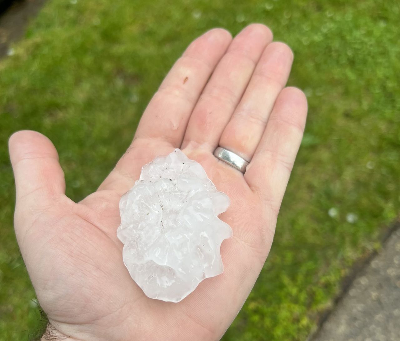
At 443 PM EDT, the public reported a severe thunderstorm producing
ping pong ball sized hail in Cherry Hill. This storm is now located
over Evesham, or 10 miles east of Gloucester City, moving east at 30
mph.
HAZARD...Golf ball size hail and 60 mph wind gusts.
SOURCE...Public.
IMPACT...People and animals outdoors will be injured. Expect hail
damage to roofs, siding, windows, and vehicles. Wind damage
to roofs, siding, trees, and power lines is possible.
https://www.weather.gov/phi/
Severe Weather Statement
National Weather Service Mount Holly NJ
444 PM EDT Fri May 20 2022
NJC005-007-029-202115-
/O.CON.KPHI.SV.W.0046.000000T0000Z-220520T2115Z/
Ocean NJ-Camden NJ-Burlington NJ-
444 PM EDT Fri May 20 2022
...A SEVERE THUNDERSTORM WARNING REMAINS IN EFFECT UNTIL 515 PM EDT
FOR NORTHWESTERN OCEAN...CENTRAL CAMDEN AND CENTRAL BURLINGTON
COUNTIES...
At 443 PM EDT, the public reported a severe thunderstorm producing
ping pong ball sized hail in Cherry Hill. This storm is now located
over Evesham, or 10 miles east of Gloucester City, moving east at 30
mph.
HAZARD...Golf ball size hail and 60 mph wind gusts.
SOURCE...Public.
IMPACT...People and animals outdoors will be injured. Expect hail
damage to roofs, siding, windows, and vehicles. Wind damage
to roofs, siding, trees, and power lines is possible.
Not by choice, just my connecting airport.You're stuck in Chicago and you're calling NJ the garbage state? Got your body armor on?
Bust as usual and tge models have horrific mid range and even 24 hours out
Im skeptical of tomorrows sun and heat given how atrocious the models performed this week
Im skeptical of tomorrows sun and heat given how atrocious the models performed this week
Bust as usual and tge models have horrific mid range and even 24 hours out
Im skeptical of tomorrows sun and heat given how atrocious the models performed this week
Accuweather downgraded from 97F to 90F for Sunday. Actually Partly Sunny, Hot and Asian, er, I mean Humid.
I had no idea what the hell some of you were talking about.
Now I do.😎
And as to the question did I click on the link…

Now I do.😎
And as to the question did I click on the link…
So what thread is it?Accuweather downgraded from 97F to 90F for Sunday. Actually Partly Sunny, Hot and Asian, er, I mean Humid.
I agree. Probably higher 80s reach low 90s in our area. I saw some predictions of 97 - that’s July and August heat wave sh$t.Bust as usual and tge models have horrific mid range and even 24 hours out
Im skeptical of tomorrows sun and heat given how atrocious the models performed this week
Great weather for Sundays Patriots baseball game.I agree. Probably higher 80s reach low 90s in our area. I saw some predictions of 97 - that’s July and August heat wave sh$t.
So what thread is it?
Not sure. It was read to me this morning after I asked why @MrsScrew was laughing hysterically at 8AM.
She was laughing at Hott, Busty, Asian women?Not sure. It was read to me this morning after I asked why @MrsScrew was laughing hysterically at 8AM.
Are you going? They always did everything first class now they have a Yankees affiliate. It’s great for our area.Great weather for Sundays Patriots baseball game.
We go to about 4 games a season. My wife, son, her parents and I are going. They are having a day for vets and a few different ceremonies. My wife's father is a vet, and the Patriots are giving free tickets to vets that day. The Patriots are also giving family members $5.00 upper box seats.Are you going? They always did everything first class now they have a Yankees affiliate. It’s great for our area.
Why would you call today's forecast a bust? A tornado watch just means that tornadoes are possible, so having a tornado watch, but no tornadoes isn't a bust, per se, especially when all of the other impacts were generally realized. The area had 1/4-1/2" of rain everywhere, with up to 1" common in many areas and over 1" in localized areas and severe t-storms hit large parts of the area with significant hail (especially in SNJ, where 2" hailstones were reported) and very gusty winds, with some downed trees/poles and several thousand power outages.Bust as usual and tge models have horrific mid range and even 24 hours out
Im skeptical of tomorrows sun and heat given how atrocious the models performed this week
https://www.nj.com/weather/2022/05/...d-as-strong-thunderstorms-hit-the-region.html
I do agree with your skepticism on tomorrow's heat, though, as most of the models are now showing max temps tomorrow in the low 90s for the urban corridor and upper 80s well NW of 95 and, of course, the low 80s near the coast with sea breezes...and temps barely getting to 90F on Sunday for the warmest locations near/along the 95 corrdor from Wilmington to Trenton.
Why would you call today's forecast a bust? A tornado watch just means that tornadoes are possible, so having a tornado watch, but no tornadoes isn't a bust, per se, especially when all of the other impacts were generally realized. The area had 1/4-1/2" of rain everywhere, with up to 1" common in many areas and over 1" in localized areas and severe t-storms hit large parts of the area with significant hail (especially in SNJ, where 2" hailstones were reported) and very gusty winds, with some downed trees/poles and several thousand power outages.
https://www.nj.com/weather/2022/05/...d-as-strong-thunderstorms-hit-the-region.html
I do agree with your skepticism on tomorrow's heat, though, as most of the models are now showing max temps tomorrow in the low 90s for the urban corridor and upper 80s well NW of 95 and, of course, the low 80s near the coast with sea breezes...and temps barely getting to 90F on Sunday for the warmest locations near/along the 95 corrdor from Wilmington to Trenton.
Jeez ...no reason to show the "after" shot from the other day.
Maybe give it a rest. While there's oodles of comedy gold in that event, it's just getting threads locked and deleted, which serves nobody.Jeez ...no reason to show the "after" shot from the other day.

Maybe give it a rest. While there's oodles of comedy gold in that event, it's just getting threads locked and deleted, which serves nobody.
Well, then stop teeing it up to perfection. I didn't even want to rag on you.
Similar threads
- Replies
- 144
- Views
- 5K
ADVERTISEMENT