
You remember I said this would happen a few years agoget ready for alarmist talk....look how many are already falling for it...its will be the new political talking point going forward
ny times was pushing it and Hillary delivered with assinine comments today
Colleges
- American Athletic
- Atlantic Coast
- Big 12
- Big East
- Big Ten
- Colonial
- Conference USA
- Independents (FBS)
- Junior College
- Mountain West
- Northeast
- Pac-12
- Patriot League
- Pioneer League
- Southeastern
- Sun Belt
- Army
- Charlotte
- East Carolina
- Florida Atlantic
- Memphis
- Navy
- North Texas
- Rice
- South Florida
- Temple
- Tulane
- Tulsa
- UAB
- UTSA
- Boston College
- California
- Clemson
- Duke
- Florida State
- Georgia Tech
- Louisville
- Miami (FL)
- North Carolina
- North Carolina State
- Pittsburgh
- Southern Methodist
- Stanford
- Syracuse
- Virginia
- Virginia Tech
- Wake Forest
- Arizona
- Arizona State
- Baylor
- Brigham Young
- Cincinnati
- Colorado
- Houston
- Iowa State
- Kansas
- Kansas State
- Oklahoma State
- TCU
- Texas Tech
- UCF
- Utah
- West Virginia
- Illinois
- Indiana
- Iowa
- Maryland
- Michigan
- Michigan State
- Minnesota
- Nebraska
- Northwestern
- Ohio State
- Oregon
- Penn State
- Purdue
- Rutgers
- UCLA
- USC
- Washington
- Wisconsin
High Schools
- Illinois HS Sports
- Indiana HS Sports
- Iowa HS Sports
- Kansas HS Sports
- Michigan HS Sports
- Minnesota HS Sports
- Missouri HS Sports
- Nebraska HS Sports
- Oklahoma HS Sports
- Texas HS Hoops
- Texas HS Sports
- Wisconsin HS Sports
- Cincinnati HS Sports
- Delaware
- Maryland HS Sports
- New Jersey HS Hoops
- New Jersey HS Sports
- NYC HS Hoops
- Ohio HS Sports
- Pennsylvania HS Sports
- Virginia HS Sports
- West Virginia HS Sports
ADVERTISEMENT
You are using an out of date browser. It may not display this or other websites correctly.
You should upgrade or use an alternative browser.
You should upgrade or use an alternative browser.
OT: Updated Thread: Stormy Monday evening (8/7), including tornado watch for some
- Thread starter RU848789
- Start date

So I go the gym really early and none of the locals 2,4,5 or 7 mentioned this possibility of a storm for my area.
Maybe something changed, which is always a possibility in the summer, but this morning all they talked about was a possibility for something north and west of the City.
Maybe something changed, which is always a possibility in the summer, but this morning all they talked about was a possibility for something north and west of the City.
Everything changes in the summer with the atmosphere being what it is with this heat and humidity. The potential is pretty much everywhere and sometimes you hit the unfortunate lottery like we did in my area today.So I go the gym really early and none of the locals 2,4,5 or 7 mentioned this possibility of a storm for my area.
Maybe something changed, which is always a possibility in the summer, but this morning all they talked about was a possibility for something north and west of the City.
So I go the gym really early and none of the locals 2,4,5 or 7 mentioned this possibility of a storm for my area.
Maybe something changed, which is always a possibility in the summer, but this morning all they talked about was a possibility for something north and west of the City.
This is what im talking about..yet Numbers will always defend the forecasters
Well, like @RUPete and I said previously…we know there can be changes in the summer but not one mentioned something could happen around here?This is what im talking about..yet Numbers will always defend the forecasters
Just once, could you not try to pollute a thread with political crap? There have been no derailing posts made in this thread until yours. It's going to be moderately hot - it happens, it's summer.get ready for alarmist talk....look how many are already falling for it...its will be the new political talking point going forward
ny times was pushing it and Hillary delivered with assinine comments today
I’ll admit I didn’t think today would be a severe weather day. Was surprised when the watch went up, and even moreso with the explosive storm development in PA. The PWATs must have been off the charts with the intensity of some of these downpours.
That's almost unbelievable. Not saying you're making things up, but if that's correct, there was zero reason for them to all miss so badly, since the NWS at 4 am (first excerpt below) clearly highlighted the region-wide risk for severe storms and they and the local TV mets all could see the same models showing the potential for severe storms in the afternoon. Even the 4 pm Monday NWS discussion (2nd excerpt below) mentioned possible severe storms for this afternoon.So I go the gym really early and none of the locals 2,4,5 or 7 mentioned this possibility of a storm for my area.
Maybe something changed, which is always a possibility in the summer, but this morning all they talked about was a possibility for something north and west of the City.
National Weather Service Mount Holly NJ
401 AM EDT Tue Jul 25 2023
NEAR TERM /THROUGH TONIGHT/...
The mid to late morning hours are expected to be relatively
uneventful weatherwise, with scattered cumulus developing. The wind
should settle mainly into the southwest and south around 5 to 10 MPH.
A more robust mid level short wave was located over eastern Indiana,
western Ohio and vicinity early this morning. The feature will
progress to the east. Its axis is forecast to pass overhead this
evening.
The approaching short wave and the increasing moisture in the
southerly flow will likely result in the development of another
round of showers and thunderstorms for this afternoon into this
evening. Mixed layer CAPE values in the 1500 to 2500 J/kg range
should provide an environment conducive for organized convection,
producing strong wind gusts and hail. The Storm Prediction Center
has highlighted our region for possible severe weather today.
Precipitable water values are forecast to approach 2 inches,
especially from the Interstate 95 Corridor southeastward. Therefore,
locally heavy rain may occur.
National Weather Service Mount Holly NJ
344 PM EDT Mon Jul 24 2023
NEAR TERM /THROUGH TUESDAY/...
On Tuesday, the upper H5 trough will start to push through the
area, reaching wrn PA during the morning and arriving over ern
PA by evening. More shortwaves and good daytime heating will
create showers/tstms by afternoon. A line of activity could
develop and move W to E thru the afternoon and evening. The most
recent Day2 outlook has increased the Delmarva areas into the
Slight risk category while other areas remain in Marginal risk.
Wind and hail are the primary threats for Tuesday.
PWATS were 2" (precipitatable water levels), along with fairly high CAPE (Convective Available Potential Energy) levels of 1500-2500 J/kg, which, combined, is a pretty potent setup (lots of "fuel") for storms and the approaching shortwave provided the spark to set the storms off. See the AFD from this morning, which I just posted. I didn't post about it this morning, because I generally focus on snow and tropical systems and often only post about t-storms when things are more imminent (especially given how hard they are to predict).I’ll admit I didn’t think today would be a severe weather day. Was surprised when the watch went up, and even moreso with the explosive storm development in PA. The PWATs must have been off the charts with the intensity of some of these downpours.
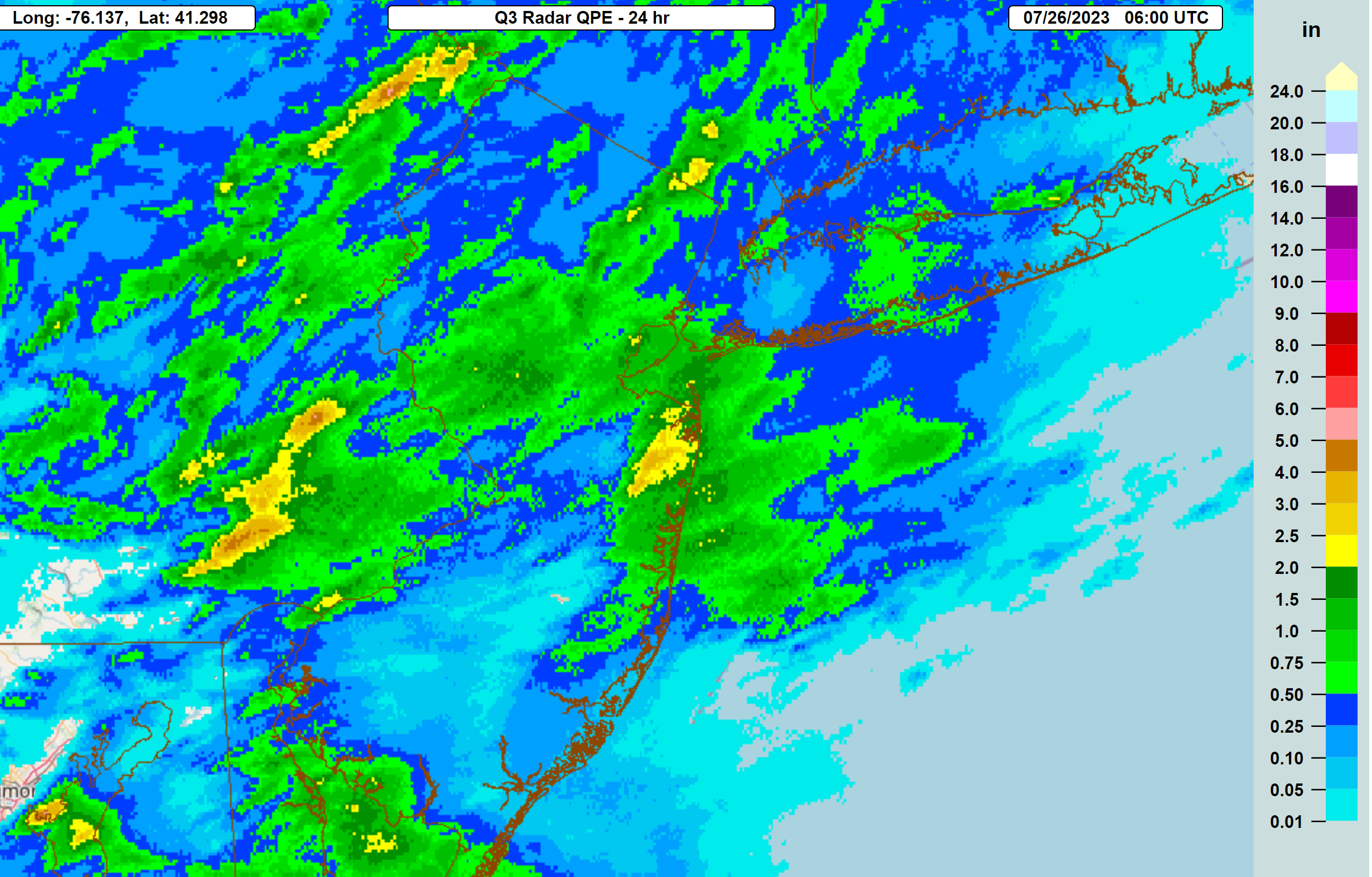
Here's the radar estimated rainfall for the 24 hours starting around 2 am Monday. This time most of CNJ and the Jersey Shore were the jackpots, but even there one can see the huge local gradients in rainfall, with 2-3" in a decent patch of coastal Monmouth, but only <0.1" about 5 miles east of there (from about Tinton Falls to Colts Neck). Once again that shows how it's literally impossible to predict where and when the big storms and heavy precip will hit in mesoscale convective events.
Was hot today, but tomorrow will be brutal with temps in the mid/upper 90s for most and heat indices near 105F. Could be an isolated shower or two, but mostly sunny and hot. Hot again Saturday, with the heat breaking mid/late afternoon into the evening with a cold front, which could bring some severe weather. After that, gorgeous for several days with comfortable humidity.
Today's severe weather threat never really materialized for anyone south of 78, but for areas north of there up through the 84 corridor, some big storms did hit with 1-2" of rain and scattered wind damage.
Today's severe weather threat never really materialized for anyone south of 78, but for areas north of there up through the 84 corridor, some big storms did hit with 1-2" of rain and scattered wind damage.
Storms are coming for some, but impossible to predict exactly where and when. Cold front is approaching a very juicy, somewhat unstable air mass, which is sparking off t-storms in EPA and SEPA near Philly right now (under severe t-storm warning now) and these will migrated into much of NJ - could be some high winds and lots of lightning, so be careful out there. And then we have gorgeous weather the next 4-5 days with comfortable humidity...
https://www.weather.gov/phi/
https://www.weather.gov/phi/
Sea Girt on the other hand…🤷♂️Spring Lake says, “Not today Mother Nature. Not today.”
See something from the southwest in the distance.
Last edited:
Dont think we will be seeing balloons flying over our house tonight from the festival.Just got pounded in southern hunterdon. Two big limbs down, no idea how we still have power. That was nuts.
Haven't seen storms like this year around here since the summer of 2012.
Was it all liquid, or some solid? Looks like we're on deck.Just got pounded in southern hunterdon. Two big limbs down, no idea how we still have power. That was nuts.
Haven't seen storms like this year around here since the summer of 2012.
Sorry, you're likely up next...the severe storms missed to our south by about 2 miles - nothing here...Spring Lake says, “Not today Mother Nature. Not today.”
Scattered storms were predicted for last night and the overnight - you just happened to get hit, while most didn't. Will you ever learn that the science is not advanced enough to predict exactly where and when these kinds of mesoscale storms and showers will strike?We had a half inch last night with storm not predicted and more rain this morning not predicted
Looking out my window…Sorry, you're likely up next...the severe storms missed to our south by about 2 miles - nothing here...
Still looks a little south to me.Sea Girt on the other hand…🤷♂️
See something from the southwest in the distance.
Sea Girt on the other hand…🤷♂️
See something from the southwest in the distance.
Sorry, you're likely up next...the severe storms missed to our south by about 2 miles - nothing here...
Looking out my window…
Still looks a little south to me.

In a blink of an eye. It’s wild out here now.😱
Last edited:
Looks like a wild storm - stay safe...
In a blink of an eye. It’s wild out here now.😱
Left as fast as it came in. My neighbor an I see something else in the distance but that looks a little south.Looks like a wild storm - stay safe...
It was intense here in OC I haven’t seen wind like that since Sandy. Poor Timing too as it was Night In Venice. Lots of people out in the bay
We have had 10-11 inches of rain in the last 38 days. Recorded rainfall on 23 out of those 38 days
We were having dinner at The Whiskey Bar in Brielle and saw the dark skies to South. We asked for the check, and waitress was slow to bring it. Came down in buckets and the window next to our table in patio room sprung a leak. We stayed for dessert, and it cleared quickly. I know it's the Whiskey Bar, but nearly everything on the menu is infused with whiskey. It was pretty good.Left as fast as it came in. My neighbor an I see something else in the distance but that looks a little south.
The old Simko’s?We were having dinner at The Whiskey Bar in Brielle and saw the dark skies to South. We asked for the check, and waitress was slow to bring it. Came down in buckets and the window next to our table in patio room sprung a leak. We stayed for dessert, and it cleared quickly. I know it's the Whiskey Bar, but nearly everything on the menu is infused with whiskey. It was pretty good.


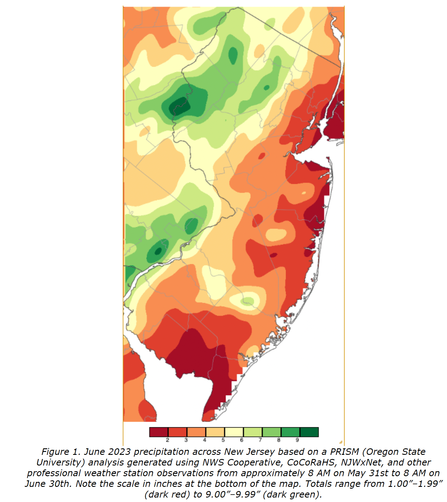
Did you have about 4-5" in June? Just curious how accurate the NJ State Climatologist report/graphic for June precip is. For anyone interested, they do a very nice job summarizing and detailing the climate/weather for each month across the state (temps/precip vs. avg, specific storms, severe weather, air quality, etc.). The precip map shows how widely varying the precip was across the state in June, which is pretty unusual, with widespread 5-10" across most locations north of 78/W of 287 (from 78 to NY), but only 1-4" across much of NJ along/SE of the Turnpike. I'm sure July is going to show some crazy high numbers for some spots. And while June was fairly cool, the first half of 2023 was the 3rd warmest first half of the year state-wide.We have had 10-11 inches of rain in the last 38 days. Recorded rainfall on 23 out of those 38 days
https://www.njweather.org/content/s...e-june-2023-recap-plus-first-half-2023-review
Last edited:
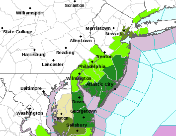
Could be some strong storms this evening (generally from about 5-6 pm through 11 pm), especially in EPA and western NJ, with a tornado watch in effect until 11 pm from about Tuckerton through Mercer County and up through Warren County and all points west of that line (counties in yellow below).
This doesn't mean we're going to see any tornadoes, but conditions are at least somewhat favorable for severe storms and possible tornadoes in that area. Even if no tornadoes materialize, some of the storms will likely produce high winds, torrential rains in spots, lightning and hail. Keep an eye on the radar.
https://www.weather.gov/phi/
Boy loves his long threads, don’t he?🕺
Well, experiencing strong thunderstorms in the heart of the summer is something new for us to deal with!
I align myself with those who insist there be different threads for new weather events. I don't have the patience to sift through multiple pages of outdated posts to try and find where the new topic begins.
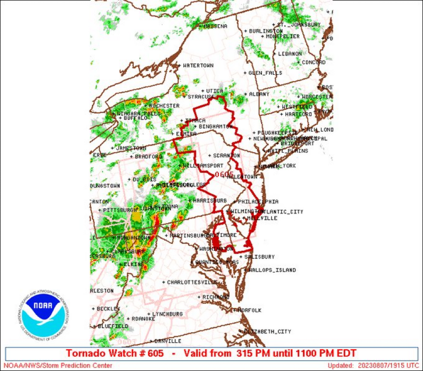
The NWS has extended the tornado watch further east to include Ocean, Monmouth, Middlesex, Somerset, Morris, and Sussex, which were not in the original watch, plus a severe t-storm watch is now up for the entire Philly-NJ-NYC region and a host of severe t-storm warnings are in place for ongoing/incoming severe t-storms in SWNJ, Philly/EPA, and western NJ and these might eventually include NENJ/NYC. Serious line of storms...
I've never understood that - I assume everyone simply goes to the last, most recent post in a thread like this, which takes nanoseconds.I align myself with those who insist there be different threads for new weather events. I don't have the patience to sift through multiple pages of outdated posts to try and find where the new topic begins.
Just lazy - less work for me, plus half the threads on the first page are longer than this one...Boy loves his long threads, don’t he?🕺
Similar threads
- Replies
- 87
- Views
- 4K
- Replies
- 131
- Views
- 5K
ADVERTISEMENT
ADVERTISEMENT