
Colleges
- American Athletic
- Atlantic Coast
- Big 12
- Big East
- Big Ten
- Colonial
- Conference USA
- Independents (FBS)
- Junior College
- Mountain West
- Northeast
- Pac-12
- Patriot League
- Pioneer League
- Southeastern
- Sun Belt
- Army
- Charlotte
- East Carolina
- Florida Atlantic
- Memphis
- Navy
- North Texas
- Rice
- South Florida
- Temple
- Tulane
- Tulsa
- UAB
- UTSA
- Boston College
- California
- Clemson
- Duke
- Florida State
- Georgia Tech
- Louisville
- Miami (FL)
- North Carolina
- North Carolina State
- Pittsburgh
- Southern Methodist
- Stanford
- Syracuse
- Virginia
- Virginia Tech
- Wake Forest
- Arizona
- Arizona State
- Baylor
- Brigham Young
- Cincinnati
- Colorado
- Houston
- Iowa State
- Kansas
- Kansas State
- Oklahoma State
- TCU
- Texas Tech
- UCF
- Utah
- West Virginia
- Illinois
- Indiana
- Iowa
- Maryland
- Michigan
- Michigan State
- Minnesota
- Nebraska
- Northwestern
- Ohio State
- Oregon
- Penn State
- Purdue
- Rutgers
- UCLA
- USC
- Washington
- Wisconsin
High Schools
- Illinois HS Sports
- Indiana HS Sports
- Iowa HS Sports
- Kansas HS Sports
- Michigan HS Sports
- Minnesota HS Sports
- Missouri HS Sports
- Nebraska HS Sports
- Oklahoma HS Sports
- Texas HS Hoops
- Texas HS Sports
- Wisconsin HS Sports
- Cincinnati HS Sports
- Delaware
- Maryland HS Sports
- New Jersey HS Hoops
- New Jersey HS Sports
- NYC HS Hoops
- Ohio HS Sports
- Pennsylvania HS Sports
- Virginia HS Sports
- West Virginia HS Sports
ADVERTISEMENT
You are using an out of date browser. It may not display this or other websites correctly.
You should upgrade or use an alternative browser.
You should upgrade or use an alternative browser.
OT: Updated Thread: Stormy Monday evening (8/7), including tornado watch for some
- Thread starter RU848789
- Start date

I’m down in LBI on vacation this week. I’m hoping things don’t get too bad tonight. T Storms can be pretty bad down here. I remember being down here about 6 or 7 years ago and got hit , lost power and some of the streets were flooded.
This storm looks like it's going to engulf all of NJ. Impressive storm.Picture = 1000 words...
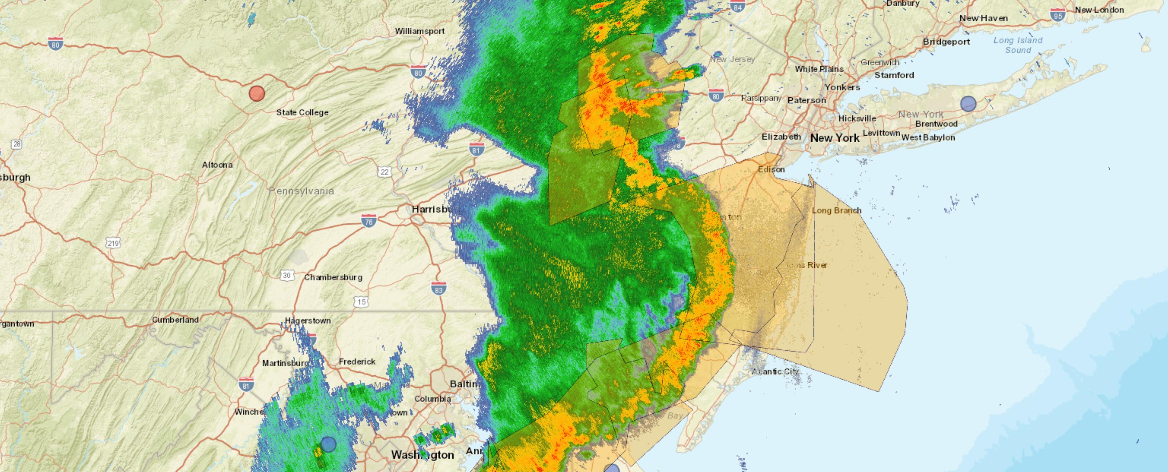
Wow the HRRR was right, convection collapsed once into NJ, at least north of trenton. Shocked, this was the most synoptic severe weather setup in the region the past 10 years. Most discounted the short range models.
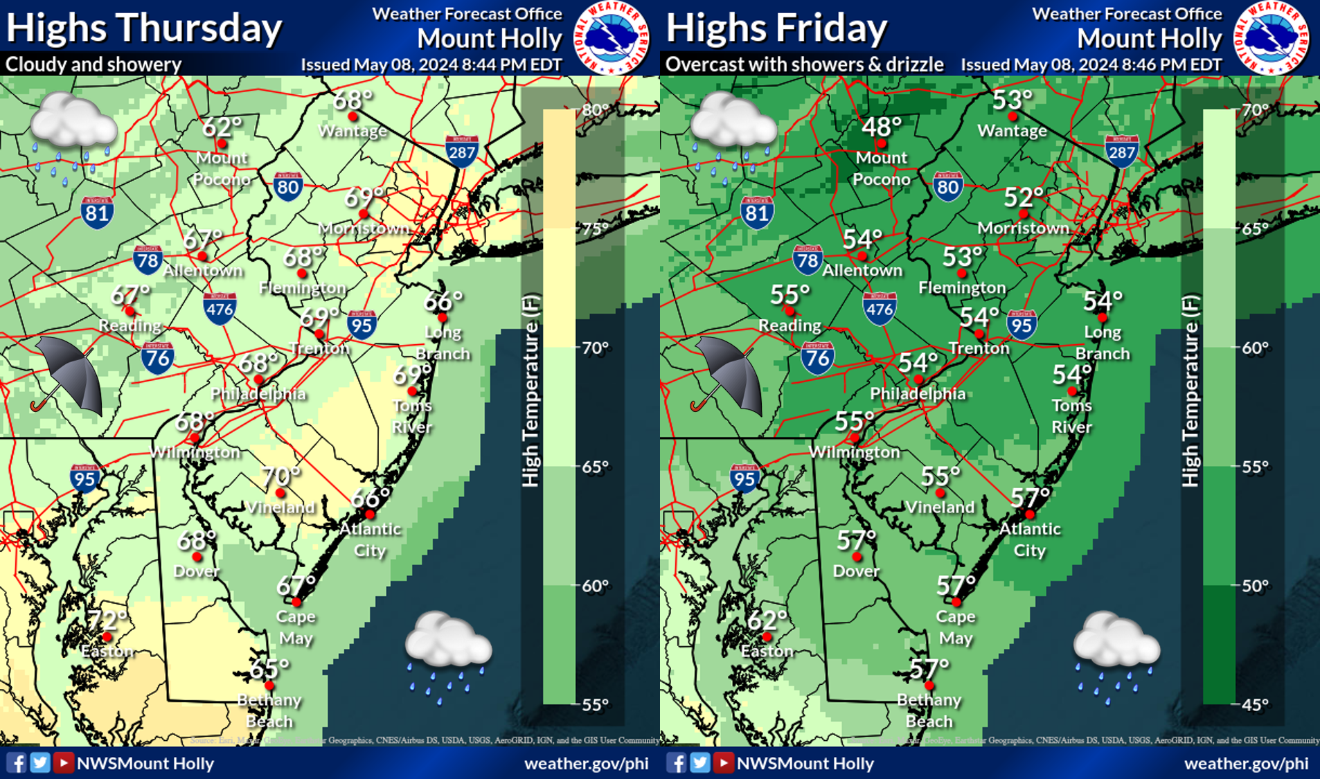
The further east one goes, the weaker the storm line should be, at least based on the sun now being just about down, reducing atmospheric energy and instability, but that doesn't mean you won't get rocked a bit.I’m down in LBI on vacation this week. I’m hoping things don’t get too bad tonight. T Storms can be pretty bad down here. I remember being down here about 6 or 7 years ago and got hit , lost power and some of the streets were flooded.
Yep, the line is clearly weakening, even south of Trenton - not a complete surprise, but fascinating to see...Wow the HRRR was right, convection collapsed once into NJ, at least north of trenton. Shocked, this was the most synoptic severe weather setup in the region the past 10 years. Most discounted the short range models.
As many thought..totally falling apart as it went through my area..just some rumbles and light rain
Hrrr for the win
Hrrr for the win
Wow the HRRR was right, convection collapsed once into NJ, at least north of trenton. Shocked, this was the most synoptic severe weather setup in the region the past 10 years. Most discounted the short range models.
Those paying attention knew
I spent this past week (Monday thru Sunday) finishing the Pennsylvania section of the Appalachian Trail, ending at the Delaware Water Gap. Seven straight days of hiking. Just got back to NC last night. Lucked out, missing this wicked weather, both hiking and driving back. Was up on many very exposed rocky ridges, almost daily in PA. And those effin' rocks will not be missed.
So, I guess the models don't always suck?As many thought..totally falling apart as it went through my area..just some rumbles and light rain
Hrrr for the win
no but the forecasters sure hyped up something that those in the know knew was a distinct possibility
Lol the HRRR has been atrocious this summer and scored a rare coup. It’s like using the ICON for winter storms.Those paying attention knew
There was a marine layer of SSE winds keeping low level clouds in the areas and drawing in more stable air that the complex couldn’t overcome.
The front edge of the strong bow echo simply collapsed once it hit western Monmouth. It's barely raining here.
But the lightning in Spring Lake is spectacular.The front edge of the strong bow echo simply collapsed once it hit western Monmouth. It's barely raining here.
Two things:Just lazy - less work for me, plus half the threads on the first page are longer than this one...
1. At least you finally admit it.🙂
2. Those other threads are at least about something specific…
New storm, new thread. Was that not our gentlemen’s agreement?😉
It was...for the fairly infrequent winter and tropical storms that might impact our area. I generally don't do severe weather, as others have often started threads on that, but nobody seems to be doing that this summer, so I stepped in. Too much extra effort to create new threads, plus we can have t-storms almost every day for stretches, as we just saw and having 30 new t-storm threads seems excessive to me. Motion denied. :>)Two things:
1. At least you finally admit it.🙂
2. Those other threads are at least about something specific…
New storm, new thread. Was that not our gentlemen’s agreement?😉
“But I change the title!”I align myself with those who insist there be different threads for new weather events. I don't have the patience to sift through multiple pages of outdated posts to try and find where the new topic begins.
When there is the possibility of a big one happening I think it’s fair to start a new one for the community for at the bare minimum of the safety aspect of it.
This is coming from someone who greatly appreciates what the OP (and others) do for us on this subject matter.🫡👍
But that’s my point.It was...for the fairly infrequent winter and tropical storms that might impact our area. I generally don't do severe weather, as others have often started threads on that, but nobody seems to be doing that this summer, so I stepped in. Too much extra effort to create new threads, plus we can have t-storms almost every day for stretches, as we just saw and having 30 new t-storm threads seems excessive to me. Motion denied. :>)
The severe weather (or the possibility of it) update IS an important thread to have it’s own thing.
You’re good at it. Ignore the peanut galley and give us the 411. It’s really appreciated, even if the forecast falls flat or doesn’t perform as expected.
The NWS and SPC highlighted the decreasing risk of severe weather as one crossed PA into NJ and especially towards the NJ coast. This graphic summarized it well. However, once the severe storms were on the ground and into NJ it would've been foolhardy to not put the watches and warnings up. Better forewarned and minimal impact than not warned at all and major impact, especially when the warning timeframe was less than an hour or two.Lol the HRRR has been atrocious this summer and scored a rare coup. It’s like using the ICON for winter storms.
There was a marine layer of SSE winds keeping low level clouds in the areas and drawing in more stable air that the complex couldn’t overcome.
That’s just a Tuesday on a barrier islandI’m down in LBI on vacation this week. I’m hoping things don’t get too bad tonight. T Storms can be pretty bad down here. I remember being down here about 6 or 7 years ago and got hit , lost power and some of the streets were flooded.
Was just posting about this -Flash flood swept 3 cars away. Drivers were not trying to drive through flood water. Firefighters were nearby on another call and it happened in front of them. Almost 7” in 45 min. I was just in the area Thursday in a creek taking pictures of a covers bridge. Tragic and scary how fast water can rise.
Think something similar happened in the summer of 2000 or 01 up in Sussex - dams giving out compounded it. Tstorm just stalled. Incredibly scary stuff.
Think something similar happened in the summer of 2000 or 01 up in Sussex - dams giving out compounded it. Tstorm just stalled. Incredibly scary stuff.
Don't forget, was it Sept. 99, when Floyd swept through.
Similar threads
- Replies
- 131
- Views
- 5K
- Replies
- 62
- Views
- 4K
- Replies
- 608
- Views
- 21K
- Replies
- 771
- Views
- 26K
ADVERTISEMENT
ADVERTISEMENT