Title from 1/31 through 2/11: OT: Winter Storm Mon Night/Tuesday (2/12-13) - HUGE Uncertainty on Outcome
Been discussing this event in the pattern thread, linked below, for a few days and now that we're only 4-4.5 days away and have some indication that this could be a minor snowfall, after some rain for 95/coast and a moderate to significant snowfall N of 78 and especially NW of 80/287 (after some initial rain), figured a thread was worthwhile. Like many storms in the Philly-NJ-NYC region, uncertainty on precip amounts, precip type, timing of precip and any changeover from rain to snow, as well as uncertainty on how much snow that falls will actually accumulate, is pretty high this far out, but it's probably even greater than usual given what we're seeing in the models, so far.
https://rutgers.forums.rivals.com/t...a-possible-colder-and-snowier-pattern.273234/
I don't think anyone has a handle on a storm that models are showing could give New Brunswick, for example, anything from all rain to mostly rain with an inch or two of snow/slush to moderate rain then a few inches of snow to some rain and several inches of snow (with 6" or more on the table if the GFS is right), with probably mostly rain followed by an inch or two of snow being most probable. Like most storms around here, it's looking like NW areas are most favored for snow (colder temps) with 95/coast most favored for mostly rain (warmer), but the track and intensity of the storm could easily shift 100+ miles, such that huge changes are still possible and it should also be noted that some models are showing heavy, high intensity precip (over 1" of QPF - total precip on a liquid basis) while others are showing much less precip (<1/2" QPF).
I could probably stop right here and just say to check back in in 2 days when we'll hopefully have a consensus, but that's not how I roll, lol. So, below is a summary of what we've seen for yesterday's 12Z models (using 7 am data inputs) and tonight's 0Z models (using 7 pm data inputs). Overall we kind of have 2 camps: the GFS/Euro with significant snowfall for much of our area vs. the CMC/UK with minor to no snowfall for most of our area (and much less precip overall). Definitely not worth attaching all the snowfall maps as the model runs will change - maybe as we get closer.
Still, so much can change, but the likelihood of a complete miss is pretty low. However, having confidence in a mostly/all rain vs. mostly/all snow or somewhere in between (and where the heaviest precip/snow/rain is) outcome is extremely low at this point. It's also likely that even if there is significant snow falling from the sky, it could have a hard time accumulating with temps likely at or just above 32F and some of the snow falling during the day, unless intensity is fairly high. Fortunately, with the main pieces of energy now being over land (they were over the Pacific or far north with sparse data inputs leading to higher uncertainty) and given that we're closer to the event, when the error bars shrink, hopefully we'll start seeing more consensus by tomorrow night or Saturday. For now, stay tuned.
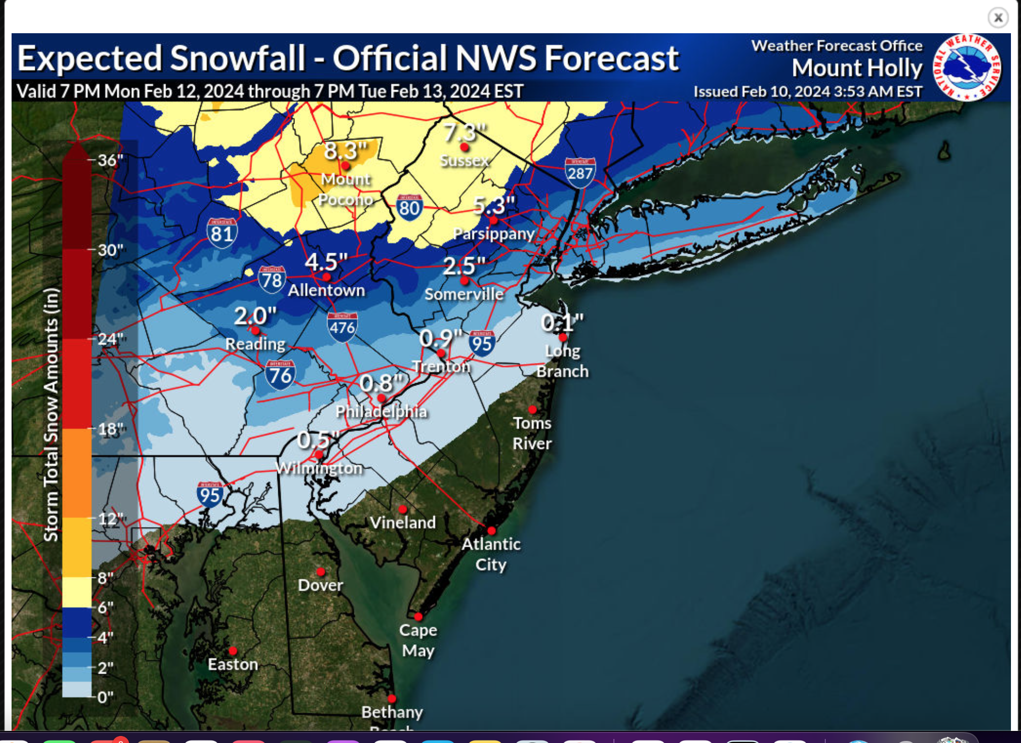
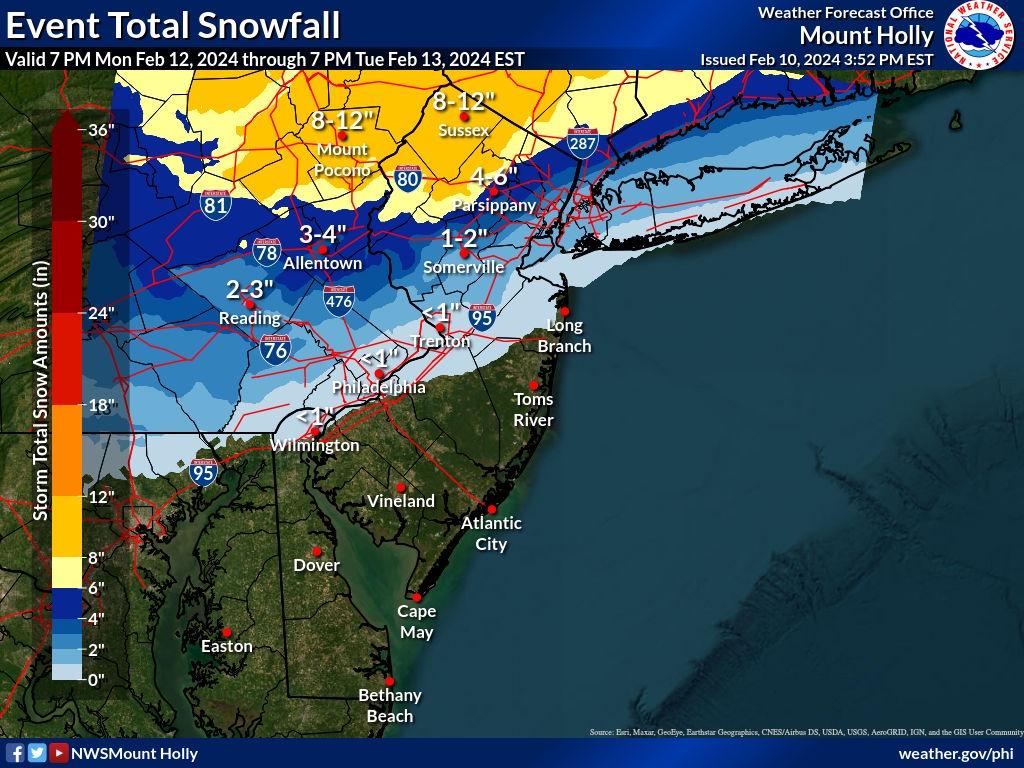
Not sure what the NWS is going to do with the current wildly varying model depictions of the storm, but they did at least move towards a possible snowier outcome with their 4 pm discussion today, after dismissing snowfall chances yesterday morning. Specifically, this morning, they were only calling for a chance of snow well NW of 95 with rain for 95/coast, but as per the part in bold, they're acknowledging that a plowable snow is possible all the way down to 95 (the fall line). Below are the usual links to the NWS and the AmericanWx thread and I also included a link to a fantastic summary of the synoptic setup by brooklynwx (a well-respected met) highlighting the things that might still go wrong, but showing that some accumulating snow for even 95/coast is possible.
https://www.weather.gov/phi/
https://www.americanwx.com/bb/topic...m-potential-rain-snow-mix-on-feb-1314/page/2/
https://www.americanwx.com/bb/topic/59981-february-2024/?do=findComment&comment=7200829
LONG TERM /SUNDAY NIGHT THROUGH THURSDAY/...
Unsettled weather on tap for the start of the new work week as
a developing storm system impacts the Northeast and Mid-
Atlantic. However, there are numerous inconsistencies among the
models that leads to a low confidence forecast.
A deep upper trough over the West Coast ejects into the
southern Plains, and the base of the trough pinches off into a
closed upper low over the Southern Plains and Gulf Coast states
Sunday night. Surface low pressure develops out ahead of it and
moves towards the Mid-Atlantic on Monday.
This is where the models go awry. The 12Z/08 ECMWF has the low
passing through southern New Jersey and Delmarva Monday night,
and then the low intensifies off the New Jersey coast as the H5
trough follows behind it Tuesday morning. This system then
departs Tuesday afternoon. In terms of sensible weather, the
predominant ptype will be rain on Monday, changing to snow over
the southern Poconos and northern New Jersey Monday night and
Tuesday as colder air filters into the region behind the
departing low. A plowable snow is possible for those areas, and
possibly even down to the Fall Line.
The surface low is faster in the 12Z/08 CMC, with rain moving
into the region earlier on Monday, and has the low over eastern
Long Island by Tuesday morning. The storm is then gone Tuesday
afternoon before the cold air filters into the region. This
results in minimal snow accumulation.
The outlier, though it has been a consistent outlier, is the
12Z/08 GFS. The storm is much slower, with the low still over
North Carolina and Virginia Tuesday morning, and then passes
through Delmarva during the day Tuesday before departing Tuesday
night. With high pressure building in from the north, cold air
advection will be underway, and temperatures drop to below
freezing across much of the region. This results in at least a
plowable snow across much of southern New Jersey and into
Delmarva.
The NBM snow probabilities have a less than 10 percent chance
for 4 inches of snow or more in 24 hours ending at 00Z Wednesday
for most areas south of the Fall Line, and up to 25 percent
chance for 4 inches of snow or more in the 24 hours ending at
00Z Wednesday for the southern Poconos and northern New Jersey.
Due to the low confidence in the forecast, opted to follow the
NBM guidance closely. This results in likely PoPs for Monday
afternoon and Monday night, and chance PoPs for Tuesday morning.
Opted to keep slight chance PoPs continuing into Tuesday
afternoon, mainly due to the GFS being slower.
Been discussing this event in the pattern thread, linked below, for a few days and now that we're only 4-4.5 days away and have some indication that this could be a minor snowfall, after some rain for 95/coast and a moderate to significant snowfall N of 78 and especially NW of 80/287 (after some initial rain), figured a thread was worthwhile. Like many storms in the Philly-NJ-NYC region, uncertainty on precip amounts, precip type, timing of precip and any changeover from rain to snow, as well as uncertainty on how much snow that falls will actually accumulate, is pretty high this far out, but it's probably even greater than usual given what we're seeing in the models, so far.
https://rutgers.forums.rivals.com/t...a-possible-colder-and-snowier-pattern.273234/
I don't think anyone has a handle on a storm that models are showing could give New Brunswick, for example, anything from all rain to mostly rain with an inch or two of snow/slush to moderate rain then a few inches of snow to some rain and several inches of snow (with 6" or more on the table if the GFS is right), with probably mostly rain followed by an inch or two of snow being most probable. Like most storms around here, it's looking like NW areas are most favored for snow (colder temps) with 95/coast most favored for mostly rain (warmer), but the track and intensity of the storm could easily shift 100+ miles, such that huge changes are still possible and it should also be noted that some models are showing heavy, high intensity precip (over 1" of QPF - total precip on a liquid basis) while others are showing much less precip (<1/2" QPF).
I could probably stop right here and just say to check back in in 2 days when we'll hopefully have a consensus, but that's not how I roll, lol. So, below is a summary of what we've seen for yesterday's 12Z models (using 7 am data inputs) and tonight's 0Z models (using 7 pm data inputs). Overall we kind of have 2 camps: the GFS/Euro with significant snowfall for much of our area vs. the CMC/UK with minor to no snowfall for most of our area (and much less precip overall). Definitely not worth attaching all the snowfall maps as the model runs will change - maybe as we get closer.
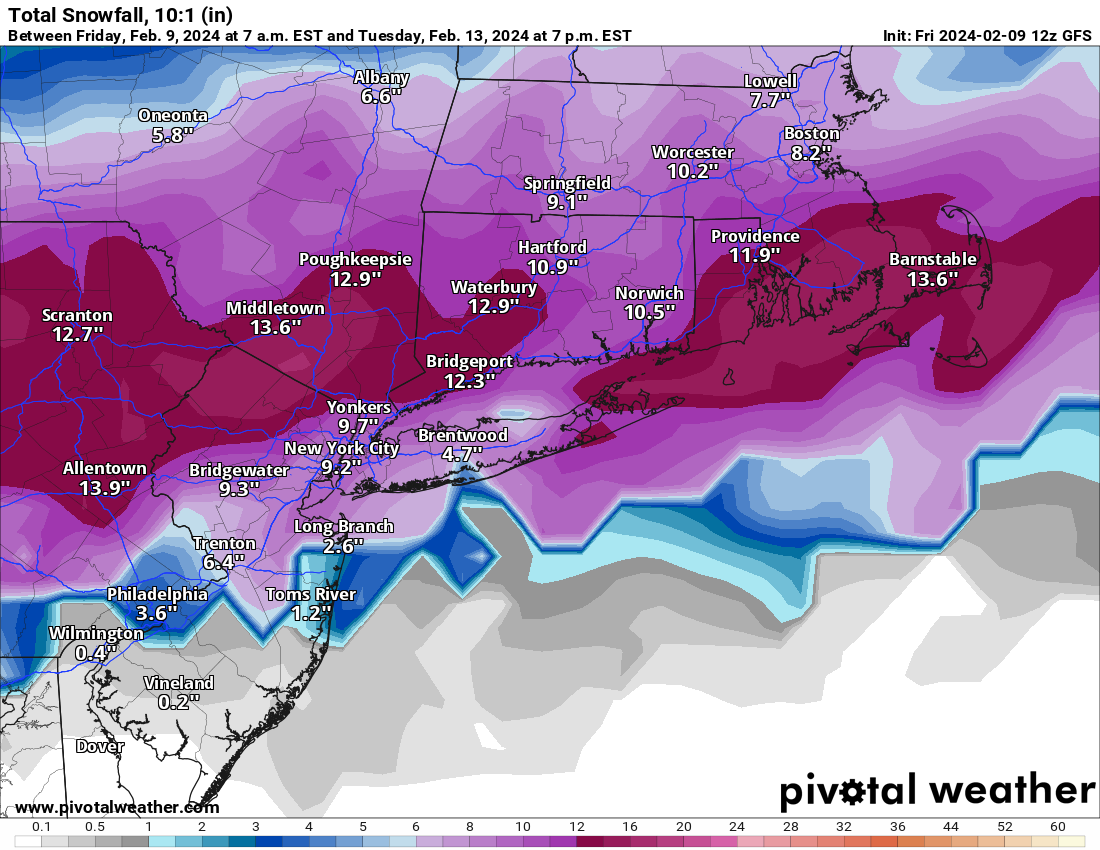
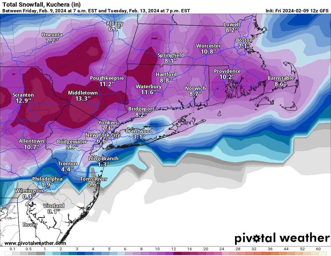
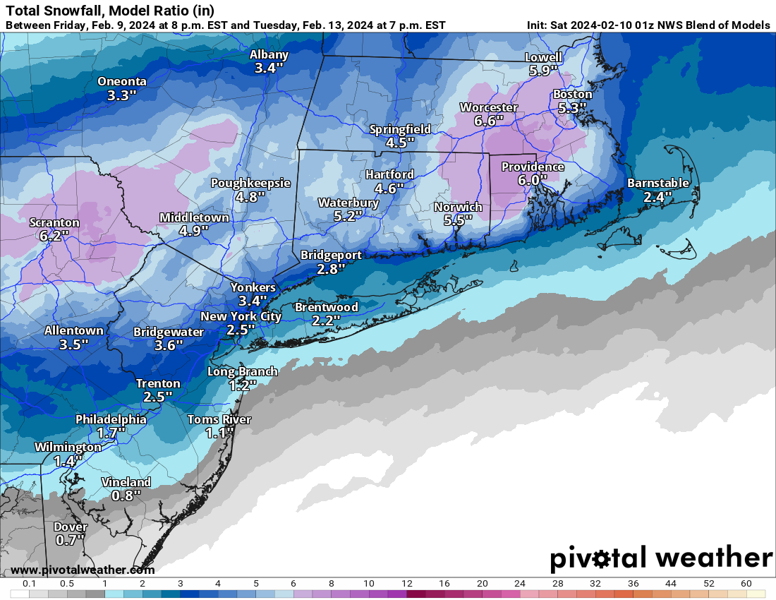
- Tonight's 0Z GFS shows a general 6-10" snowfall for our entire region (mostly falling from 7 am to 4 pm Tuesday, while the 12Z GFS showed a significant snowstorm south of 276/195 (minor/moderate north of there)
- The 0Z Euro shows 6-10" N of 78 and several inches from 195/276 to 78, falling from about 4 am to 10 am, after 1/2-3/4" of rain late Monday into Tuesday morning, while the 12Z a significant snowstorm N of 78 and minor/moderate snow south of there.
- The 0Z UK shows a few inches of snow for areas S of 78 after 1/2" or so of rain (but very little snow or precip overall N of 78), while the 12Z UK showed only an inch or two in spots N of 78 after about 1/4" of rain for most. It's just been a drier model.
- And tonight's 0Z CMC shows maybe 1/4" of rain for everyone followed by a couple of inches of snow, largely N or 78, while the 12Z CMC only had snow along/N of 90 (yes 90 in NY/MA), so it made a huge jump southward in precip towards our area.
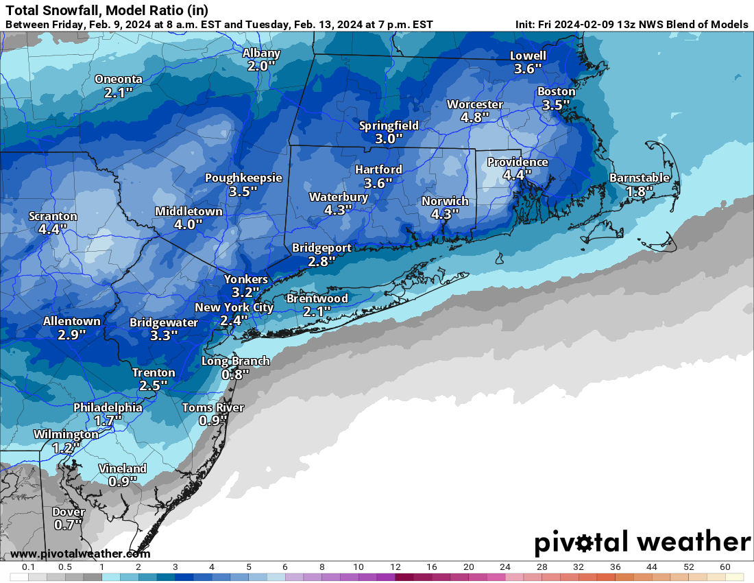
- Lastly, the NBM (model blend), which the NWS follows closely, went from about an inch or so to 2" N of 78 at 12Z to 2-4" N of 78 and 1-3" between 78 and 195/276 at 0Z tonight, a modest increase.
Still, so much can change, but the likelihood of a complete miss is pretty low. However, having confidence in a mostly/all rain vs. mostly/all snow or somewhere in between (and where the heaviest precip/snow/rain is) outcome is extremely low at this point. It's also likely that even if there is significant snow falling from the sky, it could have a hard time accumulating with temps likely at or just above 32F and some of the snow falling during the day, unless intensity is fairly high. Fortunately, with the main pieces of energy now being over land (they were over the Pacific or far north with sparse data inputs leading to higher uncertainty) and given that we're closer to the event, when the error bars shrink, hopefully we'll start seeing more consensus by tomorrow night or Saturday. For now, stay tuned.
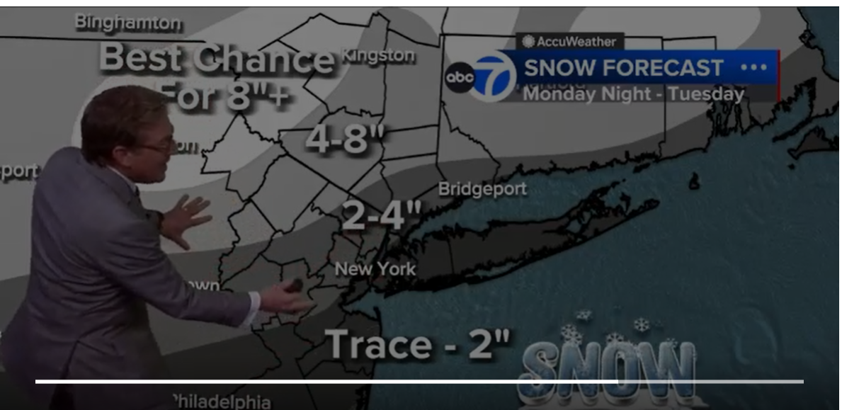
Not sure what the NWS is going to do with the current wildly varying model depictions of the storm, but they did at least move towards a possible snowier outcome with their 4 pm discussion today, after dismissing snowfall chances yesterday morning. Specifically, this morning, they were only calling for a chance of snow well NW of 95 with rain for 95/coast, but as per the part in bold, they're acknowledging that a plowable snow is possible all the way down to 95 (the fall line). Below are the usual links to the NWS and the AmericanWx thread and I also included a link to a fantastic summary of the synoptic setup by brooklynwx (a well-respected met) highlighting the things that might still go wrong, but showing that some accumulating snow for even 95/coast is possible.
https://www.weather.gov/phi/
https://www.americanwx.com/bb/topic...m-potential-rain-snow-mix-on-feb-1314/page/2/
https://www.americanwx.com/bb/topic/59981-february-2024/?do=findComment&comment=7200829
LONG TERM /SUNDAY NIGHT THROUGH THURSDAY/...
Unsettled weather on tap for the start of the new work week as
a developing storm system impacts the Northeast and Mid-
Atlantic. However, there are numerous inconsistencies among the
models that leads to a low confidence forecast.
A deep upper trough over the West Coast ejects into the
southern Plains, and the base of the trough pinches off into a
closed upper low over the Southern Plains and Gulf Coast states
Sunday night. Surface low pressure develops out ahead of it and
moves towards the Mid-Atlantic on Monday.
This is where the models go awry. The 12Z/08 ECMWF has the low
passing through southern New Jersey and Delmarva Monday night,
and then the low intensifies off the New Jersey coast as the H5
trough follows behind it Tuesday morning. This system then
departs Tuesday afternoon. In terms of sensible weather, the
predominant ptype will be rain on Monday, changing to snow over
the southern Poconos and northern New Jersey Monday night and
Tuesday as colder air filters into the region behind the
departing low. A plowable snow is possible for those areas, and
possibly even down to the Fall Line.
The surface low is faster in the 12Z/08 CMC, with rain moving
into the region earlier on Monday, and has the low over eastern
Long Island by Tuesday morning. The storm is then gone Tuesday
afternoon before the cold air filters into the region. This
results in minimal snow accumulation.
The outlier, though it has been a consistent outlier, is the
12Z/08 GFS. The storm is much slower, with the low still over
North Carolina and Virginia Tuesday morning, and then passes
through Delmarva during the day Tuesday before departing Tuesday
night. With high pressure building in from the north, cold air
advection will be underway, and temperatures drop to below
freezing across much of the region. This results in at least a
plowable snow across much of southern New Jersey and into
Delmarva.
The NBM snow probabilities have a less than 10 percent chance
for 4 inches of snow or more in 24 hours ending at 00Z Wednesday
for most areas south of the Fall Line, and up to 25 percent
chance for 4 inches of snow or more in the 24 hours ending at
00Z Wednesday for the southern Poconos and northern New Jersey.
Due to the low confidence in the forecast, opted to follow the
NBM guidance closely. This results in likely PoPs for Monday
afternoon and Monday night, and chance PoPs for Tuesday morning.
Opted to keep slight chance PoPs continuing into Tuesday
afternoon, mainly due to the GFS being slower.
Last edited: