
I do, too, but only after the event, which is why I've been arguing kind of for sport on things I wouldn't respond to during an active threat. This thread is now meaningless, so I'll have some fun with it.Well I’ll admit, I do sometimes enjoy the collateral damage from that part of it. 🤷♂️
Colleges
- American Athletic
- Atlantic Coast
- Big 12
- Big East
- Big Ten
- Colonial
- Conference USA
- Independents (FBS)
- Junior College
- Mountain West
- Northeast
- Pac-12
- Patriot League
- Pioneer League
- Southeastern
- Sun Belt
- Army
- Charlotte
- East Carolina
- Florida Atlantic
- Memphis
- Navy
- North Texas
- Rice
- South Florida
- Temple
- Tulane
- Tulsa
- UAB
- UTSA
- Boston College
- California
- Clemson
- Duke
- Florida State
- Georgia Tech
- Louisville
- Miami (FL)
- North Carolina
- North Carolina State
- Pittsburgh
- Southern Methodist
- Stanford
- Syracuse
- Virginia
- Virginia Tech
- Wake Forest
- Arizona
- Arizona State
- Baylor
- Brigham Young
- Cincinnati
- Colorado
- Houston
- Iowa State
- Kansas
- Kansas State
- Oklahoma State
- TCU
- Texas Tech
- UCF
- Utah
- West Virginia
- Illinois
- Indiana
- Iowa
- Maryland
- Michigan
- Michigan State
- Minnesota
- Nebraska
- Northwestern
- Ohio State
- Oregon
- Penn State
- Purdue
- Rutgers
- UCLA
- USC
- Washington
- Wisconsin
High Schools
- Illinois HS Sports
- Indiana HS Sports
- Iowa HS Sports
- Kansas HS Sports
- Michigan HS Sports
- Minnesota HS Sports
- Missouri HS Sports
- Nebraska HS Sports
- Oklahoma HS Sports
- Texas HS Hoops
- Texas HS Sports
- Wisconsin HS Sports
- Cincinnati HS Sports
- Delaware
- Maryland HS Sports
- New Jersey HS Hoops
- New Jersey HS Sports
- NYC HS Hoops
- Ohio HS Sports
- Pennsylvania HS Sports
- Virginia HS Sports
- West Virginia HS Sports
ADVERTISEMENT
You are using an out of date browser. It may not display this or other websites correctly.
You should upgrade or use an alternative browser.
You should upgrade or use an alternative browser.
OT: Another Minor/Moderate,Snow Event on Friday (1/19); Still Some Uncertainty
- Thread starter RU848789
- Start date
Haha. You cherry pick your totals. Maybe post them all like bac does. And why did you think I cared if NYC was going to see less snow when I already told you the actual professionals in Philadelphia predicted 3-6in? (And nailed it) Those same professionals never brought up any change to snow for yesterday and this morning. But you had to be you and wish cast the "possibility" of snow.Actually, last week I put a few posts in this thread that got a few folks riled up. First, on Weds I posted about yesterday's storm which looked like it might be whiter 4 days before it hit and Friday night I posted about a potential pattern change coming in Feb (probably starting around 2/12 which is about 3-4 days later than originally thought) to a colder and possibly snowier regime. So people weren't talking about the storm on 1/19...other than WB who has some weird fixation about when I post Philadelphia snow reports (but says nothing when bac or others post those same reports).

Now you're just full of shit. I posted the complete set of observations from Philadelphia after the storm and posted the 3 observations during the storm that the NWS published in their preliminary report - there were no other reports at that time, so no cherry picking. And the pros/NWS got Philly/SNJ/SEPA right, but missed badly for anyone N of 78 where 2-4/3-5" were predicted and I said that was overdone and unlikely to verify the day before the storm and I was right.Haha. You cherry pick your totals. Maybe post them all like bac does. And why did you think I cared if NYC was going to see less snow when I already told you the actual professionals in Philadelphia predicted 3-6in? (And nailed it) Those same professionals never brought up any change to snow for yesterday and this morning. But you had to be you and wish cast the "possibility" of snow.
Boom! He is the King Cherry Picker and the Queen of Wishcasting.Haha. You cherry pick your totals. Maybe post them all like bac does. And why did you think I cared if NYC was going to see less snow when I already told you the actual professionals in Philadelphia predicted 3-6in? (And nailed it) Those same professionals never brought up any change to snow for yesterday and this morning. But you had to be you and wish cast the "possibility" of snow.
You are full of crap. You replied to me on Friday and only listed 6 spots and again later on. Do you forget doing that? Did you forget you singled me to tell me NYC would get less snow than NYC? Why would I care?? I already posted that before your dumb post.Now you're just full of shit. I posted the complete set of observations from Philadelphia after the storm and posted the 3 observations during the storm that the NWS published in their preliminary report - there were no other reports at that time, so no cherry picking. And the pros/NWS got Philly/SNJ/SEPA right, but missed badly for anyone N of 78 where 2-4/3-5" were predicted and I said that was overdone and unlikely to verify the day before the storm and I was right.
I'm not talking about the NWS. Go back and read who I was quoting. The local Philly TV stations were all in step and nailed. Where did I bring up the NWS. Are you going to complain again that you read too many posts and were tired. You not only cherry pick those few 6 spots but can't even remember who I consistently post to everyone what the Philadelphia stations are saying as in the last few years they've been more accurate in the end then Mt. Holly NWS.
Last edited:
Wrong again. The NWS regularly updates their observations and in the late morning they had 3 locations listed, then by late in the day they had 7 locations listed all of which I posted (not 6 locations as you said). That was it. The day after the storm around noon, they posted 10 Philly locations, adding 3 more, as per below (not including the one observation at 1:27 pm which they should have left out as the snow wasn't over yet). I don't control how many observations the NWS picks from Philly - all I do is post all of the ones I see (ergo, no cherry picking) and, for the record, bac didn't post any PA observations (I normally post the NJ, PA, and SENY obs from the Philly and NYC ofifices, but didn't for this storm).You are full of crap. You replied to me on Friday and only listed 6 spots and again later on. Do you forget doing that? Did you forget you singled me to tell me NYC would get less snow than NYC? Why would I care?? I already posted that before your dumb post.
I'm not talking about the NWS. Go back and read who I was quoting. The local Philly TV stations were all in step and nailed. Where did I bring up the NWS. Are you going to complain again that you read too many posts and were tired. You not only cherry pick those few 6 spots but can't even remember who I consistently post to everyone what the Philadelphia stations are saying as in the last few years they've been more accurate in the end then Mt. Holly NWS.
And I have no idea why you keep bringing up an innocuous comment about Philly vs. NYC. All I said was, "2-3" being reported by folks in and around Philly, so far. Philly is going to be way ahead of NYC after this storm, lol." I was simply kidding around (a bit of gallows humor for the NYC folks who got shafted again on snow) and I mentioned the reports from Philly, as I hadn't yet heard any snowfall reports from you yet. Making simple conversation at that point.
https://mesonet.agron.iastate.edu/w...E1-8iVmT1oA_cVk4_iXJ76DulhXjrXJSOuYX8aQvWyQkI
...Philadelphia County...
1 WSW Belmont 5.9 in 0350 PM 01/19 Public
Philadelphia 5.0 in 0353 PM 01/19 Public
Shawmont 4.8 in 0535 PM 01/19 Public
1 NNW Northeast Philadelphia 4.7 in 0729 PM 01/19 Trained Spotter
Philadelphia International A 4.6 in 0700 PM 01/19 ASOS
1 SE Center City 4.3 in 0420 PM 01/19 Trained Spotter
Fox Chase 4.3 in 0600 PM 01/19 Public
Rockledge SE 4.3 in 0700 AM 01/20 COCORAHS
Philadelphia 4.2 in 0900 AM 01/20 COCORAHS
2 SE Point Breeze 3.5 in 0330 PM 01/19 Trained Spotter
...Philadelphia County...
1 WSW Belmont 5.9 in 0350 PM 01/19 Public
Philadelphia 5.0 in 0353 PM 01/19 Public
Shawmont 4.8 in 0535 PM 01/19 Public
1 NNW Northeast Philadelphia 4.7 in 0729 PM 01/19 Trained Spotter
Philadelphia International A 4.6 in 0700 PM 01/19 ASOS
1 SE Center City 4.3 in 0420 PM 01/19 Trained Spotter
Fox Chase 4.3 in 0600 PM 01/19 Public
You're a little late. Bac also doesn't add unnecessary commentary when posting amounts. Makes it easier to find. You can't help yourself. Nothing is simple, all your posts are like War and Peace, go on and on and on...Wrong again. The NWS regularly updates their observations and in the late morning they had 3 locations listed, then by late in the day they had 7 locations listed all of which I posted (not 6 locations as you said). That was it. The day after the storm around noon, they posted 10 Philly locations, adding 3 more, as per below (not including the one observation at 1:27 pm which they should have left out as the snow wasn't over yet). I don't control how many observations the NWS picks from Philly - all I do is post all of the ones I see (ergo, no cherry picking) and, for the record, bac didn't post any PA observations (I normally post the NJ, PA, and SENY obs from the Philly and NYC ofifices, but didn't for this storm).
And I have no idea why you keep bringing up an innocuous comment about Philly vs. NYC. All I said was, "2-3" being reported by folks in and around Philly, so far. Philly is going to be way ahead of NYC after this storm, lol." I was simply kidding around (a bit of gallows humor for the NYC folks who got shafted again on snow) and I mentioned the reports from Philly, as I hadn't yet heard any snowfall reports from you yet. Making simple conversation at that point.
https://mesonet.agron.iastate.edu/w...E1-8iVmT1oA_cVk4_iXJ76DulhXjrXJSOuYX8aQvWyQkI
...Philadelphia County...
1 WSW Belmont 5.9 in 0350 PM 01/19 Public
Philadelphia 5.0 in 0353 PM 01/19 Public
Shawmont 4.8 in 0535 PM 01/19 Public
1 NNW Northeast Philadelphia 4.7 in 0729 PM 01/19 Trained Spotter
Philadelphia International A 4.6 in 0700 PM 01/19 ASOS
1 SE Center City 4.3 in 0420 PM 01/19 Trained Spotter
Fox Chase 4.3 in 0600 PM 01/19 Public
Rockledge SE 4.3 in 0700 AM 01/20 COCORAHS
Philadelphia 4.2 in 0900 AM 01/20 COCORAHS
2 SE Point Breeze 3.5 in 0330 PM 01/19 Trained Spotter
...Philadelphia County...
1 WSW Belmont 5.9 in 0350 PM 01/19 Public
Philadelphia 5.0 in 0353 PM 01/19 Public
Shawmont 4.8 in 0535 PM 01/19 Public
1 NNW Northeast Philadelphia 4.7 in 0729 PM 01/19 Trained Spotter
Philadelphia International A 4.6 in 0700 PM 01/19 ASOS
1 SE Center City 4.3 in 0420 PM 01/19 Trained Spotter
Fox Chase 4.3 in 0600 PM 01/19 Public
Sometimes less is more. One of the reasons I love the local Philly TV stations. (Bonus as they finally stopped the hype to worse case scenarios unlike you and Mt. Holly, which has lead to much more accurate forecasts) They keep it simple and graphics are soooo much better!
Anyway looking like a good week. Any disc golf scheduled especially Thursday where it's going to feel almost spring like? I'll be cycling somewhere. Rode up to and around Valley Forge National Park last Saturday. Sure beats shoveling snow.
Any chance the bickering participants in this thread could just stop the petty nonsense?
Moving forward, maybe the #s camp and the Bac camp should each have its own storm thread and then just stay the hell out of each other's thread and assessment. As is, this back-and-forth attacking/bickering is just plain foolish.
Moving forward, maybe the #s camp and the Bac camp should each have its own storm thread and then just stay the hell out of each other's thread and assessment. As is, this back-and-forth attacking/bickering is just plain foolish.
Nah.Any chance the bickering participants in this thread could just stop the petty nonsense?
Moving forward, maybe the #s camp and the Bac camp should each have its own storm thread and then just stay the hell out of each other's thread and assessment. As is, this back-and-forth attacking/bickering is just plain foolish.
One’s enough IMO.
But I am beginning to think I might be being played here.🤔🤨🧐
Weather threads should be on the CE board.Oh my God, The Nancy and Jane's are in full meltdown, over weather no less. It can't possibly be more toxic in the CE threads, no way, lmfao.
The endurance (from both sides) is truly astonishing 🙄
Never forget, it takes Two To Tango. If one side just stopped being provoked, the other side would get bored.
Any chance the bickering participants in this thread could just stop the petty nonsense?
I doubt it: they really seem to enjoy the interaction.
Weather threads should be on the CE board.
Perhaps Richie could create a non-premium Weather Board.
Nothing is more current of an event than weather.Never forget, it takes Two To Tango. If one side just stopped being provoked, the other side would get bored.
I doubt it: they really seem to enjoy the interaction.
Perhaps Richie could create a non-premium Weather Board.
Weather is something that interests everyone, not just premium members.Nothing is more current of an event than weather.
It wouldn't be an issue if people didn't use it to attack others.
Never forget, it takes Two To Tango. If one side just stopped being provoked, the other side would get bored.
agree - that's why I specified "from both sides" . bac is never gonna stop. but perhaps if #s could manage to ignore him then maybe bac may stop (or at least curb) the trolling.
suggestion for @RU848789: if someone is trolling you (and there is a very small handful in addition to bac) - put them on ignore. It's a great feature - really! you wont even see their stupid comments - and then you wont feel compelled to respond to them.
I think I am a bit like you - I find it really hard not to respond when someone says something really stupid and/or is just being an a-hole. so realize that about yourself - and just put them on ignore. ignorance truly is bliss.
unless you deep down really get off on the back-and-forth, in which case you kinda deserve the trolling ;)
The fact is the last 2 or 3 pages really isnt about weather
Its a thread should have closed shop long ago
Its a thread should have closed shop long ago
It’s why I think l’m being played here.The fact is the last 2 or 3 pages really isnt about weather
Its a thread should have closed shop long ago
Its now a banter thread with insults so rather odd to see debate about poor Numbers thread being overtaken by Bac minions. By the why I haven't posted all that much in this thread since the weather stopped happening
Its a painful to ready through the last 3 pages
Its a painful to ready through the last 3 pages
It's going on to satiate the thirst for attention.Its now a banter thread with insults so rather odd to see debate about poor Numbers thread being overtaken by Bac minions. By the why I haven't posted all that much in this thread since the weather stopped happening
Its a painful to ready through the last 3 pages
shocked our resident chemist did not post the possibility of snow showers across portions of our area tonight into the morning as a very weak clipper system heads our way
Clipper system looks likely to degenerate at the surface as it
heads southeastward and redevelop along the Carolina coast as
the upper level trough closes off for a time as it heads towards
the southeastern coast. The bulk of the forcing and moisture
associated with that system will stay well to our southwest.
However, the moisture moving west off the ocean looks like it
will be just enough when coupled with some isentropic lift aloft
and vorticity advection on the north side of the system to bring
some of those scattered showers over the ocean inland. QPF looks
minimal to negligible for most of the region, and temperatures
will be moderating as the easterly flow brings a relatively
warmer air mass inland, so while it may start as flurries/snow
showers nearly everywhere, think a transition to sprinkles/rain
showers will occur as we head through tonight and Wednesday
morning starting near the coast and heading inland. Highest
coverage of precipitation looks to be late tonight based on best
isentropic lift and upper-level PVA, which is still a bit tricky
in the Delaware Valley, but should be mostly rain southeast of
I-95 while snow across the LV and Poconos into NW NJ. Have
confined any snow accumulations to these latter areas but still
expect no more than an inch accumulation, mainly in the high
Poconos. Near and southeast of I-95 not expecting any impacts,
but in the Lehigh Valley and NW NJ, minor accumulations are
possible on paved surfaces overnight tonight which could result
in slippery roads, with better odds of this occurring in the
higher terrain of the Poconos. Temperatures will be fairly
steady through tonight.
System starts pulling away with weakening forcing on Wednesday,
so temps should moderate a bit more as precip mostly dwindles.
Maintain some sprinkles/flurries thru the day however given some
CAMS like the 12Z HRRR are indicative of such. Highs should turn
out milder with the oceanic flow continuing, nudging into the
lower 40s along and east of I-95, but 30s further NW.
light at the end of the tunnel. Not only are the days noticably longer but average temps on their way up
2 years ago yesterday..was this the last time we had a REAL event
Yeah, that stunk.2 years ago yesterday..was this the last time we had a REAL event
Clipper going to drop 1-3" in the Boone NC area overnight, more at elevations above 3500'. Temps should moderate some after this, until a potential mega-system threatens Feb 5-6, with 12"+ of snow a looming possibility. Spring can't come soon enough....
I don't remember that one. Sharp cut off - 4.1 inches to 8 inches +2 years ago yesterday..was this the last time we had a REAL event
But the first insult/troll/whatever ALWAYS comes from one of the folks who dislikes my posts or the weather threads in general, never from me, but these days I usually ignore the trolling attempts until after the event is over and in this case, you guys did some housekeeping on troll posts on the first page, which was appreciated, and after that, the thread ran remarkably well through the event with little major bickering. Even after that there was only some arguing about snowfall amounts, snow removal/salting, and a few other things, which I have no major issue with as these weren't generally "attacks" just arguments.Never forget, it takes Two To Tango. If one side just stopped being provoked, the other side would get bored.
I doubt it: they really seem to enjoy the interaction.
Perhaps Richie could create a non-premium Weather Board.
The thread didn't start going downhill until I posted the heads up posts on this past weekend's eventual minor snowfall on Wednesday and the pattern change heads up on Friday, both of which elicited some of the usual bickering/trolling and as I've said a couple of times in this thread, I don't care about weather threads much after events are over, meaning I have no issue mixing it up with people who argue with me. I let the insults/criticism go, generally before/during an event but not after. So there's arguing now, which I'm surprised people seem annoyed by as that happens to many threads.
And nobody wants a non-premium weather board that I know of - people come to the football board for all kinds of OT discussions, including on the weather and I doubt they want to change that.
Hopefully the new pattern change thread (colder and possibly snowy pattern coming) I intend to post when I have some time later today/tonight will remain civil. I'll be ignoring insults/trolling in that one, but a little moderation might be nice if it comes to that.
If people think this thread is bad, they haven't been in the windfarm thread which has gone completely off the rails, filled with invective, political insults, pandemic arguments, etc. and yet it's still going.
Why don't you start a thread? Even if we start posting threads for fairly minor threats as some of us were discussing, this would even be below that threat level, with no model showing more than 1" anywhere and the NWS only mentioning an inch for the Poconos, with almost everywhere limited to 1/2" or less and essentially zero snow accumulation expected S of 78, as per the NBM model blend. The only reason I almost started the thread for this past weekend's event was that 3-4 days out there was potential for at least a few inches down to 95 - this clipper has never had that kind of potential and even if folks see a little snow it'll likely only be on the grass Mood flakes and a dusting would be nice, though.shocked our resident chemist did not post the possibility of snow showers across portions of our area tonight into the morning as a very weak clipper system heads our way
Clipper system looks likely to degenerate at the surface as it
heads southeastward and redevelop along the Carolina coast as
the upper level trough closes off for a time as it heads towards
the southeastern coast. The bulk of the forcing and moisture
associated with that system will stay well to our southwest.
However, the moisture moving west off the ocean looks like it
will be just enough when coupled with some isentropic lift aloft
and vorticity advection on the north side of the system to bring
some of those scattered showers over the ocean inland. QPF looks
minimal to negligible for most of the region, and temperatures
will be moderating as the easterly flow brings a relatively
warmer air mass inland, so while it may start as flurries/snow
showers nearly everywhere, think a transition to sprinkles/rain
showers will occur as we head through tonight and Wednesday
morning starting near the coast and heading inland. Highest
coverage of precipitation looks to be late tonight based on best
isentropic lift and upper-level PVA, which is still a bit tricky
in the Delaware Valley, but should be mostly rain southeast of
I-95 while snow across the LV and Poconos into NW NJ. Have
confined any snow accumulations to these latter areas but still
expect no more than an inch accumulation, mainly in the high
Poconos. Near and southeast of I-95 not expecting any impacts,
but in the Lehigh Valley and NW NJ, minor accumulations are
possible on paved surfaces overnight tonight which could result
in slippery roads, with better odds of this occurring in the
higher terrain of the Poconos. Temperatures will be fairly
steady through tonight.
System starts pulling away with weakening forcing on Wednesday,
so temps should moderate a bit more as precip mostly dwindles.
Maintain some sprinkles/flurries thru the day however given some
CAMS like the 12Z HRRR are indicative of such. Highs should turn
out milder with the oceanic flow continuing, nudging into the
lower 40s along and east of I-95, but 30s further NW.
light at the end of the tunnel. Not only are the days noticably longer but average temps on their way up
The tunnel?
Lol.
The coastal area's got hammered. We in So Monmouth and Ocean I got about 1.5 ft.I don't remember that one. Sharp cut off - 4.1 inches to 8 inches +
I don't remember that one. Sharp cut off - 4.1 inches to 8 inches +
Thats probably why
Why don't you start a thread? Even if we start posting threads for fairly minor threats as some of us were discussing, this would even be below that threat level, with no model showing more than 1" anywhere and the NWS only mentioning an inch for the Poconos, with almost everywhere limited to 1/2" or less and essentially zero snow accumulation expected S of 78, as per the NBM model blend. The only reason I almost started the thread for this past weekend's event was that 3-4 days out there was potential for at least a few inches down to 95 - this clipper has never had that kind of potential and even if folks see a little snow it'll likely only be on the grass Mood flakes and a dusting would be nice, though.
Why would i start a thread on a nothing event that only deserves a mention which I did
We must have a psychiatrist here in our TKR community who can shine some light on what makes people do what they do on these threads. Would be fascinating to hear? Anyone?
You were the hardest hit. The further West the less total in general.The coastal area's got hammered. We in So Monmouth and Ocean I got about 1.5 ft.
Not really liking the post, but thanks for the info/perspective.The coastal area's got hammered. We in So Monmouth and Ocean I got about 1.5 ft.
Got it.Not really liking the post, but thanks for the info/perspective.
We're even. Me and my back weren't liking the snow😠
As I get a bit older, I never root for snow. I’m fine with the cosmetic variety, but the 18-24 dumps I can do without.Got it.
We're even. Me and my back weren't liking the snow😠
Have always loved them, will always love them and there would be worse ways to kick it than a a heart attack while shoveling out from a blizzard in 2057 at age 95. Just hoping it's not in 2027, lol.As I get a bit older, I never root for snow. I’m fine with the cosmetic variety, but the 18-24 dumps I can do without.
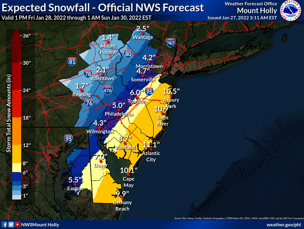
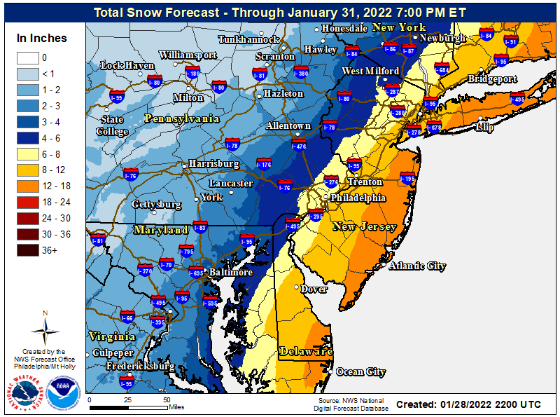
Yes, that was a good storm and very well forecast by the NWS, even from 2+ days out (first map) and the night before forecast was excellent (2nd map). Predicted 8.25" for my house and got 8.5". Was good for 95, but just missed being epic, like it was for the coast and LI. Was even a fairly civil thread even if it was started ~5 days out. Sometimes the medium range models do well.2 years ago yesterday..was this the last time we had a REAL event
So we have been in an awful stretch of cloudy drab weather day after day after day. I do not recall the last extended period of sunshine. Thats going to change after 3 more cloudish days which at least will have some sun at times but starting Saturday looking like a glorious stretch ofdry blue skies and sunny conditions for at least 5 days temps in the low to mid 40s perhaps rising to 50 or above 7-10 days from now
Similar threads
- Replies
- 135
- Views
- 6K
- Replies
- 472
- Views
- 19K
ADVERTISEMENT
ADVERTISEMENT