ADVERTISEMENT

OT: Another Minor/Moderate,Snow Event on Friday (1/19); Still Some Uncertainty

RU848789

Legend
Gold Member
Jul 27, 2001
60,561
39,141
113
Metuchen, NJ
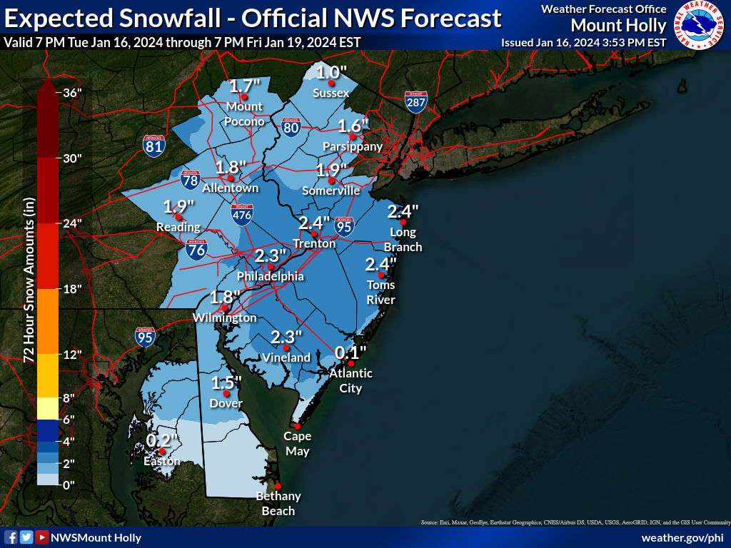
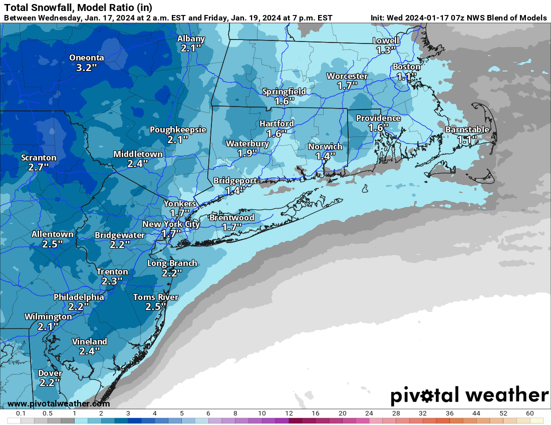
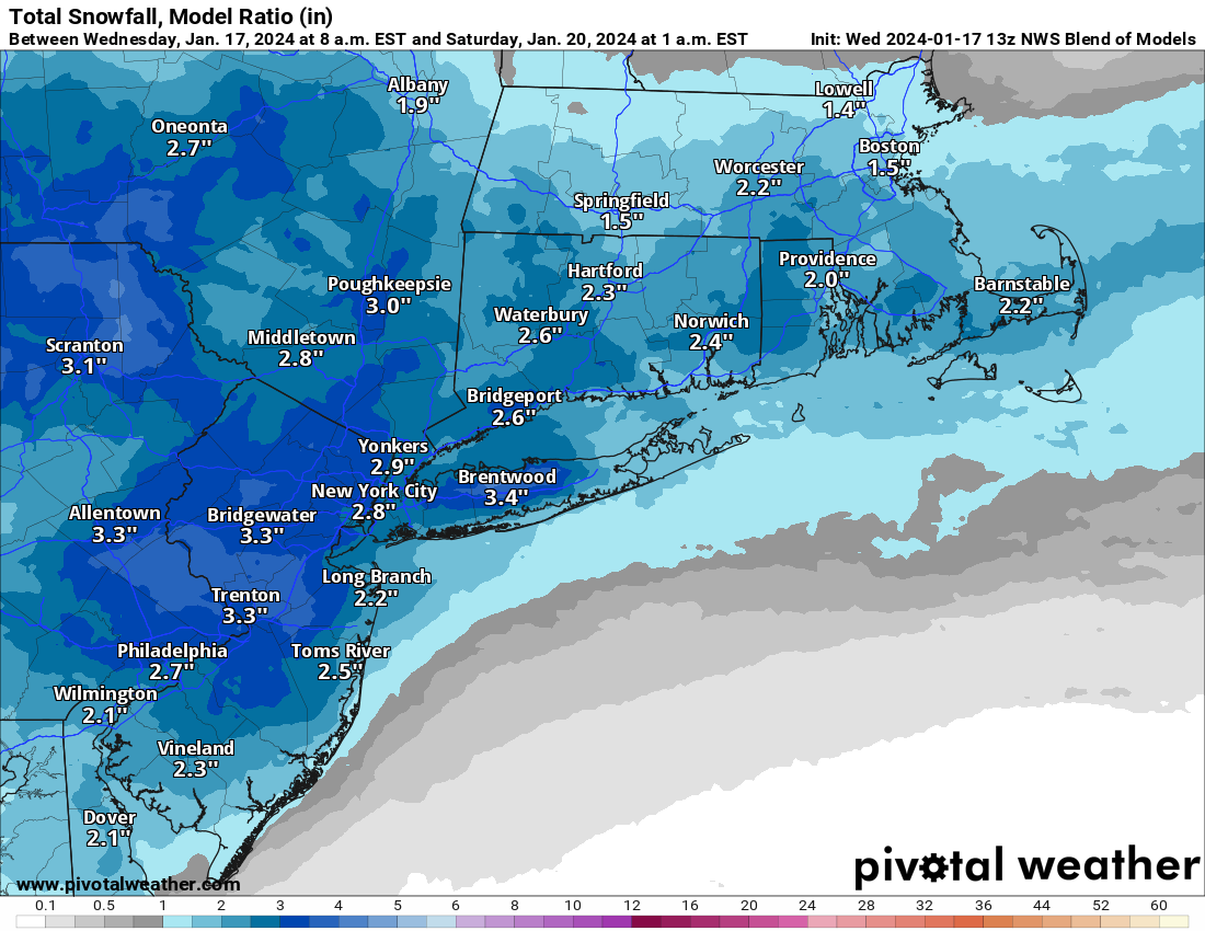
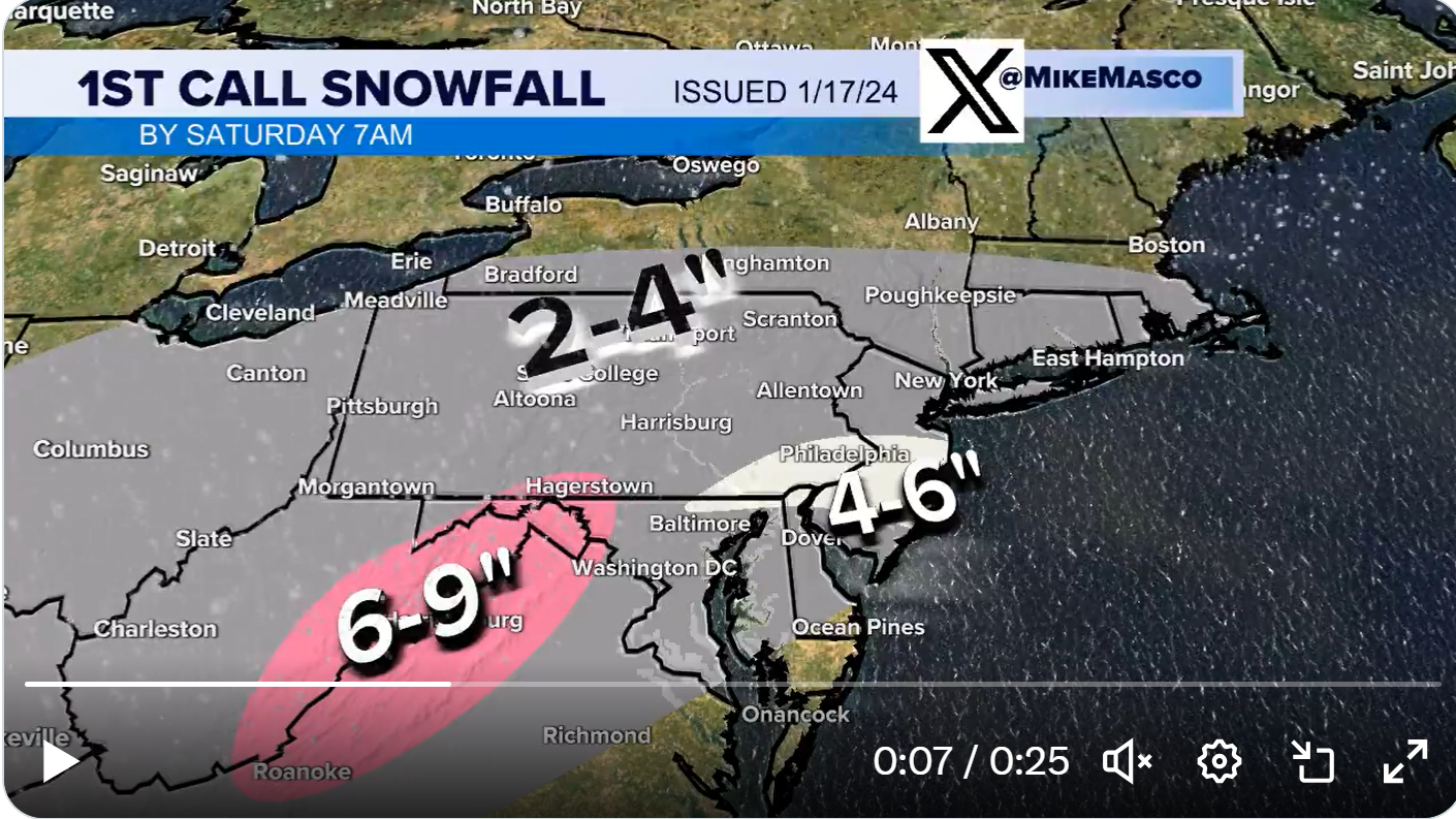
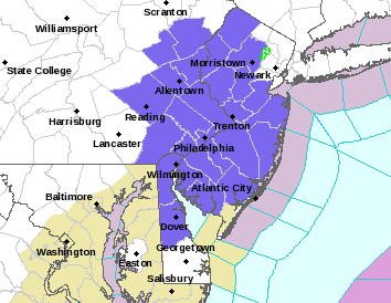
A few days ago there were runs showing a monster snowstorm in this timeframe, but since then the models have backed off of any idea of a phasing system (when northern and southern jet stream systems combine) blowing up into a huge storm. Models now are looking at probably a minor (1-2") to moderate (2-5") event. It's looking now like there will only be a southern stream system that comes up the coast, but it is likely to be fairly far offshore, which normally would only bring light snow to the area (especially at the coast), but there are signals of an inverted trough feature forming and these can focus precip (snow here given quite cold temps in place) well NW of the low. However, they’re notoriously difficult to forecast, as they often have a narrow area of heavy precip surrounded by areas of much lighter precip; see the NWS discussion below for the gory details.

This uncertainty is why the models have been bouncing around a lot, especially almost 4 days before the Friday start to the event. To summarize, for Friday into early Saturday, today's 12Z CMC shows a 2-5" event, the UK shows a 1-3" event (but only south of 78) and the Euro shows roughly a 2-4" event, but the 18Z GFS shows a 3-6" event, after showing a 1-2" event at 12Z (hence the uncertainty). So, the 4 major global models are all showing a light to moderate event (not too different from what we're expecting tomorrow, although the snow is being generated in a completely different setup). But a complete miss (or just some light snow at the coast) is definitely possible and a more significant event is also possible, plus the main energy for this storm is still out in the Pacific, so our initial conditions for it are not robust (just like this current storm; we didn't start getting a handle on it until ~48 hours before the event). So we track. Link to the thread on AmericanWx is below.

https://www.americanwx.com/bb/topic...a-5-swath-in-part-of-the-nyc-subforum/page/2/

Edit changed thread title from, "OT: Another Snow Event on Friday (1/19)? Probably Minor/Moderate, but High Uncertainty" to current title on 1/18 at 8:45 am.

Area Forecast Discussion
National Weather Service Mount Holly NJ
323 PM EST Mon Jan 15 2024

The period Thursday night through Friday night still looks to
be the most challenging portion of the forecast as a series of
impulses continue to rotate around the base of the longwave
trough. In short, a coastal storm system is forecast to develop
to our south and east while tracking offshore into the Western
Atlantic during this timeframe. While this still has the
potential to bring the area another round of wintry precip,
there is a lot of uncertainty in the forecast at this time.
Forecast guidance as of today continues to be persistent with
the track of the main surface low, tracking off the coast to our
south and east. With cold air in place from the antecedent
arctic high, there should be an abundance of cold air in place
for the p-type to be mostly snow. In addition, guidance is also
hinting at an inverted trough (Norlun Trough) set-up on the
backside of the low, which may enhance any precipitation that
falls within the vicinity of this feature as the vortmax passes
by. As there is vast amount of uncertainty with this period,
have decided to remain close to the NBM for this forecast
package. Too early for snow amounts, but NBM probabilities at
this time, show that at least a 40-60% chance of 1 inch of snow
of more can be expected for most of the area, with the exception
of the Delmarva and extreme southern New Jersey where some
mixing may occur.
 
Last edited:
96679e31-8c06-4b58-9bcb-c4d399790185_text.gif


(but glad you followed the rules 😉)
 
Its likely a smaller event than this one
Probably, but it likely has a higher ceiling, too. The 0Z GFS and Euro were both a weak mess with ~1" (or less) for most, while the CMC had 2-4" south of 78 and 1-2" N of 78, but the UK has a general 4-8" for most. That would certainly argue, overall, for a smallish event, but we're still 3.5 days out with a very volatile setup, so I'd give it another 36 hours or so before giving up on anything more than a minor snowfall.
 
So, the NWS has already put out a preliminary snowfall map, showing a general 2-3" event south of 78 and east of the Delaware River and a 1-2" event N of 78/W of the Delaware, with snow likely from the pre-dawn hours on Friday into early Saturday (note that the map below only goes through 7 pm Friday and a bit more snow could fall after that). No map yet from NWS-NYC, but 1-2" would be a good bet.

Edit: NWS-NYC map now available: 1-2" for most, but 2-3" for LI, closer to the precip source...

While this storm is totally different in setup from today's storm(s), the outcome will have some similarities with today's event in that it will likely be a long duration event with light intensity snow mostly, but with temps in the 20s mostly (highs around 30F), accumulations will be easy, except maybe between 10 am and 3 pm as the mid-January indirect sun will be capable of melting some of a low intensity snowfall, especially on paved surfaces.

Very little chance for mix/rain with this event, however, with the coastal low well offshore. As mentioned in the first post, the expected inverted trough which will extend from the coastal low back to our area, focusing snowfall in our area, but these setups are extremely finicky and it's quite possible we actually see a narrow band (20-30 miles wide?) of heavier snow with 3-6", surrounded by 1-3" areas of mostly light snow and predicting where that might happen is very difficult. If anyone recalls the Eagles game that got plastered with 8-9" of snow several years ago with the surrounding area getting only an inch or two, that was a very similar "Norlun trough" setup.

https://www.mattnoyes.net/new_engla...-you-forecast-weather-associated-with-it.html

ui17FGi.png


lNFWoQO.png
 
Last edited:
Tonight's models coming in with decent consistency on a minor (1-2") to moderate (2-5") snow event on Friday, with the highest amounts in some of the models being centered south of 78 down through Delaware, especially towards the coast. Doesn't mean that's a given, but it's trending that way. The chances of a miss are going down, but aren't zero.
 
Last edited:
So, the NWS has already put out a preliminary snowfall map, showing a general 2-3" event south of 78 and east of the Delaware River and a 1-2" event N of 78/W of the Delaware, with snow likely from the pre-dawn hours on Friday into early Saturday (note that the map below only goes through 7 pm Friday and a bit more snow could fall after that). No map yet from NWS-NYC, but 1-2" would be a good bet.

Edit: NWS-NYC map now available: 1-2" for most, but 2-3" for LI, closer to the precip source...

While this storm is totally different in setup from today's storm(s), the outcome will have some similarities with today's event in that it will likely be a long duration event with light intensity snow mostly, but with temps in the 20s mostly (highs around 30F), accumulations will be easy, except maybe between 10 am and 3 pm as the mid-January indirect sun will be capable of melting some of a low intensity snowfall, especially on paved surfaces.

Very little chance for mix/rain with this event, however, with the coastal low well offshore. As mentioned in the first post, the expected inverted trough which will extend from the coastal low back to our area, focusing snowfall in our area, but these setups are extremely finicky and it's quite possible we actually see a narrow band (20-30 miles wide?) of heavier snow with 3-6", surrounded by 1-3" areas of mostly light snow and predicting where that might happen is very difficult. If anyone recalls the Eagles game that got plastered with 8-9" of snow several years ago with the surrounding area getting only an inch or two, that was a very similar "Norlun trough" setup.

https://www.mattnoyes.net/new_engla...-you-forecast-weather-associated-with-it.html

ui17FGi.png


lNFWoQO.png

Responding to the general increase, overall in the 0Z and 6Z models (but not in all models), in snowfall for this system, the NWS-Philly bumped snowfall forecasts up by about 1/2-1" across the area, so they now have most of CNJ/NNJ/EPA in the 2-3" range, while having most of SNJ in the 3-4" range, with the notable exception of having <1" for the immediate NJ coast south of Toms River and SE DE, due to expected mixing or complete changeover to rain - this is the area where the biggest bust is possible in either direction.

The NWS-NYC didn't really up their forecasts, predicting 1-2" for most, except 2-3" for southern NYC and LI. There is an obvious discontinuity between the offices from Union up through Passaic, where the NWS-NYC has 1-2" while the NWS-Philly has adjacent Middlesex, Somerset, and Morris at 2-3". They should address this in future updates. It's also worth noting that the NWS-Philly is a bit more bullish than the NBM (model blend, below), while the NWS-NYC is in line with the NBM.

Expect snow to start lightly before sunrise and continue lightly to occasionally moderately until Friday evening with temps well below 32F everywhere through mid morning and rising into the upper 20s (N of 78/EPA) to around 30-31F (CNJ/most of SNJ), except into the mid-30s along the SENJ coast. Where temps remain at or below 32F, accumulation should be easy on all but untreated surfaces, although there will likely be a little melting at midday with the indirect sunlight.

There is still significant uncertainty in the snowfall forecast as per the NWS discussion below, since it's difficult to predict the level of interaction/phasing between the two primary shortwaves, such that it's still very possible the whole area just sees an inch or so (seen in a couple of models) or that most of the area (especially S of 78) sees several inches, especially where the best banding from the inverted trough feature sets up and we might not know that until Friday morning.

https://forecast.weather.gov/produc...&format=CI&version=1&glossary=1&highlight=off

https://www.americanwx.com/bb/topic...in-part-of-the-nyc-subforum-event-obs/page/7/

Area Forecast Discussion
National Weather Service Mount Holly NJ
428 AM EST Wed Jan 17 2024

Most guidance suggest that shortwave will initiate a coastal low
off the Carolinas late Thursday, that heads east-northeast off
Cape Hatteras by Friday morning. Meanwhile, a much stronger
shortwave will be tracking quickly east-southeastward from the
northern Plains early Thursday, to the Mid-Atlantic on Friday.
As it does so, some degree of phasing with the cold upper-trough
dropping southward across the Great Lakes occurs. Just how much
phasing and resulting amplification occurs is key for
determining how much snow we might see on Friday. If the initial
shortwave and surface low dominates and keeps the stronger
thermal gradient and baroclinic zone shifting offshore to our
southeast, while the better upper-level dynamics are `playing
catch-up`, we may only see several hours of light snow with
perhaps an inch or so. If the stronger shortwave can amplify and
back the flow near the coast to allow a surface low to hold
closer to the coast, and increase frontogenetic forcing for a
time on Friday, then several inches of snowfall will be
possible. Southern portions of the Delmarva to the NJ shore may
have some questionable temperatures at least Friday morning that
may keep the precipitation as rain or wet snow, but just inland
should be all snow otherwise. Given the thermal profiles and
forecast soundings, the better forcing may be lined up with the
dendritic growth zone, which would support some higher snow
ratios in the 12-15:1 range, at least away from the immediate
coast. We`ll see how the guidance shifts over the next 24 hours,
but we may need to consider issuing advisories for Friday
within the next few forecast shifts.


EU9kUnK.png


FIHVZa8.png


Vr6hWd8.png
 
Last edited:
again its looking like another 1-4 inch event throughout the area and models favor south of 95 more so than northern NJ as usual the case

with the inverted trough that cannot be counted on or predicted well as to where its sets up that could enhance amounts and thats why I said 4 even things might be closer to 2 or so in most places. Also i have seen in the post these sort of more south hits underperfrom north of 78 so keep an eye on that.

should not be a big deal if it stays all snow which it should. A storm that wouldnt close schools in the 70s and 80s but will on Friday.
 
What is time frame of storm for Friday ? Starting when and ending when approx?
 
What is time frame of storm for Friday ? Starting when and ending when approx?
looking like a 5-8AM timeframe for possible start in NJ, that could be tweaked a bit but then light snow would continue through the day and into the evening. Most of NJ would probably end by 7-8pm or possibly sooner but toward the coast monmouth/ocean/atlantic counties the precip could linger the most.

its probably a 12 hour type main show and some of the models are not really enthused for that much but higher ratios could be in play for this system....1-4 inches probably covers it
 
  • Like
Reactions: BigEastPhil
looking like a 5-8AM timeframe for possible start in NJ, that could be tweaked a bit but then light snow would continue through the day and into the evening. Most of NJ would probably end by 7-8pm or possibly sooner but toward the coast monmouth/ocean/atlantic counties the precip could linger the most.

its probably a 12 hour type main show and some of the models are not really enthused for that much but higher ratios could be in play for this system....1-4 inches probably covers it
I wish all weather threads were this civil. Adding to the discussion instead of bickering.
 
curious daughter has HS swim meet Friday 4pm at Montgomery. odds it gets postponed?
 
Hot off the presses, the NWS-Philly upped snowfall forecasts again. As I said elsewhere, I'm astounded by this, as the 12Z (and previous runs) Euro, UK, and GFS generally have 1-2" for this storm (even using Kuchera), while only the NAM, CMC and SREFs have more than 3" anywhere. I know they know way more about meteorology than anyone here, but this is unusual. At least the NBM (model blend) is much greater than the GFS/UK/Euro and not far below the NBM, but I don't recall seeing 3 of the 4 major globals discounted at this range.

Edit - well, maybe not so aggressive, lol. Mike Masco just came out with his first call and it's pretty bullish, especially from about 10 miles N of 195/276 and southward almost to Delaware Bay, where he has a 4-6" swath from the inverted trough, mainly, as per the graphic, below.

Edit #2: NWS-NYC also just upped their snowfall forecasts by about an inch across the board vs. this morning, with 2-3" for NYC and most of SENY (below the Tappan Zee) and 3-4" for extreme southern NYC and southern LI.


BJkricV.png


iW1Xriq.png


O2RBsYH.png


48hMLsx.png


Last edited:
  • Like
Reactions: RutgersK1d
And the NWS just issued advisories for 2-4" for almost every county in its office (all of the ones in blue), except Cape May and coastal DE (remember NWS-NYC has Union through Bergen)

SWVjdhn.png

.

URGENT - WINTER WEATHER MESSAGE
National Weather Service Mount Holly NJ
316 PM EST Wed Jan 17 2024

..WINTER WEATHER ADVISORY IN EFFECT FROM MIDNIGHT THURSDAY NIGHT
TO 7 PM EST FRIDAY...

* WHAT...Snow expected. Total snow accumulations of 2 to 4
inches.

* WHERE...Portions of central, northern and northwest New Jersey
and east central, northeast and southeast Pennsylvania.

* WHEN...From midnight Thursday night to 7 PM EST Friday.

* IMPACTS...Plan on slippery road conditions. The hazardous
conditions could impact the morning or evening commute.

* ADDITIONAL DETAILS...Temperatures will rapidly drop into the
teens late Friday night. Any untreated roads will become icy and
dangerous.
 
No its because the snow bias isnt possible with this minor system..but i see its starting to creep in
Show your work. What bias is there in reporting what the NWS is doing, especially when I've commented that I'm surprised by them essentially ignoring the less snowy models?

Also, I like to think that you and I and others can debate what's going to happen with the storm without it spiraling out of control, whereas when the trolling hits hard is when the threads spiral and the mods cleaned that up early on (or maybe you didn't see that).
He won’t show his work because it will show that YOU are correct, not him
 
Numbers, do you ever see the forecasts that Jonathan Carr does from weather NJ? He’s pretty good. Prior to you guys, I’d always follow him.
 
  • Like
Reactions: IL Lusciato
Hey @RUJohnny - any thoughts on what we're going to get from this system with the inverted trough feature? Are you still publishing forecasts anywhere?
Anyone's guess. You know the drill with IVTs. 2-3 statewide, stripe of 4-5 somewhere, probably a touch N and E of where currently depicted. At the moment, on hiatus. 2 kids, 2 businesses, 2 busy!
 
  • Like
Reactions: RU848789
ADVERTISEMENT
ADVERTISEMENT