I usually do, but this one just seemed so odd that I figured I'd try to get him to see the light, but to no avail.Once you realize that Bobby never relents, he thinks he's always right and everyone else wrong, it's a lot smarter to skip past his posts. He put me on ignore. Lucky me.
Colleges
- American Athletic
- Atlantic Coast
- Big 12
- Big East
- Big Ten
- Colonial
- Conference USA
- Independents (FBS)
- Junior College
- Mountain West
- Northeast
- Pac-12
- Patriot League
- Pioneer League
- Southeastern
- Sun Belt
- Army
- Charlotte
- East Carolina
- Florida Atlantic
- Memphis
- Navy
- North Texas
- Rice
- South Florida
- Temple
- Tulane
- Tulsa
- UAB
- UTSA
- Boston College
- California
- Clemson
- Duke
- Florida State
- Georgia Tech
- Louisville
- Miami (FL)
- North Carolina
- North Carolina State
- Pittsburgh
- Southern Methodist
- Stanford
- Syracuse
- Virginia
- Virginia Tech
- Wake Forest
- Arizona
- Arizona State
- Baylor
- Brigham Young
- Cincinnati
- Colorado
- Houston
- Iowa State
- Kansas
- Kansas State
- Oklahoma State
- TCU
- Texas Tech
- UCF
- Utah
- West Virginia
- Illinois
- Indiana
- Iowa
- Maryland
- Michigan
- Michigan State
- Minnesota
- Nebraska
- Northwestern
- Ohio State
- Oregon
- Penn State
- Purdue
- Rutgers
- UCLA
- USC
- Washington
- Wisconsin
High Schools
- Illinois HS Sports
- Indiana HS Sports
- Iowa HS Sports
- Kansas HS Sports
- Michigan HS Sports
- Minnesota HS Sports
- Missouri HS Sports
- Nebraska HS Sports
- Oklahoma HS Sports
- Texas HS Hoops
- Texas HS Sports
- Wisconsin HS Sports
- Cincinnati HS Sports
- Delaware
- Maryland HS Sports
- New Jersey HS Hoops
- New Jersey HS Sports
- NYC HS Hoops
- Ohio HS Sports
- Pennsylvania HS Sports
- Virginia HS Sports
- West Virginia HS Sports
ADVERTISEMENT
You are using an out of date browser. It may not display this or other websites correctly.
You should upgrade or use an alternative browser.
You should upgrade or use an alternative browser.
OT: Round 2 Rainstorm 1/12 (not as bad as round 1); Rainstorm 1/9-10 - Major Urban/Stream Flooding, High Winds and Coastal Flooding Likely
- Thread starter RU848789
- Start date
- Status
- Not open for further replies.
see above: 1-2" generally...How much rain is Fri bringing in? Not sure my water table/sump can handle another 3 inches
For the Manasquan/Wall area, NWS says 3/4 to 1 inch.
Not far from there. Hopefully that holds
Euro/CMC look snowy, GFS not so much but that's not unusual 5-6 days out. The last storm, though, on Saturday, was always going to have a sharp cutoff to the snow due to warm air, but this system looks like it'll have plenty of cold air for most - just need to get the track close enough to bring precip, which would very likely be snow. This one also doesn't look to be as juicy as Saturday's, which brought 1-1.5" of liquid (12-16" of snow where it was all snow), while the snowiest model runs, so far look to be capped at 8-10"). I'd just be happy to get an all snow event of more than 2-3".Tuesday still tending snow?
My rain gauge for the past storm, which is one of those test tube types provided a really high total of 5", which was about 2" than any of the official reports around me. My gauge may have been shielded from the wind, but there was nothing else to drive up the rain amounts. Going to move the thing for to see if it makes a difference Friday night.Not far from there. Hopefully that holds
The Upper Manasquan River crested so high that they closed the Bridge at Brice Park on Allenwood Lakewood Road, which connects the Herbertsville section of Wall and Brick.
Relent? You’re more apt to see hell freeze over Merck …LOL…Admit it you were wrong and you will play this silly… my reading comp BS… typical of you and the AH I put on ignore just knew he would join in . I never relent funny thing is you are exactly the same. I didn’t tell you not to post and predict or warn about impending doom… that is your way… this was a nothing event. There are far more worse ones coming and you can get your props from your boys on this board. You do realize you are a smug individual… enjoy playing weatherman.see above: 1-2" generally...
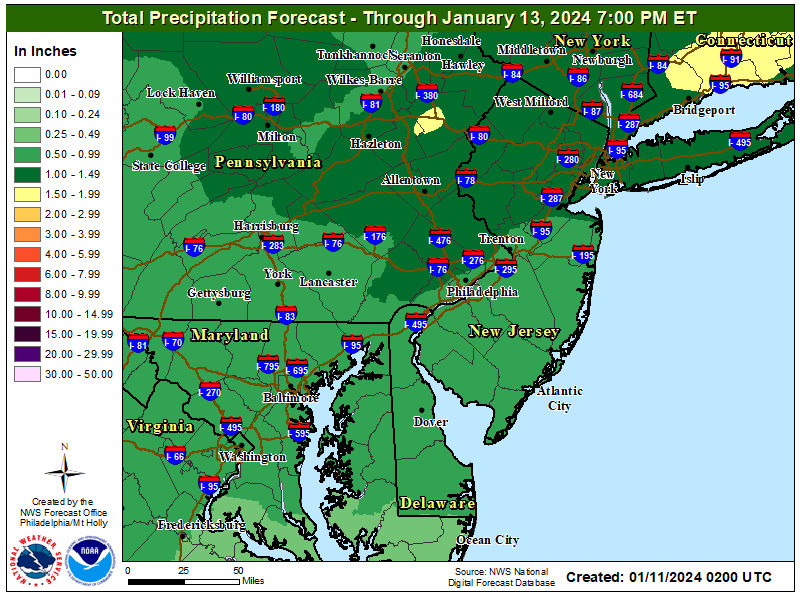
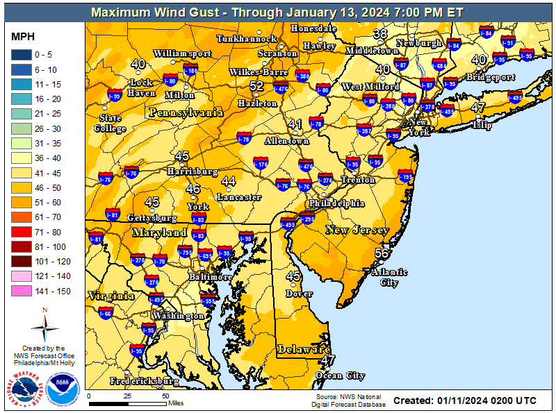
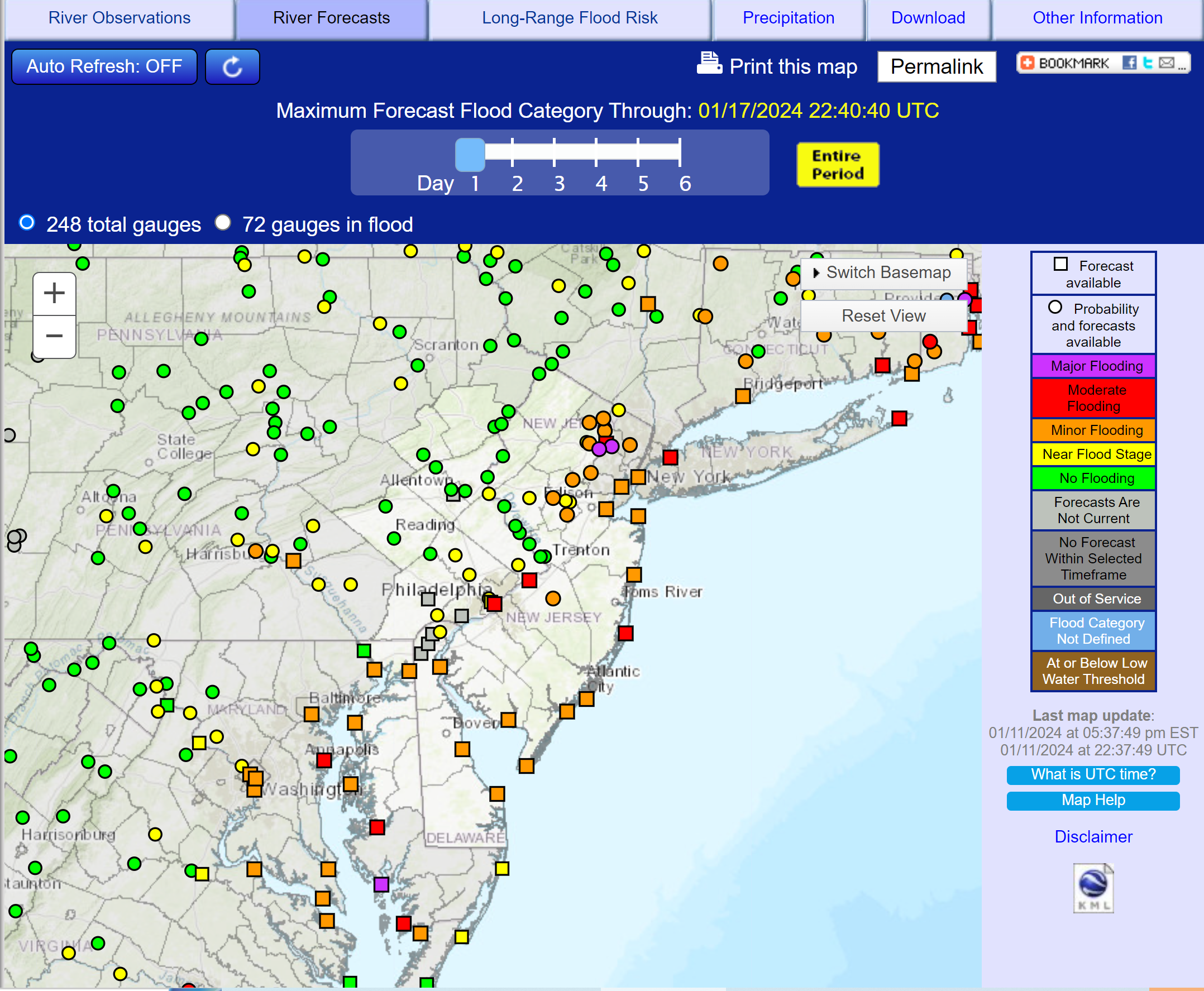
Here's the updated rainfall forecast for Friday night/early Saturday. If you look at the grids, this is actually a general 0.75-1.5" with maxes to 2" in spots, as about half of the models are showing up to 2" especially for NNJ/SENY (N of 78). And also the updated max wind gust forecast is below - a bit lower winds than last night. Lastly, the flood potential is generally a bit less severe than this past storm, except for the Passaic, which might stay in major flood stage through the next storm.


How can one even argue with you if you're incapable of even responding to the correct post. You're ranting about my post saying 1-2" of rain, generally. Maybe take a timeout from posting.Relent? You’re more apt to see hell freeze over Merck …LOL…Admit it you were wrong and you will play this silly… my reading comp BS… typical of you and the AH I put on ignore just knew he would join in . I never relent funny thing is you are exactly the same. I didn’t tell you not to post and predict or warn about impending doom… that is your way… this was a nothing event. There are far more worse ones coming and you can get your props from your boys on this board. You do realize you are a smug individual… enjoy playing weatherman.
*Please* stop feeding this troll! You're doing exactly what he wants by responding to him. There is an old saying -- I've quoted it before -- that dogs and children prefer negative attention to no attention. He's one or the other if not both.lol, I'm actually trying to help you see how distorted your perception is. Let's just take one simple element of what you just said above, where you said, "I never said you fear Mother Nature." True? Ok, then how do you square that with this quote from a couple of posts ago from you: "I guess you lived a very sheltered life protected and made to fear not respect Mother Nature." You contradict yourself all the time and don't even recognize it or just choose to ignore it. Until you actually start reading and thinking, you'll continue to make a mess of things.
And just for giggles, please show your work regarding what I was wrong on with my posts on expected rainfall, flooding, winds or anything else. Hint - you can't as they were all spot on, because the NWS knows what it's doing and I shared their info.
I've had this particular gentleperson on "ignore" for a long time, and there's a good reason for it. The only way to shut him up is to ignore him.
I've been wondering how you are doing, and glad to see you inject a sense of calm and good advice here.*Please* stop feeding this troll! You're doing exactly what he wants by responding to him. There is an old saying -- I've quoted it before -- that dogs and children prefer negative attention to no attention. He's one or the other if not both.
I've had this particular gentleperson on "ignore" for a long time, and there's a good reason for it. The only way to shut him up is to ignore him.
I usually do and I've usually been ignoring other troll posts in active weather threads (to avoid derailing them), but this one is basically over, so I'm indulging in arguing for sport, which I will do at times.*Please* stop feeding this troll! You're doing exactly what he wants by responding to him. There is an old saying -- I've quoted it before -- that dogs and children prefer negative attention to no attention. He's one or the other if not both.
I've had this particular gentleperson on "ignore" for a long time, and there's a good reason for it. The only way to shut him up is to ignore him.
I am doing fine -- thank you so much for asking. I haven't posted in a while and intend to keep it that way. (I violated my principles by posting, but I don't want this thread derailed -- the subject matter is too important. )I've been wondering how you are doing, and glad to see you inject a sense of calm and good advice here.
A lot of people here are very nice and fun to correspond with, but the bad ones spoil it for everyone -- well, at least for me. The killer for me was when some asshole (I won't mention his name because he doesn't deserve attention) gave me a hard time for asking for help even when I explained why I needed it.
It's not just this board; people hide behind their anonymity on chatboards to behave in ways they never would in "real life" for fear of having their lights punched out. For whatever reason, the "management" (both on this board and elsewhere) is unwilling to curb this kind of bad behavior.
Tuesday still tending snow?
Cold enough for snow but pretty dry
It's everywhere, and I strive to find a happy place. A lot of people say X (formerly Twitter) is a bad/toxic place full of bad people. Well, so is the world, and just like in real life, I cull a select list of people with whom I interact and share thoughts, and when mean person tries to start trouble, I ignore them. Like all people, sometimes I engage these people, but later regret it. But for the most part, I seek out and interact with positive people of diverse viewpoints.I am doing fine -- thank you so much for asking. I haven't posted in a while and intend to keep it that way. (I violated my principles by posting, but I don't want this thread derailed -- the subject matter is too important. )
A lot of people here are very nice and fun to correspond with, but the bad ones spoil it for everyone -- well, at least for me. The killer for me was when some asshole (I won't mention his name because he doesn't deserve attention) gave me a hard time for asking for help even when I explained why I needed it.
It's not just this board; people hide behind their anonymity on chatboards to behave in ways they never would in "real life" for fear of having their lights punched out. For whatever reason, the "management" (both on this board and elsewhere) is unwilling to curb this kind of bad behavior.
X has been a particularly wonderful source of medical, health and exercise information, but it take discipline to ignore the noise in that space.
As for here, most of the people have good intentions. We all have our things we disagree on, but we are not going to convince random strangers on the internet to agree to our view point. The interesting thing is that there are several people on these boards who are actually very nice people in person, but their postings here might lead one to conclude otherwise. Such is the nature of what I call the antisocial aspect of social media.
This board is wonderful and tame compared to real social media. That's some scary and wild stuff, especially for younger people.I am doing fine -- thank you so much for asking. I haven't posted in a while and intend to keep it that way. (I violated my principles by posting, but I don't want this thread derailed -- the subject matter is too important. )
A lot of people here are very nice and fun to correspond with, but the bad ones spoil it for everyone -- well, at least for me. The killer for me was when some asshole (I won't mention his name because he doesn't deserve attention) gave me a hard time for asking for help even when I explained why I needed it.
It's not just this board; people hide behind their anonymity on chatboards to behave in ways they never would in "real life" for fear of having their lights punched out. For whatever reason, the "management" (both on this board and elsewhere) is unwilling to curb this kind of bad behavior.
This board is wonderful and tame compared to real social media. That's some scary and wild stuff, especially for younger people.
Tik tok should be banned and its destroying music
Never signed up for any social media besides LinkedIn. Very happy that I stuck with this decision. My wife has FB, so I get to keep up with family and friends. Our little one is entering her tween/middle school years, so it's game time to keep her protected while not making her a social outcast. It's a tough balance.It's everywhere, and I strive to find a happy place. A lot of people say X (formerly Twitter) is a bad/toxic place full of bad people. Well, so is the world, and just like in real life, I cull a select list of people with whom I interact and share thoughts, and when mean person tries to start trouble, I ignore them. Like all people, sometimes I engage these people, but later regret it. But for the most part, I seek out and interact with positive people of diverse viewpoints.
X has been a particularly wonderful source of medical, health and exercise information, but it take discipline to ignore the noise in that space.
As for here, most of the people have good intentions. We all have our things we disagree on, but we are not going to convince random strangers on the internet to agree to our view point. The interesting thing is that there are several people on these boards who are actually very nice people in person, but their postings here might lead one to conclude otherwise. Such is the nature of what I call the antisocial aspect of social media.
Define "real" social media. Tik Tok? Instagram? X?This board is wonderful and tame compared to real social media. That's some scary and wild stuff, especially for younger people.
As I noted above, a social media platform is what you make of it. You can engage and rage, or ignore and bore. "Most" (ha ,ha), I read through and don't engage. I enjoy the quarterback, passing game, recruiting discussions. I have no interest in discussing politics with strangers, and I am happy to not have access to the CE Board.
Seriously, I would ban all social media for minors. It's shocking how unprepared and unable kids are with understanding and processing this garbage.Tik tok should be banned and its destroying music
FB seems to have gone the way of the dinosaur. I rarely, if ever log on. Instagram is, I suppose, the modern version of Facebook (owned by Meta). I have an account there, but only follow a few select close friends and fire departments in my region to keep up on what's going on in the are with other fire departments. I don't think I have ever posted on Instagram, and I don't think I ever will.Never signed up for any social media besides LinkedIn. Very happy that I stuck with this decision. My wife has FB, so I get to keep up with family and friends. Our little one is entering her tween/middle school years, so it's game time to keep her protected while not making her a social outcast. It's a tough balance.
I have really enjoyed X (Twitter), but I know a lot of people who think it is a cesspool, but it is what you make of it. I screened out all the stinky (to me) stuff and get what I need there. I get a ton of great info from MDs, dieticians, exercise people, longevity people, etc. I also follow several people who remarkably improved their lives midlife with diet and exercise. As I said above, it's a pretty happy place for me. But like here, there are people who are constantly in fights. Life's too short for negative energy.
Yes, as a fully formed adult you can manage real social media properly. Kids have no chance. TT, X, SNAP, FB/Reels, Instagram, YouTube Shorts.....I'm sure I'm missing a few.Define "real" social media. Tik Tok? Instagram? X?
As I noted above, a social media platform is what you make of it. You can engage and rage, or ignore and bore. "Most" (ha ,ha), I read through and don't engage. I enjoy the quarterback, passing game, recruiting discussions. I have no interest in discussing politics with strangers, and I am happy to not have access to the CE Board.
I guess X can be okay if you follow any professionals you are interested in and are able to hide or deactivate the comments. However, most people I respect and want to hear from have podcasts or other avenues to follow. So, never needed to jump on X.FB seems to have gone the way of the dinosaur. I rarely, if ever log on. Instagram is, I suppose, the modern version of Facebook (owned by Meta). I have an account there, but only follow a few select close friends and fire departments in my region to keep up on what's going on in the are with other fire departments. I don't think I have ever posted on Instagram, and I don't think I ever will.
I have really enjoyed X (Twitter), but I know a lot of people who think it is a cesspool, but it is what you make of it. I screened out all the stinky (to me) stuff and get what I need there. I get a ton of great info from MDs, dieticians, exercise people, longevity people, etc. I also follow several people who remarkably improved their lives midlife with diet and exercise. As I said above, it's a pretty happy place for me. But like here, there are people who are constantly in fights. Life's too short for negative energy.
Thankfully, my two "kids" 23 and 20, did fine with social media, but social media keeps evolving. The older one is working for a large medical software company as a software developer and is doing great. The younger one is in year 3 of a PA program, and he is crushing life and having a great college experience. My better half deserves a lot of the credit, but we must have done something right.Yes, as a fully formed adult you can manage real social media properly. Kids have no chance. TT, X, SNAP, FB/Reels, Instagram, YouTube Shorts.....I'm sure I'm missing a few.
No… you actually posted 3 consecutive posts on the same topic. I originally was poking at your weather forecast simply because of the usage of the word HELLACIOUS which made it sound as though this storm was similar to many others which come up the coast. Was it a strong storm yes. Was it over hyped like most are in today’s news yes. Were you trying to help sure I understood that completely. The fear factor does not help anyone. You enjoy weather and we enjoy reading the updates posted but as it turns out it was nothing greater than what we have witnessed in are lifetime.How can one even argue with you if you're incapable of even responding to the correct post. You're ranting about my post saying 1-2" of rain, generally. Maybe take a timeout from posting.
Not much forecast change for Friday night's event (updated rainfall forecast below), apart from some good news that with <1.5" of rain expected for CNJ, the predicted flooding forecast for the various Raritan River gauges (including North/South Branch, Manville, Bound Brook, Millstone, etc.) has all of these gauges remaining in the minor flooding or less categories, not moderate or major. The Passaic River is the only one expected to be in major flood stage from Friday's storm, while the Pompton and Saddle Rivers are only expected to see minor flooding (they saw major flooding on Tues/Weds).Here's the updated rainfall forecast for Friday night/early Saturday. If you look at the grids, this is actually a general 0.75-1.5" with maxes to 2" in spots, as about half of the models are showing up to 2" especially for NNJ/SENY (N of 78). And also the updated max wind gust forecast is below - a bit lower winds than last night. Lastly, the flood potential is generally a bit less severe than this past storm, except for the Passaic, which might stay in major flood stage through the next storm.


Still expecting 40-50 mph gusts inland and 50-60 mph gusts along the coast (less than the last storm, but still substantial with some power outages likely). There will also likely only be minor coastal flooding with this system along the Atlantic coast, but there could be moderate flooding along the Delaware and Hudson tidal areas from this system.
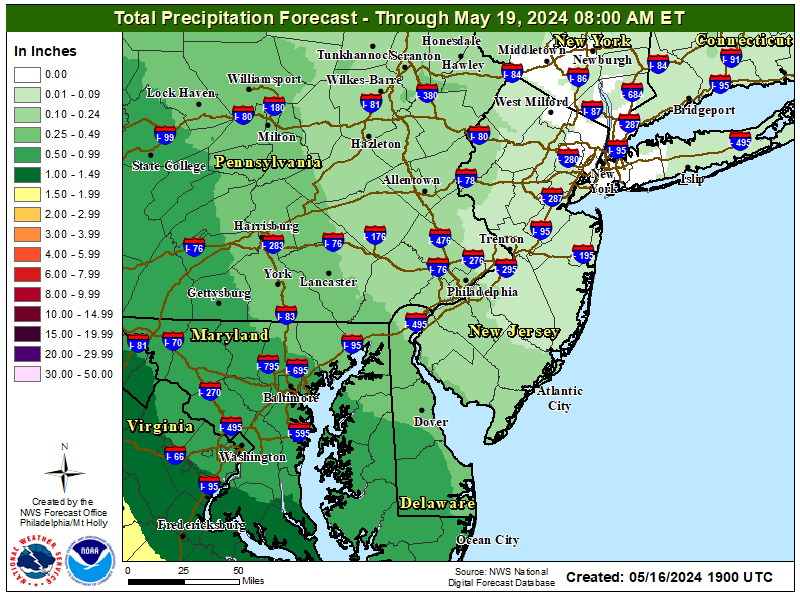
https://www.weather.gov/images/erh/gis/PHI_QPF.png
Updated the thread title to include Friday's round 2 in this thread, since impacts should be somewhat less, meaning I'd expect a fair amount less posting on the storm, so I didn't bother with a new thread. @e5fdny may have to send his goons after me, lol.
Will start a snowstorm threat thread for next Tuesday if today's models continue to be somewhat bullish for accumulating snow, as is the NWS, as per their discussion this morning, below. The Euro has been consistently showing a moderate to significant snowfall, while the GFS/CMC have been bouncing around with wildly changing solutions (some with snow, some not). The biggest question this time might not be snow vs. rain, but high pressure suppression forcing the storm well to our south. Still 5 days out so many questions...
Looking towards the beginning of the week guidance is showing a
deep 250mb trough swinging through the central US. This sends a
strong 250mb jet over the region and guidance has shown the
potential for some weak cyclogensis to our south. The consensus
amongst guidance is that a low pressure system will form to our
south and stays to the south as it moves towards the northeast.
This keeps the forecast area entirely in the cold sector of the
system and in the right rear quad of the 250mb jet. That should
lead to broad synoptic lift and with moisture in place we may
see accumulating snow across the region. Based on the 18z
ensembles that went into the 01z NBM, the nearly the entire
forecast area has 50% chance of exceeding 1" of snow and given
the area would be in the cold sector there would be no immediate
rainfall to melt the snow. At this point limiting factors would
be the speed of the system rather than thermal profiles.
I guess X can be okay if you follow any professionals you are interested in and are able to hide or deactivate the comments. However, most people I respect and want to hear from have podcasts or other avenues to follow. So, never needed to jump on X.
Youtube is great for podcasts
+1Youtube is great for podcasts
I like watching podcasts vs. only listening to them.
I was notified.Updated the thread title to include Friday's round 2 in this thread, since impacts should be somewhat less, meaning I'd expect a fair amount less posting on the storm, so I didn't bother with a new thread. @e5fdny may have to send his goons after me, lol.
Will start a snowstorm threat thread for next Tuesday if today's models continue to be somewhat bullish for accumulating snow, as is the NWS, as per their discussion this morning, below. The Euro has been consistently showing a moderate to significant snowfall, while the GFS/CMC have been bouncing around with wildly changing solutions (some with snow, some not). The biggest question this time might not be snow vs. rain, but high pressure suppression forcing the storm well to our south. Still 5 days out so many questions...
Looking towards the beginning of the week guidance is showing a
deep 250mb trough swinging through the central US. This sends a
strong 250mb jet over the region and guidance has shown the
potential for some weak cyclogensis to our south. The consensus
amongst guidance is that a low pressure system will form to our
south and stays to the south as it moves towards the northeast.
This keeps the forecast area entirely in the cold sector of the
system and in the right rear quad of the 250mb jet. That should
lead to broad synoptic lift and with moisture in place we may
see accumulating snow across the region. Based on the 18z
ensembles that went into the 01z NBM, the nearly the entire
forecast area has 50% chance of exceeding 1" of snow and given
the area would be in the cold sector there would be no immediate
rainfall to melt the snow. At this point limiting factors would
be the speed of the system rather than thermal profiles.
Feel free to start your car. Don’t worry about a thing. 😐

Why not? You don't want those doing the baiting to qualify as master-baiters?Don't take the bait, Numbers.
Why not? You don't want those doing the baiting to qualify as master-baiters?
I think he's espousing a policy of abatement.
Well we all know mildone is a master baiter with a short stroke 😜I think he's espousing a policy of abatement.
there was still some minor flooding today in parts
1.5 inches of rain will not be good for those around the flood prone areas in somerset county
1.5 inches of rain will not be good for those around the flood prone areas in somerset county
Wait… who buys property near (all the high water table ) rivers and streams of NJ… It’s not very bright it would seem actually dumb. The best is the flooding for the most parts occurs in the exact same areas it did since the 1950’s . The problem was supposed to have been worked on after Super Storm Sandy but like everything else all those flood plain areas have not really changed much. Barnegat , Passaic River, Raritan River. Little Falls , Lincoln Park Wayne, Rt# 23 . Your good Jersey tax dollars were well spent. Classic NJ hard at work.
No it won't but at least the river forecasts are for only minor flooding this time for the Raritan Basin waterways in CNJ. The only river still forecast for major flooding is the Passaic at Little Falls and Pine Brook. The tidal Delaware is still forecast to hit moderate flooding in a few spots, but other than that river flooding looks to be minor in most locations in PA, NJ, and NY. There are forecasts for moderate coastal flooding with Saturday morning's high tide in Barnegat and on LI.there was still some minor flooding today in parts
1.5 inches of rain will not be good for those around the flood prone areas in somerset county
- Status
- Not open for further replies.
Similar threads
- Replies
- 152
- Views
- 7K
- Replies
- 472
- Views
- 19K
- Replies
- 74
- Views
- 2K
- Replies
- 488
- Views
- 21K
ADVERTISEMENT
ADVERTISEMENT
