I'm in Boston where they're supposed to get a foot of snow, w/the heaviest bands coming down between 5 am - 1 pm. I have an Acela train back down to NJ at 11 am - any insights on if they run during snow, or should I be expecting delays / cancellations?
Colleges
- American Athletic
- Atlantic Coast
- Big 12
- Big East
- Big Ten
- Colonial
- Conference USA
- Independents (FBS)
- Junior College
- Mountain West
- Northeast
- Pac-12
- Patriot League
- Pioneer League
- Southeastern
- Sun Belt
- Army
- Charlotte
- East Carolina
- Florida Atlantic
- Memphis
- Navy
- North Texas
- Rice
- South Florida
- Temple
- Tulane
- Tulsa
- UAB
- UTSA
- Boston College
- California
- Clemson
- Duke
- Florida State
- Georgia Tech
- Louisville
- Miami (FL)
- North Carolina
- North Carolina State
- Pittsburgh
- Southern Methodist
- Stanford
- Syracuse
- Virginia
- Virginia Tech
- Wake Forest
- Arizona
- Arizona State
- Baylor
- Brigham Young
- Cincinnati
- Colorado
- Houston
- Iowa State
- Kansas
- Kansas State
- Oklahoma State
- TCU
- Texas Tech
- UCF
- Utah
- West Virginia
- Illinois
- Indiana
- Iowa
- Maryland
- Michigan
- Michigan State
- Minnesota
- Nebraska
- Northwestern
- Ohio State
- Oregon
- Penn State
- Purdue
- Rutgers
- UCLA
- USC
- Washington
- Wisconsin
High Schools
- Illinois HS Sports
- Indiana HS Sports
- Iowa HS Sports
- Kansas HS Sports
- Michigan HS Sports
- Minnesota HS Sports
- Missouri HS Sports
- Nebraska HS Sports
- Oklahoma HS Sports
- Texas HS Hoops
- Texas HS Sports
- Wisconsin HS Sports
- Cincinnati HS Sports
- Delaware
- Maryland HS Sports
- New Jersey HS Hoops
- New Jersey HS Sports
- NYC HS Hoops
- Ohio HS Sports
- Pennsylvania HS Sports
- Virginia HS Sports
- West Virginia HS Sports
ADVERTISEMENT
You are using an out of date browser. It may not display this or other websites correctly.
You should upgrade or use an alternative browser.
You should upgrade or use an alternative browser.
OT: Probable Wintry Mix to Rain for Most on 2/24-25 (but more wintry N/W)
- Thread starter RU848789
- Start date
I've brought this up before. Wind during cycling sucks. The last few years most days seem like its 10mph or more everyday. Can't remember the last completely calm day. Rode last Saturday to AC from Hammonton with 20mph side winds and 30+ gusts and it was borderline dangerous.It's not the cold or snow that seems out of place to me over the past year or two, it's the crazy winds.
It seems more than I can ever remember in the nearly 30 years I've been down here 25+ has become the norm with hitting the rare 50 mark has become at least a bi-monthly event even in the Spring and Fall.
Is there a site that tracks that #s? I'd really like to see if that's confirmed or if it's just because I'm just noticing it more.
My brother in law left a really nice bike for me to use during the "off season". Like you said, the problem is the constant high winds make it really difficult for someone like me who just likes to take leisurely cruises around the area. It seems we're experiencing small craft warnings every day with gale warnings almost as often which being so close means we get the winds on shore.I've brought this up before. Wind during cycling sucks. The last few years most days seem like its 10mph or more everyday. Can't remember the last completely calm day. Rode last Saturday to AC from Hammonton with 20mph side winds and 30+ gusts and it was borderline dangerous.
I checked back and we're had winds over 40mph 7 or 8 times since Thanksgiving, Didn't bother looking at 25+ because I can't count that high lol.
After enjoying the beautiful day, having a nice outdoor lunch with my wife, then playing a fun round of disc golf at NJ's new "monster" course (The Grove in Manalapan - it's the hardest course in NJ now), I had to witness that hoops debacle, so not much energy for weather.
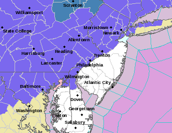
Today's models have been flip-flopping a fair amount from the 12Z runs around noon to the 18Z runs in the early evening to the 0Z runs coming out now, which is why I think the NWS is kind of looking at a model blend in order to hedge their bets. Updated maps from 4 pm are below, but keep in mind there are some models showing more or less snow, sleet, and freezing rain than what's depicted, i.e., uncertainty is still very high.
The NWS did extend the watch to Morris, Lehigh and Berks. I'm guessing tomorrow morning the NWS will have warnings up for the Poconos and Sussex and maybe advisories for the rest of the watch counties (Warren, Lehigh Valley, W. Passaic, W. Bergen and the Hudson Valley, and will probably extend advisories down to at least the counties along 276/195, primarily for the risk of a bit of snow/sleet and up to 0.1" of freezing rain along/near 276/195 (and maybe even for SEPA/SNJ given the risk of a glaze of ice before sunrise in those areas).
The most concerning thing is that about half the models are showing 1/4" or more of freezing rain accretion for much of CNJ/NNJ/NYC/EPA with much of that coming in the early morning hours and into the rush hour, after maybe an inch or so of snow sleet for areas from 276/195 to 78 and 2-3" of snow/sleet between 78 and 80. That much freezing rain could be a real problem. Hopefully, we'll see more model consensus develop by tomorrow's 12Z runs around noon. In areas where temps remain at or below 32F through 7-8 am (could be as far south as the Raritan/202), the morning rush hour could be a mess.
https://www.weather.gov/phi/
https://www.americanwx.com/bb/topic/56854-february-2425-potential-winter-storm/page/27/
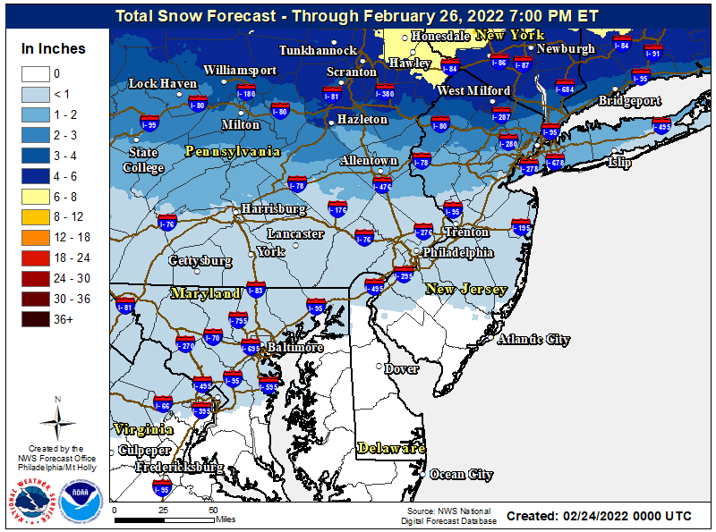
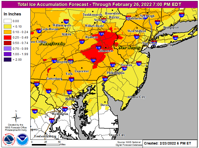
The 0Z runs last night were a tick warmer/wetter, overall, so the NWS-Philly only issued advisories for the 95 corridor (the SE PA counties along the Delaware to Mercer and Middlesex) and all counties NW of there, while the NWS-NYC issued advisories for almost their entire area (NYC, the northern half of LI, CT, NENJ from Union up to Bergen, and the Hudson Valley). Note that most of the snow/sleet being forecast will likely be sleet, especially south of 80 and remember, 1" of sleet has the frozen mass of 3" of snow, so it might not look like much, but will have similar road and snow removal impacts of 3" of snow.
Also, if the models trend any warmer, the snow/sleet/freezing rain forecasts will have to be trimmed back further with less impacts. This will be a very close call for so many, especially along/near 95, as a difference of 1F aloft and/or at the surface over a few hours could mean the difference between a slushy/icy mess and plain rain. The advisories essentially call for the following:
- For Newcastle, Delaware and Philadelphia counties, the advisories are mainly for the risk of up to 0.1" of freezing rain accretion (with little to no snow/sleet) during the overnight hours before 4 am, after which temps will go above freezing and 1/2" to 1" of rain will fall.
- For counties along 95, i.e,. Chester, Montgomery, Bucks, Mercer and Middlesex the forecast is for up to 1" of snow/sleet, followed by 0.1-0.2" of freezing rain accretion from about 10 pm to 5-6 am, when the temp is forecast to finally go above 32F, leading to all rain (with ~1/2" of plain rain after that), which might mean the morning rush hour is ok, but this is a really close call, as temps won't rise quickly, so roads could still be slushy through 7-8 am.
- For the next tier of counties NW of 95 and N of 276, i.e., Upper Bucks, Hunterdon and Somerset the forecast is for 1-2" of sleet/snow, followed by up to 1/4" of freezing rain accretion through 7-8 am, when the precip should change to rain, especially S of 202 (freezing rain could hold on til late morning N of 202 and especially N of 78); the morning rush hour will likely be impacted for these counties.
- For the Lehigh Valley (Berks, Lehigh, Northampton) and Morris/Warren, the forecast is for 1-3" of snow/sleet followed by up to 1/4" of freezing rain, mostly after 5 am; in these counties there may not be a changeover to plain rain at all, especially in the NW portions of these counties; clearly these counties should have significant morning rush hour impacts.
- For Carbon/Monroe and Sussex Counties, the forecast is for 2-5" of snow/sleet, followed by up to 1/4" of freezing rain, with temps likely never going above 32F, so rush hour impacts will be substantial.
- For the NWS-NYC area, the forecast for NW Passaic, N Bergen, the Hudson Valley N of NYC (Rockland/Westchester and N of there), and CT the forecast is for 2-4/3-6" of snow/sleet (the 3-6" amounts for the northern parts of that area), followed by 0,1-0.2" of freezing rain and no changeover to plain rain at all, so morning rush hour impacts would be substantial.
- Also in the NWS-NYC area, the advisories for Union/Essex/Hudson and lower Passaic/Bergen, as well as all of NYC and northern LI, call for 1-2" (with up to 3" possible for the northern parts of these areas) of snow/sleet, followed by up to 0.2" of freezing rain.
- Note that for areas N of 80, any changeover to rain will likely be after the morning rush hour, so the rush hour will likely be substantially affected, whereas for areas S of 80 (Union/Essex/Hudson and most of NYC and LI), a changeover to rain is likely in the mid-morning, so the rush hour is likely to be impacted significantly.
My brother in law left a really nice bike for me to use during the "off season". Like you said, the problem is the constant high winds make it really difficult for someone like me who just likes to take leisurely cruises around the area. It seems we're experiencing small craft warnings every day with gale warnings almost as often which being so close means we get the winds on shore.
I checked back and we're had winds over 40mph 7 or 8 times since Thanksgiving, Didn't bother looking at 25+ because I can't count that high lol.
Good reason to check out an ebike.
Hoping for all rain on this one. Gotta drive from Hamilton to Jersey City @ 5:30am tomorrow for a 7am start time. Hopefully the freezing stuff keeps shifting north!
Today's 12Z models ticked a bit warmer again, although probably not enough to drop any of the advisories - the differences will more likely be a bit less snow/sleet for everyone and more importantly that the changeover to plain rain will likely be by 4-5 am along the 95 corridor up through Woodbridge and as early as 6-7 am up to 78, including NYC/Newark, and as early as 9-10 am all the way up to 80, which is probably as far north as the plain rain makes it. All of these changeover times are a couple of hours earlier than currently being forecast and will certainly make for a less treacherous morning commute, especially south of 78. Let's see what the NWS and other forecasters say in the next hour or so.
The 0Z runs last night were a tick warmer/wetter, overall, so the NWS-Philly only issued advisories for the 95 corridor (the SE PA counties along the Delaware to Mercer and Middlesex) and all counties NW of there, while the NWS-NYC issued advisories for almost their entire area (NYC, the northern half of LI, CT, NENJ from Union up to Bergen, and the Hudson Valley). Note that most of the snow/sleet being forecast will likely be sleet, especially south of 80 and remember, 1" of sleet has the frozen mass of 3" of snow, so it might not look like much, but will have similar road and snow removal impacts of 3" of snow.
Also, if the models trend any warmer, the snow/sleet/freezing rain forecasts will have to be trimmed back further with less impacts. This will be a very close call for so many, especially along/near 95, as a difference of 1F aloft and/or at the surface over a few hours could mean the difference between a slushy/icy mess and plain rain. The advisories essentially call for the following:
https://www.weather.gov/phi/
- For Newcastle, Delaware and Philadelphia counties, the advisories are mainly for the risk of up to 0.1" of freezing rain accretion (with little to no snow/sleet) during the overnight hours before 4 am, after which temps will go above freezing and 1/2" to 1" of rain will fall.
- For counties along 95, i.e,. Chester, Montgomery, Bucks, Mercer and Middlesex the forecast is for up to 1" of snow/sleet, followed by 0.1-0.2" of freezing rain accretion from about 10 pm to 5-6 am, when the temp is forecast to finally go above 32F, leading to all rain (with ~1/2" of plain rain after that), which might mean the morning rush hour is ok, but this is a really close call, as temps won't rise quickly, so roads could still be slushy through 7-8 am.
- For the next tier of counties NW of 95 and N of 276, i.e., Upper Bucks, Hunterdon and Somerset the forecast is for 1-2" of sleet/snow, followed by up to 1/4" of freezing rain accretion through 7-8 am, when the precip should change to rain, especially S of 202 (freezing rain could hold on til late morning N of 202 and especially N of 78); the morning rush hour will likely be impacted for these counties.
- For the Lehigh Valley (Berks, Lehigh, Northampton) and Morris/Warren, the forecast is for 1-3" of snow/sleet followed by up to 1/4" of freezing rain, mostly after 5 am; in these counties there may not be a changeover to plain rain at all, especially in the NW portions of these counties; clearly these counties should have significant morning rush hour impacts.
- For Carbon/Monroe and Sussex Counties, the forecast is for 2-5" of snow/sleet, followed by up to 1/4" of freezing rain, with temps likely never going above 32F, so rush hour impacts will be substantial.
- For the NWS-NYC area, the forecast for NW Passaic, N Bergen, the Hudson Valley N of NYC (Rockland/Westchester and N of there), and CT the forecast is for 2-4/3-6" of snow/sleet (the 3-6" amounts for the northern parts of that area), followed by 0,1-0.2" of freezing rain and no changeover to plain rain at all, so morning rush hour impacts would be substantial.
- Also in the NWS-NYC area, the advisories for Union/Essex/Hudson and lower Passaic/Bergen, as well as all of NYC and northern LI, call for 1-2" (with up to 3" possible for the northern parts of these areas) of snow/sleet, followed by up to 0.2" of freezing rain.
- Note that for areas N of 80, any changeover to rain will likely be after the morning rush hour, so the rush hour will likely be substantially affected, whereas for areas S of 80 (Union/Essex/Hudson and most of NYC and LI), a changeover to rain is likely in the mid-morning, so the rush hour is likely to be impacted significantly.


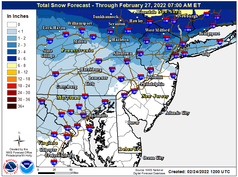
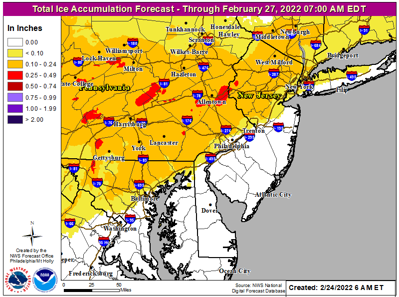
The NWS acknowledged the 12Z models being a tad warmer, but didn't change any of the advisory counties and instead simply decreased snowfall amounts and increased sleet amounts for just about everyone, while keeping the freezing rain forecast very similar and not ending the freezing rain significantly earlier than in this morning's forecast; not ending the freezing rain earlier surprised me a bit. See the maps below...
I still think the 95 corridor from Wilmington to Trenton will get very little sleet or freezing rain and any freezing rain will be over by about 3-4 am, so those area will likely have no rush hour impacts. For the 95 corridor from about Trenton to Woodbridge, there's a good chance that temps will be above 32F with plain rain falling by 5-6 am, which would minimize rush hour impacts for those areas. Also, anywhere in NJ more than 5-10 miles SE of the NJTPK will likely not get any frozen precip.
For areas between 202 and 78, freezing temps may last until 7-8 am, impacting the morning rush hour. And certainly, anywhere along and N of 78, from PA to at least Newark will likely see freezing temps until mid-morning with substantial rush hour impacts; NYC might just get away with temps going above 32F by 7 am, given the urban heat island effect and being east of Newark. N of 80 will likely still not get above 32F until noon or so when most of the precip will be over - their combo of snow, sleet and freezing rain will likely be pretty dangerous through rush hour. We likely won't see more than a few inches of pure snow until one gets N of 84, with the ski resorts in NY and New England on tap to get 8-12" of snow or more, as well as anywhere north of about a Binghamton to Boston line.
Freezing rain is nasty stuff and while I expect most major roads to be pretreated and likely ok, especially when heavily traveled, secondary roads and especially sidestreets, parking lots, sidewalks and driveways could be treacherous before sunrise almost everywhere and well into the rush hour for places along and N of 78. So be careful out there.
https://www.weather.gov/phi/
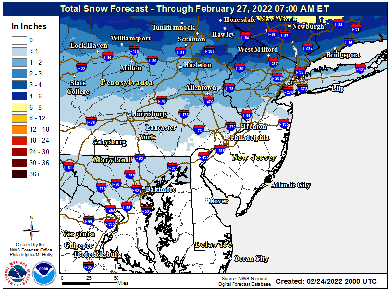
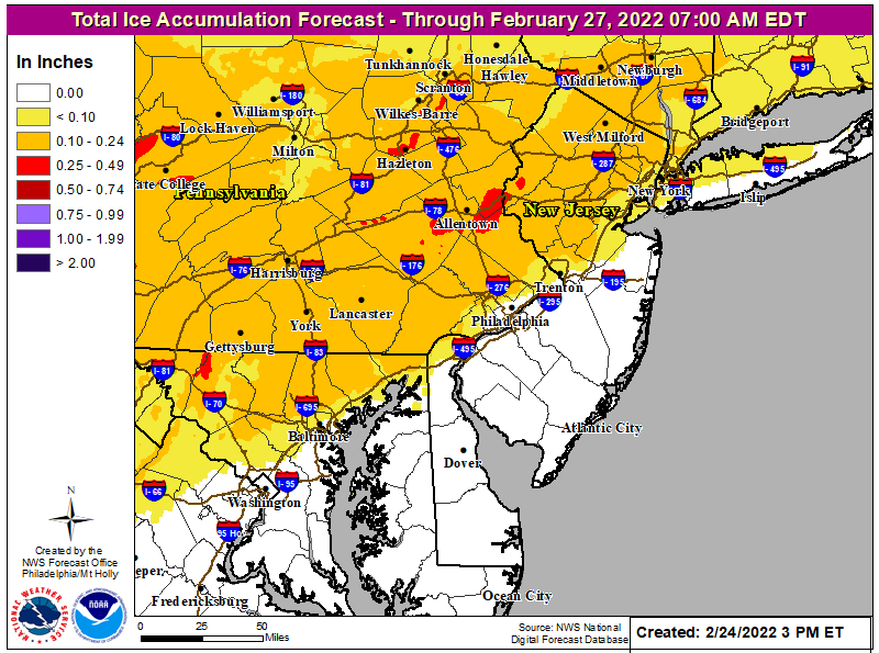
While I think it should not be an issue tomorrow morning, glad we switched to an afternoon flight. Thanks for the updates.The NWS acknowledged the 12Z models being a tad warmer, but didn't change any of the advisory counties and instead simply decreased snowfall amounts and increased sleet amounts for just about everyone, while keeping the freezing rain forecast very similar and not ending the freezing rain significantly earlier than in this morning's forecast; not ending the freezing rain earlier surprised me a bit. See the maps below...
I still think the 95 corridor from Wilmington to Trenton will get very little sleet or freezing rain and any freezing rain will be over by about 3-4 am, so those area will likely have no rush hour impacts. For the 95 corridor from about Trenton to Woodbridge, there's a good chance that temps will be above 32F with plain rain falling by 5-6 am, which would minimize rush hour impacts for those areas. Also, anywhere in NJ more than 5-10 miles SE of the NJTPK will likely not get any frozen precip.
For areas between 202 and 78, freezing temps may last until 7-8 am, impacting the morning rush hour. And certainly, anywhere along and N of 78, from PA to at least Newark will likely see freezing temps until mid-morning with substantial rush hour impacts; NYC might just get away with temps going above 32F by 7 am, given the urban heat island effect and being east of Newark. N of 80 will likely still not get above 32F until noon or so when most of the precip will be over - their combo of snow, sleet and freezing rain will likely be pretty dangerous through rush hour. We likely won't see more than a few inches of pure snow until one gets N of 84, with the ski resorts in NY and New England on tap to get 8-12" of snow or more, as well as anywhere north of about a Binghamton to Boston line.
Freezing rain is nasty stuff and while I expect most major roads to be pretreated and likely ok, especially when heavily traveled, secondary roads and especially sidestreets, parking lots, sidewalks and driveways could be treacherous before sunrise almost everywhere and well into the rush hour for places along and N of 78. So be careful out there.
https://www.weather.gov/phi/


Newark is right on the edge early tomorrow, IMO, so I think you made the right call. And thanks!!While I think it should not be an issue tomorrow morning, glad we switched to an afternoon flight. Thanks for the updates.
I think you might be right, as you guys might not go above 32F until mid-morning, at least.Got the call 90 minute delayed opening for tomorrow. Think it will eventually be cancelled.
2/27 is Sunday - they typically do 72 hour snowfall forecastsNow until Saturday?
Maps have a 2/27 date on them.
I think they run through a complete cycle giving you precip totals at the conclusion of the event. I don’t think the height of the precip will last that entire time. Weather people feel free to flog me if I have that wrong.Now until Saturday?
Maps have a 2/27 date on them.
Just checking.🧐2/27 is Sunday - they typically do 72 hour snowfall forecasts
And you know why. LOL
So far, the sleet and freezing rain (ZR) are overperforming with reports of significant sleet and ZR in MD, PA, and even northern DE and now into Philly and SNJ close to the Delaware River and SE PA and it's headed up the 95 corridor, so conditions could rapidly deteriorate along the NJ TPK and even 10-15 miles east of the TPK in CNJ and, of course NW of 95 in NJ/PA. This is not a surprise as all of the 0Z models trended a bit colder and icier recently.
TWC is actually calling for 0.1-0.25" of ZR for most of the 95 corridor and 1/4-3/4" of ZR not far NW of 95 in eastern PA (north of 276) and in NJ - that may be overstated, but there are several models that are showing that right now. That could be a major nightmare for overnight travel and could even lead to power outages. This graphic/discussion shows much of this. Hopefully, temps get above 32F anywhere near 95 by 5-6 am, limiting impact to just the overnight hours before rush hour, but the rush hour 10+ miles NW of 95 and especially N of 202 in NJ/PA will likely be impacted significantly with temps not going above 32F until mid morning for many.
We have a mix of sleet and freezing rain here that just started getting heavier and we already have some ice on cars and trees, but not on paved surfaces yet, but that will likely occur soon with temps at 31-32F.
https://www.spc.noaa.gov/products/md/md0186.html

Mesoscale Discussion 0186
NWS Storm Prediction Center Norman OK
0813 PM CST Thu Feb 24 2022
Areas affected...Parts of PA...far northeastern WV...far northern
VA...MD...and northern/western NJ
Concerning...Winter mixed precipitation
Valid 250213Z - 250715Z
SUMMARY...A mix of freezing rain and sleet will develop
northeastward into the overnight hours.
DISCUSSION...Latest water vapor imagery depicts a strong shortwave
trough and accompanying midlevel speed maximum advancing eastward
across parts of the Middle MS Valley. Ahead of the shortwave trough,
surface observations show pressure falls being maximized in the OH
vicinity, where a low pressure system will continue to develop over
the next several hours. As the cyclone deepens, increasing southerly
flow and related warm air advection will overspread the Central
Appalachians and Mid-Atlantic states, resulting in a gradual
increase in winter precipitation in the 03Z-08Z time frame.
Across the southern and central portion of the discussion area, RAP
forecast soundings show 850-mb temperatures increasing to 3-5 C atop
a shallow subfreezing layer, which will favor complete melting of
descending hydrometeors prior to refreezing near the surface. This
will result in primarily freezing rain, with rates as high as 0.05
in/hour owing to the strengthening forcing for ascent and deep-layer
moistening. With northward extent, observations and forecast
soundings show a deeper low-level subfreezing layer, with 850-mb
temperatures near 1-3 C, indicative of partial melting of
hydrometeors and the potential for sleet and freezing rain.
Farther north across northern PA, moderate snow is likely to develop
where deeper cold air is in place, with an eventual increase in
snowfall rates expanding northward into NY during the early morning
hours.
TWC is actually calling for 0.1-0.25" of ZR for most of the 95 corridor and 1/4-3/4" of ZR not far NW of 95 in eastern PA (north of 276) and in NJ - that may be overstated, but there are several models that are showing that right now. That could be a major nightmare for overnight travel and could even lead to power outages. This graphic/discussion shows much of this. Hopefully, temps get above 32F anywhere near 95 by 5-6 am, limiting impact to just the overnight hours before rush hour, but the rush hour 10+ miles NW of 95 and especially N of 202 in NJ/PA will likely be impacted significantly with temps not going above 32F until mid morning for many.
We have a mix of sleet and freezing rain here that just started getting heavier and we already have some ice on cars and trees, but not on paved surfaces yet, but that will likely occur soon with temps at 31-32F.
https://www.spc.noaa.gov/products/md/md0186.html

Mesoscale Discussion 0186
NWS Storm Prediction Center Norman OK
0813 PM CST Thu Feb 24 2022
Areas affected...Parts of PA...far northeastern WV...far northern
VA...MD...and northern/western NJ
Concerning...Winter mixed precipitation
Valid 250213Z - 250715Z
SUMMARY...A mix of freezing rain and sleet will develop
northeastward into the overnight hours.
DISCUSSION...Latest water vapor imagery depicts a strong shortwave
trough and accompanying midlevel speed maximum advancing eastward
across parts of the Middle MS Valley. Ahead of the shortwave trough,
surface observations show pressure falls being maximized in the OH
vicinity, where a low pressure system will continue to develop over
the next several hours. As the cyclone deepens, increasing southerly
flow and related warm air advection will overspread the Central
Appalachians and Mid-Atlantic states, resulting in a gradual
increase in winter precipitation in the 03Z-08Z time frame.
Across the southern and central portion of the discussion area, RAP
forecast soundings show 850-mb temperatures increasing to 3-5 C atop
a shallow subfreezing layer, which will favor complete melting of
descending hydrometeors prior to refreezing near the surface. This
will result in primarily freezing rain, with rates as high as 0.05
in/hour owing to the strengthening forcing for ascent and deep-layer
moistening. With northward extent, observations and forecast
soundings show a deeper low-level subfreezing layer, with 850-mb
temperatures near 1-3 C, indicative of partial melting of
hydrometeors and the potential for sleet and freezing rain.
Farther north across northern PA, moderate snow is likely to develop
where deeper cold air is in place, with an eventual increase in
snowfall rates expanding northward into NY during the early morning
hours.
It's pouring sleet out there right now - we got 1/4" of sleet in the last 30 minutes, which is 1.5" of snow equivalent per hour, roughly. Everything is covered and roads are very slick. Glad we're getting sleet instead of freezing rain (we got maybe a few hundredths of an inch of freezing rain between 1 and 1:30 am) and hopefully it'll be for awhile, but it is supposed to turn to freezing rain as the depth of the sub-32F cold air above the surface is supposed to shrink, meaning the falling raindrops, which are melting a few thousand feet up (from snow falling above that) will not have enough time to freeze into sleet pellets, but will, instead become supercooled and freeze on contact with the sub-32F surfaces (or the sleet on the ground). It's 31F still.
Fortunately, few people have to travel between now and 5-6 am, when I think we'll be above 32F along 95, allowing some melting to occur, although there will still likely be some slushy areas on the roads if temps don't go above 32F until 5-6 am (not everything melts magically at 33-34F, which is where it'll be through 8-9 am).
Fortunately, few people have to travel between now and 5-6 am, when I think we'll be above 32F along 95, allowing some melting to occur, although there will still likely be some slushy areas on the roads if temps don't go above 32F until 5-6 am (not everything melts magically at 33-34F, which is where it'll be through 8-9 am).
Back to mostly freezing rain at 31F with a few sleet pellets mixed in. Wondering if that's it for the sleet or not here. Already have probably 0.05" of ice accretion on trees - easiest place to estimate that, since the sleet didn't accumulate on the branches. Very slick out right now.It's pouring sleet out there right now - we got 1/4" of sleet in the last 30 minutes, which is 1.5" of snow equivalent per hour, roughly. Everything is covered and roads are very slick. Glad we're getting sleet instead of freezing rain (we got maybe a few hundredths of an inch of freezing rain between 1 and 1:30 am) and hopefully it'll be for awhile, but it is supposed to turn to freezing rain as the depth of the sub-32F cold air above the surface is supposed to shrink, meaning the falling raindrops, which are melting a few thousand feet up (from snow falling above that) will not have enough time to freeze into sleet pellets, but will, instead become supercooled and freeze on contact with the sub-32F surfaces (or the sleet on the ground). It's 31F still.
Fortunately, few people have to travel between now and 5-6 am, when I think we'll be above 32F along 95, allowing some melting to occur, although there will still likely be some slushy areas on the roads if temps don't go above 32F until 5-6 am (not everything melts magically at 33-34F, which is where it'll be through 8-9 am).
We've had freezing rain for the last few hours, but the precip has just let up quite a bit as a dry slot has hit most of CNJ/SNJ. Just looked closely at some small branches and I'd estimate between 0.10 and 0.15" of ice accretion. The freezing rain and the 1/4" or so of sleet that fell earlier have combined to make an icy/slushy mess on all surfaces.Back to mostly freezing rain at 31F with a few sleet pellets mixed in. Wondering if that's it for the sleet or not here. Already have probably 0.05" of ice accretion on trees - easiest place to estimate that, since the sleet didn't accumulate on the branches. Very slick out right now.
My driveway is extremely slippery as is the road in front of my house (very lightly traveled overnight) - watching some TV coverage and cams, the more heavily traveled major roads in the 95 corridorappear to be mostly wet but reports are that NW of here parts of roads like 78 and 287 are icier. It's still 31F here, but temps just SE of here in Old Bridge and Keyport are 33F so warmer air is finally getting down to the surface. I'd expect the 95 corridor to get above 32F by ~7 am, but it will take til mid-morning a bit NW of here. Time for some sleep...
Heavy rain overnight here in Philly. Nothing frozen. Saw the news of the Lehigh Valley, yikes.
Just got to Jersey City from Hamilton. The further north I went the more ice I saw. The turnpike was pretty well treated. Had a little bit of ice at home nothing major. Side roads in Jersey City are pretty slick.
Check your freezer. Same here.41 here so no ice
What happened there?Heavy rain overnight here in Philly. Nothing frozen. Saw the news of the Lehigh Valley, yikes.
While much of the state was having a delayed opening due to bad weather, the RU Rowing team was on the water at first light. Go RU!
Didn't expect to see that in the weather thread, but Go RU!While much of the state was having a delayed opening due to bad weather, the RU Rowing team was on the water at first light. Go RU!
Nice !While much of the state was having a delayed opening due to bad weather, the RU Rowing team was on the water at first light. Go RU!
What happened there?
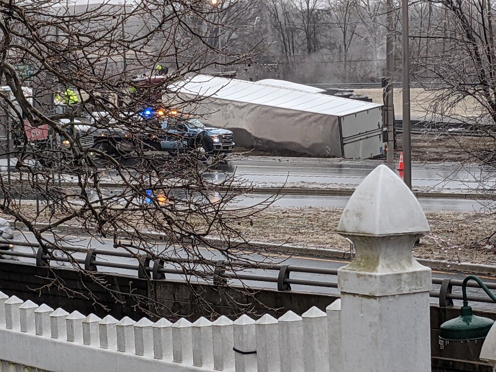
Basically, anywhere along and NE of 95 and north of 276 in PA and 195 in NJ got some sleet and freezing rain, like we did, but temps went above 32F for awhile diminishing rush hour impacts. However, anywhere along and N of 78 in PA and NJ got some sleet and significant freezing rain of 1/4-1/2" and remain below 32F, so they have icy conditions all over any untreated roads and lots of accidents. They even had two overturned tractor trailers on 78 near Clinton this morning, including the recent pic, below, from the 2nd overturned tractor trailer in Clinton which happened about 30 minutes ago in almost the same spot as the first.
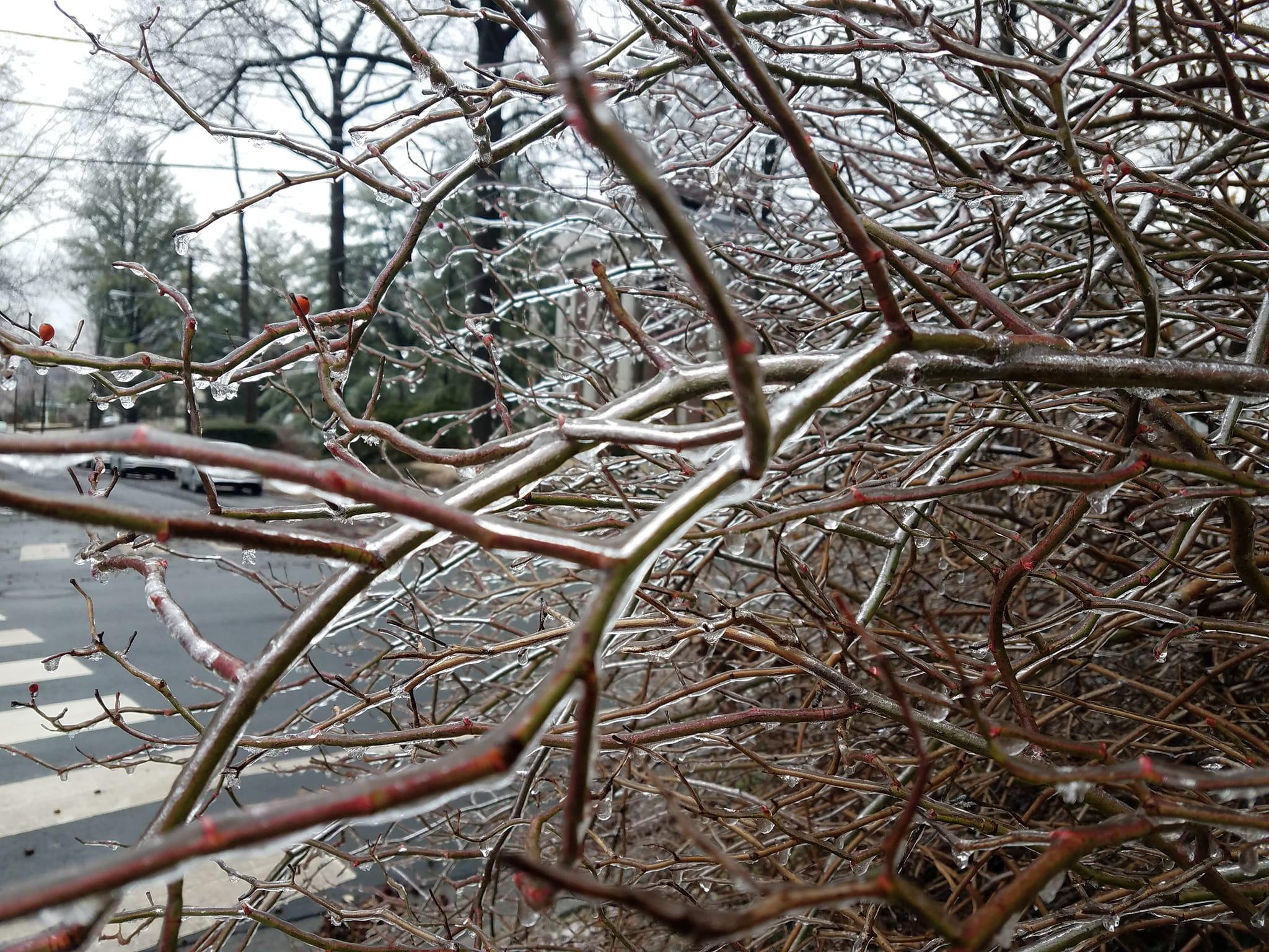
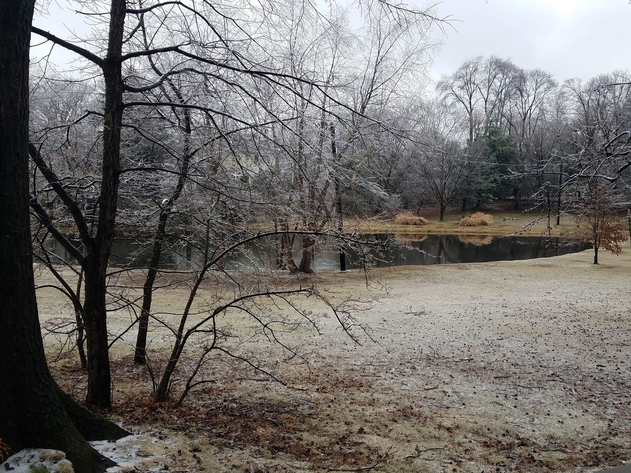
Along and near 95, like here in Metuchen, we were fortunate temps went above 32F from about 7-10 am (33-34F), allowing melting of the ice on paved surfaces (aided by the indirect sun), so my driveway/sidewalk and street in front of my house are now just wet, but temps have dropped back to 31-32F in the area and not much of the ice on the trees/cars melted, as per the pics. By my eyeball it looks like about 0.15-0.20" of ice accretion on branches (which probably was 1/4" at its worst). We had that on the paved surfaces this morning until at least 6 am when I fell asleep. Here are a couple of pics: a bush from my front yard showing the ice accretion and the view of the pond and trees across the street. Freezing rain is so dangerous, but you have to admit it's exquisitely beautiful to look at.
Last edited:
They're just gearing up for future post-office jobs for when climate change outcomes (i.e. "Waterworld") means most mail will be delivered by boat.While much of the state was having a delayed opening due to bad weather, the RU Rowing team was on the water at first light. Go RU!
"Neither snow nor rain nor heat nor gloom of night stays these couriers from the swift completion of their appointed rounds."
Or, you know, something like that.
Heavy rain overnight here in Philly. Nothing frozen. Saw the news of the Lehigh Valley, yikes.Num
Numerous reports of freezing rain between about 11 pm and 4 am in Philly with some ice accretion, but as far as I can tell, these folks were in NW or NE Philly, where it might have been just cold enough for the freezing rain, as opposed to Center City, where a few miles can make a difference. Same thing went on along 95 all the way up to our area, where folks 10 miles SE of the TPK barely got any freezing rain, while those of us right along the TPK got significant freezing rain and some sleet.
https://www.americanwx.com/bb/topic...erators-for-some-pre-emerg-for-others/page/8/
Iced out up at my place in NJ: school was closed as of 7AM, told the better half not to bother trying to go to work. She couldn't budge the ice anyway: the roads were okay, but the car was armored and the stairs/driveway had a thick sheet on it.
Yeah, it took some effort to open my car door this morning as it was seriously encased. I would've thought you guys would've had worse road conditions, at least on the local roads - a few folks in that area reporting slushy/icy local roads this morning.Iced out up at my place in NJ: school was closed as of 7AM, told the better half not to bother trying to go to work. She couldn't budge the ice anyway: the roads were okay, but the car was armored and the stairs/driveway had a thick sheet on it.
Similar threads
- Replies
- 44
- Views
- 2K
- Replies
- 131
- Views
- 5K
- Replies
- 74
- Views
- 2K
- Replies
- 488
- Views
- 21K
ADVERTISEMENT
ADVERTISEMENT