
Reread the title and first post. The first part of it is all about the generally warm, snowless weather through about 2/12 or so, so it's not like I'm ignoring it. And the next part about the coming pattern shift to probable cold/snowy weather isn't a buzzkill for me and I'm sure others. If it's a buzzkill for you, maybe skip the thread.We have two weeks of great weather (for winter) in front of us. Why be the buzzkill with this predicted pattern shift which may or may not happen? This thread was not a good idea.
Colleges
- American Athletic
- Atlantic Coast
- Big 12
- Big East
- Big Ten
- Colonial
- Conference USA
- Independents (FBS)
- Junior College
- Mountain West
- Northeast
- Pac-12
- Patriot League
- Pioneer League
- Southeastern
- Sun Belt
- Army
- Charlotte
- East Carolina
- Florida Atlantic
- Memphis
- Navy
- North Texas
- Rice
- South Florida
- Temple
- Tulane
- Tulsa
- UAB
- UTSA
- Boston College
- California
- Clemson
- Duke
- Florida State
- Georgia Tech
- Louisville
- Miami (FL)
- North Carolina
- North Carolina State
- Pittsburgh
- Southern Methodist
- Stanford
- Syracuse
- Virginia
- Virginia Tech
- Wake Forest
- Arizona
- Arizona State
- Baylor
- Brigham Young
- Cincinnati
- Colorado
- Houston
- Iowa State
- Kansas
- Kansas State
- Oklahoma State
- TCU
- Texas Tech
- UCF
- Utah
- West Virginia
- Illinois
- Indiana
- Iowa
- Maryland
- Michigan
- Michigan State
- Minnesota
- Nebraska
- Northwestern
- Ohio State
- Oregon
- Penn State
- Purdue
- Rutgers
- UCLA
- USC
- Washington
- Wisconsin
High Schools
- Illinois HS Sports
- Indiana HS Sports
- Iowa HS Sports
- Kansas HS Sports
- Michigan HS Sports
- Minnesota HS Sports
- Missouri HS Sports
- Nebraska HS Sports
- Oklahoma HS Sports
- Texas HS Hoops
- Texas HS Sports
- Wisconsin HS Sports
- Cincinnati HS Sports
- Delaware
- Maryland HS Sports
- New Jersey HS Hoops
- New Jersey HS Sports
- NYC HS Hoops
- Ohio HS Sports
- Pennsylvania HS Sports
- Virginia HS Sports
- West Virginia HS Sports
ADVERTISEMENT
OT: Will be warm (little/no snow) thru ~2/13, then a possible colder and snowier pattern
- Thread starter RU848789
- Start date
I think winter weather is a buzzkill to more on this board than you would think. To be fair, I think that most people don’t totally hate winter but the season just goes on too damn long. No one wants to see this pattern nonsense right now. And I’ll scroll which threads I wish thank you.Reread the title and first post. The first part of it is all about the generally warm, snowless weather through about 2/12 or so, so it's not like I'm ignoring it. And the next part about the coming pattern shift to probable cold/snowy weather isn't a buzzkill for me and I'm sure others. If it's a buzzkill for you, maybe skip the thread.

No one? The likes and positive feedback from at least a few say otherwise. I get more people hate snow than love it, but I just thought it was an interesting topic. You're obviously entitled to your opinion, though.I think winter weather is a buzzkill to more on this board than you would think. To be fair, I think that most people don’t totally hate wi.nter but the season just goes on too damn long. No one wants to see this pattern nonsense right now. And I’ll scroll which threads I wish thank you.
Whats amazing is he is bragging about a 2 -5 degree colder period while ignoring we have a plus 10 period coming up later in the week that may approach plus 20 for highs on Saturday with highs 60-65
Any normal person excited about weather would be touting that not a fantasy 21-28 day away snowstorm
Any normal person excited about weather would be touting that not a fantasy 21-28 day away snowstorm
He's going through snow-withdrawal and grasping at straws. It's been a rough 2 winters for snow wackos.Whats amazing is he is bragging about a 2 -5 degree colder period while ignoring we have a plus 10 period coming up later in the week that may approach plus 20 for highs on Saturday with highs 60-65
Any normal person excited about weather would be touting that not a fantasy 21-28 day away snowstorm
At least we got a smidge this season, so the kids got a little time sledding.
You're not paying attention either - I have touted it in the thread title and several posts and have been bantering about enjoying that weather here and in the other thread. Some of us are able to walk and chew gum at the same time. Also, our first winter storm threat is only 8+ days away as the pattern starts to change.Whats amazing is he is bragging about a 2 -5 degree colder period while ignoring we have a plus 10 period coming up later in the week that may approach plus 20 for highs on Saturday with highs 60-65
Any normal person excited about weather would be touting that not a fantasy 21-28 day away snowstorm
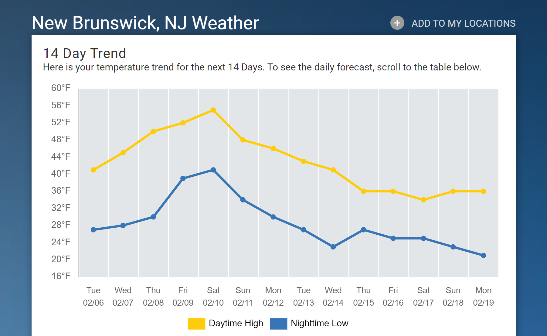
Here's the expected 14-day temperature trend for NB with the first 7-8 days pretty locked in showing temps going from near normal to well above normal from about Weds thru Sunday, peaking on Friday/Saturday with highs in the 50s. And while the forecast is always a bit less certain beyond 7-8 days, temperature trend forecasting is reasonably accurate out to 14 days and the graphic shows temps going back down to normal by about 2/13, as the pattern change starts and then going below normal by 2/15 and staying there.
So, get out and enjoy the gorgeous weather this week. Yesterday was spectacular for early Feb with highs 4-8F above normal, light winds and warm sunshine. My wife and I spent the afternoon in Westfield yesterday (ate at Ferraro's, yum, and walked around town doing some shopping) and it hit about 48F there with most CNJ locations seeing highs in the mid/upper 40s (Somerville hit 50F).
So, get out and enjoy the gorgeous weather this week. Yesterday was spectacular for early Feb with highs 4-8F above normal, light winds and warm sunshine. My wife and I spent the afternoon in Westfield yesterday (ate at Ferraro's, yum, and walked around town doing some shopping) and it hit about 48F there with most CNJ locations seeing highs in the mid/upper 40s (Somerville hit 50F).
That was only in the mountains of Wayne (right near the Fountains of Wayne); was a balmy 28F here this morning, lol. Up to a nice 42F here now and full sunshine.Warm my arse: it was 24° at 7:45 this morning when I checked the temp.
That was only in the mountains of Wayne (right near the Fountains of Wayne); was a balmy 28F here this morning, lol.
Now don't be dissin' Stacy's Mom!
She gets around - I heard she also frequents the Hillsborough Deli. By the way, for my money FoW was one of the most underrated power pop bands of the 90s and early 2000s. Got to know the lead singer a bit through his family as I worked with his brother and father some back then and they would go to shows too. Nice folks.Now don't be dissin' Stacy's Mom!
Warm your arse? What do you think this is? Hillsborough?Warm my arse: it was 24° at 7:45 this morning when I checked the temp.
Warm your arse? What do you think this is? Hillsborough?
Don't tease!
@RUPete ^^^^^
You see how hypersensitive he is? You have supported him all season, but one post with a little criticism and he freaks out on you.
Just saying. :)
Honestly, you two make me sad and disappointed. Your attitude reads more like a cartoonish Walmart Wolverine frat bully in an 80s movie than a Rutgers alumnus with any pride in yourself. Go pet a puppy or something to put some joy back in your life.Whats amazing is he is bragging about a 2 -5 degree colder period while ignoring we have a plus 10 period coming up later in the week that may approach plus 20 for highs on Saturday with highs 60-65
Any normal person excited about weather would be touting that not a fantasy 21-28 day away snowstorm
Thank you climate change!Whats amazing is he is bragging about a 2 -5 degree colder period while ignoring we have a plus 10 period coming up later in the week that may approach plus 20 for highs on Saturday with highs 60-65
Any normal person excited about weather would be touting that not a fantasy 21-28 day away snowstorm
Pattern change looks to be starting by 2/12, now, as evidenced by high latitude blocking (-NAO) establishing itself by then, as well as the movement of the major trough towards the eastern half of the US and the big ridge starting to establish itself in the PacNW. This is what's leading to the operational models now showing signs of a potential winter storm as early as late on 2/12 and into 2/13, which is now only a week away (i.e., the potential is real, not a fantasy any more); both last night's Euro and GFS show a sloppy winter storm for much of the eastern US including our area. Could easily still be a miss or mostly rain, but at least moderate accumulating snow is possible. Way too early for a thread - just showing the potential.
Once the cold and potentially snowy pattern is fully in place (not as much cold air in place before then, which is why the 2/12-13 threat could be rain/mix for many) by about 2/17-18, as per the ensemble models, which have not wavered at all in showing the pattern change for weeks, many of the medium range pro mets are talking about the week or two after that being the prime time for potential snowstorms. We'll see, of course - such patterns have failed in the past to deliver snow for our area, but they almost always deliver snow for someone in the eastern US (even for the SE US and usually for New England and the interior - unless we get suppression from too much confluence/cold air).
Once the cold and potentially snowy pattern is fully in place (not as much cold air in place before then, which is why the 2/12-13 threat could be rain/mix for many) by about 2/17-18, as per the ensemble models, which have not wavered at all in showing the pattern change for weeks, many of the medium range pro mets are talking about the week or two after that being the prime time for potential snowstorms. We'll see, of course - such patterns have failed in the past to deliver snow for our area, but they almost always deliver snow for someone in the eastern US (even for the SE US and usually for New England and the interior - unless we get suppression from too much confluence/cold air).
#'s...............
You can get all the snow you want, just keep it west and north of Exit 98 on the Parkway.
Deal?
You can get all the snow you want, just keep it west and north of Exit 98 on the Parkway.
Deal?
I would if I could, although I have Shore friends who want more cowbell and snow!#'s...............
You can get all the snow you want, just keep it west and north of Exit 98 on the Parkway.
Deal?
If we see the pattern/teleconnections I've been sharing from top pros, as per the quoted post, the chances of snowy conditions are clearly greater than is typical, as per the linked post, below, as DonSutherland from the weather boards, was finally able to compile the data on this. To summarize, the percentage of overall days with 2" of snow in NYC were 17% and the percentage of overall days with 4" or more was 17% for all February's between 1975 and 2023 (352 total days of 2 or 4" snowfalls out of 1352 total Feb days in 48 years), while for the pattern expected, with MJO Phases 1,8 (Amplitude 1.000 or above), AO-, EPO-, NAO-, PNA+, from February 1975-2023, the percentage of overall days with 2" of snow in NYC was 28% and the percentage of overall days with 4" or more was 18%. These numbers represent roughly a 60-80% enhancement for having those conditions in place vs. all other conditions in Feb in NYC, i.e., it's significantly more likely, but certainly not a foregone conclusion.We're now 2 days further along and all indications from the Euro/GFS/CMC ensemble model forecasts is that the pattern change being discussed is a go, probably starting a day or two earlier, i.e., by 2/13 (and maybe even 2/12), although the pattern likely won't be fully entrenched until about 2/15 and the coldest weather likely doesn't arrive until maybe 2/17 or so (and way too far out to predict any winter storms, although the period from about 2/18-2/27 does look to have greater snow chances than before 2/18). The operational models are also starting to show the pattern shift starting around 2/13 (with a chance of some wintry weather around then), which is now within ~9 days, which is no longer the fantasy land it was when I started the thread about 5 days ago.
As mentioned in the first post, the pattern generally features a persistent low/trough near the Aleutians, then a persistent ridge in the PacNW with the PacJet (subtropical jet stream) flowing clockwise around that high and diving down into the southwest (perhaps with some "split flow") and then heading up towards Greenland with a persistent trough in the eastern US and featuring high latitude "blocking" near Greenland (a negative NAO), allowing colder air to penetrate to our area and opening up the possibility for storms to traverse near that jet and coming up the coast, potentially delivering winter weather, which is why I'm predicting (educated guess really) from about 2/13 through the end of Feb to be colder and snowier than normal.
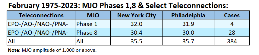
Since there isn't a lot of published data on what these patterns, as indicated by key MJO/teleconnections in the quoted thread above, actually mean for our area, I asked DonSutherland, the king of meteorological data on the weather boards (and maybe anywhere) to see if he could find data on what these patterns mean and he was able to find the data in the table below for average temperatures in February in Philly and NYC for patterns like we expect to have soon, i.e., EPO-/AO-/NAO-/PNA+ (he has a typo below on PNA) with both phase 1 and phase 8 of the critical MJO, as well as the base case of the overall mean temp. Clearly, for both cities, we can see departures of 3-5F below the historical overall mean, which certainly is "colder than normal" (colder than normal is typically at least 2F below the mean). Colder than normal does not mean extended brutal cold either, just, you know, below normal.
Unfortunately, Don wasn't able to find similarly robust data for snowfall for this kind of pattern in Feb, but he and just about every met I've seen say that such patterns typically do lead to snowier than normal outcomes, but definitely not in all cases; see the tweet below from John Homenuk (a very influential met) discussing how this kind of pattern has "delivered significant winter storms in the past." He and others have also said the heart of the colder (and potentially snowy) pattern is likely to be from 2/17 onwards. Also, as I've mentioned before, I've tracked about 8 fairly similar patterns since 2016 and saw that all 8 verified for colder than normal temps and 5 verified for snowier than normal outcomes (one would expect random guessing to verify 2-3 out of 8) for the 2-3 week periods I was following (did this for New Brunswick and vs. above/normal/below for those two parameters vs. all seasons for the period in question), but that's a fairly small sample size and I didn't rigorously track the teleconnections beyond what was forecast about 8-10 days out, so it would be nice to see someone out there in the weather world obtaining more rigorous data.
Hopefully, this will be interesting and fun to follow over the next few weeks for those of you who don't think the entire effort is a waste of time. I would think people might be interested in a likely cold/snowy pattern for the 2nd half of Feb and maybe into the first half of March. People seem to like the tropical weather seasonal forecast threads, which do the same thing, predicting normal, below normal and above normal seasons - without even any insight on where those storms might even hit, while this likely pattern is saying the outcomes are actually for our area (Philly-NJ-NYC, generally speaking). Very active thread on this on AmericanWx - way more vitriol there than here, actually, but those posts get deleted quickly.
https://www.americanwx.com/bb/topic/59981-february-2024/page/31/#comment-7194003
https://www.americanwx.com/bb/topic/59981-february-2024/?do=findComment&comment=7194284
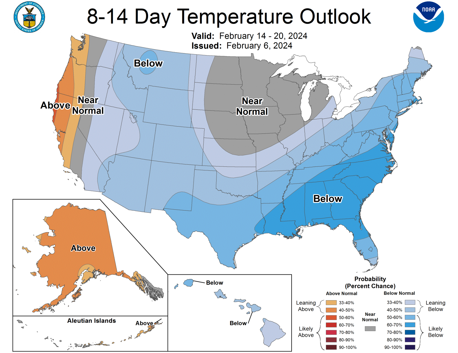
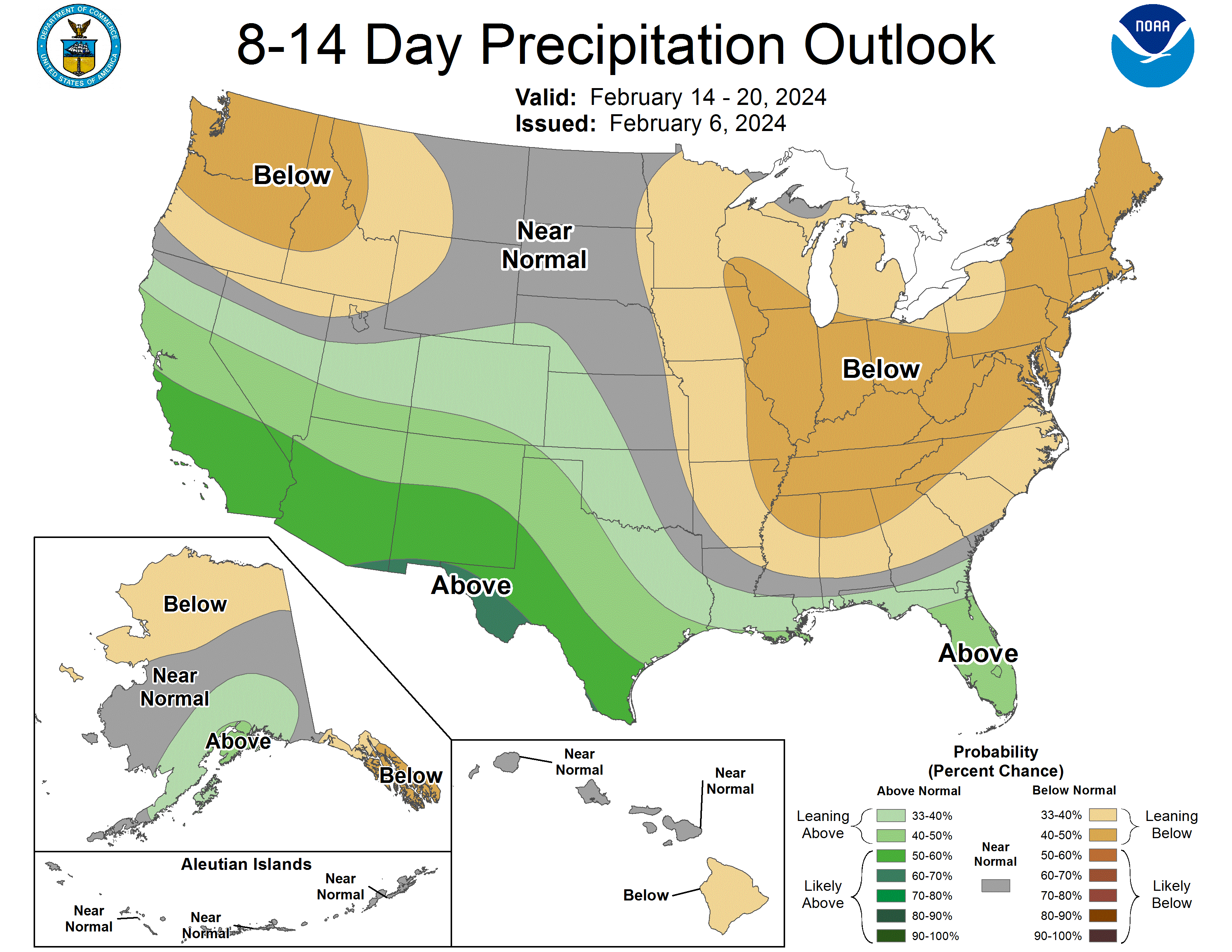
So the CPC is now on board for the pattern change to colder than normal, at least for 2/14-2/20 (and their 2/3 week forecast is also for below normal temps), as per the first graphic below, but they're also calling for drier than normal conditions for that period, so that part of the 2nd half of Feb being potentially colder/snowier than normal could well just be colder than normal, but mostly dry. It's hard to get snowstorms in our area, especially for 95 and the coast - always has been and always will be. Take today's models: all three of the 12Z globals showed storms, but all missed our area - but the 18Z GFS, which just came out has a snowstorm for most of us. We're going to see a lot of back and forth on this one, I'm sure. And @e5fdny - don't worry, a thread will be started by someone inside 5 days, should there still be at least a moderate threat.
Finally, it's very interesting to see a number of pro mets discussing the similarities of this forecasted pattern to Feb 2010, one of the snowiest patterns we've ever seen from DC to Boston, including Philly/NJ/NYC. Again, no guarantees that this pattern will deliver snow anywhere near that (or even above normal as I've been predicting), but this is why there is heightened anticipation/concern for the upcoming pattern we're likely to see.
https://www.americanwx.com/bb/topic...ge-discussion/?do=findComment&comment=7194653
I
Or just don’t post them to begin with? 🤷♂️Reread the title and first post. The first part of it is all about the generally warm, snowless weather through about 2/12 or so, so it's not like I'm ignoring it. And the next part about the coming pattern shift to probable cold/snowy weather isn't a buzzkill for me and I'm sure others. If it's a buzzkill for you, maybe skip the thread.
Still 6+ days out, but tonight's 0Z Euro/UK/GFS/CMC all show at least moderate snowfall (and some show significant snowfall along with a fair amount of rain before the snow, so this looks fairly complex) for NYC Metro with less to the S/SW. Of course, if this continues to look wintry we'll eventually be debating about how much rain/mix before the snow and ratios and melting and everything else, but the take home message is we actually have a shot at some snow next Monday night into Tuesday. Still could be a whiff or mostly rain, especially for 95/coast, but definitely worth watching this one.
You might as well have started a thread 4 days ago because it sure as hell looks like a new weather thread with updates twice a day.
Whats amazing is he is bragging about a 2 -5 degree colder period while ignoring we have a plus 10 period coming up later in the week that may approach plus 20 for highs on Saturday with highs 60-65
Any normal person excited about weather would be touting that not a fantasy 21-28 day away snowstorm
For the last 6-7 years the rough pattern near highlands has been cold period late Nov, - early Dec. followed by mild weather Christmas to mid Feb. Then the snow comes end of Feb to early March. Winter has been back-loaded for awhile. I was was comfortably changing car oil Jan-Feb the past few years.
Last year I shoveled snow once. Five years ago we had some sub-zero weather (Feb) but just for a few days. We also had brutal March storm that wrecked electric for a month. It's the cusp weather between seasons that I dread the most. In hilly terrain, ice and snow are a bad combo with trees and boulders. Con Ed has trouble finding spare parts after the trees come down on the poles and homes. Worst winters I remember were 2010-13.
I'll stick with don't read them if you don't like them or think they're useless, especially given the very high percentage of silly/useless threads on this board. You'll get an event thread soon if we keep seeing model outcomes like last night's, i.e., maybe after tonight's late night 0Z runs, which put us about 5 days before the start of the event.Or just don’t post them to begin with? 🤷♂️
Just not a fan of your pushing of a trend thread for weather. And to be honest I don’t think many others are either. I’ll bet many really thought this was about a particular event.I'll stick with don't read them if you don't like them or think they're useless, especially given the very high percentage of silly/useless threads on this board. You'll get an event thread soon if we keep seeing model outcomes like last night's, i.e., maybe after tonight's late night 0Z runs, which put us about 5 days before the start of the event.
The event ones are needed and important. This kind of stuff (off season or not) is really better suited for your mets community pals.
Again, just my $.02 on the matter.
Why a new thread for an event you have been talking about since Feb 1
Shouldnt it just be in this thread
Shocking...colder and a snow chance in February...but maybe just cold and maybe just rain oh
Shouldnt it just be in this thread
Shocking...colder and a snow chance in February...but maybe just cold and maybe just rain oh
Last edited:
All I can say is the days are longer now, we have more warm weather (for February) before the rumored pattern shift and only seven days until pitchers and catchers report.
Again, just my $.02 on the matter.
I hope you don't mind, but in the middle of March I plan to post a thread about how, given the patterns of the last few years, the subsequent month will be experiencing a warming trend.
You might become legendary. Since Plum hasn't been good in the prediction biz of late someone should take over the crown!I hope you don't mind, but in the middle of March I plan to post a thread about how, given the patterns of the last few years, the subsequent month will be experiencing a warming trend.
Enjoy Warmth While It Lasts. Meteorologist Warns Of Winter's Return Next Week | ZeroHedge
ZeroHedge - On a long enough timeline, the survival rate for everyone drops to zero
 www.zerohedge.com
No issue with you or many others not being a fan of trend threads, but clearly some like them, so I'll continue to do them once in awhile (I've averaged slightly more than 1 per season, so it's not like I'm polluting the board with a dozen pattern threads each winter). Also, it should be crystal clear by the title that this is not an event thread - not sure how much clearer I could make it - but I often discuss longer term threats in a pattern thread, but not in great detail, like in the event threads, as there's just way too much uncertainty this far out (like the 12Z GFS now showing all rain except N of 80/84 vs. snow for most 6 hours ago).Just not a fan of your pushing of a trend thread for weather. And to be honest I don’t think many others are either. I’ll bet many really thought this was about a particular event.
The event ones are needed and important. This kind of stuff (off season or not) is really better suited for your mets community pals.
Again, just my $.02 on the matter.
I know, but people see “weather & numbers” and they assume.No issue with you or many others not being a fan of trend threads, but clearly some like them, so I'll continue to do them once in awhile (I've averaged slightly more than 1 per season, so it's not like I'm polluting the board with a dozen pattern threads each winter). Also, it should be crystal clear by the title that this is not an event thread - not sure how much clearer I could make it - but I often discuss longer term threats in a pattern thread, but not in great detail, like in the event threads, as there's just way too much uncertainty this far out (like the 12Z GFS now showing all rain except N of 80/84 vs. snow for most 6 hours ago).
* Isn’t one though truly enough? (pulling hair out emoji guy - lol)
I had recently proposed one general winter/pattern thread to cover the few to several major pattern shifts that occur in a winter and event threads within 3-5 days as needed, but you didn't seem to like that (or maybe you just didn't want any longer range threads). Are you now proposing one overall winter thread for everything? I had proposed that years ago and you and many others mutinied, lol.I know, but people see “weather & numbers” and they assume.
* Isn’t one though truly enough? (pulling hair out emoji guy - lol)
And today's 12Z models are why I didn't start a thread or start touting a snowstorm (like you can see out on social media from some), as every one of them was a rain event for 95 and the coast with a bit of snow N of 80 (and NW of 287) on some or only N of 84 on others, with only N of 84 seeing significant snow on any of the models. Just like last night's runs didn't mean we're going to get a snowstorm, today's 12Z runs don't mean the threat is dead for our region, but it certainly makes it a lot less likely. But we're still 5+ days out, so let's see how this progresses.Still 6+ days out, but tonight's 0Z Euro/UK/GFS/CMC all show at least moderate snowfall (and some show significant snowfall along with a fair amount of rain before the snow, so this looks fairly complex) for NYC Metro with less to the S/SW. Of course, if this continues to look wintry we'll eventually be debating about how much rain/mix before the snow and ratios and melting and everything else, but the take home message is we actually have a shot at some snow next Monday night into Tuesday. Still could be a whiff or mostly rain, especially for 95/coast, but definitely worth watching this one.
Also, just so folks don't think I only will post "snowy" longer range ideas for the pattern, here's a twitter thread from Tomer Burg a young met student getting his PhD, who is developing a pretty reputation as a level-headed forecaster. He's fully on board with the coming colder pattern, but he has thoughts that any snowfall we get out of it in mid/late Feb into early March will be focused SE of our area, due to suppression/confluence (too much cold air), which can happen. As always, we'll see, since many other well-respected mets (those I've quoted in earlier posts in the thread) still think our area has a good chance of seeing at least some moderate snowfalls in the coming weeks.
Similar threads
- Replies
- 412
- Views
- 23K
- Replies
- 44
- Views
- 3K
- Replies
- 59
- Views
- 3K
ADVERTISEMENT
ADVERTISEMENT