That's flat out wrong and you know it. Show me one thing I said that was wrong above. My descriptions of the models was pretty clear - I could post them to prove it, but they're not worth posting yet. And my discussion of the uncertainties is very similar to what walt drag and other top mets, such as brooklynwx, are saying. In fact, he just wrote up a fantastic summary of the synoptic setup highlighting the things that might still go wrong, but showing that some accumulating snow for even 95/coast is possible.
https://www.americanwx.com/bb/topic/59981-february-2024/?do=findComment&comment=7200829
Also, the NWS-Mt. Holly is much more optimistic than this morning, when they were only calling for a chance of snow well NW of 95; here's their latest...see the part in bold - they're acknowledging that a plowable snow is possible all the way down to 95 (the fall line). And by the way, the 18Z GFS is again showing a significant to major snowstorm for much of the area. It's still somewhat of an outlier, but much less of one than before.
LONG TERM /SUNDAY NIGHT THROUGH THURSDAY/...
Unsettled weather on tap for the start of the new work week as
a developing storm system impacts the Northeast and Mid-
Atlantic. However, there are
numerous inconsistencies among the
models that leads to a low confidence forecast.
A deep upper
trough over the West Coast ejects into the
southern Plains, and the base of the
trough pinches off into a
closed upper low over the Southern Plains and Gulf Coast states
Sunday night. Surface low pressure develops out ahead of it and
moves towards the Mid-Atlantic on Monday.
This is where the models go awry. The 12Z/08
ECMWF has the low
passing through southern New Jersey and Delmarva Monday night,
and then the low intensifies off the New Jersey coast as the
H5
trough follows behind it Tuesday morning. This system then
departs Tuesday afternoon. In terms of sensible weather, the
predominant ptype will be rain on Monday, changing to snow over
the southern Poconos and northern New Jersey Monday night and
Tuesday as colder air filters into the region behind the
departing low.
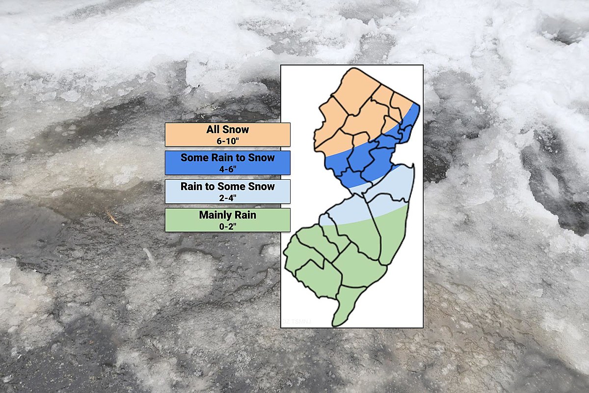
A plowable snow is possible for those areas, and
possibly even down to the Fall Line.
The surface low is faster in the 12Z/08 CMC, with rain moving
into the region earlier on Monday, and has the low over eastern
Long Island by Tuesday morning. The storm is then gone Tuesday
afternoon before the cold air filters into the region. This
results in minimal snow accumulation.
The outlier, though it has been a consistent outlier, is the
12Z/08
GFS. The storm is much slower, with the low still over
North Carolina and Virginia Tuesday morning, and then passes
through Delmarva during the day Tuesday before departing Tuesday
night. With high pressure building in from the north, cold air
advection will be underway, and temperatures drop to below
freezing across much of the region. This results in at least a
plowable snow across much of southern New Jersey and into
Delmarva.
The NBM snow probabilities have a less than 10 percent chance
for 4 inches of snow or more in 24 hours ending at 00Z Wednesday
for most areas south of the
Fall Line, and up to 25 percent
chance for 4 inches of snow or more in the 24 hours ending at
00Z Wednesday for the southern Poconos and northern New Jersey.
Due to the low confidence in the forecast, opted to follow the
NBM guidance closely. This results in
likely PoPs for Monday
afternoon and Monday night, and chance
PoPs for Tuesday morning.
Opted to keep
slight chance PoPs continuing into Tuesday
afternoon, mainly due to the
GFS being slower.