All of these cities have only seen a trace of snow (snow falling but not accumulating at least 0.1") so far this winter and given how unlucky the NE has been this winter (especially not getting any snow in a December pattern that was ripe for snow), who knows, maybe some of these cities could be looking at a goose egg and even if not, way below normal snowfall is very very likely now (but not a given, knowing that 20" snowfalls can happen in a single storm, which is a season's worth for some of these cities). Even Boston has barely had snow so far this season.
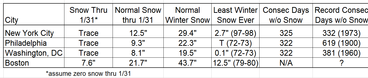
Below are some data for this winter in selected NE cities. Add in Baltimore, Wilmington, AC, NB, Richmond, and more to the list of NE cities that have been snowless so far this winter. FYI, Newark, LGA and JFK all eked out 0.1" back in December, so they're not technically snowless, but might as well be. And basically everywhere else in the NE US is well below normal for snowfall, to date, except Buffalo and Watertown, due to the insane lake effect snows both have seen - the 2nd table is through 1/15/23, but little snow has fallen since then for most locations in the table.
In case anyone is wondering, December 2022 was just about average, temperature-wise for Philly-NJ-NY (slightly below normal for some), but January is shaping up to be the 1st or 2nd warmest January on record for most, with NYC likely being 9.0F above normal (2nd warmest ever) and Philly being close to 10F above normal, both of which are just crazy warm. In addition, NYC just had its 32nd straight warmer-than-normal day, breaking its all-time record (records in NYC go back to 1869) with a few more warm days to come; in addition, this will be the first winter in NYC history with zero snow through the end of January. So yeah, it's been warm.
So, where are we headed? Well next week there's a modest shot at getting a minor snowfall for much of the area sometime between Tuesday night and Thursday, with several shortwaves passing through along a frontal boundary, which will give us normal to a bit below normal temps for this period, so it will be cold enough to snow, but the uncertainty on that is quite high, as some models are showing any precip suppressed to our south and there's also indication that the "storms" will become sheared out messes delivering very little precip to anyone. Still too early to be sure.
Beyond that, there are strong indications that we'll finally see some seriously cold air by next weekend, which should stick around for at least a few days, but as we saw in December, cold air isn't enough to give us snow (but it's a start). I don't typically make any long-term predictions, but simply given climatology/past history, it's highly likely we at least get some measuable snow this winter, but we'll have to wait to see that. All I can say is it better not snow when I'm in FL visiting family in early Feb (and 2/6 is one date in the future we need to keep an eye on for snow/rain), lol.
https://www.accuweather.com/en/wint...n-stuck-in-a-snow-drought-this-winter/1469959
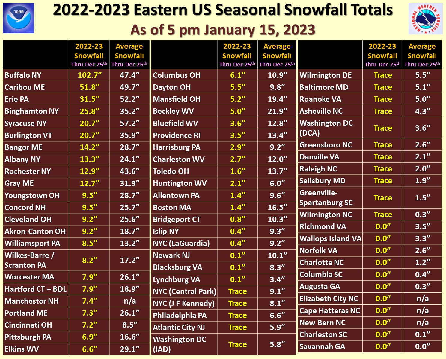