
I through out all my clothes after that Temple game even having rain gear. Heavy rain good winds, miserable game.Nowhere near enough rain in the forecast for a poncho, IMO, although I'm not the guy to listen to on that one, lol, as I have no issue getting wet, unless it's pretty cold (I think Temple in 2002 and Army in 2007 were the only games I wore rain gear for) and it won't be cold on Saturday.
Colleges
- American Athletic
- Atlantic Coast
- Big 12
- Big East
- Big Ten
- Colonial
- Conference USA
- Independents (FBS)
- Junior College
- Mountain West
- Northeast
- Pac-12
- Patriot League
- Pioneer League
- Southeastern
- Sun Belt
- Army
- Charlotte
- East Carolina
- Florida Atlantic
- Memphis
- Navy
- North Texas
- Rice
- South Florida
- Temple
- Tulane
- Tulsa
- UAB
- UTSA
- Boston College
- California
- Clemson
- Duke
- Florida State
- Georgia Tech
- Louisville
- Miami (FL)
- North Carolina
- North Carolina State
- Pittsburgh
- Southern Methodist
- Stanford
- Syracuse
- Virginia
- Virginia Tech
- Wake Forest
- Arizona
- Arizona State
- Baylor
- Brigham Young
- Cincinnati
- Colorado
- Houston
- Iowa State
- Kansas
- Kansas State
- Oklahoma State
- TCU
- Texas Tech
- UCF
- Utah
- West Virginia
- Illinois
- Indiana
- Iowa
- Maryland
- Michigan
- Michigan State
- Minnesota
- Nebraska
- Northwestern
- Ohio State
- Oregon
- Penn State
- Purdue
- Rutgers
- UCLA
- USC
- Washington
- Wisconsin
High Schools
- Illinois HS Sports
- Indiana HS Sports
- Iowa HS Sports
- Kansas HS Sports
- Michigan HS Sports
- Minnesota HS Sports
- Missouri HS Sports
- Nebraska HS Sports
- Oklahoma HS Sports
- Texas HS Hoops
- Texas HS Sports
- Wisconsin HS Sports
- Cincinnati HS Sports
- Delaware
- Maryland HS Sports
- New Jersey HS Hoops
- New Jersey HS Sports
- NYC HS Hoops
- Ohio HS Sports
- Pennsylvania HS Sports
- Virginia HS Sports
- West Virginia HS Sports
ADVERTISEMENT
You are using an out of date browser. It may not display this or other websites correctly.
You should upgrade or use an alternative browser.
You should upgrade or use an alternative browser.
Weather for MSU @ RU: seasonable temps/likely dry (maybe a light shower or two)
- Thread starter RU848789
- Start date
I was referring to the wind being no good . Thanks for the offer .Wear ponchos .. I have a few Red if you want one.

I have sandbags for the tents if you need them…. Paper plates your on your own…. lolI was referring to the wind being no good . Thanks for the offer .
And still no real change in the forecast. It's going to be mild (temps in the low 60s in the morning with a high in the upper 60s), cloudy and a bit breezy (10-15 mph winds), with mostly dry conditions, although some spotty drizzle/sprinkles are possible, especially after about noon.No real change in the forecast, as the backdoor cold front will be ushering in low clouds Friday night into Saturday on ENE winds and the approaching trough from the west and the low off the SE coast will be trying to feed moisture into the area, but the models continue to hold this moisture off, for the most part until Saturday evening, with only some sprinkles/drizzle possible, especially after about 1-2 pm.
About half of the models show zero precip from sunrise through late afternoon on Saturday, while a couple show up to about 0.02" of light rain during that time. Certainly nuisance precip, IMO, but some will not like it. It'll certainly be cloudy and mild with high temps around 70F and a bit breezy with 10-15 mph winds. The official NWS-Philly precip forecast is for about a 20% hance of some sprinkles/drizzle, amounting to about 0.01" of rain during the daytime hours, whereas the NWS-NYC precip forecast for Union/Staten Island, just to our north and east, respectively, is for completely dry weather through daytime. Football weather.
https://forecast.weather.gov/MapClick.php?lon=-74.46300599110211&lat=40.52455975850225#.YV9ah9rMJ3j
However, keep in mind that about half of the models show no rain at all through about 2-3 pm (NAM, UK, and HRRR), a couple show up to 0.01-0.02" of rain (GFS/CMC) and the Euro is showing up to 0.05" of rain, while the NWS is showing a forecast of about 0.01" of total precip (a model blend) during the day on Saturday, so this is very far from a washout and I would call this nuisance level precip. I hope the clouds and some spotty sprinkles don't keep too many people away - would be nice to have a big crowd to help us beat MSU.
For the shore folks, there is a coastal flood advisory for minor tidal flooding at times of high tide...
https://www.weather.gov/phi/
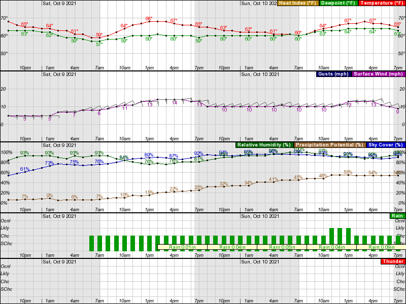
I like the latest update from the NWS, below. Looking like we won't see anything more than a few light sprinkles through the afternoon. Enjoy the game.
National Weather Service Mount Holly NJ
630 AM EDT Sat Oct 9 2021
NEAR TERM /THROUGH TONIGHT/...
6:30 Update...
The backdoor front has cleared most of the region. While cloud cover
has increased, it is not a solid overcast, and it seems increasingly
probable there will be at least a bit of sunshine in many areas
today. There have also been a few light showers/sprinkles in some
spots, but these should remain quite limited in coverage through the
day. Outside of lowering sky cover a bit, no major changes have been
made with this update.
Took 24 hours off from RU football after yesterday's debacle (plus I had an all day disc golf tourney today), so just getting around to this now. Anyway, at this point the forecast looks somewhat like we had 6-7 days out last week, i.e., high pressure entrenched from mid-week onward and an upper level cutoff low trying to move its way towards us from our west with a trough late in the week. This past week, the high pressure held strong and we had gorgeous weather for this weekend, while the models currently show a range of solutions, from something similar to this weekend to the high eroding and occasional drizzle/showers being possible on gameday. Temps are forecast to be seasonable (avg high/low on 10/9 is 68/45) at this point, so if the rain holds off it could be a nice day. Still too far out to know which way this one will go.
https://forecast.weather.gov/produc...&format=CI&version=1&glossary=1&highlight=off
Area Forecast Discussion
National Weather Service Mount Holly NJ
337 PM EDT Sun Oct 3 2021
LONG TERM /WEDNESDAY THROUGH SUNDAY/...
The cutoff low will continue to spin to our southwest through the
greater part of the week, slowly absorbing back into the parent
westerly flow by Friday as a kicker shortwave ejects from the
Rockies over the northern Plains. Instead, the remnant energy from
the trough erodes as a piece of vorticity lifts with the Plains
trough and the remaining vorticity drifts off the Southeast Coast.
Rather impressive mid-level ridging for this time of year builds
ahead of the developing amplified trough over the West. This shoots
500 mb heights over 576 dm well towards the Hudson Bay. While we
stay damp and on the humid side, this keeps us slightly warmer than
average for this time of year with highs in the low to mid 70s
Wednesday through Sunday with lows in upper 50s to low 60s.
As for precip chances, this is a more difficult call as the entire
period remains rather unsettled. With onshore flow in the wake of
Tuesday`s front, added the mention for drizzle Wednesday with the
stronger onshore flow from east to west. Thursday looks to be
perhaps the best day with the lowest chances for drizzle and rain
showers. Am more inclined to call them periods of light rain but
left forecast wording as showers for now as the latest guidance has
trended downward on PoPs it appears. Depending on how the cutoff low
erodes by Friday will determine the rain chances; if it absorbs
into the new trough further to our west, we`ll remain on the
drier side. I am more in favor of this solution given the trend
with the past cut-off low of last week continually improving.
Global guidance seems to be absorbing this low a little more
quickly each run the past few days with the surface high inching
further southeast into our region.
Did you use those discs that I gave u in the disc golf tournament? Did you win? LMK
Sun's out in Metuchen! Should be some breaks in the clouds for at least the tailgates and no precip on the radar (and none likely before the game, as per all of the short-term, mesoscale models). About to head over to yellow to enjoy the day...Thanks for the Update.
Perfect football weather. We should have 45,000 in the house today. “Get into the Stadium early”
Game sucked, but at least the weather held up for the tailgates and we only had a 2-minute sprinkle during the game. Models did well, as did the NWS with their forecast the past several days.Sun's out in Metuchen! Should be some breaks in the clouds for at least the tailgates and no precip on the radar (and none likely before the game, as per all of the short-term, mesoscale models). About to head over to yellow to enjoy the day...
Disc golf lolTook 24 hours off from RU football after yesterday's debacle (plus I had an all day disc golf tourney today), so just getting around to this now. Anyway, at this point the forecast looks somewhat like we had 6-7 days out last week, i.e., high pressure entrenched from mid-week onward and an upper level cutoff low trying to move its way towards us from our west with a trough late in the week. This past week, the high pressure held strong and we had gorgeous weather for this weekend, while the models currently show a range of solutions, from something similar to this weekend to the high eroding and occasional drizzle/showers being possible on gameday. Temps are forecast to be seasonable (avg high/low on 10/9 is 68/45) at this point, so if the rain holds off it could be a nice day. Still too far out to know which way this one will go.
https://forecast.weather.gov/produc...&format=CI&version=1&glossary=1&highlight=off
Area Forecast Discussion
National Weather Service Mount Holly NJ
337 PM EDT Sun Oct 3 2021
LONG TERM /WEDNESDAY THROUGH SUNDAY/...
The cutoff low will continue to spin to our southwest through the
greater part of the week, slowly absorbing back into the parent
westerly flow by Friday as a kicker shortwave ejects from the
Rockies over the northern Plains. Instead, the remnant energy from
the trough erodes as a piece of vorticity lifts with the Plains
trough and the remaining vorticity drifts off the Southeast Coast.
Rather impressive mid-level ridging for this time of year builds
ahead of the developing amplified trough over the West. This shoots
500 mb heights over 576 dm well towards the Hudson Bay. While we
stay damp and on the humid side, this keeps us slightly warmer than
average for this time of year with highs in the low to mid 70s
Wednesday through Sunday with lows in upper 50s to low 60s.
As for precip chances, this is a more difficult call as the entire
period remains rather unsettled. With onshore flow in the wake of
Tuesday`s front, added the mention for drizzle Wednesday with the
stronger onshore flow from east to west. Thursday looks to be
perhaps the best day with the lowest chances for drizzle and rain
showers. Am more inclined to call them periods of light rain but
left forecast wording as showers for now as the latest guidance has
trended downward on PoPs it appears. Depending on how the cutoff low
erodes by Friday will determine the rain chances; if it absorbs
into the new trough further to our west, we`ll remain on the
drier side. I am more in favor of this solution given the trend
with the past cut-off low of last week continually improving.
Global guidance seems to be absorbing this low a little more
quickly each run the past few days with the surface high inching
further southeast into our region.
Yes the Models were spot on.Game sucked, but at least the weather held up for the tailgates and we only had a 2-minute sprinkle during the game. Models did well, as did the NWS with their forecast the past several days.
Absolutely perfect football conditions.
Finished 2nd; had a 3-stroke lead after one round, but played badly in the 2nd round - shit happens. Won $100, which is nice, but secondary to having a fun day playing disc golf. Didn't use the discs, because I've been throwing even my 50-mold less - the big discs are very cool, but just don't stay in the basket as well as the small ones.Did you use those discs that I gave u in the disc golf tournament? Did you win? LMK
The whole way down my wife was saying "look at all those clouds it's going to pour" I simply told her that Numbers has it covered so relax
Thanks, but that's a lot of pressure, lol.
Yes the Models were spot on.
Absolutely perfect football conditions.
Was my favorite weather of the year for a tailgate/game, so far, as I don't love the sun (I burn easily and it can be too hot). Problem is getting a cloudy day without rain is threading the needle, which we were lucky enough to do this past Saturday.
Just one more sport I'm better than you at.
What are the other one's lol? And the fact you think "disc" golf is a sport tells me all I need to know.
Can't mooch off your buddies anymore to get on a real golf course so you took up disc. Got it.
Actually, I now have several more friends who belong to country clubs (people have more $$ later in their careers), and they're all pushing me to get back into ball golf, so since I'm retired, will likely do that this spring. Might even join a club if it makes sense (it might as golf has become so crowded in NJ). I see no reason I can't get back to a 7/8 handicap or close to it if I play regularly again, which was better than what you were last time this was discussed. So that would make at least 2 sports, as DG is certainly a sport - happens to be the fastest growing sport in the US - you should try it, it's a lot of fun.What are the other one's lol? And the fact you think "disc" golf is a sport tells me all I need to know.
Can't mooch off your buddies anymore to get on a real golf course so you took up disc. Got it.
Actually, I now have several more friends who belong to country clubs (people have more $$ later in their careers), and they're all pushing me to get back into ball golf, so since I'm retired, will likely do that this spring. Might even join a club if it makes sense (it might as golf has become so crowded in NJ). I see no reason I can't get back to a 7/8 handicap or close to it if I play regularly again, which was better than what you were last time this was discussed. So that would make at least 2 sports, as DG is certainly a sport - happens to be the fastest growing sport in the US - you should try it, it's a lot of fun.
I'm an athlete. Disc golf seems akin to bumper pool or something. It ain't a sport.
So, you are still mooching off your friends, and my index is much lower than yours. So you aren't better in any sport. That's without getting into things I didn't just got into four years ago. In four years from starting to play I got down to a 9.
Good luck into a real club. You won't be able to wear those jorts and all that other stuff you've been talking about. Have you thought about needing to dress appropriately as a member of a club? They aren't for everyone.
Well, neither disc golf nor ball golf are that much of a sport, compared to sports that involve much more athleticism, like football, socceer, hoops, etc., but disc golf is a bit more physically demanding than ball golf, since it's a long walk through the woods, usually, often up and down rugged terrain and there aren't any carts.I'm an athlete. Disc golf seems akin to bumper pool or something. It ain't a sport.
So, you are still mooching off your friends, and my index is much lower than yours. So you aren't better in any sport. That's without getting into things I didn't just got into four years ago. In four years from starting to play I got down to a 9.
Good luck into a real club. You won't be able to wear those jorts and all that other stuff you've been talking about. Have you thought about needing to dress appropriately as a member of a club? They aren't for everyone.
So you're a 9 in 4 years. That's decent. I went from never playing ball golf to a 7/8 in 2 years in my early 20s, so I'd say the golf is likely a wash, since I'll give you some credit for doing it a bit later in life even if it took you longer to almost reach the level I did when I was much younger.
I know you played lacrosse at RU, which is impressive. I played football and baseball in HS my first two years and then broke a foot and an ankle junior year in the fall and the spring, respectively, so didn't play sports my junior year and focused on partying my senior year. Played ultimate frisbee for Rutgers my first two years and then got into disc golf and then ball golf in grad school. Played a lot of intramural hoops at RU also (had a 36" vertical back then). Been playing mostly keeper in soccer for the past 10 years and got pretty good at it for someone who didin't play soccer as a kid; have also been playing softball for the past 15 years. I also have a pool table in the living room and am pretty good at that "sport." None of those are the equal of playing Division 1 lacrosse, but I still consider myself a pretty good athlete, even at almost 60.
You also look a bit silly with your country club comments. Played a lot of clubs in the past, so it should be obvious I know what the expectations are around a private club, which is why my buddies want me to start playing golf again now. Getting into a "real club" isn't that hard when you know people in "real clubs." The only issue will be whether I redevelop the passion for the game enough to join - the $$ is a non-issue - you don't think I retired at 57 without plenty of $$ do you?
Well, neither disc golf nor ball golf are that much of a sport, compared to sports that involve much more athleticism, like football, socceer, hoops, etc., but disc golf is a bit more physically demanding than ball golf, since it's a long walk through the woods, usually, often up and down rugged terrain and there aren't any carts.
So you're a 9 in 4 years. That's decent. I went from never playing ball golf to a 7/8 in 2 years in my early 20s, so I'd say the golf is likely a wash, since I'll give you some credit for doing it a bit later in life even if it took you longer to almost reach the level I did when I was much younger.
I know you played lacrosse at RU, which is impressive. I played football and baseball in HS my first two years and then broke a foot and an ankle junior year in the fall and the spring, respectively, so didn't play sports my junior year and focused on partying my senior year. Played ultimate frisbee for Rutgers my first two years and then got into disc golf and then ball golf in grad school. Played a lot of intramural hoops at RU also (had a 36" vertical back then). Been playing mostly keeper in soccer for the past 10 years and got pretty good at it for someone who didin't play soccer as a kid; have also been playing softball for the past 15 years. I also have a pool table in the living room and am pretty good at that "sport." None of those are the equal of playing Division 1 lacrosse, but I still consider myself a pretty good athlete, even at almost 60.
You also look a bit silly with your country club comments. Played a lot of clubs in the past, so it should be obvious I know what the expectations are around a private club, which is why my buddies want me to start playing golf again now. Getting into a "real club" isn't that hard when you know people in "real clubs." The only issue will be whether I redevelop the passion for the game enough to join - the $$ is a non-issue - you don't think I retired at 57 without plenty of $$ do you?
Advice. And take this to heart. If you call it "ball golf", you will be asked to immediately leave any real club.
I am guessing what you and I consider "real money" differs. How much do you think a real club costs? How long do you think it takes typically?
Carts? Yea, you aren't playing real clubs. No real club allows carts unless you are old.
Good to know my index is lowers than yours. Anything else you want to try? We don't even have to get into lacrosse which is obviously a non starter for you.
Of course your index is lower than mine now, as I've barely played in the last 10 years. But it took you 4 years to get to 9 and it took me 2 years to get to 7/8, so I win that one.
I've played some very nice clubs in NJ, back when I played a lot and have friends in some great clubs now, so I know what they cost and cost isn't an issue within reason, i.e., I'm not joining Pine Valley at $300K (and would never be asked to obviously - nor would you), but the real question is whether I get the bug to play all the time again, like I have with disc golf, where I'm playing just about every day (used to do that with golf for many years). We'll see.
I don't believe you got to a 7 in two years.
Disc golf lol.
If you aren't prepared to spend $200k you aren't joining a real club. Not an elite one anyway.
I don't really give a shit what you believe, but I was playing 5-6 rounds a week in grad school for 9-10 months out of the year, which makes fast improvement far more possible. My old roommate and fellow grad student at the time got to about a 9 or 10 over the same timeframe and we had great battles. He'd vouch for me (he;s a huge RU fan and lurks on the board, but I don't think he posts), but what's the point? You'd say he was lying, since you can't comprehend that someone did something better than you.I don't believe you got to a 7 in two years.
Disc golf lol.
If you aren't prepared to spend $200k you aren't joining a real club. Not an elite one anyway.
Yeah, I'm not going to pay $200K to join a club, but there are tons of "real" clubs for under $50K in this area and if I get the bug again, that's doable. I'm also retired, so have no need to impress people or do business on the golf course - those things seem very important to you and if you can afford a $200K club, congrats.
I also don't really care if you have more money than I do - I have a few friends who have net worths over $50MM, but none of them brags about their wealth, like you do, and we're still as good of friends as we were when we all didn't have much money - it's all relative, as I have a lot more $$ than some of my other friends and I can't imagine trying to embarrass them about money. My guess is you only have this persona on this board, as I would think you'd have very few friends if you actually behaved in real life like you do here.
I'm enjoying retired life immensely so far: tons of disc golf, lots of poker with our crew (throughout COVID even, on-line), some projects around the house and plenty of quality time with my wife and our son and his girlfriend, who moved in with us for COVID (bonus time we never expected to have with our son) and are now looking to buy a house soon, as he got a great job several months ago after getting his Masters from RU and is saving up quickly living at home.
And I was fortunate enough to be named RU's Chem Eng'g Dept. Alum of the Year in 2020 - and I'm sure part of that was because my colleague and I, from Merck, split the cost of an endowed $50K scholarship, which will exist in perpetuity, providing a $5K scholarship annually to deserving students - and part was likely due to me recruiting dozens of eng'g students to Merck over a 12-year period and volunteering for all kinds of activities with the dept for longer than that. I don't post that to brag, but rather to try to encourage other RU alums to give back to the University in whatever way they can, as it's very rewarding. Probably worth a separate thread on this...

Similar threads
- Replies
- 41
- Views
- 2K
- Replies
- 87
- Views
- 4K
- Replies
- 131
- Views
- 5K
ADVERTISEMENT
ADVERTISEMENT