Wow. Asbury Park:
Flooding in Asbury Park: Kayakers glide over Lake Avenue
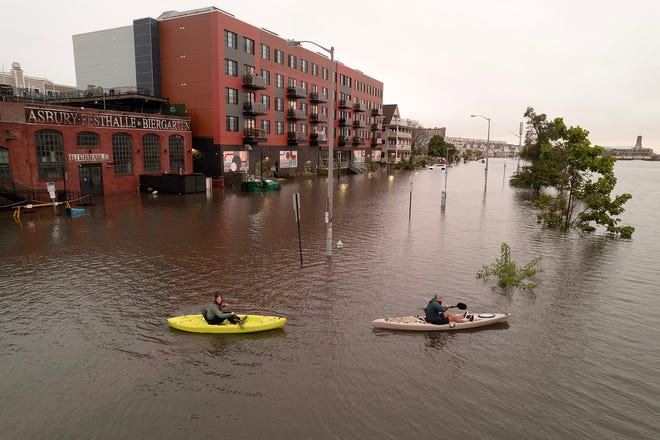
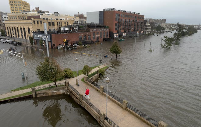
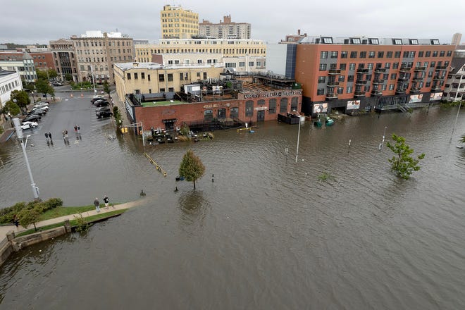
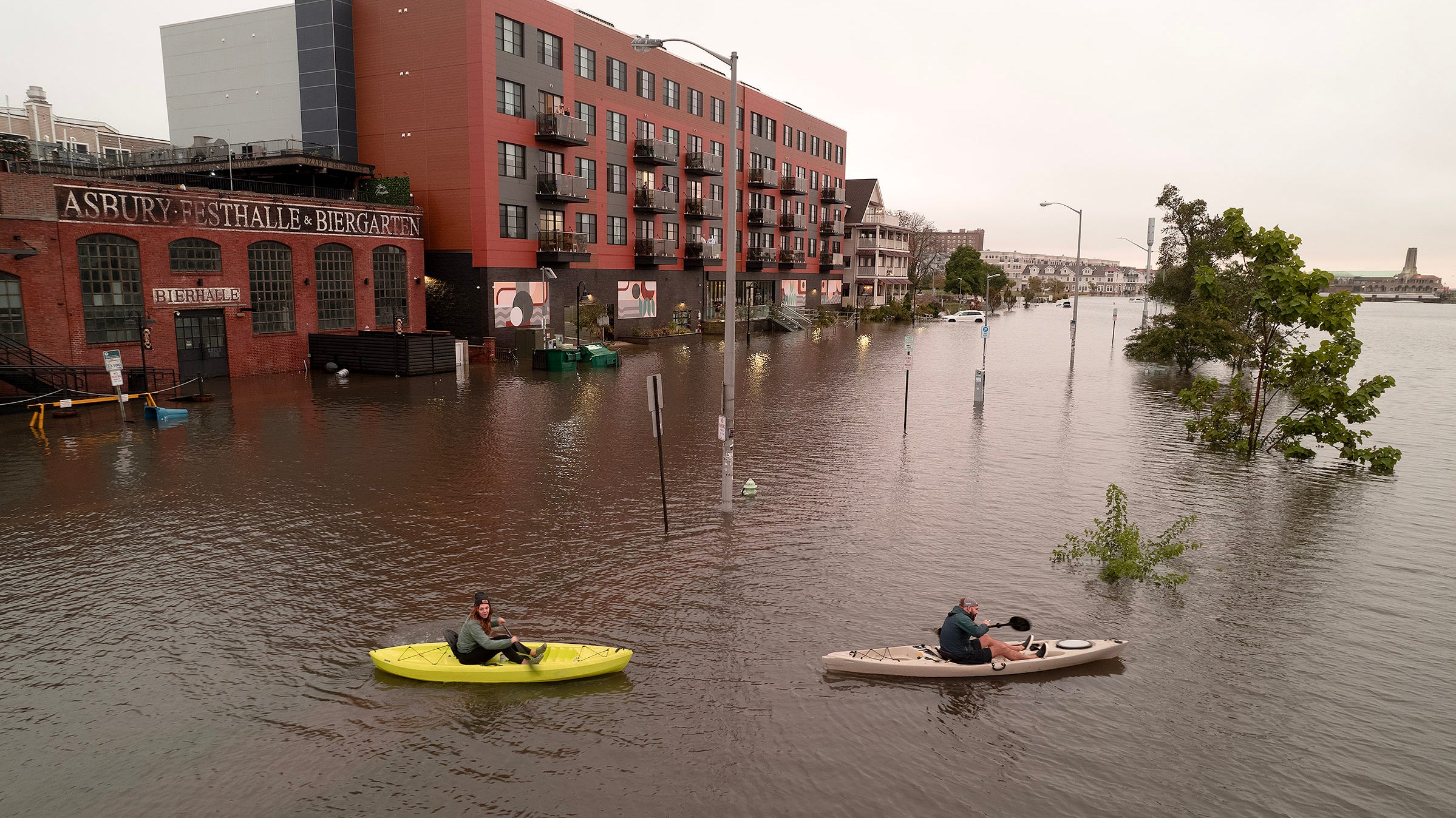
DRONE VIEW: Kayakers glide over Lake Avenue in Asbury Park after heavy rains force Wesley Lake to overflow.www.app.com
Its just a sliver of the state some say


Follow along with the video below to see how to install our site as a web app on your home screen.
Note: This feature may not be available in some browsers.
Wow. Asbury Park:
Flooding in Asbury Park: Kayakers glide over Lake Avenue
DRONE VIEW: Kayakers glide over Lake Avenue in Asbury Park after heavy rains force Wesley Lake to overflow.www.app.com
It was just a sliver of the state that got rains like that - that doesn't imply anything about the seriousness of the flooding there. What is your problem and why have you become such a whiny bitch? You're childish comments are almost as bad as your lame attempts to get me to comment on CE board threads by tagging me incessantly - surely you have better things to do than that, no?Its just a sliver of the state some say
Isn't it obvious that he doesn't ?It was just a sliver of the state that got rains like that - that doesn't imply anything about the seriousness of the flooding there. What is your problem and why have you become such a whiny bitch? You're childish comments are almost as bad as your lame attempts to get me to comment on CE board threads by tagging me incessantly - surely you have better things to do than that, no?
69 isn’t warm. It’s hot!Yes , even 69 isn’t considered “warm” by most people.
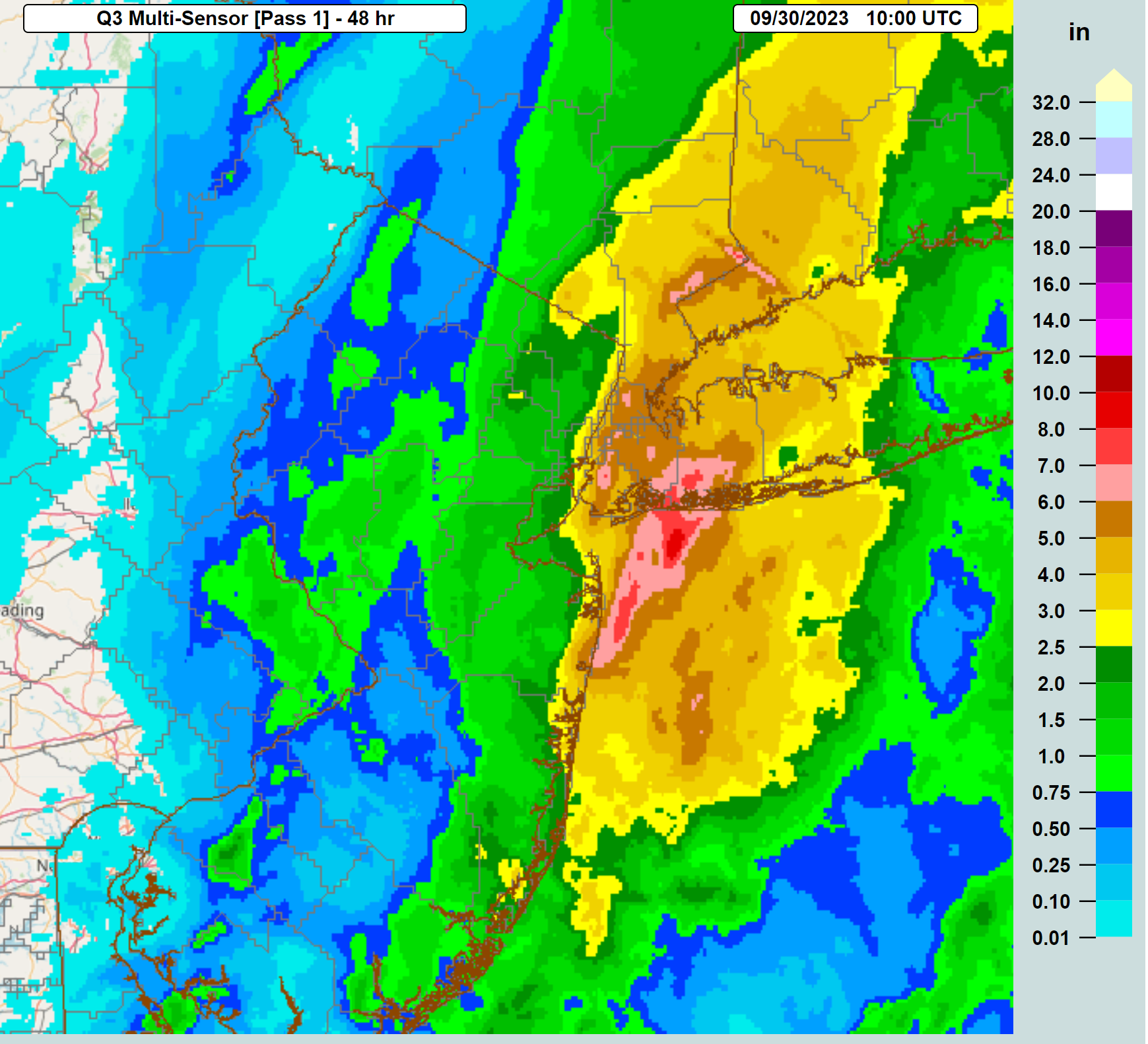
Long branch was 7.75 inchesFinal total at JFK was 8.65 inches!! 👀
May have beat that in Wall. Emptied our rain gauge at 7.5 inches last evening. There is at least another inch of rain in the gauge.Long branch was 7.75 inches
Depends on the time of year and what you are accustomed at that point69 isn’t warm. It’s hot!
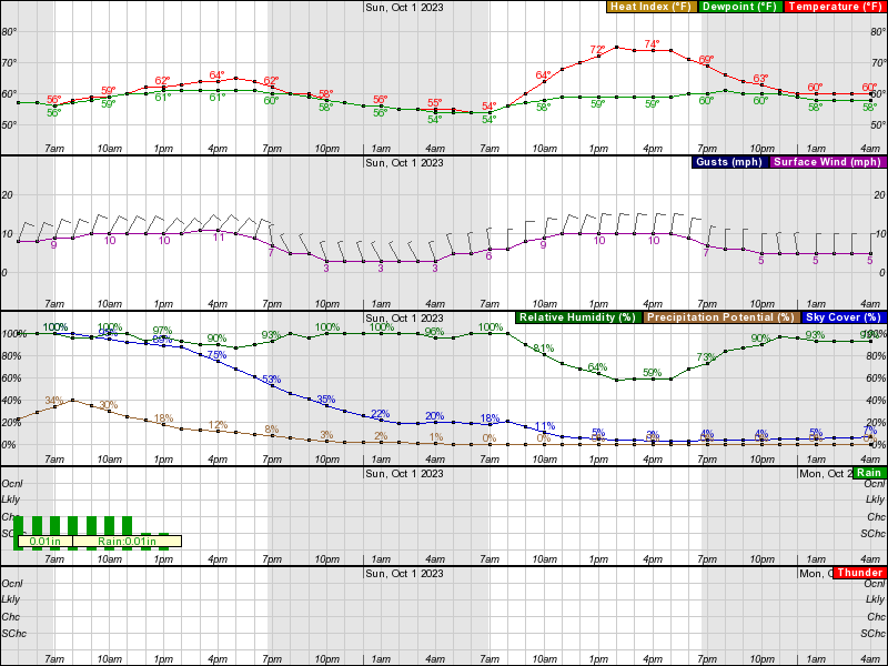
Reports in the Clifton/ Montclair area came in at about 1.5 inchesFYI, here's the "final" storm total rainfall amounts, via radar, through 6 am. Keep in mind that these sometimes won't show highly localized maxes or mins. For example, there was a report of 7.7" in Long Branch that doesn't really show up on the graphic, but the graphic does show the peak of 5-6"+ in the Asbury/Neptune/Long Branch area. It also shows the incredible 5-8" amounts across much of NYC, Nassau County and a bit of SENY/SWCT, as evidenced by reports of 5.8" in Central Park, 8.6" at JFK (the most ever there since records have been kept), and 9.0" in Valley Stream, LI. The NWS rainfall reports are linked below.
It's also worth noting that the monster rainfall amounts over 4" almost completely missed NJ, except for the immediate coast and the far eastern parts of Hudson/Bergen Counties and that for most of the rest of CNJ/NNJ, "only" 0.5-2" of rain fell, which was a bit below the 2-4" forecast.
https://www.weather.gov/wrh/TextProduct?product=pnsphi
https://forecast.weather.gov/product.php?site=okx&issuedby=OKX&product=PNS
Did you see anything good/bad regarding the,green lot, if you went by that?Let's get back to important things like tailgating. This evening around 6 pm, I decided to drive over and inspect the lots and the vast majority of yellow and blue are just damp, except near the very front, which is a low point and has some puddles (more in blue than yellow). And given we have not had much rain since 6 pm and we don't expect more than maybe another 1/4" (if that), I'm pretty sure those puddles will be gone by 8 am, given some continued slow drainage in the lots. Retired life, lol.
As I said earlier in this thread, below, I didn't think we'd have any issues in yellow/blue, given that 2 years ago, after P’way got 8”+ of rain from Ida on a Wednesday night before a Thursday night game, I went out to the lots around noon on Thursday and remarkably, they were all fairly dry except near the low points in the front – they postponed the game, anyway, because of record flooding from the Raritan River throughout NB/P’way (we’ve had no flooding today and none is expected since <1/2” of additional rain is likely).
So, hopefully the lots are in good shape and we only have a few brief showers before noon and none after that and we get to see some sunshine during the game and blow out Wagner and don't have any key injuries and then beat WI and MSU to become bowl eligible...
Anyway, the first couple rows of the blue lot are probably an absolute mess already, and with the rain I see out there right now, if that’s what we’re gonna get all night and all day tomorrow into Saturday, they should probably just put yellow tape around that front corner
@MrsScrew
Damn!Our normal spot in the Blue Lot is under water. Also, 8am...it's very windy & cold.
Our normal spot in the Blue Lot is under water. Also, 8am...it's very windy & cold.
Your investigation seems suspect baseed on Mrs Screws picture.Let's get back to important things like tailgating. This evening around 6 pm, I decided to drive over and inspect the lots and the vast majority of yellow and blue are just damp, except near the very front, which is a low point and has some puddles (more in blue than yellow). And given we have not had much rain since 6 pm and we don't expect more than maybe another 1/4" (if that), I'm pretty sure those puddles will be gone by 8 am, given some continued slow drainage in the lots. Retired life, lol.
As I said earlier in this thread, below, I didn't think we'd have any issues in yellow/blue, given that 2 years ago, after P’way got 8”+ of rain from Ida on a Wednesday night before a Thursday night game, I went out to the lots around noon on Thursday and remarkably, they were all fairly dry except near the low points in the front – they postponed the game, anyway, because of record flooding from the Raritan River throughout NB/P’way (we’ve had no flooding today and none is expected since <1/2” of additional rain is likely).
So, hopefully the lots are in good shape and we only have a few brief showers before noon and none after that and we get to see some sunshine during the game and blow out Wagner and don't have any key injuries and then beat WI and MSU to become bowl eligible...
It ain't gonna be high 60s numbers, change the title.
Need to account for wind and dampness too. Sunny, no eind, low humidity, sure 68 is warm. Today? Not warm.Eventually it could get there but the thread title is just misrepresenting and thats been my whole point. He is too stubborn and arrogant to admit a little mistake. Nobody walks outside this morning and says boy its going to be a warm one. Not a big deal but noticable on how hard he fights it
Was supposed to get a haircut one block over. Owner called me and said he had to cancel. Now I know why.Wow. Asbury Park:
Flooding in Asbury Park: Kayakers glide over Lake Avenue
DRONE VIEW: Kayakers glide over Lake Avenue in Asbury Park after heavy rains force Wesley Lake to overflow.www.app.com
68 by 4PM....he was rightIt ain't gonna be high 60s numbers, change the title.
I will check you for goosebumps at 4 pm . We will be wearing fall gear68 by 4PM....he was right
Yep, can see it on the radar. Any light showers and drizzle, should be between now and noon. Hopefully it's minimal. All of the models show any light rain/drizzle over by noon. Thought the water in the front of blue would have receded by now - sorry about that.927 a.m. It is now started to drizzle. Fun times
66 at 4pm in Piscataway according to Weather Underground68 by 4PM....he was right
I guess I'll have to stop at Scarlet Fever. I'm wearing shorts, a long sleeve T-shirt and a light windbreaker. Not all bad, haven't been to Scarlet Fever in a few years so that's a bonus!927 a.m. It is now started to drizzle. Fun times
66 at 4pm in Piscataway according to Weather Underground
No need to apologizeYep, can see it on the radar. Any light showers and drizzle, should be between now and noon. Hopefully it's minimal. All of the models show any light rain/drizzle over by noon. Thought the water in the front of blue would have receded by now - sorry about that.
Can we quantify mid 60s and high 60s like we quantify Central Jersey?66 at 4pm in Piscataway according to Weather Underground
Can we quantify mid 60s and high 60s like we quantify Central Jersey?
Mid is 64-67
High is 68-69

It says mid/upper 60s - check your prescription - and does that really matter anyway? The shower hitting Metuchen right now is heavier than expected and was not forecast by the short term models, which are usually pretty accurate inside 2-3 hours and will likely hit the lots shortly. Hopefully it exits soon.It ain't gonna be high 60s numbers, change the title.
"Weather Underground? " Did you do a google search for "coolest high temp in Piscataway, NJ today" lol! My phone app says 68 so I'll stick with it as it's usually on-point66 at 4pm in Piscataway according to Weather Underground
Thanks, although I always feel badly if I've made a prediction that ends up being wrong, like water in the front of the blue lot. That was my prediction. I generally don't feel nearly as badly when a weather forecast (that I generally don't actually make) goes awry as I'm reporting what other experts say and weather forecasting is an inherently uncertain endeavor.No need to apologize
Guys bust your chops too much over minor details
Hoping all rain/drizzle ends by 11:30, my scheduled arrival
Weather Channel has added more rain starting around noon in Piscataway.It says mid/upper 60s - check your prescription - and does that really matter anyway? The shower hitting Metuchen right now is heavier than expected and was not forecast by the short term models, which are usually pretty accurate inside 2-3 hours and will likely hit the lots shortly. Hopefully it exits soon.
Nope - I always use Weather Underground as I find it usually on point."Weather Underground? " Did you do a google search for "coolest high temp in Piscataway, NJ today" lol! My phone app says 68 so I'll stick with it as it's usually on-point
Have fun bruhTime to do some chores and then get ready to go, so likely signing off for the day, as I don't waste my time on social media once I leave for the lots. Hope the showers are over soon and especially for our 12:30 pm tailgate, lol. Let's get an easy win with no key injuries and then make our run for a bowl...
