ADVERTISEMENT

OT: Cold and Potentially Stormy (Snowy?) Pattern for 2nd half of January

If we can get everyone in this board to go out and buy a Ford Raptor we might be able to put a stop to this snow nonsense.
Don't laugh, but I've actually started considering a Raptor instead of an SUV. It's exactly the kind of vehicle that screams COMPENSATING which fits with my tendency towards excess. Also, they look cool and can tow stuff, like enclosed car trailers and sets of wheels/tires and so forth. Did I mention they look cool? Plus I could drive right over piddly little sports cars in my way and all.

However, I'm not buying anything at just this time and me possibly getting one in the summer won't help with preventing a snowy winter.

Yeah, but they're kinda slow, given all the noise and stuff.

I appreciate a good sporty pickup. Hell, I once owned a Ranger. But I also like to be able to fit in a parking space. 😉
 
  • Like
Reactions: mildone
Yeah, but they're kinda slow, given all the noise and stuff.

I appreciate a good sporty pickup. Hell, I once owned a Ranger. But I also like to be able to fit in a parking space. 😉
A raptor can be made to fit. It'll just shove the cars to either side out wider. Plus, if I hang a shotgun (unloaded, in NJ of course) in the back window, that would allow me to park across two spaces without fear of reprisals.
 
Don't laugh, but I've actually started considering a Raptor instead of an SUV. It's exactly the kind of vehicle that screams COMPENSATING which fits with my tendency towards excess. Also, they look cool and can tow stuff, like enclosed car trailers and sets of wheels/tires and so forth. Did I mention they look cool? Plus I could drive right over piddly little sports cars in my way and all.

However, I'm not buying anything at just this time and me possibly getting one in the summer won't help with preventing a snowy winter.

I will make fun of you forever if you get a Raptor ...unless you move to the Sothwest or somewhere. The epitome of a useless midlife crisis mobile for damn near everyone.

You're better than that 😉
 
In case folks are interested in getting back to the pattern, the CPC's latest 8-14 day forecast clearly shows the pattern will likely be colder and possibly wetter (usually snowier in the winter) for 8/20-26; we already know from now through 8/20 will be colder and wetter than normal but depending on the coming storm, we don't know whether that will be snow or not and it may be for some but not for others.

iyxvReD.png


pjTzeH6.png


At least get the month right...we arent in August
 
I will make fun of you forever if you get a Raptor ...unless you move to the Sothwest or somewhere. The epitome of a useless midlife crisis mobile for damn near everyone.

You're better than that 😉
As you know, I think, I am totally NOT better than exhibiting midlife-crisis, compensation-driven, totally childish automotive purchase tendencies. The problem is that I've been exhibiting those traits my whole life. 😀
 
As you know, I think, I am totally NOT better than exhibiting midlife-crisis, compensation-driven, totally childish automotive purchase tendencies. The problem is that I've been exhibiting those traits my whole life. 😀

Oh, I do know, no argument there 😁

I meant you're a more discerning vehicle buyer than the type of Jersey Jughead who would buy a Raptor.
 
Oh, I do know, no argument there 😁

I meant you're a more discerning vehicle buyer than the type of Jersey Jughead who would buy a Raptor.
That just means I'd option it carefully, if I got one. 😀
 
It is January right? Most likely cold, no?? When I first moved to Philly in the late 80s the Delaware river froze by the Ben Franklin Bride. That winter was cold. Yes we are going to be below average but not any deep freeze type weather. Why are you making such a big deal about this pattern?
Some are interested in cold and snow, some aren't - if you're not, why bother posting in the thread? Also, the pattern does have the potential for deep freeze weather, as it should be in the single digits Sunday morning and quite possibly at or below 0F in about 9-10 days, at least in the colder suburbs, plus it might not get above 32F for almost a week from about 1/20 to 1/26.
 
Well the pattern certainly delivered a big eastern snowstorm for many, from the Plains to MS/AL and all the way up the Apps and interior PA/NY/New England, but obviously not for the 95 corridor, which was a near miss, as 1" won't move the needle much, although even just 20+ miles NW did get 2-3", which is respectable for a start.

And the pattern is still loaded with potential for the next 10 days at least. First, we have a clipper type system diving down from western Canada Weds/Thurs, which some of today's 12Z models show giving us 1-2/3-4" of snow, while other show the snow basically staying to our north. That's a fairly minor event.

Then we have the big question for this weekend, where right now the Euro is a monster snowstorm for NC to ME, including our whole area, while the GFS shows two weaker systems on Sat and Mon, neither of which has much impact here, as they stay mostly to our SE. The UK is somewhat like the GFS with a miss to our SE on Saturday, while the CMC shows a moderate hit for DC to LBI, but not much NW of there, so it's close.

Dr. Knabb on TWC did a great job comparing and contrasting the GFS and Euro for the weekend storm, showing how both models show the stalled front running down the east coast from Boston to the GOM after the Thursday small storm, but how the GFS shows two troughs, one in the Great Lakes (northern stream) and one in Texas (southern stream) remain separate as they head into the east as two weaker storms, while the Euro shows them phasing into one large, powerful system that heads up the stalled boundary into the NE US and crushes us. I know some still dismiss TWC, but I think they've gotten way better the past few years with their "expert" analysis.

There are other threats for next Monday and Wednesday, but those are too far off to discuss, especially given we're going to need to see what happens through this weekend first. If we see better consensus tonight for at least a 1-2" event on early Thursday, it'll be time for a thread, IMO, and if we see at least 3 of the 4 global models showing a significant threat for Saturday by tonight or tomorrow (tomorrow is only 4 days out), then a thread would make sense for that one, as I need to stay in the good graces of @e5fdny. 😉

And also, just for @WhiteBus it's going to continue generally being colder than normal, with some very cold outbreaks Thursday/Friday (temps nearing single digits Fri am) and probably next Weds-Fri, with temps possibly being 15-20F below normal.
 
  • Like
Reactions: miket007
Thursday is less than 72 hours away. there should be a thread on it because its a potential 1-3 type event which would be the 2nd biggest event for most of the state. Perhaps I shall start
 
Thursday is less than 72 hours away. there should be a thread on it because its a potential 1-3 type event which would be the 2nd biggest event for most of the state. Perhaps I shall start
I didn't because at 12Z only the NAM was enthusiastic about more than 2" of snow for most, with the UK/GFS at maybe 1" and the Euro, CMC and RDPS all showing basically nada. Was going to wait for 0Z tonight, but it's all yours if you want to start one earlier - the 18Z GFS and NAM both now look like a 2-3" event, but the Euro/RDPS don't look like much - was hoping we'd have more consensus tonight.
 
I didn't because at 12Z only the NAM was enthusiastic about more than 2" of snow for most, with the UK/GFS at maybe 1" and the Euro, CMC and RDPS all showing basically nada. Was going to wait for 0Z tonight, but it's all yours if you want to start one earlier - the 18Z GFS and NAM both now look like a 2-3" event, but the Euro/RDPS don't look like much - was hoping we'd have more consensus tonight.

The GFS and NAM lining up isn't something to be dismissed, even if the Euro doesn't fall in line.
 
  • Like
Reactions: bac2therac
The GFS and NAM lining up isn't something to be dismissed, even if the Euro doesn't fall in line.
Agreed, but 18Z was the first time we had any alignment between those two and I usually like to see at least 2 model cycles aligned before hopping on board - and I also think it's a red flag that we're less than 3 days out and half the models show nada.
 
This event is more likely than the weekend event as currently modelled
0Z GFS and NAM both look good for 2-3" of snow; RGEM now showing an inch or so (was showing none) and CMC. That's enough to start a thread. I have spare time and will do so, but don't care if you want to.

The big one is Saturday and the GFS just took a big step towards the Euro phased snowbomb. If the Euro holds serve and we get one of the UK or CMC on board tonight, it'll be time for a thread for that too, IMO (4 days out, as this would start Friday night).


the GFS still basically doesnt give anyone but the extreme coast anything, so the euro still on its own
 
the GFS still basically doesnt give anyone but the extreme coast anything, so the euro still on its own
Yes, but it moved the precip shield almost 100 miles NW and was much closer to a phase than it was at 12Z, meaning it's now quite close to what the Euro is showing. Still many questions - let's see what the CMC/UK say.
 
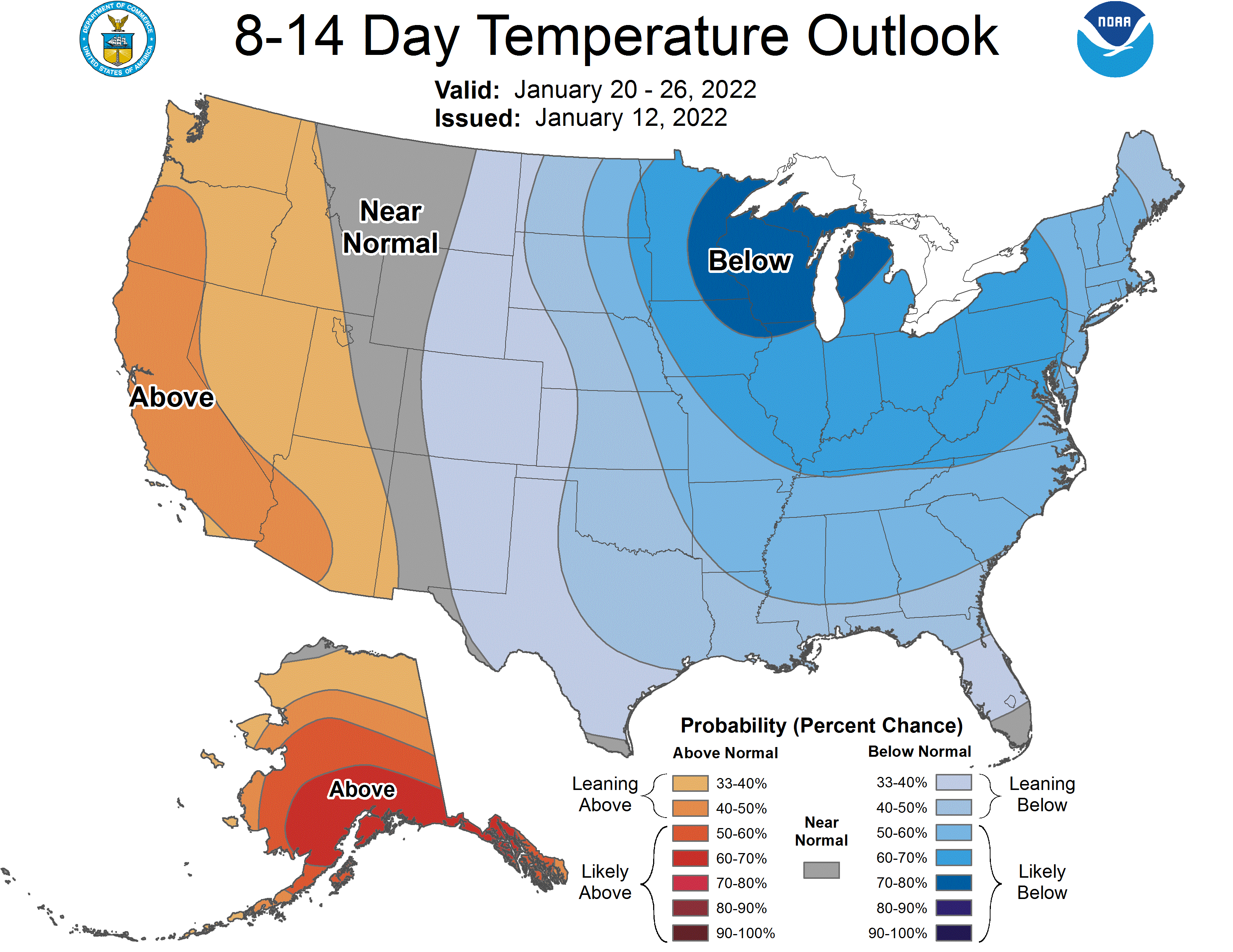
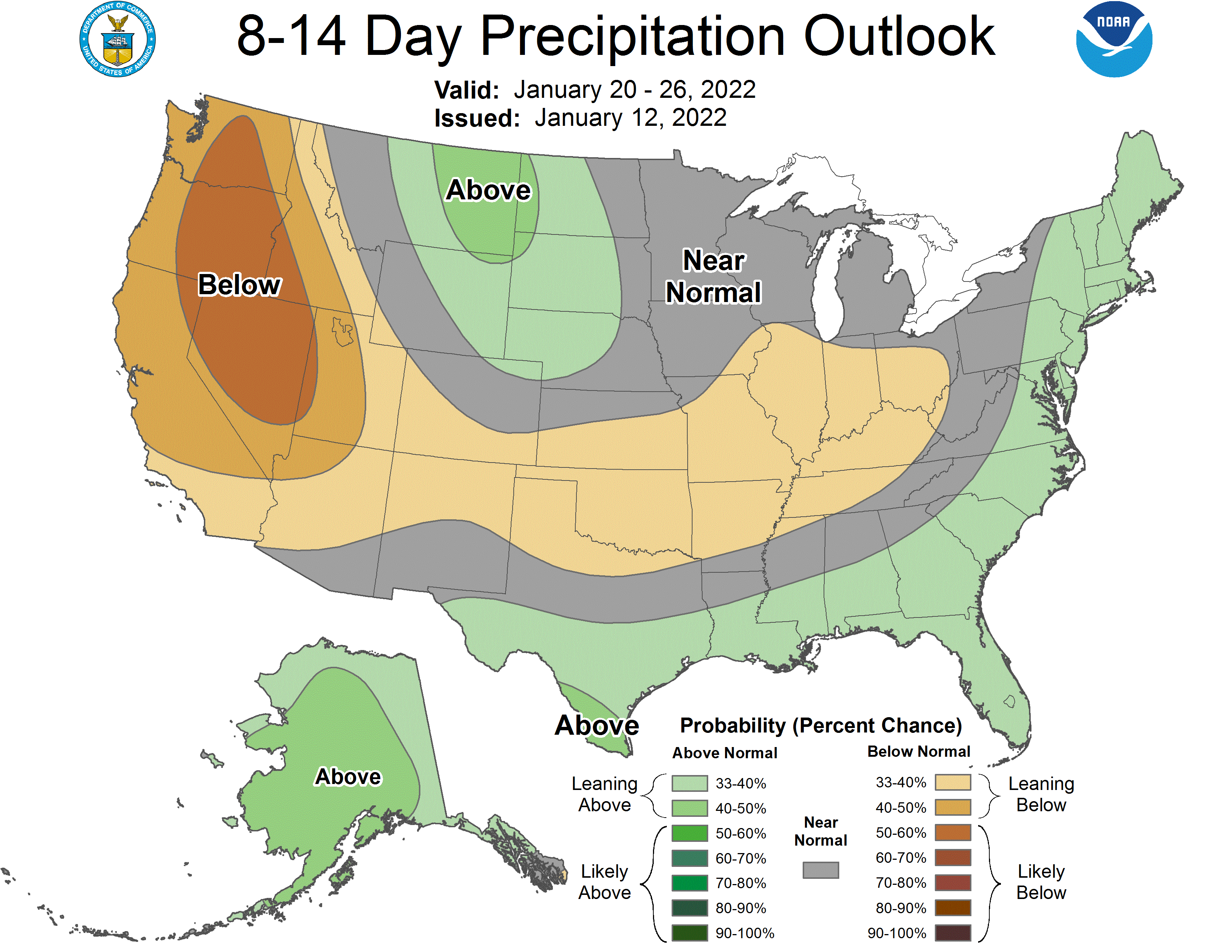
Very fair questions, which I've addressed in past threads like this. Given that this is an RU forum, I think New Brunswick is a good location to look at and the average January snowfall in NB over the 116 years we have records for is 7.1", so the 2nd half of January would be a little over 3.5", on average.

Defining what would be "snowier than normal" could be as little as 7.2", but probably a fairer number might be being in the top quartile of January snowfalls, which would be getting above 10.0" of snow for the month or 5.0" of snow for a half month. So, I'd say if the 2nd half of January is above 5.0", then that would count as "significantly snowier than normal." Others may feel differently - for example getting into the top 10% of Januarys would require 16.7" of snow or 8.4" for a half month. The problem is snowfall is a single-sided non-linear variable, where the range of the top 10% is huge (16-31") while the range for the bottom 10% is tiny (0-0.6") - that's why the median snowfall for January in NB is only 5.0" vs. the average of 7.1".

There's also no agreement on what constitutes a "significant" snowfall. My personal definition has generally been about 4-8", but I think just looking at the total snowfall over the last half of the month is the way to go. I also see little value in having others put up "guesses" as I'm simply interested in whether the actual snowfall is well above normal or not for what looks like a potentially colder and snowier than normal pattern. Obviously, though, others are free to put up their guesses.

http://climate.rutgers.edu/stateclim_v1/monthlydata/index.php?stn=286055&elem=snow

Finally, at this range operational models are fairly useless for guesstimating snowfall even for Sunday's possible event, let alone the 2nd half of the month, given the huge uncertainties introduced by chaos theory for numerical weather predictions, given the known uncertainties in model inputs for initial conditions and boundary conditions. That's why most pros look at ensemble forecasts for any particular model, where the model is perturbed in random ways for the initial and boundary condition inputs, to get a sense of the sensitivity of the model around the operational model run.

And right now, the ensemble mean for the Euro, the best model, is showing well above normal snowfall for the 9th through the 24th (with none of that before the 15th), below, including about 7" for NB, which would be well above the 5" I proposed above for a significantly above normal snowfall for the 2nd half of Jan in NB. That's not a forecast and it may be 100% wrong, but it's simply showing that the potential for snow is much greater than usual (ensembles through Dec were typically showing 1-3" for the next 15 days).

04952C2E-A9B7-4D63-9541-A281EE720BA4.png.e8375c4bf28103645053a259ca97390b.png

Well, the cold pattern looks to be on its way to verifying below normal temps for the 2nd half of January, as temps, so far, combined with the forecast temps through 1/31 will put the 2nd half of the month at about 3-4F below normal. This would clearly put that timeframe in the bottom 1/3 of January average temps (2.7F below normal is the cutoff for being in the coldest 1/3 of Januarys), i.e., it would be considered "below normal."

However, as has been pretty obvious, so far, snowfall for the 95 corridor, as represented by New Brunswick, has not been above normal yet, as we've had 2 chances so far, for snow, and both underperformed. The 1/16 event only gave NB about 0.8" and today's gave 0.2", so that's 1.0" so far vs. the 5.0" NB would get for the 2nd half of January if it was a top quartile January in snowfall.

That's 4" to go and while that's doable in a decent storm, the storm for Saturday has trended from a potential significant event to a non-event and there are no obvious storms in the next 5-6 days. There is something on some model runs for the 1/28-29 timeframe, but that's too far out to really consider. So the snow part isn't looking great at this time, but there's still time to go. It should also be noted that a "snowier than normal" pattern was the thought for the eastern US and large parts of the eastern US have already had well above normal snowfalls for the 2nd half of Jan, but not the 95 corridor in our area, so the pattern has delivered, but just not for us.

Lastly, this will lkely make some posters happy: the long range models indicate a likely pattern flip by early February and the CPC came out with their forecast for February and that forecast is for a warmer than normal pattern, due to a likely persistent trough in the PacNW and ridge in the SE US (opposite of what we have now), as influenced by La Nina, plus a pattern with normal precip amounts. Just like a cold pattern doesn't guarantee snow, a warm pattern doesn't guarantee below average snowfall.

https://www.cpc.ncep.noaa.gov/products/predictions/long_range/lead14/

t14.2c.gif
 
  • Like
Reactions: miket007
Well, the cold pattern looks to be on its way to verifying below normal temps for the 2nd half of January, as temps, so far, combined with the forecast temps through 1/31 will put the 2nd half of the month at about 3-4F below normal. This would clearly put that timeframe in the bottom 1/3 of January average temps (2.7F below normal is the cutoff for being in the coldest 1/3 of Januarys), i.e., it would be considered "below normal."

However, as has been pretty obvious, so far, snowfall for the 95 corridor, as represented by New Brunswick, has not been above normal yet, as we've had 2 chances so far, for snow, and both underperformed. The 1/16 event only gave NB about 0.8" and today's gave 0.2", so that's 1.0" so far vs. the 5.0" NB would get for the 2nd half of January if it was a top quartile January in snowfall.

That's 4" to go and while that's doable in a decent storm, the storm for Saturday has trended from a potential significant event to a non-event and there are no obvious storms in the next 5-6 days. There is something on some model runs for the 1/28-29 timeframe, but that's too far out to really consider. So the snow part isn't looking great at this time, but there's still time to go. It should also be noted that a "snowier than normal" pattern was the thought for the eastern US and large parts of the eastern US have already had well above normal snowfalls for the 2nd half of Jan, but not the 95 corridor in our area, so the pattern has delivered, but just not for us.

Lastly, this will lkely make some posters happy: the long range models indicate a likely pattern flip by early February and the CPC came out with their forecast for February and that forecast is for a warmer than normal pattern, due to a likely persistent trough in the PacNW and ridge in the SE US (opposite of what we have now), as influenced by La Nina, plus a pattern with normal precip amounts. Just like a cold pattern doesn't guarantee snow, a warm pattern doesn't guarantee below average snowfall.

https://www.cpc.ncep.noaa.gov/products/predictions/long_range/lead14/

t14.2c.gif
I tried to read both, your post and your own reply, in one breath.

Couldn’t do it. LOL
 
Well, the cold pattern looks to be on its way to verifying below normal temps for the 2nd half of January, as temps, so far, combined with the forecast temps through 1/31 will put the 2nd half of the month at about 3-4F below normal. This would clearly put that timeframe in the bottom 1/3 of January average temps (2.7F below normal is the cutoff for being in the coldest 1/3 of Januarys), i.e., it would be considered "below normal."

However, as has been pretty obvious, so far, snowfall for the 95 corridor, as represented by New Brunswick, has not been above normal yet, as we've had 2 chances so far, for snow, and both underperformed. The 1/16 event only gave NB about 0.8" and today's gave 0.2", so that's 1.0" so far vs. the 5.0" NB would get for the 2nd half of January if it was a top quartile January in snowfall.

That's 4" to go and while that's doable in a decent storm, the storm for Saturday has trended from a potential significant event to a non-event and there are no obvious storms in the next 5-6 days. There is something on some model runs for the 1/28-29 timeframe, but that's too far out to really consider. So the snow part isn't looking great at this time, but there's still time to go. It should also be noted that a "snowier than normal" pattern was the thought for the eastern US and large parts of the eastern US have already had well above normal snowfalls for the 2nd half of Jan, but not the 95 corridor in our area, so the pattern has delivered, but just not for us.

Lastly, this will lkely make some posters happy: the long range models indicate a likely pattern flip by early February and the CPC came out with their forecast for February and that forecast is for a warmer than normal pattern, due to a likely persistent trough in the PacNW and ridge in the SE US (opposite of what we have now), as influenced by La Nina, plus a pattern with normal precip amounts. Just like a cold pattern doesn't guarantee snow, a warm pattern doesn't guarantee below average snowfall.

https://www.cpc.ncep.noaa.gov/products/predictions/long_range/lead14/

t14.2c.gif
So the roller coaster continues. December was the 2nd warmest ever. An incredible 6.7F above average. I'll take that for February as well.
I also wonder if there is a monthly average wind stat. There never seems to be a calm day anymore and many more days well above 10mph then I remember. Being a outdoor cyclist it's one of the first thing you look for.
Agree with you there.

When working it’s what I look for too.
 
  • Like
Reactions: WhiteBus
So the roller coaster continues. December was the 2nd warmest ever. An incredible 6.7F above average. I'll take that for February as well.
I also wonder if there is a monthly average wind stat. There never seems to be a calm day anymore and many more days well above 10mph then I remember. Being a outdoor cyclist it's one of the first thing you look for.
Yeah, December was off the charts warm pretty much everywhere in the east, which is why there was only one thread on a minor potential snowfall (started by someone else) all month, which didn't pan out.

With regard to wind in December 2021 or any other month, below is a map of the departure from normal for the US and winds were slightly below average in the NE, including Philly in Dec; you can pick any month since 1979 from the link below.

https://www.ncdc.noaa.gov/societal-impacts/wind/

qSEIwV5.png


For specific winds for Philly, the link below gives some very detailed info on winds and gusts on average and for any year or month, so you can look up what you're interested in. For the climatological average see the graph below for Philly, so you can look up specific data and compare it to the average to see when it was windier than normal vs. not.

https://weatherspark.com/h/y/147134...-Pennsylvania-United-States#Figures-WindSpeed

3HFQLUz.png
 
  • Like
Reactions: runrutgersrun
There was a mention of a possible storm on 1/28 to 1/29, how is that looking. I will be traveling a couple hundred miles both days throughout NJ so will be interested for any talk on those days.
 
There was a mention of a possible storm on 1/28 to 1/29, how is that looking. I will be traveling a couple hundred miles both days throughout NJ so will be interested for any talk on those days.
Biggest mid-range signal this winter for a major winter storm for our area. The 1/16 event had an occasional run or two in days 7-9 showing a big storm (mostly on the Euro), but I don't think we ever saw more than 1 model at a time showing that and by the time I started the thread at 4+ days out, it was already looking wetter than white for 95/coast.

For this one, we've seen all 3 (Euro, GFS and CMC; UK only goes out 6 days) of the mid-range models showing some version of a major winter storm for the east coast over the past 2 days (we're at day 7+ now), although not on every run, but still it's a much stronger signal than for 1/16, which turned out to be a helluva winter storm for many - just not for most of us. When I say these models are showing a major storm, note that these runs show different details on who gets snow/rain and how much, although some outputs are snowmageddon for anywhere from GA to ME - and one model showed 6" of snow in the FL Panhandle, which I don't think I've ever seen before. But the only point of model runs at this stage is to see if there's a signal for a significant storm and there is - might not pan out, but the anticipation on the weather boards is the highest I've seen since Jan-16, this far out.

Models are also starting to see some chance of a minor/moderate clipper event next Tues/Weds. Could be a 1-2"/2-4" kind of event if some models are correct, with snow being heaviest north of 195 or maybe N of 78 (most of the precip will be north of the path, which could come close to CNJ). And the CFS long range forecast just said "not so fast" to the idea of a warm February. Will have to see on that one...

https://www.33andrain.com/topic/2046-weather-pattern-storm-threat-discussion-winter-21-22/page/289/
 
  • Like
Reactions: Doteman
Biggest mid-range signal this winter for a major winter storm for our area. The 1/16 event had an occasional run or two in days 7-9 showing a big storm (mostly on the Euro), but I don't think we ever saw more than 1 model at a time showing that and by the time I started the thread at 4+ days out, it was already looking wetter than white for 95/coast.

For this one, we've seen all 3 (Euro, GFS and CMC; UK only goes out 6 days) of the mid-range models showing some version of a major winter storm for the east coast over the past 2 days (we're at day 7+ now), although not on every run, but still it's a much stronger signal than for 1/16, which turned out to be a helluva winter storm for many - just not for most of us. When I say these models are showing a major storm, note that these runs show different details on who gets snow/rain and how much, although some outputs are snowmageddon for anywhere from GA to ME - and one model showed 6" of snow in the FL Panhandle, which I don't think I've ever seen before. But the only point of model runs at this stage is to see if there's a signal for a significant storm and there is - might not pan out, but the anticipation on the weather boards is the highest I've seen since Jan-16, this far out.

Models are also starting to see some chance of a minor/moderate clipper event next Tues/Weds. Could be a 1-2"/2-4" kind of event if some models are correct, with snow being heaviest north of 195 or maybe N of 78 (most of the precip will be north of the path, which could come close to CNJ). And the CFS long range forecast just said "not so fast" to the idea of a warm February. Will have to see on that one...

https://www.33andrain.com/topic/2046-weather-pattern-storm-threat-discussion-winter-21-22/page/289/
Of course they are anticipating seeing this. They are snow weenies. Its like 13 yo boys seeing girls in bikinis. They think they are getting laid.
 
Of course they are anticipating seeing this. They are snow weenies. Its like 13 yo boys seeing girls in bikinis. They think they are getting laid.

so let them be. The fact you and other seem to be so upset about them being excited is strange. As is the fact they’re excited, agree
 
  • Like
Reactions: miket007
ADVERTISEMENT