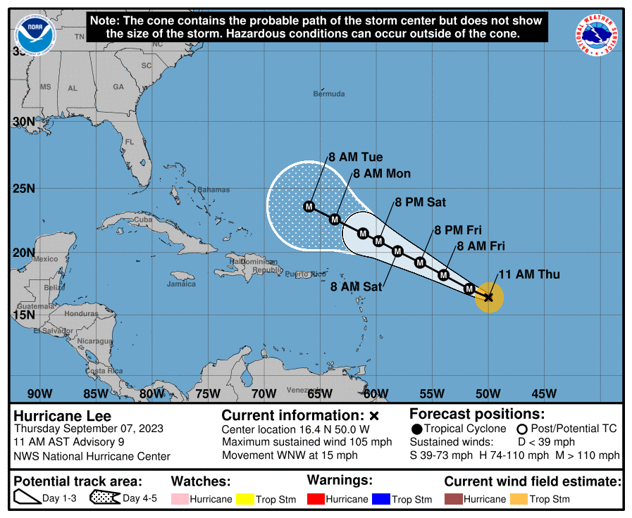
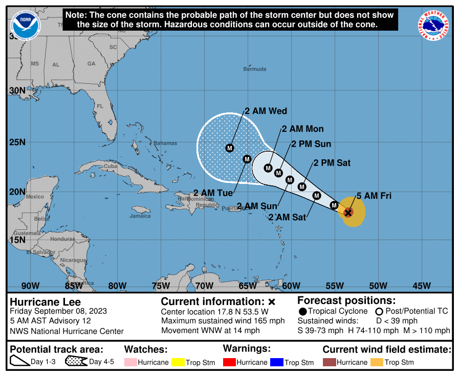
Wow, not only a Cat 2 now, with 105 mph winds, but a strong Cat 2 as Lee is in the midst of a rapid intensification cycle - at this rate will be Cat 4 (130 mph+) by late tonight and Cat 5 by Sunday, but will weaken some after that.
FORECAST POSITIONS AND MAX WINDS
INIT 07/1500Z 16.4N 50.0W 90 KT 105 MPH
12H 08/0000Z 17.1N 51.7W 115 KT 130 MPH
24H 08/1200Z 18.2N 54.0W 130 KT 150 MPH
36H 09/0000Z 19.2N 56.1W 140 KT 160 MPH
48H 09/1200Z 20.1N 58.1W 140 KT 160 MPH
60H 10/0000Z 20.9N 59.8W 135 KT 155 MPH
72H 10/1200Z 21.5N 61.2W 135 KT 155 MPH
96H 11/1200Z 22.6N 63.7W 125 KT 145 MPH
120H 12/1200Z 23.6N 66.0W 120 KT 140 MPH
Wow, from Cat 2 (105 mph) to Cat 4 (130 mph) in 6 hours and from 75 mph to 130 mph in 24 hours, which is a 55 mph increase - and rapid intensification is defined as 35 mph or more increase in 24 hours, so this is just blowing up and it's on its way to Cat 5 strength in the next 12-18 hours (160-165 mph) and is forecast to stay over 150 mph for the next 4 days, before weakening a bit to 140 mph - note that when Lee heads north, it will be going over some cooler waters, due to upwelling from Franklin, so Lee should weaken a bit more as it heads north beyond 5 days. So fortunate that this storm is not directly impacting any land mass over the next 5 days.
So the track forecast is very easy for the next 5 days, as it stays on its WNW track along the southwestern periphery of the strong Western Atlantic Ridge. Then the big questions start. When does it start its northward turn that all the models show and will it slow down around that time - the answers to those two questions will have significant impacts on the downstream track.
As I mentioned earlier we have models ranging from a Nova Scotia landfall to a Newfoundland landfall (or even further NE) in about 9-10 days, which isn't that far from SE New England, and there are ensemble members of these parent models which do strike SE New England and even LI, although those are <10% of the ensemble members as some strike Canada and more than half even miss Canada to the east. Given how far we are from the storm reaching our latitude (8+ days) direct impacts or even a close call can't be ruled out yet from DelMarVa through the NE US (especially New England), but that would be a pretty large surprise still.
In case anyone is curious, the lowest pressure ever in the Atlantic Basin is Wilma @ 882mb (2005) and for sustained winds we had Allen @ 190 mph (1980)...and the deepest hurricane outside of the Gulf/Caribbean was Dorian (2019) at 910 mbar and some think Lee could reach that level.
And recon just recorded a 928 mbar pressure (not in the strongest part of the storm), which could mean the storm is already Cat 5.
https://www.nhc.noaa.gov/graphics_at3.shtml?start#contents
https://www.americanwx.com/bb/topic/59538-category-four-hurricane-lee—130mph953mb/page/16/
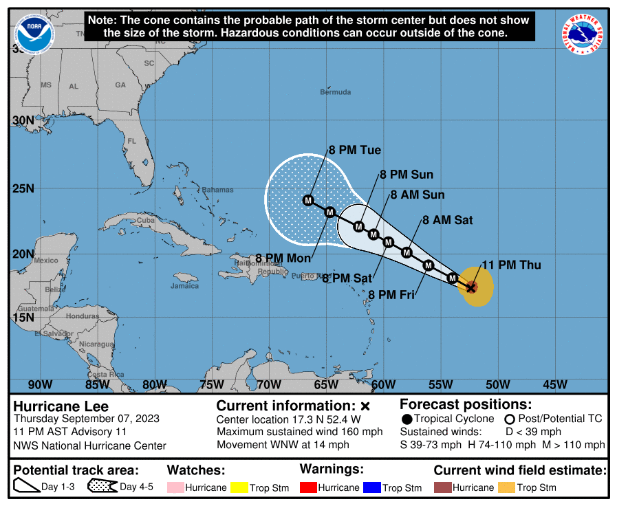
FORECAST POSITIONS AND MAX WINDS
INIT 07/2100Z 16.9N 51.3W 115 KT 130 MPH
12H 08/0600Z 17.6N 53.0W 140 KT 160 MPH
24H 08/1800Z 18.7N 55.2W 145 KT 165 MPH
36H 09/0600Z 19.7N 57.2W 140 KT 160 MPH
48H 09/1800Z 20.6N 59.0W 135 KT 155 MPH
60H 10/0600Z 21.3N 60.5W 135 KT 155 MPH
72H 10/1800Z 22.0N 61.8W 130 KT 150 MPH
96H 11/1800Z 23.1N 64.3W 130 KT 150 MPH
120H 12/1800Z 24.0N 66.4W 120 KT 140 MPH