
It was 71 in Little Rock today. The weather service is calling for snow this weekend!
Colleges
- American Athletic
- Atlantic Coast
- Big 12
- Big East
- Big Ten
- Colonial
- Conference USA
- Independents (FBS)
- Junior College
- Mountain West
- Northeast
- Pac-12
- Patriot League
- Pioneer League
- Southeastern
- Sun Belt
- Army
- Charlotte
- East Carolina
- Florida Atlantic
- Memphis
- Navy
- North Texas
- Rice
- South Florida
- Temple
- Tulane
- Tulsa
- UAB
- UTSA
- Boston College
- California
- Clemson
- Duke
- Florida State
- Georgia Tech
- Louisville
- Miami (FL)
- North Carolina
- North Carolina State
- Pittsburgh
- Southern Methodist
- Stanford
- Syracuse
- Virginia
- Virginia Tech
- Wake Forest
- Arizona
- Arizona State
- Baylor
- Brigham Young
- Cincinnati
- Colorado
- Houston
- Iowa State
- Kansas
- Kansas State
- Oklahoma State
- TCU
- Texas Tech
- UCF
- Utah
- West Virginia
- Illinois
- Indiana
- Iowa
- Maryland
- Michigan
- Michigan State
- Minnesota
- Nebraska
- Northwestern
- Ohio State
- Oregon
- Penn State
- Purdue
- Rutgers
- UCLA
- USC
- Washington
- Wisconsin
High Schools
- Illinois HS Sports
- Indiana HS Sports
- Iowa HS Sports
- Kansas HS Sports
- Michigan HS Sports
- Minnesota HS Sports
- Missouri HS Sports
- Nebraska HS Sports
- Oklahoma HS Sports
- Texas HS Hoops
- Texas HS Sports
- Wisconsin HS Sports
- Cincinnati HS Sports
- Delaware
- Maryland HS Sports
- New Jersey HS Hoops
- New Jersey HS Sports
- NYC HS Hoops
- Ohio HS Sports
- Pennsylvania HS Sports
- Virginia HS Sports
- West Virginia HS Sports
ADVERTISEMENT
OT: Winter Storm Likely to Impact Our Area 1/16-17
- Thread starter RU848789
- Start date
- Status
- Not open for further replies.

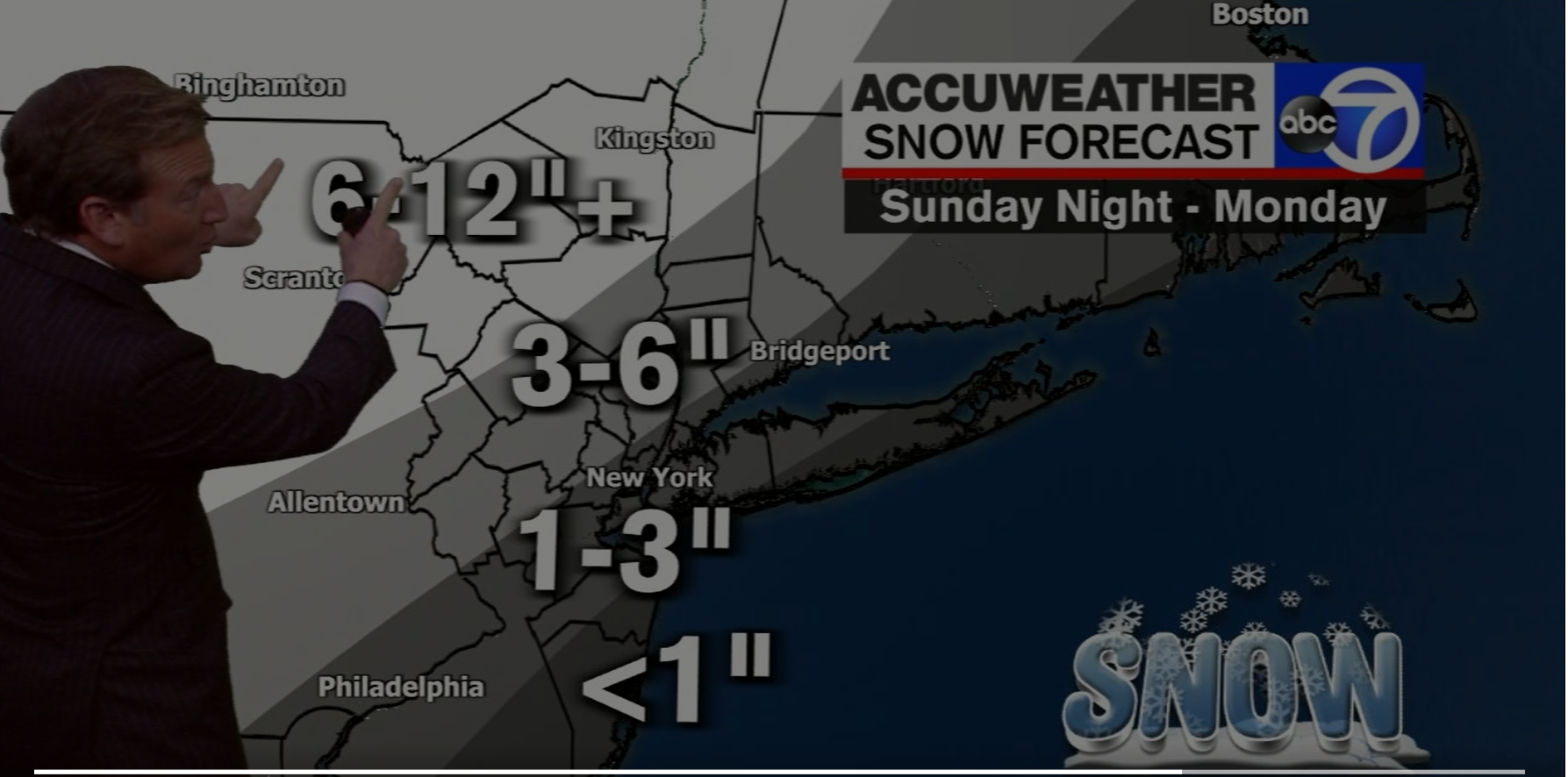
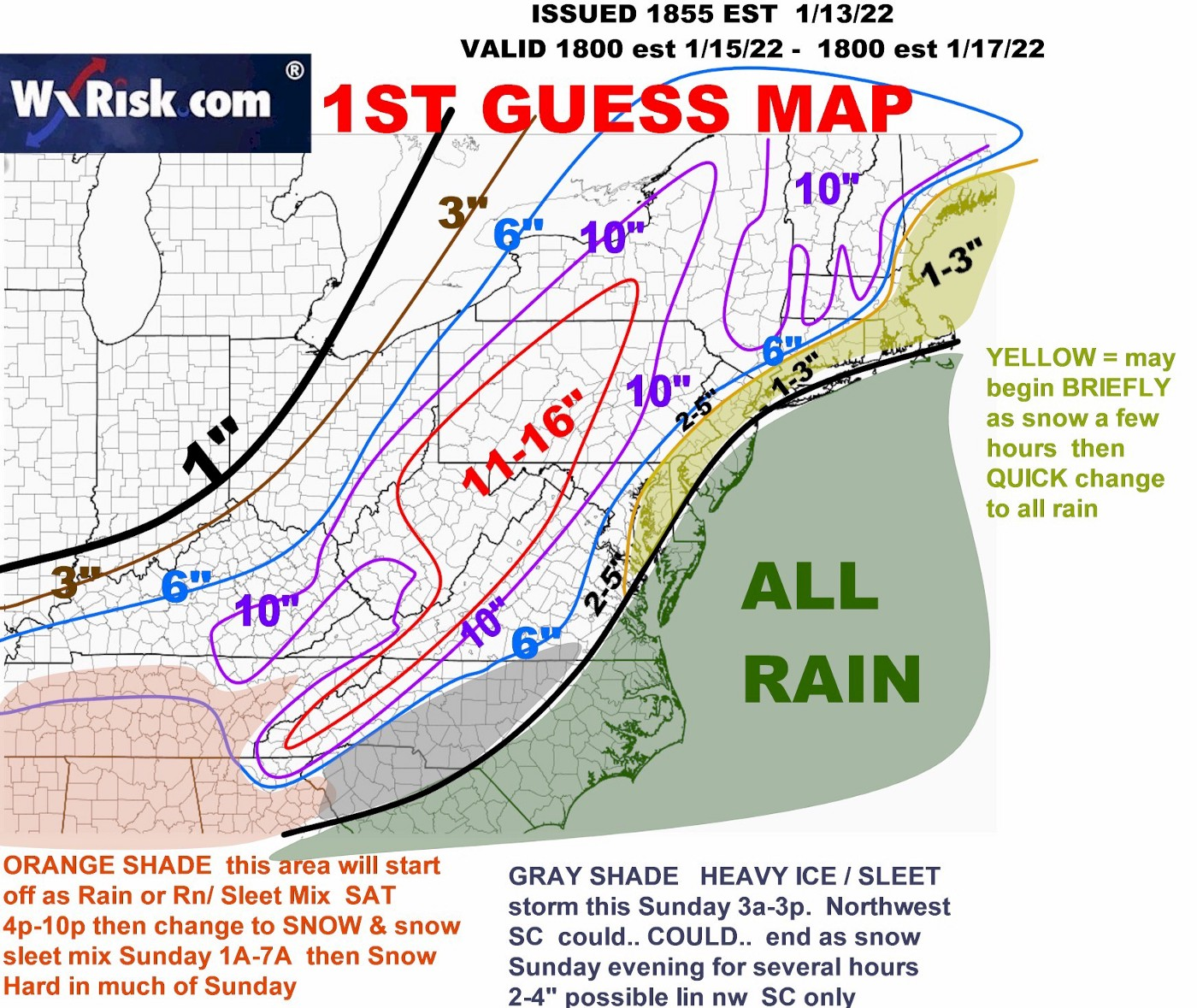
Lee Goldberg put up a preliminary snowfall map with about a 30 mile wide 1-3" swath centered on the 95 corridor from Philly to NYC (with the center essentially being a direct line from Center City to Central Park). The 1" line runs from about Glassboro to to Keansburg to Uniondale (with <1" SE of that line), while the 3" line runs from about King of Prussia to Somerville to White Plains. There is then a 3-6" swath with the 6" line running from about Northampton to Newton to Poughkeepsie and 6-12" NW of that line.
Unfortunately, they haven't put the map up in the latest broadcast on line. Seems reasonable, although maybe a bit too optimistic for the 95 corridor, especially the 1" line being that far SE - could see that being more like right along 95. The good thing, so far, is not too much mention of freezing rain by the NWS or other pros, especially for the 95 corridor.
Edit: map now up. Also, keep in mind that with a general 1" of liquid equivalent falling, that means to get the amount of rain roughly expected, subtract out the snow (at 1" snow per 0.1" liquid), so for someone getting 3" of snow, they're likely going to then get 0.7" of rain (unless they get appreciable sleet too).
Last edited:
72 hours out putting a map up seems pretty pointless given the details will not be ironed out for awhile so take that with a geain of salt
Plus he is the only clown with measurable snow around Philly72 hours out putting a map up seems pretty pointless given the details will not be ironed out for awhile so take that with a geain of salt
Is this a Sunday afternoon start?Lee Goldberg put up a preliminary snowfall map with about a 30 mile wide 1-3" swath centered on the 95 corridor from Philly to NYC (with the center essentially being a direct line from Center City to Central Park). The 1" line runs from about Glassboro to to Keansburg to Uniondale (with <1" SE of that line), while the 3" line runs from about King of Prussia to Somerville to White Plains. There is then a 3-6" swath with the 6" line running from about Northampton to Newton to Poughkeepsie and 6-12" NW of that line.
Unfortunately, they haven't put the map up in the latest broadcast on line. Seems reasonable, although maybe a bit too optimistic for the 95 corridor, especially the 1" line being that far SE - could see that being more like right along 95. The good thing, so far, is not too much mention of freezing rain by the NWS or other pros, especially for the 95 corridor.
Edit: map now up. Also, keep in mind that with a general 1" of liquid equivalent falling, that means to get the amount of rain roughly expected, subtract out the snow (at 1" snow per 0.1" liquid), so for someone getting 3" of snow, they're likely going to then get 0.7" of rain (unless they get appreciable sleet too).
Plus he is the only clown with measurable snow around Philly
that 3-6 map is way south where it should be and he clueless isnt even factoring that much of that would be sleet if its cold enough for frozen
I thought his map was a bit aggressive, as I said above, but I don't think it's way off, since almost every model except the NAM (which is a blowtorch for even the Poconos/Catskills - but it's an outlier) shows 3-6" for at least NW of 80/287 and especially for Warren/Sussex, northern Morris, W. Passaic and the Lehigh Valley/Poconos and western Hudson Valley.that 3-6 map is way south where it should be and he clueless isnt even factoring that much of that would be sleet if its cold enough for frozen
Sunday late afternoon in the Philly area to early evening in the NYC area. According to every model, any snow in the 95 corridor should be over by midnight at the latest (and not much is expected), i.e., it will likely be all rain after that. But if an inch or two happens to fall, roads could be slick in the evening as any snow that falls will accumulate with temps below 32F and it being night time.Is this a Sunday afternoon start?
Late Saturday thru Monday morning we're looking at 8"-12" in the NW corner of NC, more up on the ridges. This'll be our third snowfall of the season, somewhat lagging vs typical winters. This is one of the busiest ski weekends, with the MLK holiday. So lots of flatlander visitors to the High Country. And they'll be drivin' and a slidin' and stuck all over the place. Many from the Sunshine State, of course. Locals affectionately call them "Floridiots." It's a term of endearment, apparently....
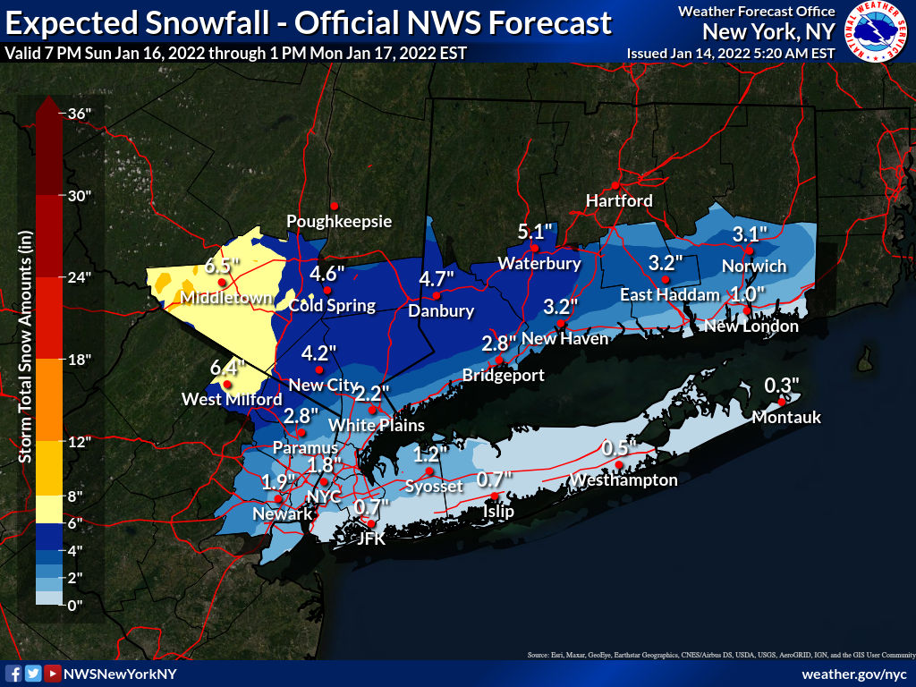
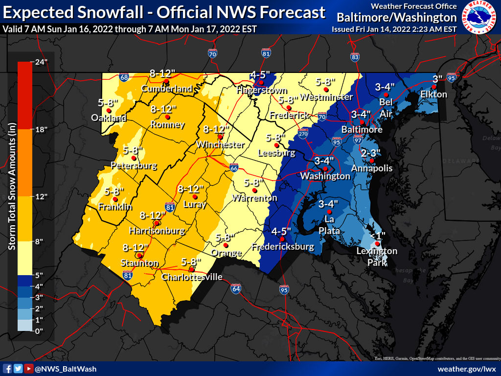
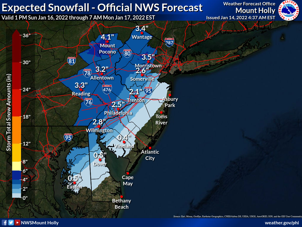
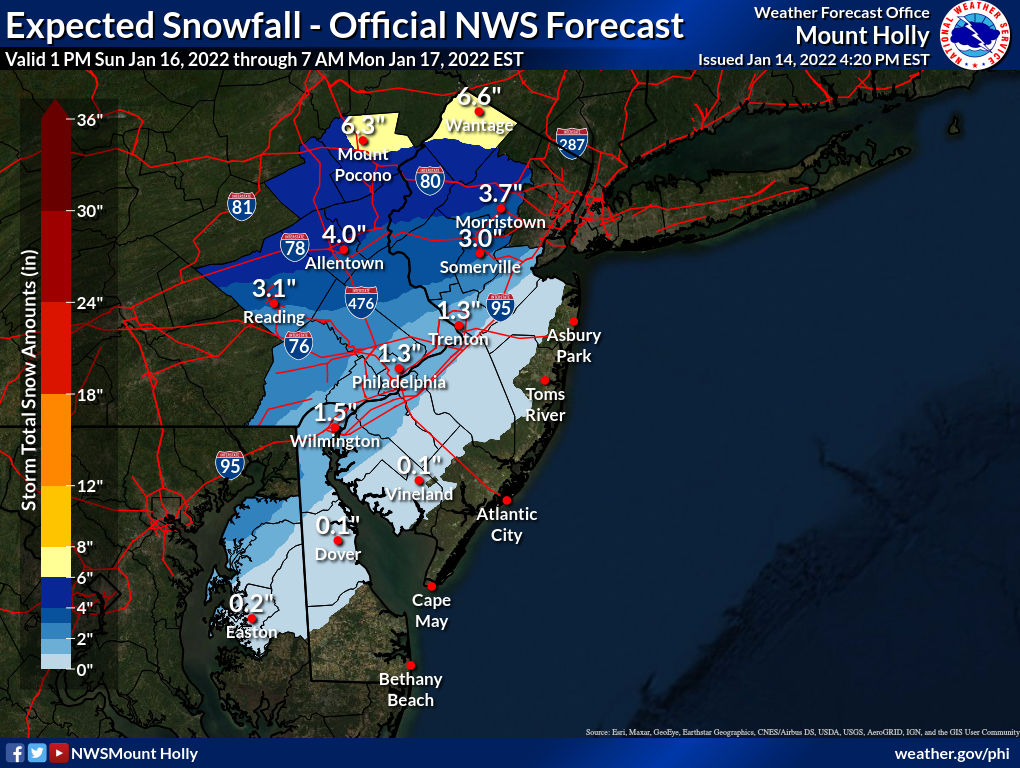
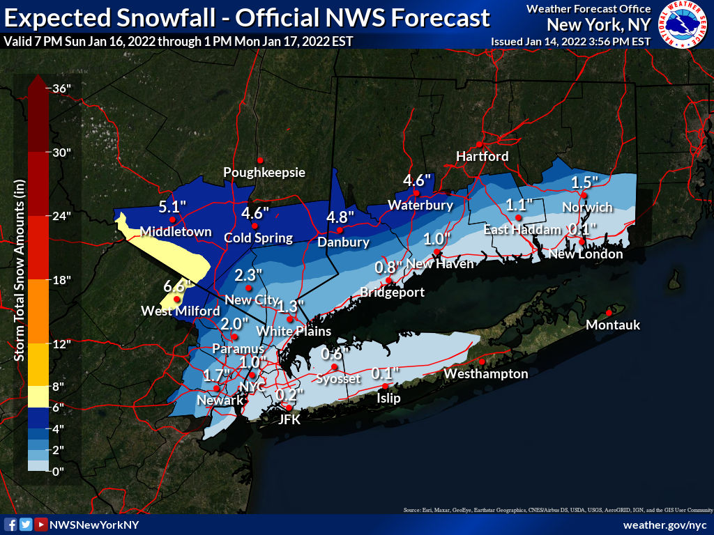
NWS Forecast maps are out for the NYC area and NW Virginia through midday Monday:
The Philly map is only showing through early Monday morning, at which time the storm will still be going on. By the way, showing possible snowfall in tenths of an inch? Really?

The Philly map is only showing through early Monday morning, at which time the storm will still be going on. By the way, showing possible snowfall in tenths of an inch? Really?
No significant changes in last night's 0Z models, as they've actually been aligned quite well for the last 24-36 hours on a track a bit inland from the coast, featuring an initial period of snow for all, followed by a fairly fast changeover to rain along and SE of 95 and progressively slower changeovers to sleet/rain as one moves inland to the NW. Since it'll be very cold all day Saturday and Sunday, with lows both days in the single digits for most (and below 0F wind chills), any snow that falls Sunday evening will easily accumulate before any changeover - how much snowfall depends on how quickly the changeover occurs.Lee Goldberg put up a preliminary snowfall map with about a 30 mile wide 1-3" swath centered on the 95 corridor from Philly to NYC (with the center essentially being a direct line from Center City to Central Park). The 1" line runs from about Glassboro to to Keansburg to Uniondale (with <1" SE of that line), while the 3" line runs from about King of Prussia to Somerville to White Plains. There is then a 3-6" swath with the 6" line running from about Northampton to Newton to Poughkeepsie and 6-12" NW of that line.
Unfortunately, they haven't put the map up in the latest broadcast on line. Seems reasonable, although maybe a bit too optimistic for the 95 corridor, especially the 1" line being that far SE - could see that being more like right along 95. The good thing, so far, is not too much mention of freezing rain by the NWS or other pros, especially for the 95 corridor.
Edit: map now up. Also, keep in mind that with a general 1" of liquid equivalent falling, that means to get the amount of rain roughly expected, subtract out the snow (at 1" snow per 0.1" liquid), so for someone getting 3" of snow, they're likely going to then get 0.7" of rain (unless they get appreciable sleet too).
The NWS has issued their first snowfall maps, below, and these are fairly consistent with the Channel 7 map above, which remains unchanged this morning, at least for the 95 corridor being roughly 1-3". However, the NWS Philly generally just has 3-4/5" NW of 95, all the way to the Poconos/Sussex, while the NWS-NYC ramps the snow up more vigorously NW of 95 with 6+" for places like W. Passaic and Orange, which are adjacent to areas with 3-4" predicted by the NWS-Philly in Sussex/Morris - the offices will need to work this large discrepancy out soon, which is mostly due to the NWS-Philly expecting more sleet, keeping accumulations well inland down. WxRisk/DT's map below is also fairly similar, except for being much more bullish on heavy snows well inland. Personally, I think these maps are a bit overdone and that bust potential is on the high side, as a few models are showing the rain moving in faster with less snow across the board. We'll see.
As mentioned previously, there are beach erosion and coastal flooding concerns, given the astronomical high tides during this period, with minor to perhaps moderate coastal flooding. In addition, winds will kick up on Monday with 40-50 mph gusts possibe (and up to 60 mph along the coast). Finally, with over an inch of rain likely for areas along and SE of 95, we could see localized urban flooding, but stream flooding is less likely, as it's been kind of dry, The NWS-Philly discussion is also below.
https://www.weather.gov/phi/
https://www.33andrain.com/topic/207...er-event/page/71/?tab=comments#comment-302266
Area Forecast Discussion
National Weather Service Mount Holly NJ
623 AM EST Fri Jan 14 2022
SHORT TERM /SATURDAY THROUGH SUNDAY NIGHT/...
Attention remains on the strong storm system expected to impact the
region late Sunday through early Monday. A closed off mid-level wave
will pass from the lower Mississippi Valley Saturday night east
across the interior Southeast Sunday and then north across the Mid-
Atlantic Sunday evening. This will result in an intensification of a
surface low across the Southeast as it moves north across the Mid-
Atlantic. The consensus in the medium range guidance continues with
a storm track well inland, reaching eastern Pennsylvania and new
Jersey by daybreak Monday. Meanwhile, strong, cold, and dry arctic
high pressure will be anchored across New England. A strong pressure
gradient will result across our region late Sunday.
This system will have potential to yield multiple hazards across our
entire forecast area. The initial threat will be a period of snow
and/or sleet at the onset of precipitation, especially along and
north of the I-95 corridor. This still appears to occur Sunday
evening from south to north. Accumulating snow and/or sleet is
anticipated during this time (perhaps even locally heavy at times),
but a changeover to rain is expected to race northwestward as strong
warm air advection ramps up. A transition to rain near I-95 is
anticipated around 10 PM near I-95 (give or take a couple hours).
The 850 mb line appears to reach near or north of I-78 by 2 AM or
so, thus marking a transition to sleet or rain depending on the
depth of the cold air, even all the way into northwest New Jersey
and the southern Poconos.

"In addition, winds will kick up on Monday with 40-50 mph gusts possibe (and up to 60 mph along the coast)." The NWS blurb is as follows - we'll likely see a wind advisory, at least...What’s the deal with the wind?
Within the strong easterly pressure gradient
that develops Sunday evening, guidance remains in fairly good
agreement with onshore (easterly) 925 mb winds 50-60 kts inland to
around the I-95 corridor and 60-70+ kts over the ocean, but
obviously there is a question as to how much of this mixes to the
surface. We`ve seen this kind of setup a couple times within the
past few years though. Nevertheless, this will likely lead to a
period of windy conditions as the LLJ sweeps across the area from
south to north Sunday night, especially along the coasts, across the
coastal plain, and across the higher terrain farther inland.
Thinking gusts of 40-50 mph are possible, with gusts near 60 mph
possible near the coasts during this timeframe. We`ll continue to
monitor this potential of impactful wind gusts. Continued to trend
the forecast winds and gusts upward a bit given that confidence is
increasing on this potential.
What’s the deal with the wind?
It's gon' blow.
yeah what a waste of money. ug
Been seeing it all over Middlesex County… on days when there is no precipitation at all.
Total money grab. BS payola in NJ. And we wonder our taxes are out of control.
What are the chances this storm affects the RU vs Penn St wrestling match at 5pm on Sunday at Penn St? It looks like they are going to get hit hard in central PA and RU would be traveling back to NJ Sunday night through the storm.
For places actually used to and prepared for snow 10" is really no big deal. Travel could be an issue with the gusty winds if they are flying and bus travel will definitely be impacted. Maybe they head out early to get ahead of it.What are the chances this storm affects the RU vs Penn St wrestling match at 5pm on Sunday at Penn St? It looks like they are going to get hit hard in central PA and RU would be traveling back to NJ Sunday night through the storm.
For places actually used to and prepared for snow 10" is really no big deal. Travel could be an issue with the gusty winds if they are flying and bus travel will definitely be impacted. Maybe they head out early to get ahead of it.
the way this storm is trending, even central pa may see mostly rain.
While much of the focus is on the Sunday/Monday system, note that before we get to that, dangerously cold conditions are expected tonight through Saturday night. Please bundle up if you are going outside!


The wind blows. Not in the mood for a gazillion downed wire FD calls.What’s the deal with the wind?
Looking at the NWS Forecast Graph:
EDIT:
The forecast gusts this afternoon in our area are up to 40 mph between 2-7 p.m.
The forecast for gusts from midnight Sunday through early Monday are not much worse.
In my experience, most times, the wind forecasts are remarkably accurate.
National Weather Service
Last edited:
It's actually the bigger story of the next 3 days. Who cares about a rain storm?While much of the focus is on the Sunday/Monday system, note that before we get to that, dangerously cold conditions are expected tonight through Saturday night. Please bundle up if you are going outside!
Some people care about a heavy rainstorm with likely coastal flooding and high winds possibly causing some power outages and others who are in the areas likely to get some to a lot of snow and sleet certainly care about this storm, since it's not just a rainstorm. I've been doing these weather event threads for over 15 years here (and weather emails, which started all of this, for about 25 years) and they've always been focused on the Philly-NJ-NYC region, which includes areas well N/W that are going to get snow/sleet.It's actually the bigger story of the next 3 days. Who cares about a rain storm?
Yes, so what. A portion of the Poconos will get snow. And it isn't a bad thing. They are used to getting more snow, they want more snow for the tourism/sking areas. They get snow every year. It's a big industrySome people care about a heavy rainstorm with likely coastal flooding and high winds possibly causing some power outages and others who are in the areas likely to get some to a lot of snow and sleet certainly care about this storm, since it's not just a rainstorm. I've been doing these weather event threads for over 15 years here (and weather emails, which started all of this, for about 25 years) and they've always been focused on the Philly-NJ-NYC region, which includes areas well N/W that are going to get snow/sleet.
As of now however most all of us are getting rain. Any snow gone by morning. No travel issues, no shoveling etc.
However we haven't seen temps this low in 3 to 4 years. Dangerous temps. Pipes breaking, cars not starting, heaters breaking down because they can't keep up, wind chills below zero. Here is the big difference than the storm. It will effect everyone in PA and NJ and NY. No one is escaping it. It will impact everyone.
Your bias for snow is showing.
Yes, so what. A portion of the Poconos will get snow. And it isn't a bad thing. They are used to getting more snow, they want more snow for the tourism/sking areas. They get snow every year. It's a big industry
As of now however most all of us are getting rain. Any snow gone by morning. No travel issues, no shoveling etc.
However we haven't seen temps this low in 3 to 4 years. Dangerous temps. Pipes breaking, cars not starting, heaters breaking down because they can't keep up, wind chills below zero. Here is the big difference than the storm. It will effect everyone in PA and NJ and NY. No one is escaping it. It will impact everyone.
Your bias for snow is showing.
I’m more interested in the storm itself than the cold temps.
you seem to have crazy issues with #s and his posts, so maybe just don’t view the threads??
The forecasted wind is what has people concerned for Monday. But you're right, cold isn't fun either as I had the furnace go out on Tuesday - up and running again after a repair.Yes, so what. A portion of the Poconos will get snow. And it isn't a bad thing. They are used to getting more snow, they want more snow for the tourism/sking areas. They get snow every year. It's a big industry
As of now however most all of us are getting rain. Any snow gone by morning. No travel issues, no shoveling etc.
However we haven't seen temps this low in 3 to 4 years. Dangerous temps. Pipes breaking, cars not starting, heaters breaking down because they can't keep up, wind chills below zero. Here is the big difference than the storm. It will effect everyone in PA and NJ and NY. No one is escaping it. It will impact everyone.
Your bias for snow is showing.
Where I live, I'd rather have snow than this wind and rain. The ash trees will be dropping like flies all weekend. Pretty much guaranteed to lose power.Yes, so what. A portion of the Poconos will get snow. And it isn't a bad thing. They are used to getting more snow, they want more snow for the tourism/sking areas. They get snow every year. It's a big industry
As of now however most all of us are getting rain. Any snow gone by morning. No travel issues, no shoveling etc.
However we haven't seen temps this low in 3 to 4 years. Dangerous temps. Pipes breaking, cars not starting, heaters breaking down because they can't keep up, wind chills below zero. Here is the big difference than the storm. It will effect everyone in PA and NJ and NY. No one is escaping it. It will impact everyone.
Your bias for snow is showing.
the wind is going to be an issue and quite frankly the snow amounts are pretty much overdone on some of these maps, focus on the wind and the upcoming cold
I didn't respond to him at all in this thread initially, he responded to my post. Sorry but you have it backwards. Our first battle was him going bizerck on me because I called out the Philadelphia media for over hyping a storm. Go ask him way he has an issue.I’m more interested in the storm itself than the cold temps.
you seem to have crazy issues with #s and his posts, so maybe just don’t view the threads??
It would have been hotel weekend without a furnace tomorrow, glad you got it fixed in time.The forecasted wind is what has people concerned for Monday. But you're right, cold isn't fun either as I had the furnace go out on Tuesday - up and running again after a repair.
Thanks. It's amazing how many small parts there are in a furnace that can still be the difference between you freezing your a$$ off in 20 degree temperatures or staying warm.It would have been hotel weekend without a furnace tomorrow, glad you got it fixed in time.

Most forecasters have the Lehigh Valley, NWNJ (Warren/Sussex/Morris/Passaic) and the Hudson Valley getting at least several inches of snow and sleet and perhaps not much rain (which may just be absorbed in the snow/sleet pack, not washing away), so it's not just the Poconos - and these people are interested in that forecast, as there will be travel/removal impacts.Yes, so what. A portion of the Poconos will get snow. And it isn't a bad thing. They are used to getting more snow, they want more snow for the tourism/sking areas. They get snow every year. It's a big industry
As of now however most all of us are getting rain. Any snow gone by morning. No travel issues, no shoveling etc.
However we haven't seen temps this low in 3 to 4 years. Dangerous temps. Pipes breaking, cars not starting, heaters breaking down because they can't keep up, wind chills below zero. Here is the big difference than the storm. It will effect everyone in PA and NJ and NY. No one is escaping it. It will impact everyone.
Your bias for snow is showing.
Also, the forecast lows in Philly are 11 and 13 the next two nights, which is slightly colder than the last 2 year's coldest, but 7 of the previous 9 years saw single digit lows which were colder and 80 of the last 100 years saw temps in the single digits, so 11 and 13 aren't that unusual. Plus, the only places with wind chill advisories are the Poconos and Sussex and Philly is pretty far from conditions for an advisory. Yeah it's cold, but most barely give that a 2nd thought unless they work outside or are one of the few unfortunate enough to lose heat - but far more lose power/heat from wind/snow than cold.
| 5 | January 31, 2019 | -15 |
| 4 | January 07, 2018 | -16 |
| 9 | December 31, 2017 | -13 |
| 8 | February 14, 2016 | -13 |
| 2 | February 20, 2015 | -17 |
| 4 | January 22, 2014 + | -16 |
| 12 | January 23, 2013 | -11 |
| 14 | January 04, 2012 | -10 |
| 8 | January 24, 2011 | -13 |
No significant changes in last night's 0Z models, as they've actually been aligned quite well for the last 24-36 hours on a track a bit inland from the coast, featuring an initial period of snow for all, followed by a fairly fast changeover to rain along and SE of 95 and progressively slower changeovers to sleet/rain as one moves inland to the NW. Since it'll be very cold all day Saturday and Sunday, with lows both days in the single digits for most (and below 0F wind chills), any snow that falls Sunday evening will easily accumulate before any changeover - how much snowfall depends on how quickly the changeover occurs.
The NWS has issued their first snowfall maps, below, and these are fairly consistent with the Channel 7 map above, which remains unchanged this morning, at least for the 95 corridor being roughly 1-3". However, the NWS Philly generally just has 3-4/5" NW of 95, all the way to the Poconos/Sussex, while the NWS-NYC ramps the snow up more vigorously NW of 95 with 6+" for places like W. Passaic and Orange, which are adjacent to areas with 3-4" predicted by the NWS-Philly in Sussex/Morris - the offices will need to work this large discrepancy out soon, which is mostly due to the NWS-Philly expecting more sleet, keeping accumulations well inland down. WxRisk/DT's map below is also fairly similar, except for being much more bullish on heavy snows well inland. Personally, I think these maps are a bit overdone and that bust potential is on the high side, as a few models are showing the rain moving in faster with less snow across the board. We'll see.
As mentioned previously, there are beach erosion and coastal flooding concerns, given the astronomical high tides during this period, with minor to perhaps moderate coastal flooding. In addition, winds will kick up on Monday with 40-50 mph gusts possibe (and up to 60 mph along the coast). Finally, with over an inch of rain likely for areas along and SE of 95, we could see localized urban flooding, but stream flooding is less likely, as it's been kind of dry, The NWS-Philly discussion is also below.
https://www.weather.gov/phi/
https://www.33andrain.com/topic/207...er-event/page/71/?tab=comments#comment-302266
Area Forecast Discussion
National Weather Service Mount Holly NJ
623 AM EST Fri Jan 14 2022
SHORT TERM /SATURDAY THROUGH SUNDAY NIGHT/...
Attention remains on the strong storm system expected to impact the
region late Sunday through early Monday. A closed off mid-level wave
will pass from the lower Mississippi Valley Saturday night east
across the interior Southeast Sunday and then north across the Mid-
Atlantic Sunday evening. This will result in an intensification of a
surface low across the Southeast as it moves north across the Mid-
Atlantic. The consensus in the medium range guidance continues with
a storm track well inland, reaching eastern Pennsylvania and new
Jersey by daybreak Monday. Meanwhile, strong, cold, and dry arctic
high pressure will be anchored across New England. A strong pressure
gradient will result across our region late Sunday.
This system will have potential to yield multiple hazards across our
entire forecast area. The initial threat will be a period of snow
and/or sleet at the onset of precipitation, especially along and
north of the I-95 corridor. This still appears to occur Sunday
evening from south to north. Accumulating snow and/or sleet is
anticipated during this time (perhaps even locally heavy at times),
but a changeover to rain is expected to race northwestward as strong
warm air advection ramps up. A transition to rain near I-95 is
anticipated around 10 PM near I-95 (give or take a couple hours).
The 850 mb line appears to reach near or north of I-78 by 2 AM or
so, thus marking a transition to sleet or rain depending on the
depth of the cold air, even all the way into northwest New Jersey
and the southern Poconos.
12Z models are pretty similar to the 0Z models, so not much change in the NWS snowfall maps, other than the Philly office bumping up snowfall amounts well NW (Sussex/Poconos) to match what NWS-NYC has for Orange/Passaic counties - and keep in mind those numbers could be a fair amount less if sleet comes earlier as some think will occur (as per the NAM), although sleet is just as impactful on roads and for removal as snow (but not a visibility issue).
Because of the increases, the NWS issued winter storm watches for Sussex and Carbon/Monroe (Poconos) for 5-7" of snow/sleet (and possibly freezing rain accumulations of 0.1"). A bit surprised the NWS didn't cut back snow for the 95 corridor, but their thinking is it's going to still be pretty cold at the start so a few hours of snow could easily get 1-3" before the deluge.
All the other threats are still there too: coastal flooding being minor to moderate with the astronomical high tide, high winds (up to 60 mph gusts near the coast), which could cause power outages, and heavy rains leading to localized urban flooding (1" or more where it's mostly rain).
https://forecast.weather.gov/produc...&format=CI&version=1&glossary=1&highlight=off
That's me....Also, the forecast lows in Philly are 11 and 13 the next two nights, which is slightly colder than the last 2 year's coldest, but 7 of the previous 9 years saw single digit lows which were colder and 80 of the last 100 years saw temps in the single digits, so 11 and 13 aren't that unusual. Plus, the only places with wind chill advisories are the Poconos and Sussex and Philly is pretty far from conditions for an advisory. Yeah it's cold, but most barely give that a 2nd thought unless they work outside or are one of the few unfortunate enough to lose heat - but far more lose power/heat from wind/snow than cold.
The forecasted wind is what has people concerned for Monday. But you're right, cold isn't fun either as I had the furnace go out on Tuesday - up and running again after a repair.
the wind is going to be an issue and quite frankly the snow amounts are pretty much overdone on some of these maps, focus on the wind and the upcoming cold
and a few others with this concern too.Where I live, I'd rather have snow than this wind and rain. The ash trees will be dropping like flies all weekend. Pretty much guaranteed to lose power.
Like the song says, "Let It Snow!" but the other stuff can make it a lot worse than your typical Winter Wonderland look and feel to it.
Last edited:
Thankfully this isn't the highest lunar tide of the month, that comes in 2 weeks but with the current projections are all over the place it may not matter. Going to have to watch closely around here.12Z models are pretty similar to the 0Z models, so not much change in the NWS snowfall maps, other than the Philly office bumping up snowfall amounts well NW (Sussex/Poconos) to match what NWS-NYC has for Orange/Passaic counties - and keep in mind those numbers could be a fair amount less if sleet comes earlier as some think will occur (as per the NAM), although sleet is just as impactful on roads and for removal as snow (but not a visibility issue).
Because of the increases, the NWS issued winter storm watches for Sussex and Carbon/Monroe (Poconos) for 5-7" of snow/sleet (and possibly freezing rain accumulations of 0.1"). A bit surprised the NWS didn't cut back snow for the 95 corridor, but their thinking is it's going to still be pretty cold at the start so a few hours of snow could easily get 1-3" before the deluge.
All the other threats are still there too: coastal flooding being minor to moderate with the astronomical high tide, high winds (up to 60 mph gusts near the coast), which could cause power outages, and heavy rains leading to localized urban flooding (1" or more where it's mostly rain).
https://forecast.weather.gov/produc...&format=CI&version=1&glossary=1&highlight=off
Did you see the wind chart @Postman_1 shared with us?Thankfully this isn't the highest lunar tide of the month, that comes in 2 weeks but with the current projections are all over the place it may not matter. Going to have to watch closely around here.
News12, who I've never been a big fan of, has a goofy snowfall map, with 1-2" for the 95 corridor, with the 1" line being from about Glassboro to Sandy Hook and the 2" line being from about Frenchtown to Nyack, and 3-6" NW of the 2" line - that's just sloppy work, since that's discontinuous. Either needs to be 1-2"/2-6" or 1-3"/3-6" for continuity or add a 2-3" swath.
Hey, maybe it's time for a visit from @RUJohnny...
Hey, maybe it's time for a visit from @RUJohnny...
12Z models are pretty similar to the 0Z models, so not much change in the NWS snowfall maps, other than the Philly office bumping up snowfall amounts well NW (Sussex/Poconos) to match what NWS-NYC has for Orange/Passaic counties - and keep in mind those numbers could be a fair amount less if sleet comes earlier as some think will occur (as per the NAM), although sleet is just as impactful on roads and for removal as snow (but not a visibility issue).
Because of the increases, the NWS issued winter storm watches for Sussex and Carbon/Monroe (Poconos) for 5-7" of snow/sleet (and possibly freezing rain accumulations of 0.1"). A bit surprised the NWS didn't cut back snow for the 95 corridor, but their thinking is it's going to still be pretty cold at the start so a few hours of snow could easily get 1-3" before the deluge.
All the other threats are still there too: coastal flooding being minor to moderate with the astronomical high tide, high winds (up to 60 mph gusts near the coast), which could cause power outages, and heavy rains leading to localized urban flooding (1" or more where it's mostly rain).
https://forecast.weather.gov/produc...&format=CI&version=1&glossary=1&highlight=off
I would be floored if Somerville received 3 inches
- Status
- Not open for further replies.
Similar threads
- Replies
- 748
- Views
- 37K
- Replies
- 44
- Views
- 3K
ADVERTISEMENT
ADVERTISEMENT