So I guess this means no snow. Who knew??? 4 pages of yippity yap.
Colleges
- American Athletic
- Atlantic Coast
- Big 12
- Big East
- Big Ten
- Colonial
- Conference USA
- Independents (FBS)
- Junior College
- Mountain West
- Northeast
- Pac-12
- Patriot League
- Pioneer League
- Southeastern
- Sun Belt
- Army
- Charlotte
- East Carolina
- Florida Atlantic
- Memphis
- Navy
- North Texas
- Rice
- South Florida
- Temple
- Tulane
- Tulsa
- UAB
- UTSA
- Boston College
- California
- Clemson
- Duke
- Florida State
- Georgia Tech
- Louisville
- Miami (FL)
- North Carolina
- North Carolina State
- Pittsburgh
- Southern Methodist
- Stanford
- Syracuse
- Virginia
- Virginia Tech
- Wake Forest
- Arizona
- Arizona State
- Baylor
- Brigham Young
- Cincinnati
- Colorado
- Houston
- Iowa State
- Kansas
- Kansas State
- Oklahoma State
- TCU
- Texas Tech
- UCF
- Utah
- West Virginia
- Illinois
- Indiana
- Iowa
- Maryland
- Michigan
- Michigan State
- Minnesota
- Nebraska
- Northwestern
- Ohio State
- Oregon
- Penn State
- Purdue
- Rutgers
- UCLA
- USC
- Washington
- Wisconsin
High Schools
- Illinois HS Sports
- Indiana HS Sports
- Iowa HS Sports
- Kansas HS Sports
- Michigan HS Sports
- Minnesota HS Sports
- Missouri HS Sports
- Nebraska HS Sports
- Oklahoma HS Sports
- Texas HS Hoops
- Texas HS Sports
- Wisconsin HS Sports
- Cincinnati HS Sports
- Delaware
- Maryland HS Sports
- New Jersey HS Hoops
- New Jersey HS Sports
- NYC HS Hoops
- Ohio HS Sports
- Pennsylvania HS Sports
- Virginia HS Sports
- West Virginia HS Sports
ADVERTISEMENT
You are using an out of date browser. It may not display this or other websites correctly.
You should upgrade or use an alternative browser.
You should upgrade or use an alternative browser.
OT: Winter Storm Likely to Impact Our Area 1/16-17
- Thread starter RU848789
- Start date
- Status
- Not open for further replies.
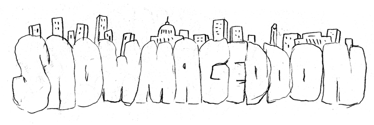
Hah! Our local forecast in Boone NC is trending toward a full-on "Snowmageddon"! 24-inches with more locally on ridge tops. And 30 mph winds. Locals are on "Cantore"-watch. Anyway, the fun starts later on, after midnight, lasting to mid-Monday. Bring it on!
I like leaving the snow blower in the garage,So I guess this means no snow. Who knew??? 4 pages of yippity yap.
Hah! Our local forecast in Boone NC is trending toward a full-on "Snowmageddon"! 24-inches with more locally on ridge tops. And 30 mph winds. Locals are on "Cantore"-watch. Anyway, the fun starts later on, after midnight, lasting to mid-Monday. Bring it on!
Tri-State are now supposed to get the wind, maybe even a little higher, but be on the rain side of the snow-rain divide.
So I guess this means no snow. Who knew??? 4 pages of yippity yap.

His name was RUinPinehurst. RIP.Hah! Our local forecast in Boone NC is trending toward a full-on "Snowmageddon"! 24-inches with more locally on ridge tops. And 30 mph winds. Locals are on "Cantore"-watch. Anyway, the fun starts later on, after midnight, lasting to mid-Monday. Bring it on!
It’s a hard concept to understand but some of us who live in parts of NJ that were not getting much snow maybe had plans to travel to the impact areas this long weekend, and value Numbers’ work.
Agree . I appreciate numbers, bac, and others inputIt’s a hard concept to understand but some of us who live in parts of NJ that were not getting much snow maybe had plans to travel to the impact areas this long weekend, and value Numbers’ work.
+1Agree . I appreciate numbers, bac, and others input
Great job by Bac and Tango!
How long have these 3 been jockeying over weather threads? 20 years? More?+1
Great job by Bac and Tango!
-Who gets to start one first..
-When the right time to start one is
-Snow Weenies
-Whether or not they make "predictions"
-Whether or not they are accurate
-Whether or not they own up to being wrong about predictions they did or did not make
-Who thinks weather has anything to do with climate change and so on
-Who trolls whom first
Do you mean 24!! Or 2-4?Hah! Our local forecast in Boone NC is trending toward a full-on "Snowmageddon"! 24-inches with more locally on ridge tops. And 30 mph winds. Locals are on "Cantore"-watch. Anyway, the fun starts later on, after midnight, lasting to mid-Monday. Bring it on!
24“ Boone NC has significant elevationDo you mean 24!! Or 2-4?
Quarantine her
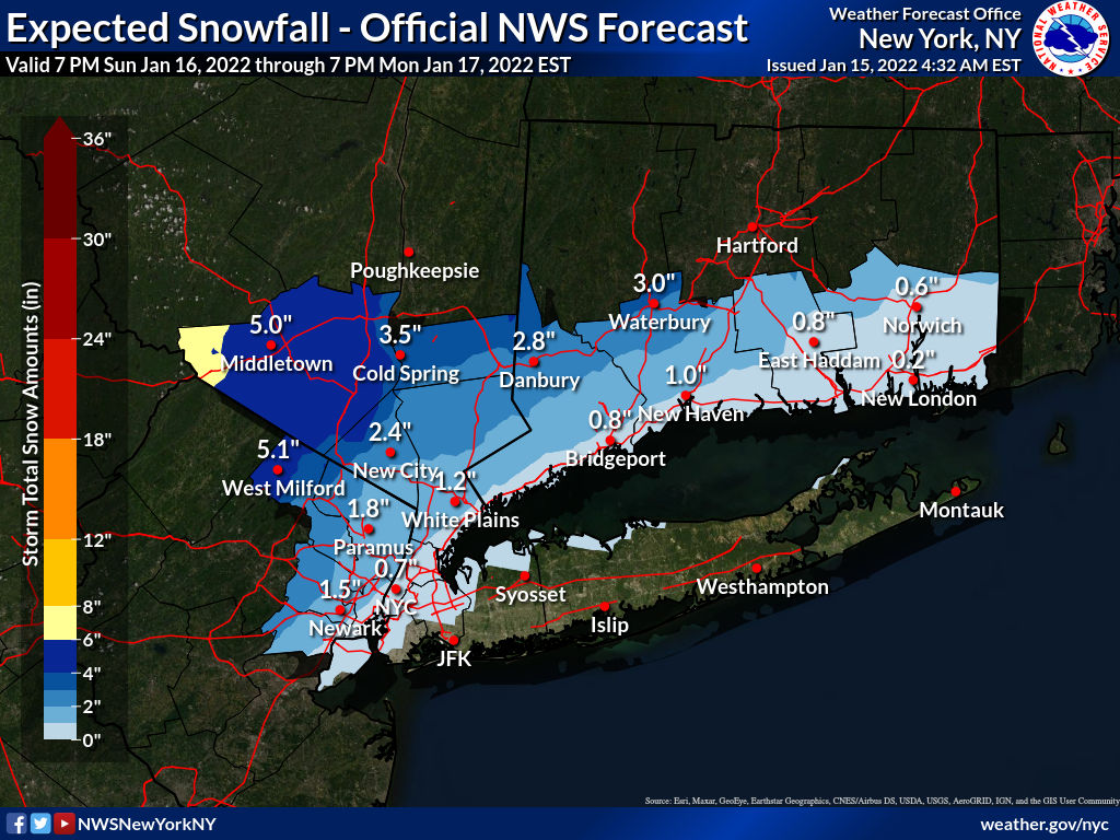
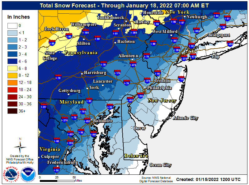
Had a gut feeling a few days ago about WAA ruining the party.The NWS-NYC updated theirsnowfall map this morning and it shows a bit less snow for everyone, mostly due to more warm air advection aloft, leading to more sleet. The NWS-Philly has said they've also cut back snowfall amounts for the same reason, but haven't yet updated their snowfall map for some reason, but the NWS Eastern Region map has updated and is also below. Precip will likely start in the early evening as snow for most and then quickly change over to sleet, then rain through the 95 corridor and even a bit inland and go into Monday morning; the changeover will be overnight well N/W of 95. And if the NAM/RDPS (RGEM) are right (and they often do well in these setups), snowfall numbers everywhere, even into central PA/NY will be much less than shown in other models, due to this warm air at 850 mbar (~5000 feet up) leading to much more sleet - still a wintry event with the same frozen mass, but not as much snow.
For the 95 corridor and just NW of 95, and the coast, especially, the main story will be the heavy rainfall (1-1.5") possibly causing localized urban flooding and the strong winds late Sunday/early Monday which will gust to 40-50 mph and near 60 mph at the coast, possibly leading to some power outages - a wind advisory will likely be issues soon. In addition there is a coastal flood watch up for Monmouth/Middlesex, NENJ, NYC and LI/CT for minor to possible moderate flooding, especially with Monday morning's high tide, as per the link below.
Temps bottomed out in the low/mid teens along and SE of the 95 corridor this morning (11F in NB and 16F in Philly) and in the single digits NW of 95, with the wind chill advisory still being up for the Poconos/Sussex for wind chills of -10 to -20F this morning. Temps will likely be a couple of degrees colder Sunday morning.
https://forecast.weather.gov/wwamap/wwatxtget.php?cwa=phi&wwa=coastal flood watch
https://www.weather.gov/phi/
The town of Boone is at 3333-feet in elevation. I'm on the mountain above town at 4600-feet. Local forecasts focus on in-town conditions but also provide guidance for local ridgelines, too.24“ Boone NC has significant elevation
His name was RUinPinehurst. RIP.
He'll survive the blizzard. He's vaccinated.
Don't invite me over to ride my bicycle in your area. 😂The town of Boone is at 3333-feet in elevation. I'm on the mountain above town at 4600-feet. Local forecasts focus on in-town conditions but also provide guidance for local ridgelines, too.
I hate hills. Although that's all I do in the winter. Shorter rides (around 25 miles) needs a tougher workout.
Each Fall there's a fundraiser "fun run" up Junaluska Road to Howard Knob from King Street (downtown). The race is up a steep winding mountain road, a gain of approx 1500-feet. It's marketed as "Three Miles of Pure Hill." LOL. I'll trek down to town and back using an extended version of that route, about a 7-mile roundtrip. Good workout. On occasion I'll encounter a cyclist attempting to go up that stretch. It's kinda comical. Nearby Blue Ridge Parkway offers terrific biking, though.Don't invite me over to ride my bicycle in your area. 😂
I hate hills. Although that's all I do in the winter. Shorter rides (around 25 miles) needs a tougher workout.
Don't forget:How long have these 3 been jockeying over weather threads? 20 years? More?
-Who gets to start one first..
-When the right time to start one is
-Snow Weenies
-Whether or not they make "predictions"
-Whether or not they are accurate
-Whether or not they own up to being wrong about predictions they did or did not make
-Who thinks weather has anything to do with climate change and so on
-Who trolls whom first
NWS:
Here is the latest briefing on the storm system moving in tomorrow evening. Some new products have been issued but there have been no big changes to the forecast. You may need to refresh the page for the latest version to appear.
Here is the latest briefing on the storm system moving in tomorrow evening. Some new products have been issued but there have been no big changes to the forecast. You may need to refresh the page for the latest version to appear.
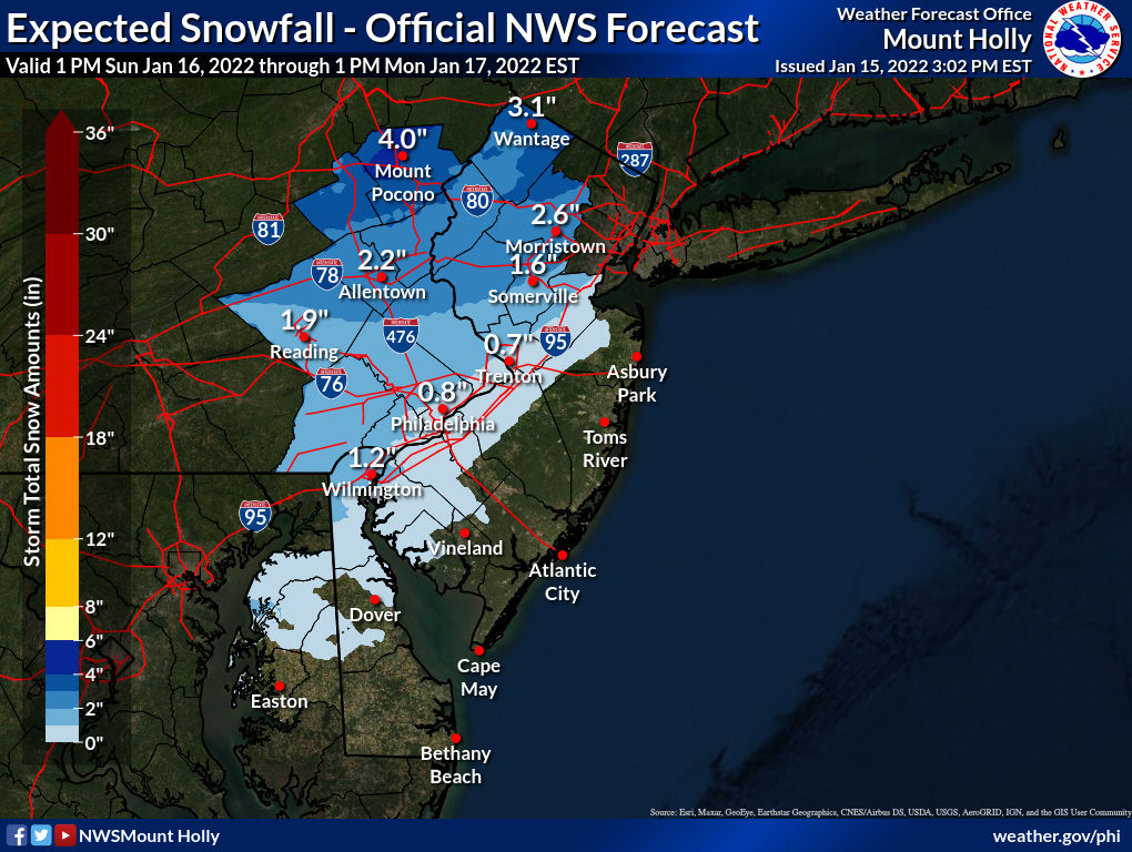
No surprise that the NWS cut snowfall amounts again, given what the models are showing. The 1" line now essentially runs up 95 and the 3" or more amounts are generally confined to being north of I-80. Likely a fair amount of sleet in locations N of 78 and especially N of 80, and sleet is no picnic either (same mass as snow, just less depth). Hopefully we can avoid much freezing rain as that shit's just nasty, but up to 0.1" is forecast during the transition in the counties with advisories just NW of 95. All the other impacts are still expected, i.e., high winds, coastal flooding, heavy rain/urban flooding. Nice win today by RU...The NWS-NYC updated theirsnowfall map this morning and it shows a bit less snow for everyone, mostly due to more warm air advection aloft, leading to more sleet. The NWS-Philly has said they've also cut back snowfall amounts for the same reason, but haven't yet updated their snowfall map for some reason, but the NWS Eastern Region map has updated and is also below. Precip will likely start in the early evening as snow for most and then quickly change over to sleet, then rain through the 95 corridor and even a bit inland and go into Monday morning; the changeover will be overnight well N/W of 95. And if the NAM/RDPS (RGEM) are right (and they often do well in these setups), snowfall numbers everywhere, even into central PA/NY will be much less than shown in other models, due to this warm air at 850 mbar (~5000 feet up) leading to much more sleet - still a wintry event with the same frozen mass, but not as much snow.
For the 95 corridor and just NW of 95, and the coast, especially, the main story will be the heavy rainfall (1-1.5") possibly causing localized urban flooding and the strong winds late Sunday/early Monday which will gust to 40-50 mph and near 60 mph at the coast, possibly leading to some power outages - a wind advisory will likely be issues soon. In addition there is a coastal flood watch up for Monmouth/Middlesex, NENJ, NYC and LI/CT for minor to possible moderate flooding, especially with Monday morning's high tide, as per the link below.
Temps bottomed out in the low/mid teens along and SE of the 95 corridor this morning (11F in NB and 16F in Philly) and in the single digits NW of 95, with the wind chill advisory still being up for the Poconos/Sussex for wind chills of -10 to -20F this morning. Temps will likely be a couple of degrees colder Sunday morning.
https://forecast.weather.gov/wwamap/wwatxtget.php?cwa=phi&wwa=coastal flood watch
https://www.weather.gov/phi/


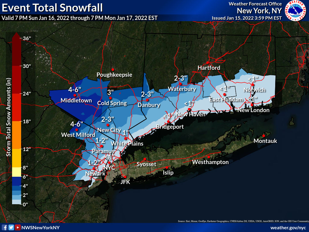
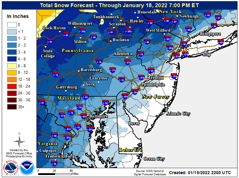
Thanks #s. As for freezing rain, it would hit at a time when people should be off the roads and Monday is a holiday, so hopefully it’s not as big an issue as last time.
As noted above, they have been reliable. Worst gusts between midnight and 3 a.m. Monday a.m., and into the mid 30's early Monday morning.Have the wind gusts, like the snow totals, been toned down too?
Just took a peek at the NWS site for Sunday night and now it says gusts of up to 50mph.
Don't invite me over to ride my bicycle in your area. 😂
I hate hills. Although that's all I do in the winter. Shorter rides (around 25 miles) needs a tougher workout.
Lame.
No surprise that the NWS cut snowfall amounts again, given what the models are showing. The 1" line now essentially runs up 95 and the 3" or more amounts are generally confined to being north of I-80. Likely a fair amount of sleet in locations N of 78 and especially N of 80, and sleet is no picnic either (same mass as snow, just less depth). Hopefully we can avoid much freezing rain as that shit's just nasty, but up to 0.1" is forecast during the transition in the counties with advisories just NW of 95. All the other impacts are still expected, i.e., high winds, coastal flooding, heavy rain/urban flooding. Nice win today by RU...


yep no surprise they keep chopping their overdone amounts as if they dont want to let go, likely to even be chopped again by startime
Are these total snowfall accumulations after storm, or accumulation quickly washed away by rain?
before rain
It's the maximum ever expected to be on the ground at any point in time and in this case, if it's less than 2-3", it'll be mostly washed away by the rain and milder temps. Places that get 4-5" of snow and sleet (with maybe 0.6-0.8" of frozen equivalent) will be able to absorb a fair amount of rain (1/2" at least) on top without that much melting - it gets compacted and can then refreeze when temps go back below 32F on Monday afternoon.Are these total snowfall accumulations after storm, or accumulation quickly washed away by rain?
+2+1
Great job by Bac and Tango!
Super job by Numbers!
For hyping on Wed at 2:40am for a major winter storm that is all but a rain event.+2
Super job by Numbers!
For hyping on Wed at 2:40am for a major winter storm that is all but a rain event.
no hype, just posted all factual info at the times
if you can't tell the difference between "hyping" and sharing the info. that the national weather service is putting out there, then that's on you, not him.For hyping on Wed at 2:40am for a major winter storm that is all but a rain event.
- Status
- Not open for further replies.
Similar threads
- Replies
- 505
- Views
- 23K
- Replies
- 44
- Views
- 2K
- Replies
- 223
- Views
- 9K
ADVERTISEMENT
ADVERTISEMENT