
Yes I did. I can work around flooding. Can't do anything about wind except worry which I am.Did you see the wind chart @Postman_1 shared with us?
Colleges
- American Athletic
- Atlantic Coast
- Big 12
- Big East
- Big Ten
- Colonial
- Conference USA
- Independents (FBS)
- Junior College
- Mountain West
- Northeast
- Pac-12
- Patriot League
- Pioneer League
- Southeastern
- Sun Belt
- Army
- Charlotte
- East Carolina
- Florida Atlantic
- Memphis
- Navy
- North Texas
- Rice
- South Florida
- Temple
- Tulane
- Tulsa
- UAB
- UTSA
- Boston College
- California
- Clemson
- Duke
- Florida State
- Georgia Tech
- Louisville
- Miami (FL)
- North Carolina
- North Carolina State
- Pittsburgh
- Southern Methodist
- Stanford
- Syracuse
- Virginia
- Virginia Tech
- Wake Forest
- Arizona
- Arizona State
- Baylor
- Brigham Young
- Cincinnati
- Colorado
- Houston
- Iowa State
- Kansas
- Kansas State
- Oklahoma State
- TCU
- Texas Tech
- UCF
- Utah
- West Virginia
- Illinois
- Indiana
- Iowa
- Maryland
- Michigan
- Michigan State
- Minnesota
- Nebraska
- Northwestern
- Ohio State
- Oregon
- Penn State
- Purdue
- Rutgers
- UCLA
- USC
- Washington
- Wisconsin
High Schools
- Illinois HS Sports
- Indiana HS Sports
- Iowa HS Sports
- Kansas HS Sports
- Michigan HS Sports
- Minnesota HS Sports
- Missouri HS Sports
- Nebraska HS Sports
- Oklahoma HS Sports
- Texas HS Hoops
- Texas HS Sports
- Wisconsin HS Sports
- Cincinnati HS Sports
- Delaware
- Maryland HS Sports
- New Jersey HS Hoops
- New Jersey HS Sports
- NYC HS Hoops
- Ohio HS Sports
- Pennsylvania HS Sports
- Virginia HS Sports
- West Virginia HS Sports
ADVERTISEMENT
You are using an out of date browser. It may not display this or other websites correctly.
You should upgrade or use an alternative browser.
You should upgrade or use an alternative browser.
OT: Winter Storm Likely to Impact Our Area 1/16-17
- Thread starter RU848789
- Start date
- Status
- Not open for further replies.
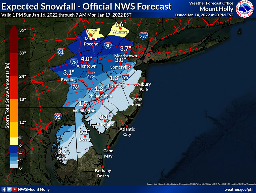
Here are the NWS discussions for the Philly/NYC areas of the tidal flooding issue. An advisory will surely be issued tomorrow after the current one expires tomorrow.Thankfully this isn't the highest lunar tide of the month, that comes in 2 weeks but with the current projections are all over the place it may not matter. Going to have to watch closely around here.
Area Forecast Discussion
National Weather Service Mount Holly NJ
357 PM EST Fri Jan 14 2022
TIDES/COASTAL FLOODING...
A full moon occurs on Monday. While the astronomical tides
associated with this full moon are not particularly high, it will
nonetheless contribute to the potential for coastal flooding over
the next few days.
There are currently two periods of concern for coastal flooding. The
first is in association with the high tide occurring early Saturday
morning. A large offshore storm system, unrelated to the storm
moving in this weekend, is causing elevated water levels along the
coast. It now appears that water levels will become sufficiently
high to lead to a round of widespread minor flooding at the Atlantic
coast with that early Saturday morning high tide. As a result, a
Coastal Flood Advisory has been issued for the Atlantic coasts of
New Jersey and Delaware, with the exception of Middlesex County in
New Jersey.
Water levels will decline after the Saturday morning high tide
cycle. The next period of concern will be with the Monday morning
high tide as the next storm system moves through the region. Onshore
flow will develop on Sunday, and strengthen by Sunday night. By
later Sunday night, easterly winds will become strong, with gusts of
40 to 50 mph possible at the coast. This could cause a concentrated
surge of water to develop during the late Sunday night period. If
this surge were to correspond to the timing of high tide, at least
moderate coastal flooding would be possible. Currently, the areas of
greatest concern for this would be northern New Jersey coastal areas
such as the Monmouth County coast and Raritan Bay, where the surge
will arrive latest and closer to the time of high tide. Further
south, the surge will arrive earlier and will more likely peak
closer to low tide, keeping flooding no worse than minor. Due to the
forecast uncertainty, users are encouraged to continue monitoring
the forecast for the Monday morning high tide.
Water levels should quickly diminish by later Monday, with no
further coastal flooding expected.
Area Forecast Discussion
National Weather Service New York NY
517 PM EST Fri Jan 14 2022
.TIDES/COASTAL FLOODING...
With an upcoming storm system moving up from the south late in the
weekend and with the approach of a full moon, there will be
increasing potential for coastal flooding during and around times of
high tide Sunday night and Monday during the day. The Monday daytime
coastal flooding looks to be potentially worse and quite widespread
with the possibility of moderate coastal flooding. This is all
contingent on the precise track of the low which more models are
depicting to pass near, but just west of the waters.
Sunday night looks to be confined to the typically more vulnerable
locations across the South Shore Bays and some other coastlines with
more of a depiction towards minor coastal flooding. It is the next
high tide cycle that will pose a higher threat as winds really
substantially increase out of the E-SE Sunday night into early
Monday adding to the surge component, effectively piling more water
along the coastlines. Ekman transport will also result in higher
water levels along coastline. Forecast surge of 2 to 4 feet early
Monday will allow for this widespread coastal flooding, of which
quite a few locations especially the South Shore Bays, lower NY
Harbor and Western Long Island Sound shorelines could get moderate
coastal flooding. This coastal flood threat is highlighted in the
HWO for all of the coastal zones.
Also, another feature that will be another potential coastal hazard
will be the potentially strong winds, high surf that would result
erosion along the ocean beaches. Forecast ocean seas get to 10 to 15
ft late Sunday night through Monday.
Admit it, you miss Amy Freeze ever since she left ABC NY. She was the Dean and the Queen of local weather personalities.News12, who I've never been a big fan of, has a goofy snowfall map, with 1-2" for the 95 corridor, with the 1" line being from about Glassboro to Sandy Hook and the 2" line being from about Frenchtown to Nyack, and 3-6" NW of the 2" line - that's just sloppy work, since that's discontinuous. Either needs to be 1-2"/2-6" or 1-3"/3-6" for continuity or add a 2-3" swath.
Hey, maybe it's time for a visit from @RUJohnny...

FWIW that site does seem to be, shall we say, more robust than others. Hopefully it's overstating.Did you see the wind chart @Postman_1 shared with us?
Admit it, you miss Amy Freeze ever since she left ABC NY. She was the Dean and the Queen of local weather personalities.
she is on Fox now
That's what I'm thinking. May have to get up at 5am Monday (high tide is 7:10 or so) and go into town, get a cup of coffee and wait it out if the projections worsen.Here are the NWS discussions for the Philly/NYC areas of the tidal flooding issue. An advisory will surely be issued tomorrow after the current one expires tomorrow.
Area Forecast Discussion
National Weather Service Mount Holly NJ
357 PM EST Fri Jan 14 2022
TIDES/COASTAL FLOODING...
A full moon occurs on Monday. While the astronomical tides
associated with this full moon are not particularly high, it will
nonetheless contribute to the potential for coastal flooding over
the next few days.
There are currently two periods of concern for coastal flooding. The
first is in association with the high tide occurring early Saturday
morning. A large offshore storm system, unrelated to the storm
moving in this weekend, is causing elevated water levels along the
coast. It now appears that water levels will become sufficiently
high to lead to a round of widespread minor flooding at the Atlantic
coast with that early Saturday morning high tide. As a result, a
Coastal Flood Advisory has been issued for the Atlantic coasts of
New Jersey and Delaware, with the exception of Middlesex County in
New Jersey.
Water levels will decline after the Saturday morning high tide
cycle. The next period of concern will be with the Monday morning
high tide as the next storm system moves through the region. Onshore
flow will develop on Sunday, and strengthen by Sunday night. By
later Sunday night, easterly winds will become strong, with gusts of
40 to 50 mph possible at the coast. This could cause a concentrated
surge of water to develop during the late Sunday night period. If
this surge were to correspond to the timing of high tide, at least
moderate coastal flooding would be possible. Currently, the areas of
greatest concern for this would be northern New Jersey coastal areas
such as the Monmouth County coast and Raritan Bay, where the surge
will arrive latest and closer to the time of high tide. Further
south, the surge will arrive earlier and will more likely peak
closer to low tide, keeping flooding no worse than minor. Due to the
forecast uncertainty, users are encouraged to continue monitoring
the forecast for the Monday morning high tide.
Water levels should quickly diminish by later Monday, with no
further coastal flooding expected.
Area Forecast Discussion
National Weather Service New York NY
517 PM EST Fri Jan 14 2022
.TIDES/COASTAL FLOODING...
With an upcoming storm system moving up from the south late in the
weekend and with the approach of a full moon, there will be
increasing potential for coastal flooding during and around times of
high tide Sunday night and Monday during the day. The Monday daytime
coastal flooding looks to be potentially worse and quite widespread
with the possibility of moderate coastal flooding. This is all
contingent on the precise track of the low which more models are
depicting to pass near, but just west of the waters.
Sunday night looks to be confined to the typically more vulnerable
locations across the South Shore Bays and some other coastlines with
more of a depiction towards minor coastal flooding. It is the next
high tide cycle that will pose a higher threat as winds really
substantially increase out of the E-SE Sunday night into early
Monday adding to the surge component, effectively piling more water
along the coastlines. Ekman transport will also result in higher
water levels along coastline. Forecast surge of 2 to 4 feet early
Monday will allow for this widespread coastal flooding, of which
quite a few locations especially the South Shore Bays, lower NY
Harbor and Western Long Island Sound shorelines could get moderate
coastal flooding. This coastal flood threat is highlighted in the
HWO for all of the coastal zones.
Also, another feature that will be another potential coastal hazard
will be the potentially strong winds, high surf that would result
erosion along the ocean beaches. Forecast ocean seas get to 10 to 15
ft late Sunday night through Monday.
FWIW that site does seem to be, shall we say, more robust than others. Hopefully it's overstating.

Amy Freeze Wardrobe Malfunction
Here are 15 shocking wardrobe malfunctions you never noticed in huge. Amy turner accepted a dare to jump into the swimming pool wearing her...
 modernallfurniture.blogspot.com
So you are trying to say more people will be impacted by the snow then the cold? That area is maybe 1% of the population of NYC, Central and South Jersey, Philadelphia. Seriously??Most forecasters have the Lehigh Valley, NWNJ (Warren/Sussex/Morris/Passaic) and the Hudson Valley getting at least several inches of snow and sleet and perhaps not much rain (which may just be absorbed in the snow/sleet pack, not washing away), so it's not just the Poconos - and these people are interested in that forecast, as there will be travel/removal impacts.
Also, the forecast lows in Philly are 11 and 13 the next two nights, which is slightly colder than the last 2 year's coldest, but 7 of the previous 9 years saw single digit lows which were colder and 80 of the last 100 years saw temps in the single digits, so 11 and 13 aren't that unusual. Plus, the only places with wind chill advisories are the Poconos and Sussex and Philly is pretty far from conditions for an advisory. Yeah it's cold, but most barely give that a 2nd thought unless they work outside or are one of the few unfortunate enough to lose heat - but far more lose power/heat from wind/snow than cold.
5 January 31, 2019 -15 4 January 07, 2018 -16 9 December 31, 2017 -13 8 February 14, 2016 -13 2 February 20, 2015 -17 4 January 22, 2014 + -16 12 January 23, 2013 -11 14 January 04, 2012 -10 8 January 24, 2011 -13
Your snow bias keeps showing up.
If you believe that no one cares about cold weather why did you post the trend thread??? You can't have it both ways. Also look at daytime highs. It's been years since we will hit these numbers tomorrow.
Also why did you feel the need to call me out on this. I didn't respond to any of your posts on this thread. Why don't you rip Tango a new ass?? I was responding to his post. You cry like a baby when you think someone "trolls" you. How about stop trolling me for a change. Your bias for snow over bad weather maybe a reason people troll you. You give a one sided narrow approach.
Amy Freeze Wardrobe Malfunction
Here are 15 shocking wardrobe malfunctions you never noticed in huge. Amy turner accepted a dare to jump into the swimming pool wearing her...
Definitely don't click on that link.
Not missed at all, sorry - couldn't hold a candle to actual meteorologists, like Lee Goldberg and Jeff Smith...Admit it, you miss Amy Freeze ever since she left ABC NY. She was the Dean and the Queen of local weather personalities.
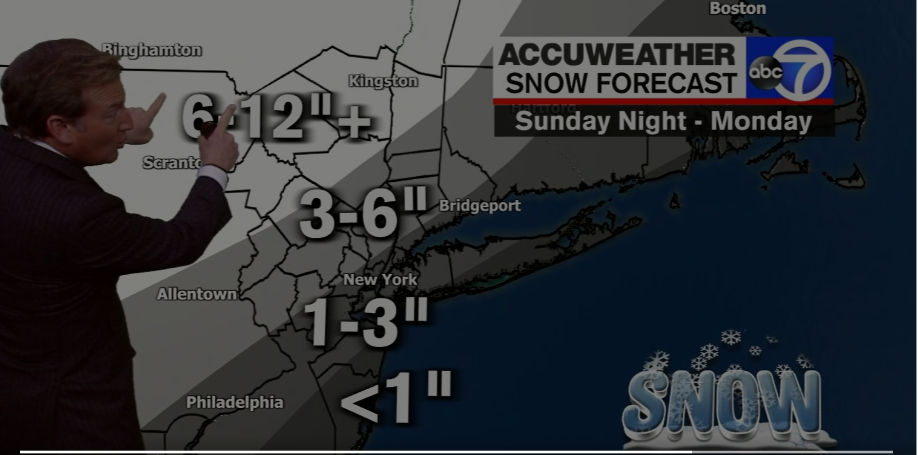
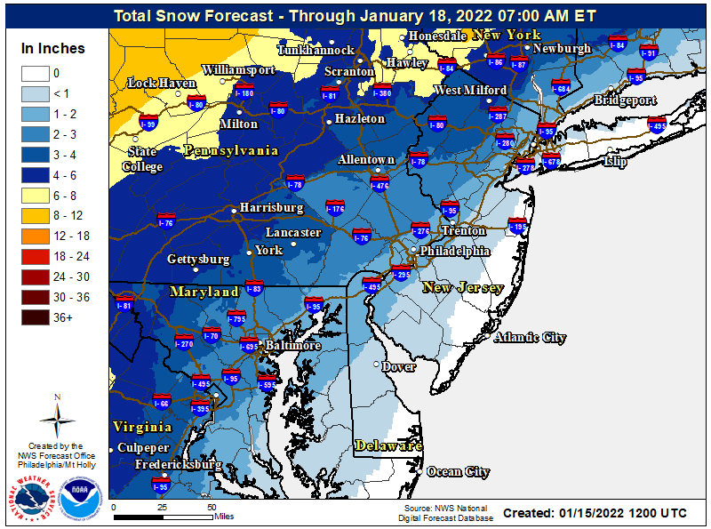
Lee Goldberg put up a preliminary snowfall map with about a 30 mile wide 1-3" swath centered on the 95 corridor from Philly to NYC (with the center essentially being a direct line from Center City to Central Park). The 1" line runs from about Glassboro to to Keansburg to Uniondale (with <1" SE of that line), while the 3" line runs from about King of Prussia to Somerville to White Plains. There is then a 3-6" swath with the 6" line running from about Northampton to Newton to Poughkeepsie and 6-12" NW of that line.
Unfortunately, they haven't put the map up in the latest broadcast on line. Seems reasonable, although maybe a bit too optimistic for the 95 corridor, especially the 1" line being that far SE - could see that being more like right along 95. The good thing, so far, is not too much mention of freezing rain by the NWS or other pros, especially for the 95 corridor.
Edit: map now up. Also, keep in mind that with a general 1" of liquid equivalent falling, that means to get the amount of rain roughly expected, subtract out the snow (at 1" snow per 0.1" liquid), so for someone getting 3" of snow, they're likely going to then get 0.7" of rain (unless they get appreciable sleet too).
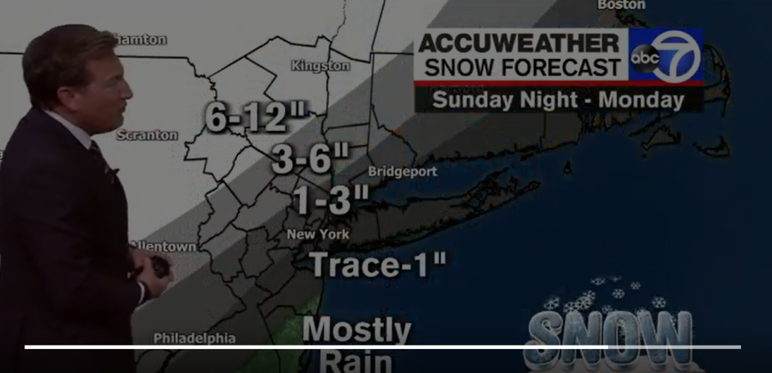
First change in Lee's map since yesterday, as he has moved the snow field to the NW, which makes sense to me, as I think he and the NWS were being a bit too bullish on snowfall, especially along 95, as I've posted. The 1" "line" was moved about 15 miles NW, roughly, with 95 now being the 1" line instead of the center of the 1-3" swath. The 3" line was moved maybe 10 miles NW, whild the 6" likne wasn't really moved at all.
Admit it, you miss Amy Freeze ever since she left ABC NY. She was the Dean and the Queen of local weather personalities.
I think @Knight Shift covered himself well with his post. I knew what he meant.Not missed at all, sorry - couldn't hold a candle to actual meteorologists, like Lee Goldberg and Jeff Smith...
I am a big Janice Huff fan myself.
NWS just posted Coastal Flood Advisory for the entire Jersey Coast for tomorrow and Monday morning high tides. Right now they're predicting minor flooding both cycles but I could see a change for Monday. The wind will be a big determining factor
Why so angry? I simply provided more info about your somewhat erroneous post (it's not going to be that cold in Philly) and said it's going to be a lot more than a rainstorm for many. I showed you how 11/13F were well above record lows for most years and now you're saying it's been years since we'll hit the temps for tomorrow's forecast high of 25F, which is way off. The record low high temp for the date is 17F (1994) and it's been well below 25F numerous times over the past several years, so while 25F is cold, it's not remarkably cold. As recently as 2018 and 2019 Philly had record low high temps in January that were in the upper teens. Also, while 11/13F are pretty cold, they're also pretty far off the record cold temp for 1/15 of 3F.So you are trying to say more people will be impacted by the snow then the cold? That area is maybe 1% of the population of NYC, Central and South Jersey, Philadelphia. Seriously??
Your snow bias keeps showing up.
If you believe that no one cares about cold weather why did you post the trend thread??? You can't have it both ways. Also look at daytime highs. It's been years since we will hit these numbers tomorrow.
Also why did you feel the need to call me out on this. I didn't respond to any of your posts on this thread. Why don't you rip Tango a new ass?? I was responding to his post. You cry like a baby when you think someone "trolls" you. How about stop trolling me for a change. Your bias for snow over bad weather maybe a reason people troll you. You give a one sided narrow approach.
Maybe don't make claims off the top of your head and we'll have less to argue about. And I didn't respond to Tango, since he simply posted info about how cold it would be, which I have zero issue with - like you said, I started a thread about a likely cold and snowy pattern, as I'm interested in both. I responded to you, since you said, "It's actually the bigger story of the next 3 days. Who cares about a rain storm?" which I disagree with, as I stated. Sorry, but I just don't think the vast majority of people care much about a day that'll be cold, but nowhere near record cold, vs. the potential for significant wintry precip (inland), heavy rains/urban flooding, high winds and coastal flooding. I'll be playing disc golf outside tomorrow from 9 am until about 1 pm and have zero concerns about being outside in it. But it's certainly an issue for people who need to work outside all day, as I have stated.
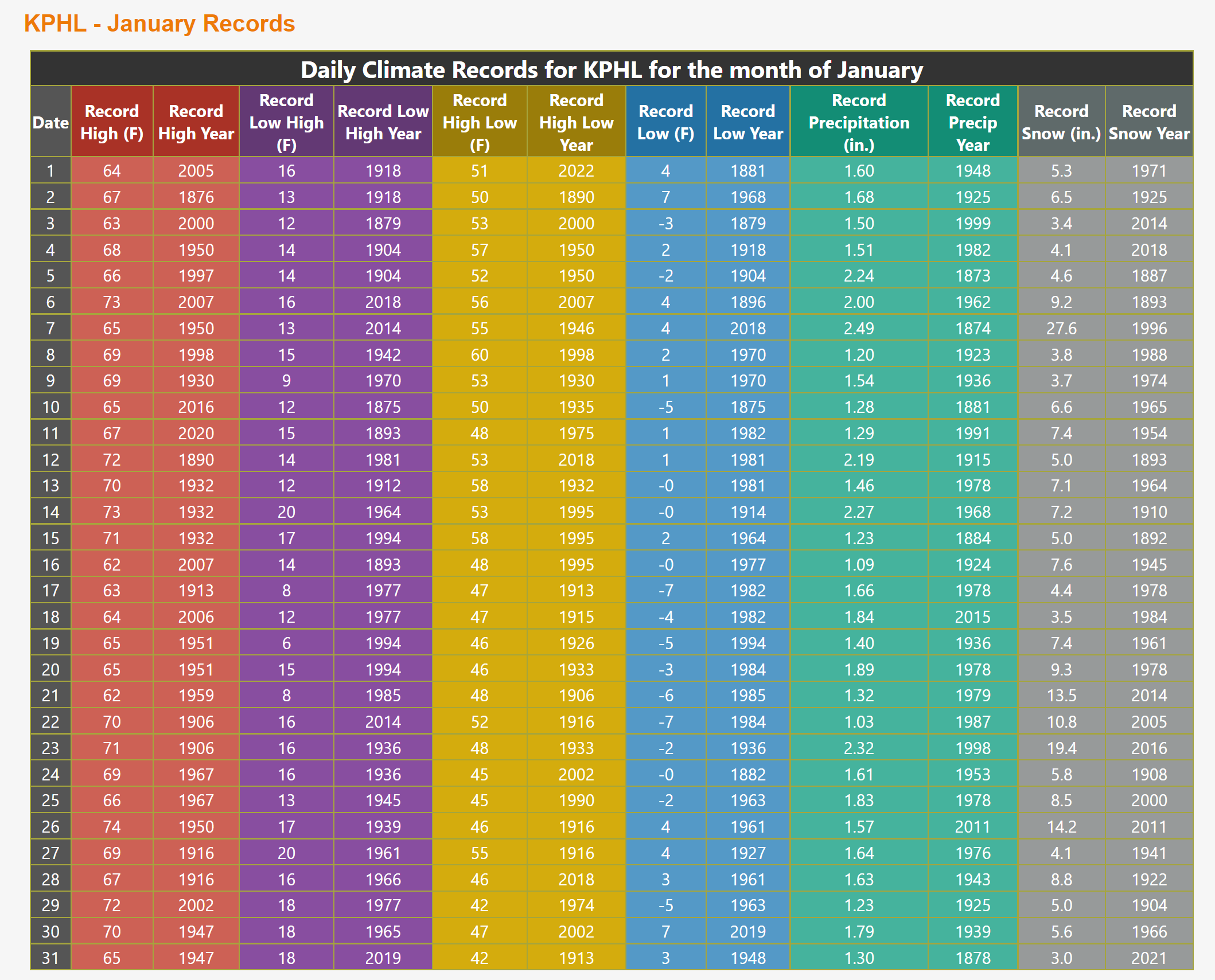
https://www.weather.gov/phi/clirecordsKPHL
Actually, the advisory is only for tomorrow morning, but they'll almost certainly issue an advisory after tomorrow's expires, for Sunday night/Monday, as per their discussion (posted above). Personally, I think the NWS-Philly should've issued a coastal flood watch for NJ/DE for Sunday/Monday, like the NWS-NYC did for their coastal counties today. The advisory is for imminent concerns, like tomorrow, while watches are better for concerns that are 24+ hours in the future - just like winter storm watches, they then get converted to warnings or advisories, when the threat is imminent.NWS just posted Coastal Flood Advisory for the entire Jersey Coast for tomorrow and Monday morning high tides. Right now they're predicting minor flooding both cycles but I could see a change for Monday. The wind will be a big determining factor
https://forecast.weather.gov/wwamap/wwatxtget.php?cwa=phi&wwa=coastal flood advisory
https://forecast.weather.gov/wwamap/wwatxtget.php?cwa=phi&wwa=coastal flood watch
I think I recall you saying your street in Mansquan floods when there is "minor" coastal flooding - does it get bad enough to impact driving? Any concerns for your house or property? How about if there's "moderate" flooding? Good luck - we have friends in Manasquan, but they're at a high enough elevation to not usually be affected.That's what I'm thinking. May have to get up at 5am Monday (high tide is 7:10 or so) and go into town, get a cup of coffee and wait it out if the projections worsen.
First of all you didn't answer my question. Why did your troll me today and not call out Tango? Oh I forget you are getting banned from threads.Why so angry? I simply provided more info about your somewhat erroneous post (it's not going to be that cold in Philly) and said it's going to be a lot more than a rainstorm for many. I showed you how 11/13F were well above record lows for most years and now you're saying it's been years since we'll hit the temps for tomorrow's forecast high of 25F, which is way off. The record low high temp for the date is 17F (1994) and it's been well below 25F numerous times over the past several years, so while 25F is cold, it's not remarkably cold. As recently as 2018 and 2019 Philly had record low high temps in January that were in the upper teens. Also, while 11/13F are pretty cold, they're also pretty far off the record cold temp for 1/15 of 3F.
Maybe don't make claims off the top of your head and we'll have less to argue about. And I didn't respond to Tango, since he simply posted info about how cold it would be, which I have zero issue with - like you said, I started a thread about a likely cold and snowy pattern, as I'm interested in both. I responded to you, since you said, "It's actually the bigger story of the next 3 days. Who cares about a rain storm?" which I disagree with, as I stated. Sorry, but I just don't think the vast majority of people care much about a day that'll be cold, but nowhere near record cold, vs. the potential for significant wintry precip (inland), heavy rains/urban flooding, high winds and coastal flooding. I'll be playing disc golf outside tomorrow from 9 am until about 1 pm and have zero concerns about being outside in it. But it's certainly an issue for people who need to work outside all day, as I have stated.
https://www.weather.gov/phi/clirecordsKPHL
Second you act like I troll you. Admit you trolled me today.
Your record high post is wrong. All three TV stations in Philadelphia dispute your nonsense. I'm make claims off of facts, you make claims off of wish-casting. And you suck at it.
And again if people don't care about the cold why did you start a thread about the cold trend?? And then defend it. You are such a two face clown
Is the second half of January still going to be colder and snowier than usual?
Have a surgery coming up unfortunately and ain’t no one got time for that snow jibba jabba.
Have a surgery coming up unfortunately and ain’t no one got time for that snow jibba jabba.
Well, you never know there might be some jibber jabber instead.Is the second half of January going to be colder and snowier than usual?
Have a surgery coming up unfortunately and ain’t no one got time for that snow jibba jabba.
First of all you didn't answer my question. Why did your troll me today and not call out Tango? Oh I forget you are getting banned from threads.
Second you act like I troll you. Admit you trolled me today.
Your record high post is wrong. All three TV stations in Philadelphia dispute your nonsense. I'm make claims off of facts, you make claims off of wish-casting. And you suck at it.
And again if people don't care about the cold why did you start a thread about the cold trend?? And then defend it. You are such a two face clown
if you think he sucks at forecasting please don’t click on his links.
This childish back and forth is ruining a good conversation
lol, you're arguing that something you "heard on TV" (which is kind of hard to verify) is more accurate than what I linked to from the NWS - now that's funny - since you appear to be unable to click on and read a link, I saved you the effort and pasted the relevant daily climate records for Philly in January for you, below. It clearly shows the record low of 2F and record low high of 17F for Jan 15th - given those numbers, I low of 11F and a high of 25F don't seem so remarkably cold, do they? Or do you think the NWS is part of my conspiracy?First of all you didn't answer my question. Why did your troll me today and not call out Tango? Oh I forget you are getting banned from threads.
Second you act like I troll you. Admit you trolled me today.
Your record high post is wrong. All three TV stations in Philadelphia dispute your nonsense. I'm make claims off of facts, you make claims off of wish-casting. And you suck at it.
And again if people don't care about the cold why did you start a thread about the cold trend?? And then defend it. You are such a two face clown
Also, you don't even read what I write that you respond to so angrily. Please look at my previous post, where I explained why I didn't say anything to Tango, but did respond to you and why. This is how you tie yourself up in illogical knots. I didn't troll you today, I simply disagreed with you and corrected your erroneous posts - there's a big difference.
I actually was talking to Tango. Look at the thread. The child is #s cutting into a conversation that he wasn't involved in. And the funny thing he says he doesn't forecast. The child is #s. The post against me was started by him. You clowns defend him but don't actually read how they become childish. It's always numbers who starts crapif you think he sucks at forecasting please don’t click on his links.
This childish back and forth is ruining a good conversation
Yes, it will certainly be colder than normal - that's far easier to predict, as I said in the pattern thread. But whether or not it will be snowier is an open question. This storm on Sunday was the first chance at snow in the 2nd half of Jan and it's going to be snowy well inland, but not for the 95 corridor - near miss. Beyond this storm there are a few possibilities on the long range models, but nothing that jumps out as a serious threat - but then again anything beyond 6-7 days is way too soon to talk about anyway.Is the second half of January still going to be colder and snowier than usual?
Have a surgery coming up unfortunately and ain’t no one got time for that snow jibba jabba.
These are the facts.lol, you're arguing that something you "heard on TV" (which is kind of hard to verify) is more accurate than what I linked to from the NWS - now that's funny - since you appear to be unable to click on and read a link, I saved you the effort and pasted the relevant daily climate records for Philly in January for you, below. It clearly shows the record low of 2F and record low high of 17F for Jan 15th - given those numbers, I low of 11F and a high of 25F don't seem so remarkably cold, do they? Or do you think the NWS is part of my conspiracy?
Also, you don't even read what I write that you respond to so angrily. Please look at my previous post, where I explained why I didn't say anything to Tango, but did respond to you and why. This is how you tie yourself up in illogical knots. I didn't troll you today, I simply disagreed with you and corrected your erroneous posts - there's a big difference.
You trolled me.
More people will be impacted by the cold tomorrow than snow Monday. The dumbest post on here is you disputing that. 12 million people will get a rain event .
You are afraid to get banned again. Have complained this week multiple times about that.
Still haven't admitted you trolled me today. I wasn't posting anything about you. Laughable you still complain about trolls but won't admit you trolled me
Thank you for the insight and reply. Personally, cold is fine. Just hoping to avoid any major snowstorms selfishly before month end or so.Yes, it will certainly be colder than normal - that's far easier to predict, as I said in the pattern thread. But whether or not it will be snowier is an open question. This storm on Sunday was the first chance at snow in the 2nd half of Jan and it's going to be snowy well inland, but not for the 95 corridor - near miss. Beyond this storm there are a few possibilities on the long range models, but nothing that jumps out as a serious threat - but then again anything beyond 6-7 days is way too soon to talk about anyway.
Read the whole thread. Never did I even talk or quote him. Maybe you should read it from start to finish and figure out who the child is. Certainly not meif you think he sucks at forecasting please don’t click on his links.
This childish back and forth is ruining a good conversation
No , my street is one of the last to flood on the beach side. What happens is the streets around me often flood just because of regular lunar tides which leaves only 1 way off the beach (Ocean Ave) as long as that stays clear. The thing you don't want to do if at all possible is drive thru even an inch or two of salt water.I think I recall you saying your street in Mansquan floods when there is "minor" coastal flooding - does it get bad enough to impact driving? Any concerns for your house or property? How about if there's "moderate" flooding? Good luck - we have friends in Manasquan, but they're at a high enough elevation to not usually be affected.
My first floor is 8.5' off the ground since being lifted in '17-'18 so that's not a concern when you consider Irene was 18" above ground level and Sandy a bit over 5' but thanks.
ok, thanks for clarifying and great to hear you're at a height that should be safe for a long, long time...No , my street is one of the last to flood on the beach side. What happens is the streets around me often flood just because of regular lunar tides which leaves only 1 way off the beach (Ocean Ave) as long as that stays clear. The thing you don't want to do if at all possible is drive thru even an inch or two of salt water.
My first floor is 8.5' off the ground since being lifted in '17-'18 so that's not a concern when you consider Irene was 18" above ground level and Sandy a bit over 5' but thanks.
I actually had discontinuous totals for two storms ago, I really used the ranges to Try to drive home the idea that it'd be an extreme gradient.News12, who I've never been a big fan of, has a goofy snowfall map, with 1-2" for the 95 corridor, with the 1" line being from about Glassboro to Sandy Hook and the 2" line being from about Frenchtown to Nyack, and 3-6" NW of the 2" line - that's just sloppy work, since that's discontinuous. Either needs to be 1-2"/2-6" or 1-3"/3-6" for continuity or add a 2-3" swath.
Hey, maybe it's time for a visit from @RUJohnny...
This one looks boring to me. Some snow after everyones home for the night watching playoff football and most of it washed away by the time everyone wakes up Monday. I'll give some more comment if warranted tomorrow.
Huh, it seems like Fox gets all the nitwits.she is on Fox now
As an engineer, it's like fingernails on a blackboard for me, since snowfall is simply not a discontinuous variable, although I get your psychological point. Yeah, it's not looking like any surprises are in store, as the models have been pretty locked in for awhile now.I actually had discontinuous totals for two storms ago, I really used the ranges to Try to drive home the idea that it'd be an extreme gradient.
This one looks boring to me. Some snow after everyones home for the night watching playoff football and most of it washed away by the time everyone wakes up Monday. I'll give some more comment if warranted tomorrow.
I love the part about people who live in Florida!
You come off as a miserable f*ck in almost every post you make. Give it restFirst of all you didn't answer my question. Why did your troll me today and not call out Tango? Oh I forget you are getting banned from threads.
Second you act like I troll you. Admit you trolled me today.
Your record high post is wrong. All three TV stations in Philadelphia dispute your nonsense. I'm make claims off of facts, you make claims off of wish-casting. And you suck at it.
And again if people don't care about the cold why did you start a thread about the cold trend?? And then defend it. You are such a two face clown
NWS:
Good Morning Everyone! The latest briefing package has been updated at https://www.weather.gov/media/phi/current_briefing.pdf (note: you may need to refresh the page and/or clear your cache to see the latest version). There remains the potential for impacts due to winds, coastal/tidal flooding, and wintry precipitation. Please see the briefing package for full details.
Good Morning Everyone! The latest briefing package has been updated at https://www.weather.gov/media/phi/current_briefing.pdf (note: you may need to refresh the page and/or clear your cache to see the latest version). There remains the potential for impacts due to winds, coastal/tidal flooding, and wintry precipitation. Please see the briefing package for full details.
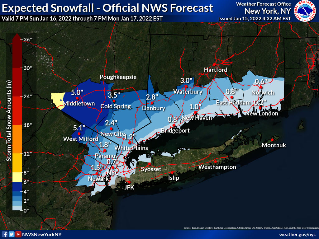
12Z models are pretty similar to the 0Z models, so not much change in the NWS snowfall maps, other than the Philly office bumping up snowfall amounts well NW (Sussex/Poconos) to match what NWS-NYC has for Orange/Passaic counties - and keep in mind those numbers could be a fair amount less if sleet comes earlier as some think will occur (as per the NAM), although sleet is just as impactful on roads and for removal as snow (but not a visibility issue).
Because of the increases, the NWS issued winter storm watches for Sussex and Carbon/Monroe (Poconos) for 5-7" of snow/sleet (and possibly freezing rain accumulations of 0.1"). A bit surprised the NWS didn't cut back snow for the 95 corridor, but their thinking is it's going to still be pretty cold at the start so a few hours of snow could easily get 1-3" before the deluge.
All the other threats are still there too: coastal flooding being minor to moderate with the astronomical high tide, high winds (up to 60 mph gusts near the coast), which could cause power outages, and heavy rains leading to localized urban flooding (1" or more where it's mostly rain).
https://forecast.weather.gov/produc...&format=CI&version=1&glossary=1&highlight=off
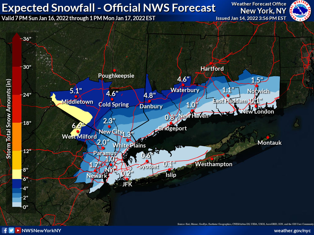
The NWS-NYC updated theirsnowfall map this morning and it shows a bit less snow for everyone, mostly due to more warm air advection aloft, leading to more sleet. The NWS-Philly has said they've also cut back snowfall amounts for the same reason, but haven't yet updated their snowfall map for some reason, but the NWS Eastern Region map has updated and is also below. Precip will likely start in the early evening as snow for most and then quickly change over to sleet, then rain through the 95 corridor and even a bit inland and go into Monday morning; the changeover will be overnight well N/W of 95. And if the NAM/RDPS (RGEM) are right (and they often do well in these setups), snowfall numbers everywhere, even into central PA/NY will be much less than shown in other models, due to this warm air at 850 mbar (~5000 feet up) leading to much more sleet - still a wintry event with the same frozen mass, but not as much snow.
For the 95 corridor and just NW of 95, and the coast, especially, the main story will be the heavy rainfall (1-1.5") possibly causing localized urban flooding and the strong winds late Sunday/early Monday which will gust to 40-50 mph and near 60 mph at the coast, possibly leading to some power outages - a wind advisory will likely be issues soon. In addition there is a coastal flood watch up for Monmouth/Middlesex, NENJ, NYC and LI/CT for minor to possible moderate flooding, especially with Monday morning's high tide, as per the link below.
Temps bottomed out in the low/mid teens along and SE of the 95 corridor this morning (11F in NB and 16F in Philly) and in the single digits NW of 95, with the wind chill advisory still being up for the Poconos/Sussex for wind chills of -10 to -20F this morning. Temps will likely be a couple of degrees colder Sunday morning.
https://forecast.weather.gov/wwamap/wwatxtget.php?cwa=phi&wwa=coastal flood watch
https://www.weather.gov/phi/
- Status
- Not open for further replies.
Similar threads
- Replies
- 505
- Views
- 23K
- Replies
- 44
- Views
- 2K
ADVERTISEMENT
ADVERTISEMENT