
Saturday's game is our group's annual get together. I'm up from NC. Another from GA. One from PA. Two from North Jersey. Sunday the gang heads off to hike the Connecticut section of the Appalachian Trail. Looking like cool and showery for that. But we rented a lake house for the week, so no tenting. Thankfully.
Colleges
- American Athletic
- Atlantic Coast
- Big 12
- Big East
- Big Ten
- Colonial
- Conference USA
- Independents (FBS)
- Junior College
- Mountain West
- Northeast
- Pac-12
- Patriot League
- Pioneer League
- Southeastern
- Sun Belt
- Army
- Charlotte
- East Carolina
- Florida Atlantic
- Memphis
- Navy
- North Texas
- Rice
- South Florida
- Temple
- Tulane
- Tulsa
- UAB
- UTSA
- Boston College
- California
- Clemson
- Duke
- Florida State
- Georgia Tech
- Louisville
- Miami (FL)
- North Carolina
- North Carolina State
- Pittsburgh
- Southern Methodist
- Stanford
- Syracuse
- Virginia
- Virginia Tech
- Wake Forest
- Arizona
- Arizona State
- Baylor
- Brigham Young
- Cincinnati
- Colorado
- Houston
- Iowa State
- Kansas
- Kansas State
- Oklahoma State
- TCU
- Texas Tech
- UCF
- Utah
- West Virginia
- Illinois
- Indiana
- Iowa
- Maryland
- Michigan
- Michigan State
- Minnesota
- Nebraska
- Northwestern
- Ohio State
- Oregon
- Penn State
- Purdue
- Rutgers
- UCLA
- USC
- Washington
- Wisconsin
High Schools
- Illinois HS Sports
- Indiana HS Sports
- Iowa HS Sports
- Kansas HS Sports
- Michigan HS Sports
- Minnesota HS Sports
- Missouri HS Sports
- Nebraska HS Sports
- Oklahoma HS Sports
- Texas HS Hoops
- Texas HS Sports
- Wisconsin HS Sports
- Cincinnati HS Sports
- Delaware
- Maryland HS Sports
- New Jersey HS Hoops
- New Jersey HS Sports
- NYC HS Hoops
- Ohio HS Sports
- Pennsylvania HS Sports
- Virginia HS Sports
- West Virginia HS Sports
ADVERTISEMENT
You are using an out of date browser. It may not display this or other websites correctly.
You should upgrade or use an alternative browser.
You should upgrade or use an alternative browser.
Weather for MSU @ RU: some light showers likely for tailgates (<0.1") and steadier rain for the game (0.1-0.25")
- Thread starter RU848789
- Start date

Hoping it is dry through 2pm... will be hard to convince gf to go...
Once there I can say weather was supposed to be good through 5pm and say I am sorry
Once there I can say weather was supposed to be good through 5pm and say I am sorry
"You know what they say....no rain, no pain!"Hoping it is dry through 2pm... will be hard to convince gf to go...
Once there I can say weather was supposed to be good through 5pm and say I am sorry
Sunday actually looks mostly dry with some sunshine and just a chance of a few showers in the AT section of CT.Saturday's game is our group's annual get together. I'm up from NC. Another from GA. One from PA. Two from North Jersey. Sunday the gang heads off to hike the Connecticut section of the Appalachian Trail. Looking like cool and showery for that. But we rented a lake house for the week, so no tenting. Thankfully.
There's that, plus there was supposed to be an upper level low phasing to some extent with the coastal low, slowing it and drawing it more northward, but that's now unlikely to happen, allowing the coastal low to stay further south, meaning likely less rain for our area on Saturday and little rain for our area on Sunday. DT/WxRisk does a nice job of explaining this in detail in the link below...Talk about how the blocking is keeping this development more south. The NAM gives us a glimmer of hope we can thread the needle
Thanks. Sunday is travel/move in day. Hiking begins Monday and concludes next Saturday, by noon, in time for RU v Indiana, at a watering hole in Great Barrington MA.Sunday actually looks mostly dry with some sunshine and just a chance of a few showers in the AT section of CT.
C'mon, we are playing the team formerly coached by a guy who ADMITTED to the world he masturbated on the phone with the consultant hired to teach his players about accountability to women. How about:Uhm.....how about we go with something NOT about masturbation???
(and if you say "It's Raining Men" we're gonna have a problem buddy!!!!)
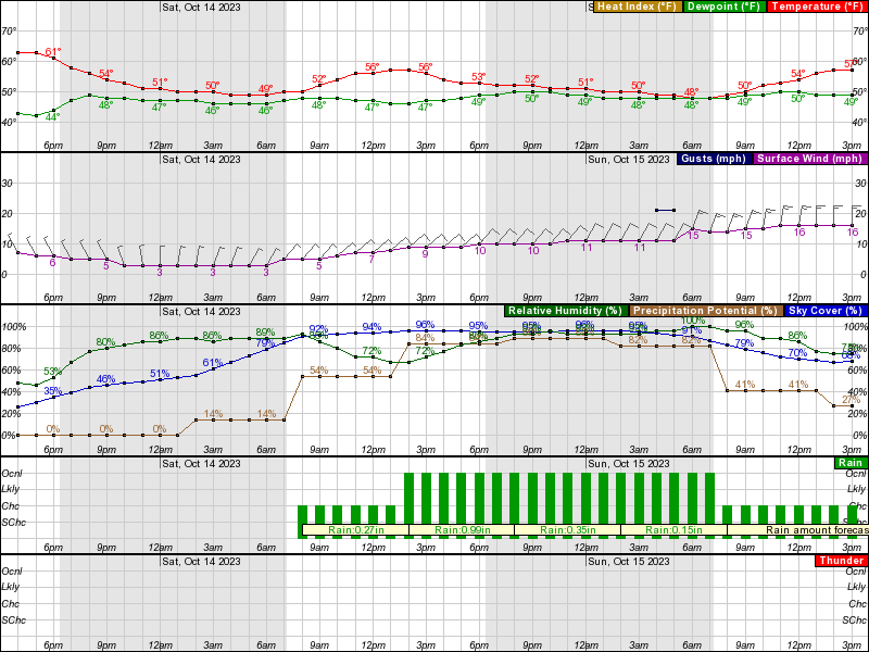
And not a huge change in today's 12Z models, plus we now have precip amounts being forecast by the NWS for Saturday, as we get closer to the event (see the graphic below) Best guess is still about 0.1" of rain from sunrise through about noon, with most of that time being dry, although 0.1" is enough to want to have a canopy for a tailgate, followed by about 0.1-0.25" during the game with the rain being light to moderate and falling most of the time, especially in the 2nd half (but heavy downpours are unlikely). It is still possible that the tailgates are completely dry, but I wouldn't bet that way, although on the plus side, the chances of heavy, flooding rains have gone signifcantly down, so I'd be suprised to see more than 0.3-0.4" of rain during the game.
Temps will be in the low 50s in the morning with highs only making it into the mid-50s in the afternoon; fortunately, winds will be tolerable (~10 mph) through the game, with much windier and rainier conditions holding off until the late afternoon/evening. For those interested, the significant rain looks to be mostly over by sunrise on Sunday, as the coastal low looks to head more out to sea than up the coast, with only some light to moderate showers in the morning (<1/4") and mostly dry in the afternoon with maybe a few passing showers.
https://forecast.weather.gov/MapClick.php?lon=-74.45695963735406&lat=40.52715685114464
SHORT TERM /THURSDAY NIGHT THROUGH SATURDAY NIGHT/...
High pressure ridges in from the north and west Thursday night
through Friday, helping keep the forecast dry to finish the work
week. Expect low temps in the 40s to low 50s at night and highs in
the mid to upper 60s with mid 50s for the higher elevations.
Friday night, low pressure will be moving eastward across the
Midwestern states, increasing cloud coverage and introducing the
chance for some showers. Previous model runs had brought the warm
front across much of the region, but the latest deterministic
guidance is keeping the front further south, somewhere along the
Delmarva and southern NJ or even further south than that. As a
result, much of the region will remain on the cool side of the low
during the morning. A few scattered showers may be possible late
Friday night and early Saturday morning, mainly across northeast PA,
but otherwise, we will stay dry and cool with increasing clouds.
Come daybreak Saturday morning, rain chances will begin to increase
as the mid level trough becomes established over the Midwest and
into the Northeastern US. The primary surface low will trek across
the Ohio River Valley through the Mid Atlantic states while a
secondary coastal low will begin developing across the Carolinas.
Both will eventually merge and begin to shift off the coast Saturday
night. Guidance has continued to become more cohesive with the
development of the system, though some specific timing differences
remain. Regardless, we can expect rain to begin overspreading the
region Saturday morning, gradually marching eastward into the late
morning and early afternoon hours. The greatest potential for
moderate to heavier rainfall will occur Saturday afternoon and into
the nighttime hours. General rainfall totals of one to two inches of
rain are forecasted.
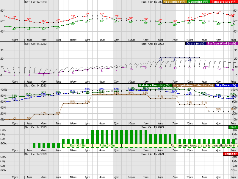
Well, the 18Z, then 0Z models last night did not confirm the potential for a dry game, but still generally show only some light rain through about 1-2 pm (~0.1") and possibly very little before about noon, with most models showing steady rain moving in by 1-2 pm with up to 1/4" through 4-5 pm.
However, the NWS is a bit more aggressive with the rain than the models (and vs. yesterday's forecast at 4 pm, above), showing about 1/4" through 2 pm, with most of that likely coming after about noon and the NWS is showing close to 1" from 2 pm to 8 pm, meaning at least 1/4" is likely from 2-4 pm. Having said that, the NWS-Philly has an uncharacteristically lousy discussion this morning, with very sparse details on Saturday, so I'm not going to include that here - hopefully we'll get a better discussion later today.
So, it's still looking like a mostly dry tailgate (but people should prepare for at least a few showers with up to 0.1" of rain possible, i.e., I'd still recommend a canopy) with steadier rain starting sometime between noon and 1-2 pm, so people should prepare for a wet game with ~1/4" of rain (and maybe up to 1/2") falling during the game. Temps will be in the low 50s for tailgates and the mid/upper 50s for the game, with winds around 7-10 mph (stronger winds with gusts to 25 mph won't hit until Sat night). We can still hope for a completely dry tailgate and a mostly dry game (today's 6Z NAM just came out showing no rain until after 2 pm with <0.1" from 2-5 pm), but that's not the way to bet right now.
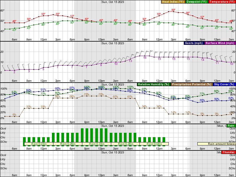
Overall, the NWS is still predicting about 1.5" of rain through about sunrise on Sunday, which should not be enough for flooding in most locations, as rates won't be high enough; most of the models are showing a total of closer to 1" of rain (and Lee Goldberg, last night was calling for only about 1/2-3/4" for our area). And while there might be some lingering light showers through late Sunday morning, much of Sunday looks dry, although cool and windy.
https://forecast.weather.gov/MapClick.php?lon=-74.44946897432685&lat=40.518847127951545
I could be wrong, but it seems like we’ve gotten better news each day with the evening models than we did with the early morning models. So let’s hope for some good news later today!!!
Was thinking the same thing that Sunday is looking worseI could be wrong, but it seems like we’ve gotten better news each day with the evening models than we did with the early morning models. So let’s hope for some good news later today!!!
My weather app for Piscataway shows no rain on Saturday until noon. That would be great for the tailgate. Rain ends around 6 AM Sunday. The rest of Sunday looks dry.
Actually, the models didn't change much at all since yesterday morning, but the NWS forecast became a little rainier, but they have access to far more than models, plus they're professional meteorologists, although they can be wrong, too.I could be wrong, but it seems like we’ve gotten better news each day with the evening models than we did with the early morning models. So let’s hope for some good news later today!!!
Most weather apps typically rely on one primary model and have little human oversight, so their accuracy often suffers compared to the NWS or other media sources which synthesize inputs from numerous models and include a human element in analyzing forecasts. But they have gotten much better over the last 5-10 years.My weather app for Piscataway shows no rain on Saturday until noon. That would be great for the tailgate. Rain ends around 6 AM Sunday. The rest of Sunday looks dry.
However, keep in mind that the NWS doesn't have a profit motive like weather app companies (or local media) do, so they can strictly focus on accuracy, whereas apps have been shown to often over-predict rain (and snow), as people would rather not plan something due to rain than plan it thinking it's going to be dry and be negatively surprised; same thing with underpredicting high temps.
Hoping it is dry through 2pm... will be hard to convince gf to go...
Once there I can say weather was supposed to be good through 5pm and say I am sorry
Tell her "GF's ask what the weather will be. Wives ask how they need to dress."
Or something like that to guilt her into going.
Well….isn’t that the model “changing?” Doesn’t the forecasts change along with the model? Or they just decided to add more rain for the heck of it? Thank you!Actually, the models didn't change much at all since yesterday morning, but the NWS forecast became a little rainier
What I'm saying is that there are far more inputs to any good forecast than these models, including the experience and expertise of the forecasters, who, for example, may decide that one model is more likely to be correct than another for this specific situation (they're not all equal especially with different setups) or they may have noticed that the actual weather conditions changed in a key direction in the 4-6 hours from the time the models initialized (7 pm last night for the 0Z models) to when they put the forecast out (typically 4 am), favoring a particular outcome more. So, the NWS may make minor changes (their changes were fairly minor this morning from yesterday) when the models don't necessarily reflect that. Make sense?Well….isn’t that the model “changing?” Doesn’t the forecasts change along with the model? Or they just decided to add more rain for the heck of it? Thank you!
Yup, thx!What I'm saying is that I typically just discuss the main global models several days out. There are far more inputs to any good forecast than these models, including the experience and expertise of the forecasters, who, for example, may decide that one model is more likely to be correct than another for this specific situation (they're not all equal especially with different setups) or they may have noticed that the actual weather conditions changed in a key direction in the 4-6 hours from the time the models initialized (7 pm last night for the 0Z models) to when they put the forecast out (typically 4 am), favoring a particular outcome more. So, the NWS may make minor changes (their changes were fairly minor this morning from yesterday) when the models don't necessarily reflect that. Make sense?
Good points. It's not science but I have found the weather apps to be pretty good 4-5 days prior. They change a lot leading up to the event but always seem to revert back to the earlier forecast. I say that with years of planning ski trips and making tee times.Most weather apps typically rely on one primary model and have little human oversight, so their accuracy often suffers compared to the NWS or other media sources which synthesize inputs from numerous models and include a human element in analyzing forecasts. But they have gotten much better over the last 5-10 years.
However, keep in mind that the NWS doesn't have a profit motive like weather app companies (or local media) do, so they can strictly focus on accuracy, whereas apps have been shown to often over-predict rain (and snow), as people would rather not plan something due to rain than plan it thinking it's going to be dry and be negatively surprised; same thing with underpredicting high temps.
For Homecoming in a must win game.The get in price on SeatGeek is now $10. Crazy.
SMH
The hourly forecast for Piscataway on weather.com has reached Saturday morning. Their best guess currently is that light showers begin around 9 AM.
Last edited:
The get in price on SeatGeek is now $10. Crazy.
I'm on SH and SG right now. There are MAYBE 50 tickets under $30 available? on SH Maybe 100 or so on Seat Geek under $30? Likely MOST of these tickets are on both sites, as well, so let's not get too crazy here.For Homecoming in a must win game.
SMH
So, the 12Z model suite (initializes with 7 am EST data inputs) is coming out and so far, so good, as the two major regional mesoscale models the NAM and RDPS (American and Canadian models) continue to show zero rain through 2 pm with maybe 0.1" from 2-4 pm. That would be a huge win for us, but let's see what the other models say, as they have mostly shown at least some rain from 11 am to 2 pm (up to 0.1") and then a bit more after that.
Edit: see below - the 12Z GFS is a little wet for the tailgate and game...
Edit: see below - the 12Z GFS is a little wet for the tailgate and game...
Last edited:
Numbers: I hope that is correct!So, the 12Z model suite (initializes with 7 am EST data inputs) is coming out and so far, so good, as the two major regional mesoscale models the NAM and RDPS (American and Canadian models) continue to show zero rain through 2 pm with maybe 0.1" from 2-4 pm. That would be a huge win for us, but let's see what the other models say, as they have mostly shown at least some rain from 11 am to 2 pm (up to 0.1") and then a bit more after that.
I usually don't post partial model suite outcomes, as it can raise false hope - the 12Z GFS just came out and it shows about 0.1" of rain from 8-11 am and another 0.1" from 11 am to 2 pm, as opposed to the 12Z NAM/RDPS, which show no rain before 2 pm and barely any from 2-4 pm. More to come, but unless we see all or maybe all but one model showing no rain through a certain time, I doubt the NWS and other forecasters will change their forecasts much.Numbers: I hope that is correct!
Edit: the 12Z CMC and UK models show no rain through about noon and barely any rain (maybe 0.02") through 2 pm, but then about 0.1-0.2" from 2-4 pm - both are more like the NAM/RGEM. Euro up next.
Edit #2: unfortunately, the Euro is the worst model for us, with about 0.05" of rain through 11 am, then about 0.1" from 11 am to 2 pm and another 0.1" through 4-5 pm - not a deluge, but enough rain to bother most people. Seems to be aligned with the GFS vs. all the other models. So, my guess is not much change in the NWS forecast at 4 pm, but who knows? Still 48+ hours to go (from the 7 am model data inputs this morning)...
Last edited:
And that is what my weather app said 2 days ago...no rain until 3 PM & on. Let's hope that is correct.So, the 12Z model suite (initializes with 7 am EST data inputs) is coming out and so far, so good, as the two major regional mesoscale models the NAM and RDPS (American and Canadian models) continue to show zero rain through 2 pm with maybe 0.1" from 2-4 pm. That would be a huge win for us, but let's see what the other models say, as they have mostly shown at least some rain from 11 am to 2 pm (up to 0.1") and then a bit more after that.
Edit: see below - the 12Z GFS is a little wet for the tailgate and game...
Makes no sense that an app would've shown no rain 48 hours ago, since every global model, 48 hours ago, except the Euro (the NAM/RGEM were not in range yet), was showing 0.1-0.3") before 2 pm. Sounds like a broken clock scenario, lol.And that is what my weather app said 2 days ago...no rain until 3 PM & on. Let's hope that is correct.
I know...weird right? But that is what it said 2 days ago because I was happy no rain during the tailgate and most of the game. I got concerned when all other reports showed rain early on. I can live with no rain until the end. Was just hoping that would be the final forecast.Makes no sense that an app would've shown no rain 48 hours ago, since every global model, 48 hours ago, except the Euro (the NAM/RGEM were not in range yet), was showing 0.1-0.3") before 2 pm. Sounds like a broken clock scenario, lol.
COM'ON BABY!!!! I CAN ONLY "DANCE" FOR A LITTLE WHILE LONGER (softball playoffs continue this evening...)!!!I usually don't post partial model suite outcomes, as it can raise false hope - the 12Z GFS just came out and it shows about 0.1" of rain from 8-11 am and another 0.1" from 11 am to 2 pm. More to come, but unless we see all or maybe all but one model showing no rain through a certain time, I doubt the NWS and other forecasters will change their forecasts much.
Edit: the 12Z CMC and UK models show no rain through about noon and barely any rain (maybe 0.02") through 2 pm, but then about 0.1-0.2" from 2-4 pm - both are more like the NAM/RGEM. Euro up next.
Can we safely say that if it does rain (either during tailgate or game), that it will be a lighter rain shower rather than a soaking downpour?
COM'ON BABY!!!! I CAN ONLY "DANCE" FOR A LITTLE WHILE LONGER (softball playoffs continue this evening...)!!!
You need to SHUT UP and KEEP DANCING.
Bad cards - probably should've lost more really.
Then you should consider that a win.
Variance. You'll have your day in the sun, and it will be glorious.
I play Parx a fair amount during the day, or at least I used to. Good chance I'll be at 1/3 tomorrow.
Every now and then you're funny 65!Don’t forget, systems can be stubborn, not able adjust in real time and often highly flawed.
Wait, what are we discussing here ?
Oh, I know. Been playing poker occasionally (once a month or so) in the casinos (used to play at the Taj in AC before Parx opened up their poker room) since they opened in the early 90s for poker in AC, plus we have our regular poker games (been doing that monthly since the late 80s) and I used to play a lot on line in the 2000s, before they were outlawed in the US (the new NJ sites aren't nearly as good). And I know I want people calling off multiple bets with a low probability of winning, but it doesn't help when they win those more than probability says they should.Then you should consider that a win.
Variance. You'll have your day in the sun, and it will be glorious.
I play Parx a fair amount during the day, or at least I used to. Good chance I'll be at 1/3 tomorrow.
I'll play no limit hold-em occasionally, i.e., when I have to, lol, but maybe having played mostly limit games most of my life, until hold em became the big game in the 2000s, I still prefer limit games in the 5/10 to 10/20 range.
Not sure if you mean during tailgates or the game, so I'll address both. First, though, I didn't think the rain (<0.1") during the spring game was an issue, but I'm pretty insensitive to rain, especially if it's not a cold rain (like colder than 45F out with some wind and it won't be on Saturday). Very likely that the total rainfall prior to noon will be <0.1", which isn't a big deal, especially if one has a canopy.If it does rain, will it be worse than the spring game? @RU848789
Now, if you're asking about the game, the rainfall is a tougher question, plus most don't have shelter: could easily be 0.1-0.2" (or even up to 0.3") and I would call that worse than the spring game, but we also might get only 0.1" during the game, which is pretty similar to what we had in the spring game over a shorter, 2 hour period.
So, the NWS-Philly discussion sounds a bit less wet than this morning's discussion, but the NWS hasn't updated their hourly weather grids yet, so we don't have updated rainfall forecasts - although they were predicting close to 2" of rain overall for all of CNJ this morning and the text below says 1-1.5" amounts for CNJ, so I'm hopeful the rainfall forecast is going to decrease (it did for adjacent Union County and Staten Island, which are overseen by the NWS-NYC). I'm especially hoping they decrease the rainfall for 8 am to 2 pm in P'way from 0.27" this morning to about 0.1", which is what the NWS-NYC is showing for Union/SI (but I still think they'll show up to 1/4" of rain for the game). That would likely mean little to no rain before noon for tailgates. Will update this post when the hourly grids get updated.I usually don't post partial model suite outcomes, as it can raise false hope - the 12Z GFS just came out and it shows about 0.1" of rain from 8-11 am and another 0.1" from 11 am to 2 pm, as opposed to the 12Z NAM/RDPS, which show no rain before 2 pm and barely any from 2-4 pm. More to come, but unless we see all or maybe all but one model showing no rain through a certain time, I doubt the NWS and other forecasters will change their forecasts much.
Edit: the 12Z CMC and UK models show no rain through about noon and barely any rain (maybe 0.02") through 2 pm, but then about 0.1-0.2" from 2-4 pm - both are more like the NAM/RGEM. Euro up next.
Edit #2: unfortunately, the Euro is the worst model for us, with about 0.05" of rain through 11 am, then about 0.1" from 11 am to 2 pm and another 0.1" through 4-5 pm - not a deluge, but enough rain to bother most people. Seems to be aligned with the GFS vs. all the other models. So, my guess is not much change in the NWS forecast at 4 pm, but who knows? Still 48+ hours to go (from the 7 am model data inputs this morning)...
Edit: good news from the NWS, as they significantly lowered their P'way rainfall forecast from 8 am to 2 pm from 0.27" of rain to 0.03" of rain. And they decreased from about 1" from 2 pm to 8 pm to ~0.3" which likely means just light rain for the game. Can't lock that in yet, but a nice move.
National Weather Service Mount Holly NJ
334 PM EDT Thu Oct 12 2023
An eastward moving surface low in Ohio on Saturday is expected
to transfer its energy on Saturday night to another low moving
up the Southeast and Middle Atlantic Coasts. The combined system
will likely move out to sea quickly on Sunday.
Moisture from the west and south is forecast to overcome the
dry air in our region on Saturday morning. As a result, cloud
bases should lower and rain will likely begin to overspread our
area. The rain is expected to become moderate to heavy at times
from Saturday afternoon into Saturday night as the lift and
energy from the low approaching from the west passes over and
through our region, producing a good amount of lift. The mid
level trough should then bring an end to the steady rain on
Sunday morning as it passes overhead. Showers are forecast to
linger into Sunday morning, with some dry air arriving from the
north in the afternoon.
The axis of the heaviest rain in our region continues to shift
a bit with each set of model runs. Presently, it seems to be
focused on southeastern Pennsylvania, central and southern New
Jersey, Delaware and eastern Maryland. Widespread 1.0 to 1.5
inch totals are expected with locally higher amounts possible.
The steady rain should fall over a 12 to 18-hour period, so
there may be no more than some spotty flooding in areas of poor
drainage.
The rain and cloud cover will likely keep temperatures cool.
Afternoon readings should favor the 50s and lower 60s on
Saturday and Sunday. An easterly wind 5 to 10 MPH on Saturday is
expected to become northerly 10 to 15 MPH on Sunday.
Last edited:
Similar threads
- Replies
- 5
- Views
- 509
- Replies
- 41
- Views
- 2K
- Replies
- 5
- Views
- 379
- Replies
- 74
- Views
- 2K
ADVERTISEMENT
ADVERTISEMENT