Good idea, should be merged. 👍Should be merged with the first one.

ADVERTISEMENT
You are using an out of date browser. It may not display this or other websites correctly.
You should upgrade or use an alternative browser.
You should upgrade or use an alternative browser.
OT: 12/16/20 Snowstorm Thread: First Significant Winter Storm of the Season - Major Snow/Sleet/Rain
- Thread starter RU848789
- Start date

Numbers saying he hasn't seen this level of model consensus 4-5 days out...if i had a dollar
Show your work. This level of model consensus 4-5 days out is highly unusual. Just ask any of the mets who post here occasionally or anyone on the weather boards.
Never saw any other thread (still haven't) and I don't start winter storm threads before 5 days out as a rule (this was 5+, right on the edge), but someone could start a thread every week 10 days out on a potential snowstorm at least once a week, as we see that in the long range models all the time - of course they'd be wrong most of the time. This one won't be wrong - we're going to get a winter storm - just don't know all the details yet. I was the first person who mentioned this in Tango's snow showers thread Wednesday night though.Duplicate thread #s. Someone called this on Tuesday
Good point and agree - updated thread title to include the mention of the Monday potential; this morning's GFS and NAM both showing a 2-4/3-5" type event - but not quite in the same locations.I think Mondays event should be worried about first. I have seen these type event sneak up on people in December where colder air persists
A possible major snowstorm amid a pandemic, numbers you must be in your glory
Never saw any other thread (still haven't) and I don't start winter storm threads before 5 days out as a rule (this was 5+, right on the edge), but someone could start a thread every week 10 days out on a potential snowstorm at least once a week, as we see that in the long range models all the time - of course they'd be wrong most of the time. This one won't be wrong - we're going to get a winter storm - just don't know all the details yet. I was the first person who mentioned this in Tango's snow showers thread Wednesday night though.
OT: Snow showers late Wednesday morning and afternoon
Nope. Although I did fiddle around with the snowblower so maybe that’s why it’s passing us? Lol Well, f'd that one up with the KR jinx. Light snow over here in Wall. Salted the entire yard to prevent any accumulation. [roll]
 rutgers.forums.rivals.com
The no snow this past winter should have been a precursor of bad things to come. I somewhat remember the “ olden days “, when granny and pappy would say to the kids, we need the first frost or snows to kill the weeds and germs. I guess that’s the problem.😷they only take credit for the ones they get right, its amazing how quickly the huge busts are forgotten. There have been several in the past few years, was their one last year? I forget
Show your work. This level of model consensus 4-5 days out is highly unusual. Just ask any of the mets who post here occasionally or anyone on the weather boards.
dude I have read your threads for years, I can find you say something similar last year
Show your work. This level of model consensus 4-5 days out is highly unusual. Just ask any of the mets who post here occasionally or anyone on the weather boards.
do you want me to put that thread or put a link here....Feb 7, 2019...turns out that storm was a big bust for most of the area more sleet than anything
In an unusual occurrence, we actually have at least temporary near consensus on a storm 5 days out. I'm guessing that's just a very unlikely coincidence and we'll see more divergence later. Anyway, every global model is now showing a weaker initial low, cutting towards the eastern Great Lakes and most show a weak secondary low forming near the coast.
This means less precip, but also less warm air intrusion, meaning more snow than rain, but not a huge wintry event (but potentially significant; some sleet/freezing rain are possible also) - more in the range of a 2-4/4-8" kind of event, with a ceiling of 10" and a floor of 1-2". This is looking like a Tuesday morning (starting around rush hour) through early Weds am (wee hours) storm, right now.
OT: Winter storm for 2/12 - Big Mess of Snow/Sleet/Rain (after minor snowfall on 2/11)
After a very cold, but not-so-snowy 2nd half of January (for the Philly-NYC area; tons of snow everywhere else in the eastern 1/3 of the USA) and the big warm-up this week, it definitely looks like we're entering a fairly stormy pattern (but fairly normal in temps) starting early next week...
rutgers.forums.rivals.com
the high level of model consensus virtually guarantees its going to change 10x between now and Wednesday as virtually every storm does, if the same exact models hold all the way through 6 days out of model runs then you can declare victory on that one
YOU maybe good. But we got snow last week, while you got none.Already taken care of... 😎
We're good, boys. We're good.
OT: Cold/Snowy Pattern Continues for Early April: a few inches on 4/3? More next weekend?
As I've been discussing for a few days on the 3/21 snowstorm thread, the cold and potentially snowy pattern we had through March looks to continue for at least the first 10 days of April. After a brief, modest warm-up through this weekend, an anomalously cold pattern reloads through at least...
rutgers.forums.rivals.com
this one about model agreement 8-9 days out in freaking April
Beyond that both the GFS and CMC show a more substantial storm hitting our area on 4/7 or 4/8, with several to many inches possible. The Euro was showing the same thing for the past couple of runs, but the 12Z run went south of Baltimore with the snow, but that's not unusual this far out. The point is that all three major long range global models are showing a significant snowstorm in the NE US on freakin' April 7th/8th, which is almost unheard of model agreement for snow this time of the year. There could be other threats, as it’s difficult to predict wave spacing/timing this far out.
The euro continues to show a quick hit of snow on Monday with light accumulation, especially away from the coast.
Prior to Wednesday's storm, there will be a first system that affects the region Monday. This looks to be mainly rain near the coast with rain possibly mixed with snow at times near the I-95 corridor. There could be some accumulating snow north of the urban corridor but the amounts should be 1-2 inches or less and be mainly confined to our northern zones from the Lehigh Valley into the southern Poconos and NW New New Jersey.

Prior to Wednesday's storm, there will be a first system that affects the region Monday. This looks to be mainly rain near the coast with rain possibly mixed with snow at times near the I-95 corridor. There could be some accumulating snow north of the urban corridor but the amounts should be 1-2 inches or less and be mainly confined to our northern zones from the Lehigh Valley into the southern Poconos and NW New New Jersey.
There is increasing confidence a coastal storm will impact the region Wednesday with strong winds and heavy precipitation likely. What remains uncertain is the specific details such as where the rain/snow line sets up and the heaviest snow amounts fall. This is because temperatures are likely to be near freezing so just a degree or two either way will make a big difference!
Our forecast models continue to vary in the exact forecast details of the storm and this will likely continue to be the case over the weekend as the upper level energy that will eventually help fuel this storm is still over the relatively data void Pacific Ocean as of Saturday morning.


Our forecast models continue to vary in the exact forecast details of the storm and this will likely continue to be the case over the weekend as the upper level energy that will eventually help fuel this storm is still over the relatively data void Pacific Ocean as of Saturday morning.
That's the key right there.To be honest i haven't looked at one model yet or read the weenie board. When we get into the 72 hour window i will start looking
You realize that thread was on this week's "storm" don't you?OT: Snow showers late Wednesday morning and afternoon
Nope. Although I did fiddle around with the snowblower so maybe that’s why it’s passing us? Lol Well, f'd that one up with the KR jinx. Light snow over here in Wall. Salted the entire yard to prevent any accumulation. [roll]
Three of four of the major 12Z global models this afternoon showed a major snowstorm (8" or more) for most of the Philly-NJ-NYC region and all four of tonight's 12Z models show a major *8" or more) to historic (historic is 12-18" to me - we don't get too many of those) snowstorm on Wednesday afternoon through Thursday morning. I don't think I've ever seen this level of near model consensus 4.5 days out.
WxRisk/DT could end up being right on this one, as he's been honking on it for a few days given the great pattern, i.e., we have a -NAO (North Atlantic Oscillation Index) and a 50N/50W low to hold the cold air in place, plus what looks to be the right jet stream/trough approaching and eventual storm cyclgenesis and track along the coast; it's the last few items that have to mesh perfectly to get us major snowfall, which is why major snowfalls are fairly rare around here.
Doesn't guarantee it's going to happen, but it's starting to look like we're in for at least a moderate to significant snowfall, with the potential for much more. Of course, being this far out, numerous things can still happen to derail this, such as a further inland/warmer/wetter track or a further offshore/less precip track, but if we see anything like the track being advertised, with the cold air expected to be in place, this could be a pretty big snowstorm, even for the 95 corridor and maybe the coast (always at most risk for rain with the ocean being fairly warm this time of year). There could also be significant winds (blizzard conditions are in play) and some tidal flooding. Since this is so unusual, below are the snowfall maps for the storm.
One more point: the Euro is also showing 1-2" of snow on Monday along and just NE of 95 and 2-5" NW of 95 and especially N of 78 and the GFS is showing 1-3" or so SE of 95 and towards the coast with <1" NW of 95, while the NAM is showing a general 2-4" of snow for almost everyone (these have to be subtracted from the map below for the Weds event) and the UK/CMC are showing almost all rain and only near the coast, so oddly, much less consensus on an earlier event (but which is much more borderline with regard to having enough cold air).
https://www.weather.gov/phi/
https://www.americanwx.com/bb/topic...-17-2020/page/5/?tab=comments#comment-5725302
https://www.facebook.com/WxRisk
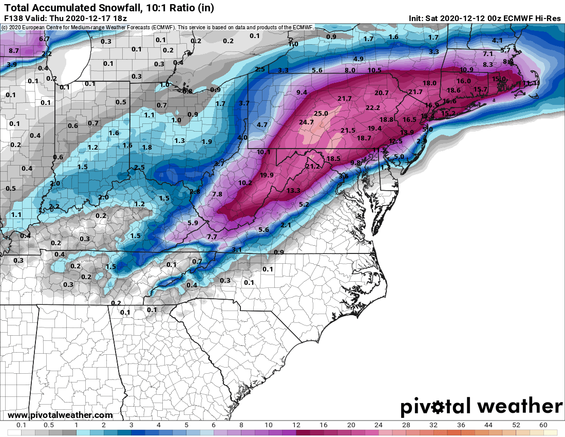
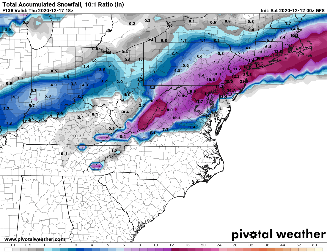
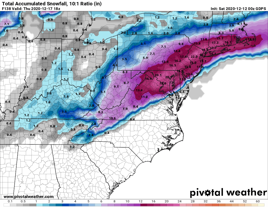
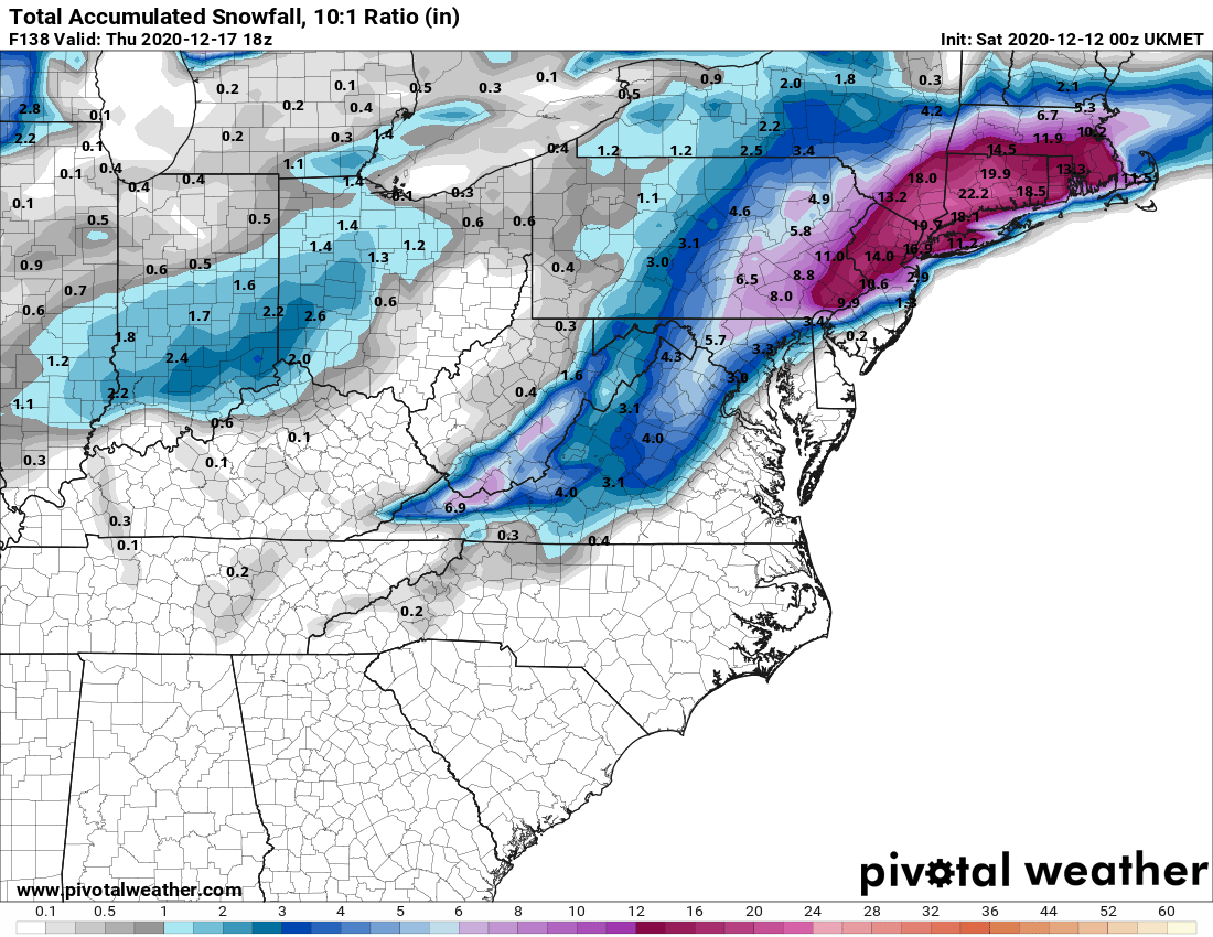
Still have model consensus on a major snowstorm on Weds/Thurs with every major model showing a foot or more of snow for most of the area from Philly to NYC and beyond, except at the coast in 2 of the models (with snow to rain). Very unusual for all of the models to be showing this big of a snowstorm this far out, as I said before. Far from a lock 4 days out, but this is the best threat for a major snowstorm since Jan-2016, IMO.
The Monday threat is still iffy with a couple of models showing a few inches (with the GFS showing several inches) and a couple showing mostly rain. That one will likely be a borderline event right up to the event, with high bust potential either way.
do you want me to put that thread or put a link here....Feb 7, 2019...turns out that storm was a big bust for most of the area more sleet than anything
In an unusual occurrence, we actually have at least temporary near consensus on a storm 5 days out. I'm guessing that's just a very unlikely coincidence and we'll see more divergence later. Anyway, every global model is now showing a weaker initial low, cutting towards the eastern Great Lakes and most show a weak secondary low forming near the coast.
This means less precip, but also less warm air intrusion, meaning more snow than rain, but not a huge wintry event (but potentially significant; some sleet/freezing rain are possible also) - more in the range of a 2-4/4-8" kind of event, with a ceiling of 10" and a floor of 1-2". This is looking like a Tuesday morning (starting around rush hour) through early Weds am (wee hours) storm, right now.
OT: Winter storm for 2/12 - Big Mess of Snow/Sleet/Rain (after minor snowfall on 2/11)
After a very cold, but not-so-snowy 2nd half of January (for the Philly-NYC area; tons of snow everywhere else in the eastern 1/3 of the USA) and the big warm-up this week, it definitely looks like we're entering a fairly stormy pattern (but fairly normal in temps) starting early next week...
OT: Cold/Snowy Pattern Continues for Early April: a few inches on 4/3? More next weekend?
As I've been discussing for a few days on the 3/21 snowstorm thread, the cold and potentially snowy pattern we had through March looks to continue for at least the first 10 days of April. After a brief, modest warm-up through this weekend, an anomalously cold pattern reloads through at least...
this one about model agreement 8-9 days out in freaking April
Beyond that both the GFS and CMC show a more substantial storm hitting our area on 4/7 or 4/8, with several to many inches possible. The Euro was showing the same thing for the past couple of runs, but the 12Z run went south of Baltimore with the snow, but that's not unusual this far out. The point is that all three major long range global models are showing a significant snowstorm in the NE US on freakin' April 7th/8th, which is almost unheard of model agreement for snow this time of the year. There could be other threats, as it’s difficult to predict wave spacing/timing this far out.
Close, but not exactly, IMO. The first one I was clear saying it was "temporary" consensus, since there wasn't consensus before and I expected things to change and they did. Storm busted for some (more sleet than snow, but still frozen). 2nd one on an April snow potential is a mix in that it was unusual to have close to model consensus in April, but neither example was model consensus on a major to historic snowstorm, which is what we saw last night, as per my post.
And that continues today. Again, this all might not happen, as we've seen major busts the day of a storm (Jan-15 and March 2001 come to mind), even, but every major to historic storm we've had was generally well forecast by 2-3 days out and I feel pretty confident that if we see this kind of model consensus continue tomorrow, when the energy for the eventual storm comes ashore in the Pac NW and the system is sampled much better (meaning better model input data), then I'll be all-in for at least a major snowstorm (almost there now).
Every year, its the same nonsense. Who cares. Why is there this need to fact check #'s posting history? I just dont get it... unless you two are bff offline and just enjoy the banter. Either way, I appreciate the weather info from #'s, and see value in it. So thank you.
A lot of SCIENCE there.A possible major snowstorm amid a pandemic, numbers you must be in your glory
Close, but not exactly, IMO. The first one I was clear saying it was "temporary" consensus, since there wasn't consensus before and I expected things to change and they did. Storm busted for some (more sleet than snow, but still frozen). 2nd one on an April snow potential is a mix in that it was unusual to have close to model consensus in April, but neither example was model consensus on a major to historic snowstorm, which is what we saw last night, as per my post.
And that continues today. Again, this all might not happen, as we've seen major busts the day of a storm (Jan-15 and March 2001 come to mind), even, but every major to historic storm we've had was generally well forecast by 2-3 days out and I feel pretty confident that if we see this kind of model consensus continue tomorrow, when the energy for the eventual storm comes ashore in the Pac NW and the system is sampled much better (meaning better model input data), then I'll be all-in for at least a major snowstorm (almost there now).
Lmfao..insufferable..just admit you said it before and move on
Oh i also think there have been big storms that didn't pan out in last 4 years
And we arent 2-3 days out either
Still have model consensus on a major snowstorm on Weds/Thurs with every major model showing a foot or more of snow for most of the area from Philly to NYC and beyond, except at the coast in 2 of the models (with snow to rain). Very unusual for all of the models to be showing this big of a snowstorm this far out, as I said before. Far from a lock 4 days out, but this is the best threat for a major snowstorm since Jan-2016, IMO.
The Monday threat is still iffy with a couple of models showing a few inches (with the GFS showing several inches) and a couple showing mostly rain. That one will likely be a borderline event right up to the event, with high bust potential either way.
NWS Mt. Holly is pretty bullish on the snow...
LONG TERM /TUESDAY NIGHT THROUGH FRIDAY/...
Confidence is building in regards to the mid week coastal storm and
its potential impacts. There remain some slight differences between
the models, such as timing and placement of the low, which could
impact the final track and specifics with the forecast such as snow
amounts and the location of the rain/snow mixing line. But it`s
becoming even more likely that a significant snowfall event will
occur for portions of our forecast area Wednesday into Wednesday
night.
The latest guidance has trended a little slower with the low, which
could potentially lead to more snow as more precipitation could fall
coincidentally with the cold air. The models are in good
agreement with the location of the high moving across southeast
Canada Tuesday night into Wednesday, which will set up the cold
air across the region. By Tuesday night and Wednesday, an area
of low pressure is forecast to move up the southeast coast into
the Mid Atlantic region, then continue to our east and out to
sea Wednesday night into Thursday. The current track from the
model guidance keeps the low near the coast as it passes by.
This will bring precipitation to the entire forecast area,
possibly starting as early as Wednesday morning, and continuing
through the day into Wednesday night. With the current track,
the forecast is for snow to start virtually everywhere Wednesday
morning, before a mix and/or change to rain begins to lift
northward into portions of southern/central Delaware and
Maryland, as well as southern/eastern New Jersey; just south and
east of the I-95 corridor. Along and north of the I-95
corridor, the forecast is for snow during the duration of the
event. Eventually by Wednesday evening and overnight, cold air
will move back in for all places, and everyone could change back
over to snow where it changed to a mix or rain during the day.
The precipitation types will be dependent on the track of the
low and thermal profiles, so this could all change in the coming
days. Although we do not have specific snowfall amounts
forecast yet, all guidance is pointing to a significant snowfall
accumulation for eastern Pennsylvania, much of New Jersey,
northern Delaware and northern Maryland.
Another concern becoming more likely with the storm will be strong,
gusty winds, with wind gusts of at least 25-35 mph possible,
especially near the coast where even higher gusts could occur.
Speaking of the coast, with strong, steady northeast flow, and
being only two days removed from the new moon, there will also
be a chance for coastal flooding.
https://forecast.weather.gov/produc...&format=CI&version=1&glossary=1&highlight=off
Don't enjoy bickering at all, but will always defend myself, especially from unprovoked attacks.Every year, its the same nonsense. Who cares. Why is there this need to fact check #'s posting history? I just dont get it... unless you two are bff offline and just enjoy the banter. Either way, I appreciate the weather info from #'s, and see value in it. So thank you.
there was no attack. all I said was that I have heard it before about you saying models are in agreement 5-7 days out, which really means nothing since they are likely to change before the storm gets here
Say we get 14" of snow through Wed night and an extra 1" from Thurs morning showers what do you think the roads will be like Thurs afternoon?
When I answered his question, I was referring to you calling me insufferable for merely defending my position - that's an attack. Your posts before that were not attacks, but they were bickering, as were the posts about who started the thread, which were just stupid. The point remains that this was highly unusual model consensus for a major to historic snowstorm almost 5 days out - we have model consensus all the time 5 days out for easy forecasts like most of the games this season - and the two examples you cited weren't for major to historic snowstorms. Can we get back to talking about this storm? And Monday's which is all over the map?there was no attack. all I said was that I have heard it before about you saying models are in agreement 5-7 days out, which really means nothing since they are likely to change before the storm gets here
A
anon_ivydyf0amkzay
Guest
Storm will most likely continue to move N & W and from N Brunswick south will be a mix of about 2” and rain as always. I want Snow in Hamilton

So much for model consensus..and so it begins
Man I have like a dozen brand new snow shovels, a couple new electric snow shovels and some sleds to sell. Time to make haste and take advantage of panic buyers. And clear out the garage !
Shop Rite gonna be packed tomorrow. To hell with social distancing. I want my friggin eggs and milk,
No matter where you go the next two weeks the stores will be loaded... Went past Target in Menlo Park... packed to the brim.... guess people don’t give a shat ....Hey Murphy .... here’s where your spread is coming from....Shop Rite gonna be packed tomorrow. To hell with social distancing. I want my friggin eggs and milk,
What does the loblaw in your user name mean?Every year, its the same nonsense. Who cares. Why is there this need to fact check #'s posting history? I just dont get it... unless you two are bff offline and just enjoy the banter. Either way, I appreciate the weather info from #'s, and see value in it. So thank you.
Don't forget your Lo-Bro!Shop Rite gonna be packed tomorrow. To hell with social distancing. I want my friggin eggs and milk,
No more Hillsborough Deli updates?Shop Rite gonna be packed tomorrow. To hell with social distancing. I want my friggin eggs and milk,
Similar threads
- Replies
- 62
- Views
- 3K
- Replies
- 608
- Views
- 18K
- Replies
- 771
- Views
- 20K
ADVERTISEMENT
ADVERTISEMENT