I'll plug in my snowblower too just in case. . . .I brought my flags in last night.
We had some pretty strong gusts.
Hope @knightfan7 does OK.
I'll plug in my snowblower too just in case. . . .I brought my flags in last night.
We had some pretty strong gusts.
(3) This morning on 18th Avenue by the Wall High School Athletic Complex.Noticed JCPL trucks (1) in an age restricted community; (2) on a wildlife management area paved road, both parked and sitting looking at their computers in their trucks. Wondering if they are deployed ahead of the storms. This was in Brick and Wall this afternoon.
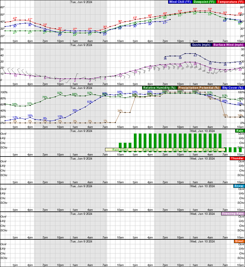
Looking at the projected winds for Allenwood, NJ (Wall/Herbertville), and dont see anything too concerning?(3) This morning on 18th Avenue by the Wall High School Athletic Complex.
Same thing.
The gust numbers are a little concerning considering the length of time.Looking at the projected winds for Allenwood, NJ (Wall/Herbertville), and dont see anything too concerning?
That may pump up run #'s in the 52nd!The gust numbers are a little concerning considering the length of time.
Those are serious gusts. If they verify, with fully saturated (and beyond) soils, we're going to see a fair number of trees come down. Nearly 3" of rain won't help either.Looking at the projected winds for Allenwood, NJ (Wall/Herbertville), and dont see anything too concerning?
Attendance will likely suffer at the bball game tomorrow night
You still don’t think they’ll postpone the game as the Raritan is expected to flood and it is fairly near the Rutgers campus and majority of the fanbase will be coming that way and could be at risk?Definitely
So it's going be windy and its going to rain a lot.Mt Holly disco
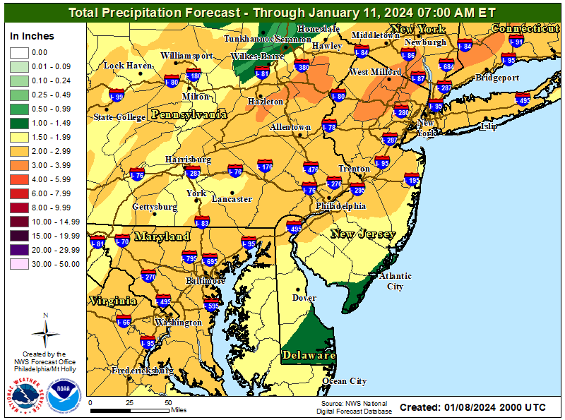
A strong upper-level trough will lift across the eastern U.S.
Tuesday into Wednesday, and it will drive a powerful surface
low up the Ohio Valley and across the eastern to central Great
Lakes. This will place our region on the warmer side and
therefore mostly rain is expected. There is however a short
window of opportunity that it starts as some snow or a mix
mainly north and west of I-95 (perhaps some light accumulations
across parts of the northwestern zones), however with robust
warm air advection any of this will quickly change to rain. The
rain will become heavy at times especially late Tuesday
afternoon and Tuesday night before tapering off to some showers
Wednesday morning. A southeasterly 925 mb jet on the order of
50-75 knots later Tuesday and Tuesday night will advect in ample
moisture off the Atlantic. In addition, this flow veers to
southwesterly at 500 mb and increases to 80-110 knots. The
guidance shows an extensive plume of high precipitable water
(1.0-1.5 inches) for this time of year connected all the way
into the western Caribbean. This amount of moisture along with
strong forcing for ascent will bring widespread rain (2-3 inches
likely, with 4 inches possible) across the entire region with
the heaviest occurring Tuesday night. A period of enhanced
rainfall rates combined with already saturated ground, which
will be even more swollen given snow melt across the northern
areas, will significantly increase the flooding risk. Due to the
combination of all of these factors, a Flood Watch has been
issued for Tuesday afternoon through Wednesday evening.
The upper-level trough or closed low may take on a negative
tilt Tuesday night, and this may inject some elevated
instability especially closer to frontal passage and therefore a
few rumbles of thunder could be possible. The thunder potential
remains low confidence, but something to watch especially given
the intense wind field not all that far above the surface ahead
of the cold front.
The extremely strong low-level jet combined with a tightening
surface pressure gradient will lead to strong winds particularly
Tuesday night into early Wednesday. However, strong low-level
warm air advection and deep moist profiles may prevent at least
some of the strongest winds from mixing down to the surface.
Inland, the strongest sustained winds Tuesday night are
forecast to be 25 to 35 mph with gusts generally around 40 to
50 mph. Along the immediate coast, an area of stronger winds is
likely due to the decreased friction over the open waters with
the southeasterly low-level winds. At the immediate coast,
sustained winds are forecast to be 35 to 45 mph with gusts up to
60 mph possible. With the potential for the strongest gusts to
be damaging, a High Wind Watch has been issued for the coastal
strips of New Jersey and Delaware.
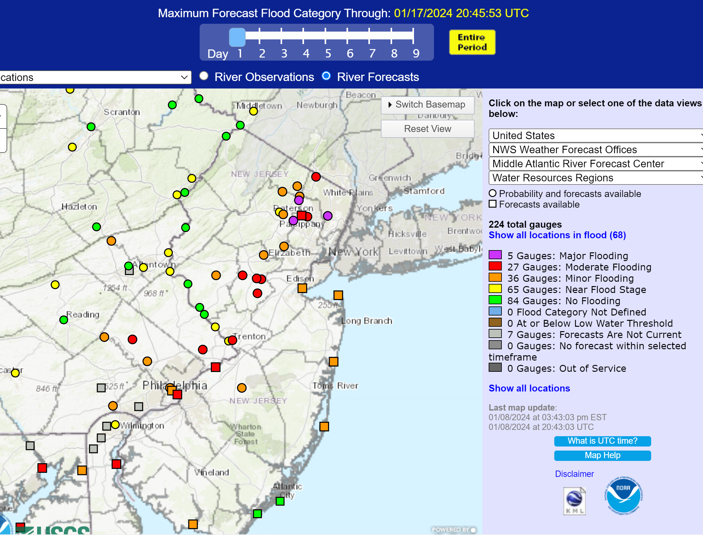
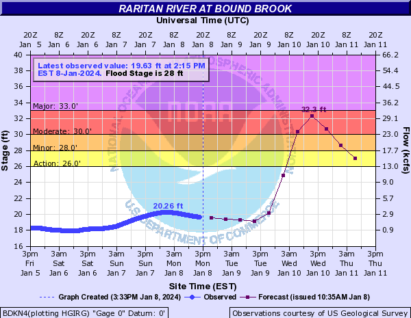
There is no threat of flooding that much. People cross over the Rt 18 Bridge as Landing Lane Bridge is already closed. There are no dangerous low roads by the RAC and there are plenty alternatives to those that usually drive River Road. The bigger threat is a power outage because of the high winds.You still don’t think they’ll postpone the game as the Raritan is expected to flood and it is fairly near the Rutgers campus and majority of the fanbase will be coming that way and could be at risk?
GotchaThere is no threat of flooding that much. People cross over the Rt 18 Bridge as Landing Lane Bridge is already closed. There are no dangerous low roads by the RAC and there are plenty alternatives to those that usually drive River Road. The bigger threat is a power outage because of the high winds
The more severe flooding will be overnight and into the morning, but there may be some impact during/after the game. Enough to keep people away, imo... I'm on the fence about going, myself, as I have to travel about 45 min through areas prone to flooding.You still don’t think they’ll postpone the game as the Raritan is expected to flood and it is fairly near the Rutgers campus and majority of the fanbase will be coming that way and could be at risk?
I get to the game by taking Amwell from Hillsborough into Somerset...but crossing the Millstone might be an issue even though its more likely it will be overnight into Wednesday that it likely rises...another option is Weston Canal to 287 but again that could be an issue on the way home. Raritan flooded down 206 last month although it took sometime. Peeps might not want to take the risk of what happens AFTER the game.The more severe flooding will be overnight and into the morning, but there may be some impact during/after the game. Enough to keep people away, imo... I'm on the fence about going, myself, as I have to travel about 45 min through areas prone to flooding.
Close to a zero chance of the RAC being impacted and if there is going to be river flooding from the Raritan (like the flooding that postponed the RU football game after Ida), that won't happen until well after the rain is over, which would be Wednesday at the earliest. Heavy rain and gusty winds are not reasons to cancel the game. The biggest risk to attendance at the game is the shitty way the team has been playing.You still don’t think they’ll postpone the game as the Raritan is expected to flood and it is fairly near the Rutgers campus and majority of the fanbase will be coming that way and could be at risk?
not true....biggest impact of storm intensity at exactly when people are travelling to and leaving the game....5-11 time period with the heaviest rains is plenty to scare people away. Stop being so selfish, its not about you, its about what others want to riskClose to a zero chance of the RAC being impacted and if there is going to be river flooding from the Raritan (like the flooding that postponed the RU football game after Ida), that won't happen until well after the rain is over, which would be Wednesday at the earliest. Heavy rain and gusty winds are not reasons to cancel the game. The biggest risk to attendance at the game is the shitty way the team has been playing.
Rain wishcasting.not true....biggest impact of storm intensity at exactly when people are travelling to and leaving the game....5-11 time period with the heaviest rains is plenty to scare people away. Stop being so selfish, its not about you, its about what others want to risk
I get to the game by taking Amwell from Hillsborough into Somerset...but crossing the Millstone might be an issue even though its more likely it will be overnight into Wednesday that it likely rises...another option is Weston Canal to 287 but again that could be an issue on the way home. Raritan flooded down 206 last month although it took sometime. Peeps might not want to take the risk of what happens AFTER the game.
Is this a serious post? I never said anything about there being no impacts all over the place due to urban flooding and eventual stream flooding - have you even read my posts? I've been warning people about this storm and the potential flooding impacts for a week now.not true....biggest impact of storm intensity at exactly when people are travelling to and leaving the game....5-11 time period with the heaviest rains is plenty to scare people away. Stop being so selfish, its not about you, its about what others want to risk
Agreed, the threat to the game is very low, but there are travel risks anytime there is heavy rain, especially if there is heavy rainfall rate over one area for awhile, which could lead to urban/flash flooding, which is why people need to check NWS sources before driving in such conditions.The RAC won't be directly affected unless the roof leaks. But getting there from certain areas could be problematic (or more likely, getting back home) as low lying areas along your route flood get closed off. Little culverts end up getting inundated, and then you have to figure out how to get around the closure.
Here ya go:
Free Accurate Forecast for NB
Complete, updated, free and accurate. With Zero BS. Enjoy!
All Locations Available!
From probably the most predatory, slimy source out there, lol. They're well known for trying to generate clicks, especially as they're the ones who started putting out 45 and then even 90 day forecasts, which are 100% useless. They also wanted to privatize the NWS and have private companies charging for weather data and forecasts. I'm sure their short-term forecasts are fine, but why give clicks to a company like that?Here ya go:
Free Accurate Forecast for NB
Complete, updated, free and accurate. With Zero BS. Enjoy!
All Locations Available!
From probably the most predatory, slimy source out there, lol. They're well known for trying to generate clicks, especially as they're the ones who started putting out 45 and then even 90 day forecasts, which are 100% useless. They also wanted to privatize the NWS and have private companies charging for weather data and forecasts. I'm sure their short-term forecasts are fine, but why give clicks to a company like that?
https://www.sciencealert.com/how-many-days-can-you-trust-the-weather-forecast-for