Thought that Hungarian Nut rolls was a category of videos that are only watched in private browsing mode. 😀
No, it something my Hungarian wife and I practice


Follow along with the video below to see how to install our site as a web app on your home screen.
Note: This feature may not be available in some browsers.
Thought that Hungarian Nut rolls was a category of videos that are only watched in private browsing mode. 😀
Is that like the alligator roll that Maryland player did on Vedral, but on the nuts? Does it hurt?No, it something my Hungarian wife and I practice
I agree . It’s a good premium site level information provided here .Thanks Numbers, really appreciate these threads. I am a snow weenie so a nice snowfall would be fun since I'm working from home and my 2 yr old daughter would love it I think. When are the next model runs?
bac posting some wishcasting!this is a good first call for now and can be adjusted as the mesoscale models come into range


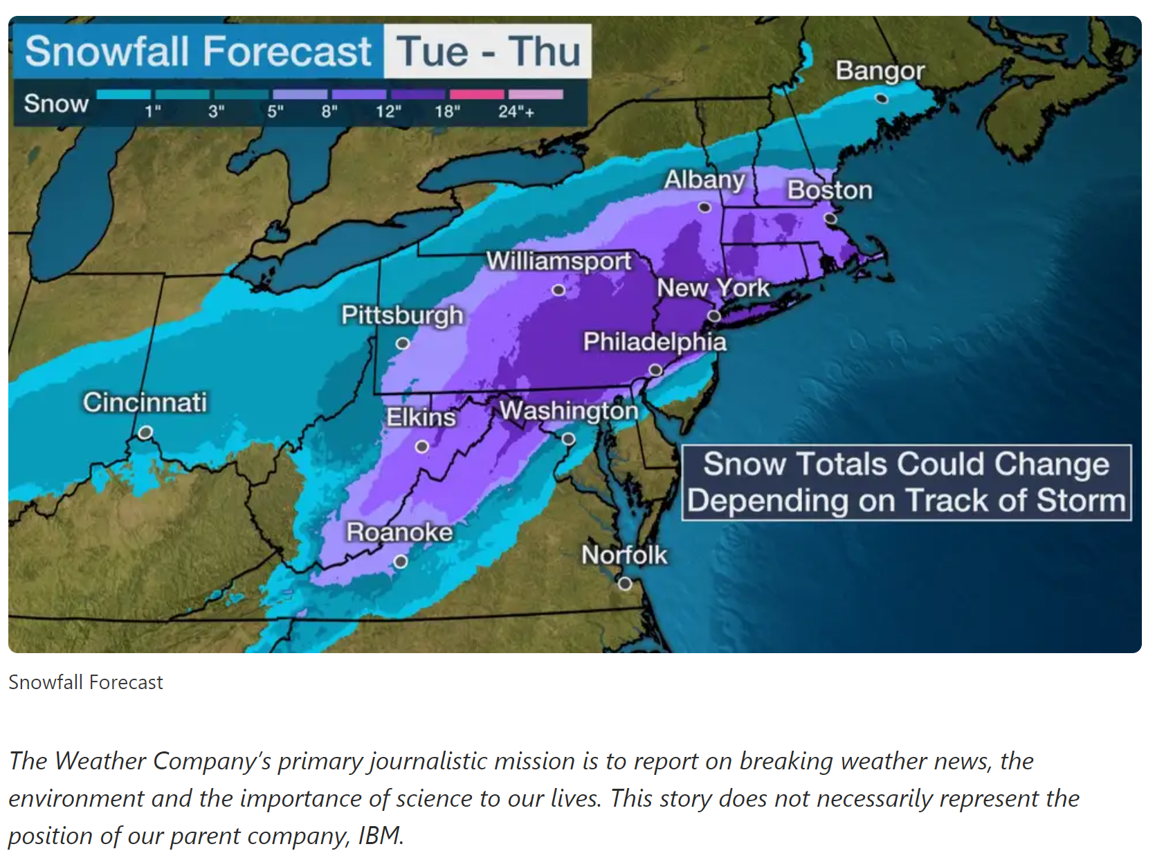
12z Euro is in and it has a slight shift south with 12-18 inches of snow over the following areas: North-Central MD, most of central and eastern PA, CNJ & NNJ, all of Connecticut, NYC, Long Island, Rhode Island, southeast Mass and Westchester, NY region. Southern NJ is mostly rain. It's currently the most aggressive of all models with the expansive snow shield.
Agreed, good call - always liked Lee Goldberg. Leaves room to go up or down if it goes either way. Pretty similar to what I was saying (roughly 8-12" for the 95 corridor).this is a good first call for now and can be adjusted as the mesoscale models come into range
Actually both the GFS is more expansive with snowfall amounts SE of 95 and the CMC is about the same - look at my post above with all 4 global models.12z Euro is in and it has a slight shift south with 12-18 inches of snow over the following areas: North-Central MD, most of central and eastern PA, CNJ & NNJ, all of Connecticut, NYC, Long Island, Rhode Island, southeast Mass and Westchester, NY region. Southern NJ is mostly rain. It's currently the most aggressive of all models with the expansive snow shield.

Lee Goldberg is no Amy Freeze.Agreed, good call - always liked Lee Goldberg. Leaves room to go up or down if it goes either way. Pretty similar to what I was saying (roughly 8-12" for the 95 corridor).

I’m supposed to fly out of Philly at 3pm on Wednesday. Odds of that happening?

Shouldn't be that heavy at 3 pm yet and it might be rain or a mix at that point, so decent chance of getting out; flights after 5-6 pm from Philly/NYC region (and especially after 8 pm) will likely see a lot of cancellations.I’m supposed to fly out of Philly at 3pm on Wednesday. Odds of that happening?

NAM starts to come aboard...still a funky warm nose in the Philly Trenton area so that will have to be ironed out
We must live very close.I agree with you. Im right on the Robbinsville/Hamilton boarder. Seems we are always at the cutoff point. I actually like the snow so will be rooting for it.
Where ya goin?I’m supposed to fly out of Philly at 3pm on Wednesday. Odds of that happening?

Yeah, cause my snowblower fired right up. Told you. 😀RGEM went north...from 40 inches last night for central jersey to 12
Where ya goin?
We want to travel but feared the overlords might stop us.
Claire; Jen and the 2 Karen(s) emphasized the masks with the thick sausage and 12" slogan were selling the best and they're almost out of stock.I was worried about Claire in July went she went AWOL but found out from other patrons she had a virus but not Covid-19. Those masks are great...little expensive but worth it. I like the little sayings on them beside the Hillsborough Deli logo. Our fish don't smell, thickest sausage in town, our bologna is round ready and right, we don't do 4" we do 12".
I think I saw Amy freeze at the Hillsborough Deli. She’s good friends with KarenMaybe he thought it was Heidi Freeze forcast.
Amy has some huge calves !Lee Goldberg is no Amy Freeze.
Updated NWS-Philly snowfall map. Still a sharp cutoff from 95 towards the coast, but starting to look like Trenton to NB to SI are in for at least a foot and up to 18".
Edit - and NWS-NYC watches up for all of NENJ/NYC/LI/SECT/LHV for the potential of 12-17" of snow...
https://forecast.weather.gov/wwamap/wwatxtget.php?cwa=phi&wwa=winter storm watch

Important PSA:
Listen up, New Jersey: Don’t trust all those wild snowfall predictions flooding social media
Listen up, New Jersey: Don’t trust all those wild snowfall predictions flooding social media
False or misleading information about snowstorms often thrives on social media. That's why weather experts say you should be careful if you see snow forecast maps from unreliable sources.www.nj.com
Claire; Jen and the 2 Karen(s) emphasized the masks with the thick sausage and 12" slogan were selling the best and they're almost out of stock.
I think I saw Amy freeze at the Hillsborough Deli. She’s good friends with Karen
I would take the detour through the home bar!You'll need to plan for this and get an early start!


