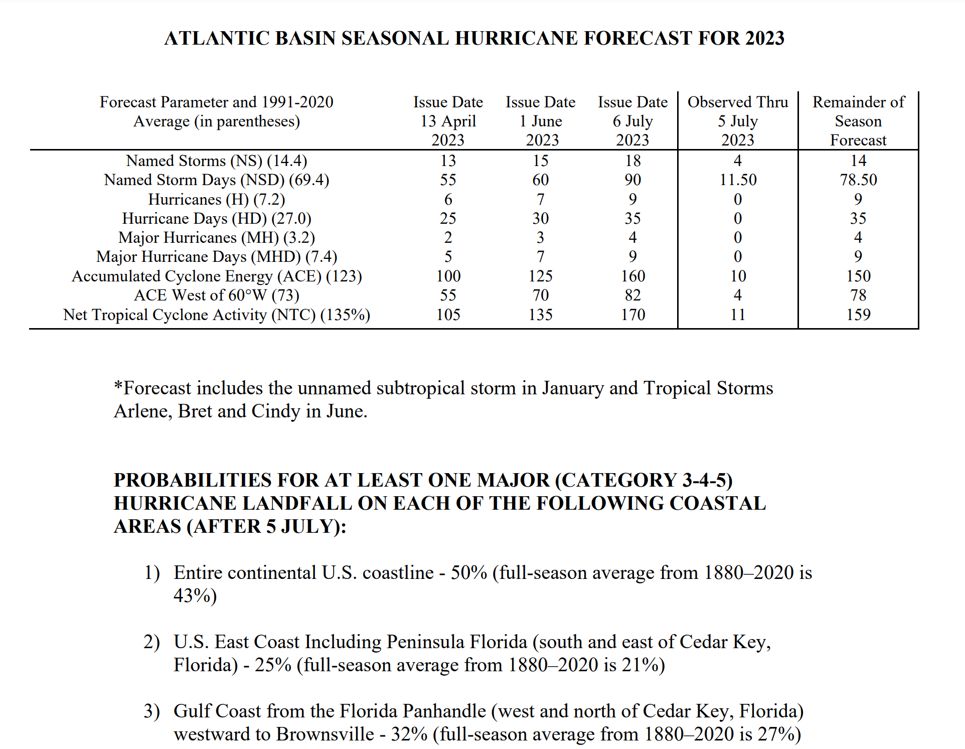
After last year's underperforming tropical season, with fairly normal activity levels, including 14 named storms, of which eight became hurricanes, and two became major hurricanes (vs. the long-term 1991-2020 averages of 14 named storms, 7 hurricanes, and 3 major hurricanes), compared to preseason forecasts for much higher activity, the recent seasonal forecasts from Colorado State (where Dr. Gray pioneered seasonal predictions, which are much more accurate than random guessing) and NOAA are for fairly normal tropical activity levels in the Atlantic Basin this year. However, note that even in a normal year, like last year, all it takes is one monster, catastrophic landfalling storm, like Ian, to make a season impactful.
CSU's prediction is for 15 named storms (vs. the 30-year average of 14.4), 7 hurricanes (7.2 avg) and 3 major hurricanes (3.2 avg), while NOAA's forecast is very similar to CSU's, with predictions of 12-17 named storms, of which 5-9 could become hurricanes, including 1-4 major hurricanes. see the graphics and links below. They do ranges, unlike CSU, but the midpoint of their ranges is reasonably close to CSU's prediction, i.e., 14.5 named storms (15 from CSU), 7 hurricanes (7 from CSU) and 2.5 major hurricanes (3 from CSU).
https://tropical.colostate.edu/Forecast/2023-06.pdf
https://www.noaa.gov/news-release/2023-atlantic-hurricane-season-outlook
https://rutgers.forums.rivals.com/t...rida-and-2022-tropical-weather-thread.241908/
Both groups use much of the same combination of analog-based forecasts (looking back at key tropical indicators, like El Nino and tropical Atlantic sea surface temps (SSTs) for past seasons with similar indicators) and forward-looking dynamical/statistical global weather models and both cite the ENSO (El Nino/Southern Oscillation indicator) state with its developing El Nino conditions (which usually means less tropical activity) and the current warmer-than-normal subtropical Atlantic SSTs (which usually means more tropical activity) as keys to their forecasts.
We'll see soon, but keep in mind that the CSU group, in particular, has been far more accurate (near 70%) with their above normal, normal, below normal predictions than simple climatological guessing would be (1 in 3, on average, if guessing). Now that @RU4Real is back, maybe he'll even have a prediction contest...
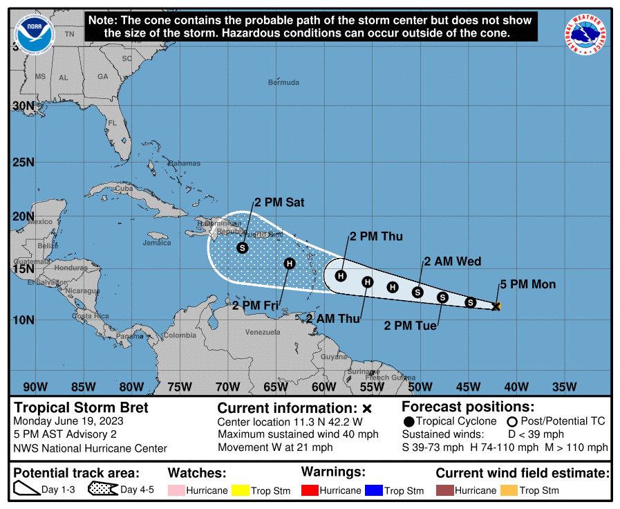
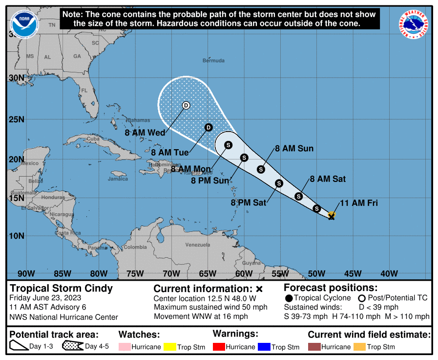
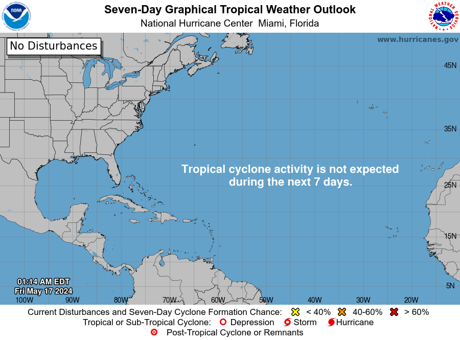
And we just had our second tropical storm of the season this past weekend with Arlene becoming a weak TS in the NE GOM with 40 mph winds for about 15 hours; this was after the NHC recently reassessed a strong January storm off the NE US coast and deemed it to have enough tropical character to be called a subtropical storm, which will remain unnamed, but still count towards the seasonal total.
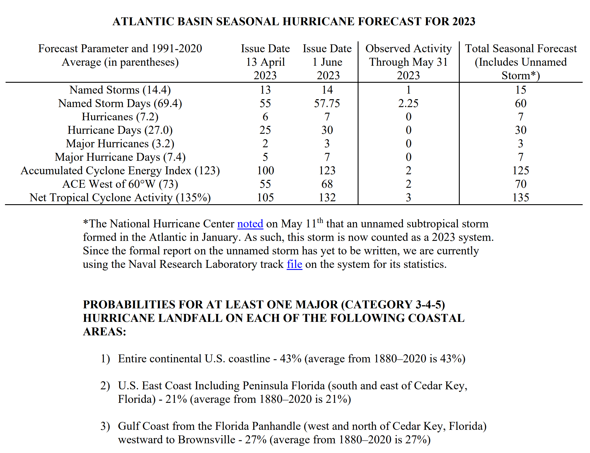
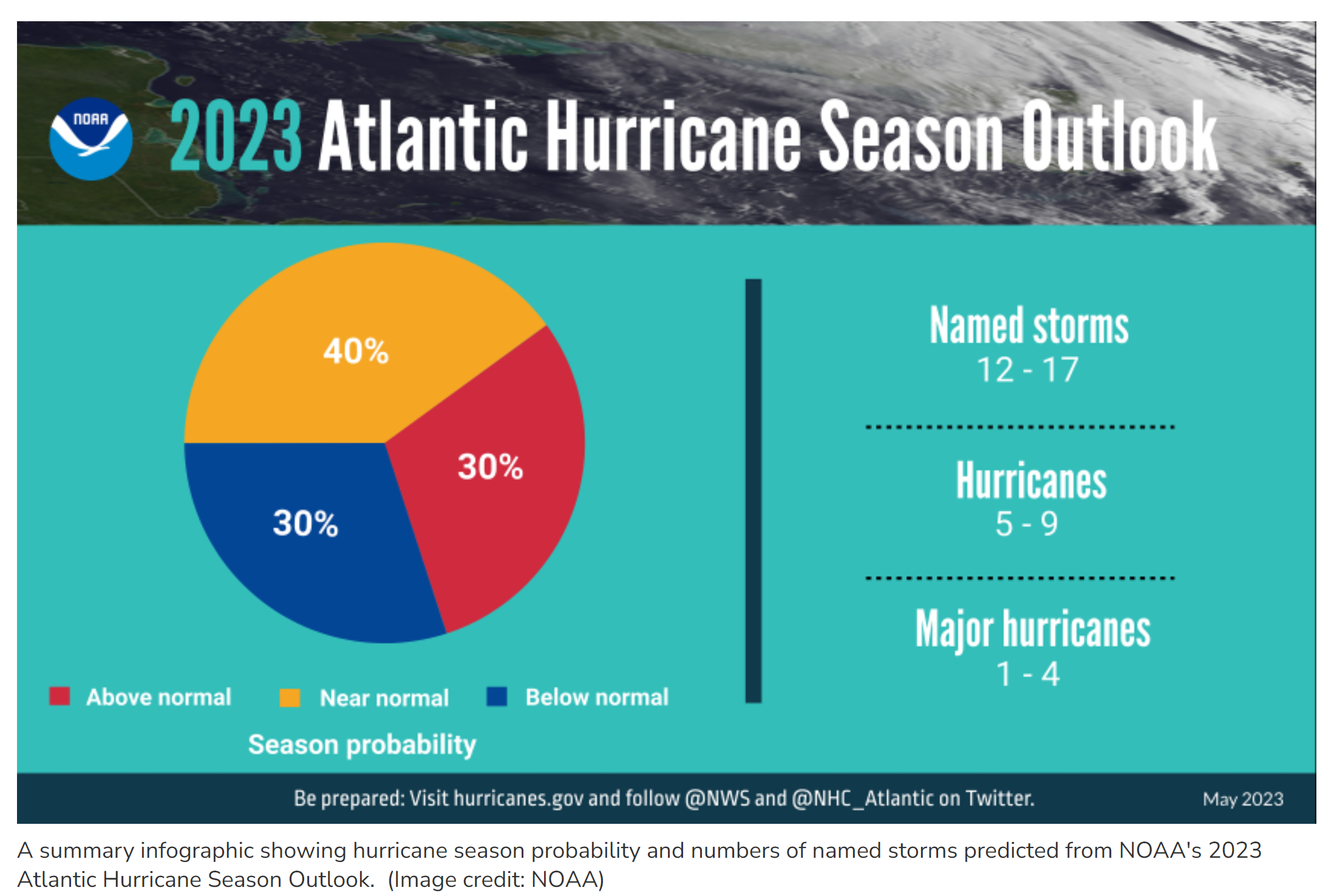
CSU's prediction is for 15 named storms (vs. the 30-year average of 14.4), 7 hurricanes (7.2 avg) and 3 major hurricanes (3.2 avg), while NOAA's forecast is very similar to CSU's, with predictions of 12-17 named storms, of which 5-9 could become hurricanes, including 1-4 major hurricanes. see the graphics and links below. They do ranges, unlike CSU, but the midpoint of their ranges is reasonably close to CSU's prediction, i.e., 14.5 named storms (15 from CSU), 7 hurricanes (7 from CSU) and 2.5 major hurricanes (3 from CSU).
https://tropical.colostate.edu/Forecast/2023-06.pdf
https://www.noaa.gov/news-release/2023-atlantic-hurricane-season-outlook
https://rutgers.forums.rivals.com/t...rida-and-2022-tropical-weather-thread.241908/
Both groups use much of the same combination of analog-based forecasts (looking back at key tropical indicators, like El Nino and tropical Atlantic sea surface temps (SSTs) for past seasons with similar indicators) and forward-looking dynamical/statistical global weather models and both cite the ENSO (El Nino/Southern Oscillation indicator) state with its developing El Nino conditions (which usually means less tropical activity) and the current warmer-than-normal subtropical Atlantic SSTs (which usually means more tropical activity) as keys to their forecasts.
We'll see soon, but keep in mind that the CSU group, in particular, has been far more accurate (near 70%) with their above normal, normal, below normal predictions than simple climatological guessing would be (1 in 3, on average, if guessing). Now that @RU4Real is back, maybe he'll even have a prediction contest...
And we just had our second tropical storm of the season this past weekend with Arlene becoming a weak TS in the NE GOM with 40 mph winds for about 15 hours; this was after the NHC recently reassessed a strong January storm off the NE US coast and deemed it to have enough tropical character to be called a subtropical storm, which will remain unnamed, but still count towards the seasonal total.
Last edited: