
Colleges
- American Athletic
- Atlantic Coast
- Big 12
- Big East
- Big Ten
- Colonial
- Conference USA
- Independents (FBS)
- Junior College
- Mountain West
- Northeast
- Pac-12
- Patriot League
- Pioneer League
- Southeastern
- Sun Belt
- Army
- Charlotte
- East Carolina
- Florida Atlantic
- Memphis
- Navy
- North Texas
- Rice
- South Florida
- Temple
- Tulane
- Tulsa
- UAB
- UTSA
- Boston College
- California
- Clemson
- Duke
- Florida State
- Georgia Tech
- Louisville
- Miami (FL)
- North Carolina
- North Carolina State
- Pittsburgh
- Southern Methodist
- Stanford
- Syracuse
- Virginia
- Virginia Tech
- Wake Forest
- Arizona
- Arizona State
- Baylor
- Brigham Young
- Cincinnati
- Colorado
- Houston
- Iowa State
- Kansas
- Kansas State
- Oklahoma State
- TCU
- Texas Tech
- UCF
- Utah
- West Virginia
- Illinois
- Indiana
- Iowa
- Maryland
- Michigan
- Michigan State
- Minnesota
- Nebraska
- Northwestern
- Ohio State
- Oregon
- Penn State
- Purdue
- Rutgers
- UCLA
- USC
- Washington
- Wisconsin
High Schools
- Illinois HS Sports
- Indiana HS Sports
- Iowa HS Sports
- Kansas HS Sports
- Michigan HS Sports
- Minnesota HS Sports
- Missouri HS Sports
- Nebraska HS Sports
- Oklahoma HS Sports
- Texas HS Hoops
- Texas HS Sports
- Wisconsin HS Sports
- Cincinnati HS Sports
- Delaware
- Maryland HS Sports
- New Jersey HS Hoops
- New Jersey HS Sports
- NYC HS Hoops
- Ohio HS Sports
- Pennsylvania HS Sports
- Virginia HS Sports
- West Virginia HS Sports
ADVERTISEMENT
You are using an out of date browser. It may not display this or other websites correctly.
You should upgrade or use an alternative browser.
You should upgrade or use an alternative browser.
OT-First day of Spring snowstorm
- Thread starter RU5781
- Start date

Wtf with that? Waste of money. And the county is run by Republicans. Aren't they supposed to be fiscal conservatives?Monmouth county already treated the arterials. I'm thinking that means "bust".
"All the afternoon models are in and we are no closer to a consensus solution. The Canadian, Euro, and high res NAM have a narrow line of 4-8 inches but it mostly falls during day and would not stick much to roads. The GFS and regular NAM show virtually nothing. To get big snow and a snow day must fall mainly at night. Still time for things to change but the window is getting smaller. New models come in tonight. Still thinking at least several inches but there is huge bust potential. Further complicating the forecast is most of the models have recently had upgrades so there is no way of knowing what their weakness or performance will be."
Why is this in quotes? Did you write this or is there a source?
Wtf with that? Waste of money. And the county is run by Republicans. Aren't they supposed to be fiscal conservatives?
It saves plowing costs pretty significantly.
Yeah, that's great when snow is IMMINENT. This state is f'd.It saves plowing costs pretty significantly.
Yeah, that's great when snow is IMMINENT. This state is f'd.
Yeah, I agree that they jumped the gun a bit. Maybe the guy in charge of MonCo roads is a Euro guy.
OR a friend of numbers or TT?Yeah, I agree that they jumped the gun a bit. Maybe the guy in charge of MonCo roads is a Euro guy.

I saw on the way home 78, 287 and 80 had all been treated.Monmouth county already treated the arterials. I'm thinking that means "bust".
Hmm.. maybe car dealerships like the rust-inducing road treatments the way the food stores like the spread of weather-related alarm-ism?
Been away since yesterday morning with no computer access, which was probably for the best, lol, as I didn't have to waste my time watching the models continue to downgrade this system, showing a more progressive, weaker system, due to later phasing of the northern and southern jet stream branch systems. That's why I always couch my posts a few to several days out with the appropriate level of uncertainty and range of outcomes, although clearly, this was a significant mid-range forecast bust, as models were showing a much more robust system 2 days ago and even yesterday morning.
The result is a system heading further offshore with less precip, with snowfall amounts now expected to be 1-2" for most on Sunday afternoon/evening, as per the maps below - and before about 5 pm, any snow that falls will likely melt, due to the indirect sunlight and even the snow that falls after that will have trouble accumulating with surface temps in the mid-30s. Could very well be a "white rain" storm with snow falling for hours (temps cold enough, aloft, for snow), but not accumulating.

The result is a system heading further offshore with less precip, with snowfall amounts now expected to be 1-2" for most on Sunday afternoon/evening, as per the maps below - and before about 5 pm, any snow that falls will likely melt, due to the indirect sunlight and even the snow that falls after that will have trouble accumulating with surface temps in the mid-30s. Could very well be a "white rain" storm with snow falling for hours (temps cold enough, aloft, for snow), but not accumulating.
A
anon_ivydyf0amkzay
Guest
Most 6Z models have nothing over the NYC metro...hardly anything over central and south jersey...NAM, NAM Hi-Res, GFS, Euro...end of week temps in the 60s sound awesome! I've even seen hints of forsythia and budding on trees...a bit early for that, but mood enhancing nonetheless!!
Most 6Z models have nothing over the NYC metro...hardly anything over central and south jersey...NAM, NAM Hi-Res, GFS, Euro...end of week temps in the 60s sound awesome! I've even seen hints of forsythia and budding on trees...a bit early for that, but mood enhancing nonetheless!!
Forsythia is out down here and many other trees/plants are budding...
They are spending money they have budgeted for snow removal, which I bet has plenty left in the till. Im sure they don't want to leave any $$$ at the end of the fiscal year.Yeah, I agree that they jumped the gun a bit. Maybe the guy in charge of MonCo roads is a Euro guy.
Leaving snow money in the budget means less for next year. It's totally unnecessary. Back in the day , I'm talking mid to late 70's,there was never all this salting and seeing blacktop 1 hr after it snowed. Our development if lucky got some sand and grit put down.
A
anon_ivydyf0amkzay
Guest
Forsythia is out down here and many other trees/plants are budding...
Here in southern NY it is usually mid to late April for the yellow stuff to come out...and I don't think it will be out since if cooled down from the past few weeks. Quite literally my favorite time of the year...past the winter doldrums, but before it gets hot; plus that beautiful shade of new green!!!
Yet we still had school. Now they pre treat, treat, and plow but school gets cancelled in a heartbeatLeaving snow money in the budget means less for next year. It's totally unnecessary. Back in the day , I'm talking mid to late 70's,there was never all this salting and seeing blacktop 1 hr after it snowed. Our development if lucky got some sand and grit put down.
This weekend starts our wedding season which will run into early November. Glad for the people getting married tomorrow the storm has fizzled out. Glad for me too.
And, of course, now some of the models are shifting back towards us, with both the Canadian and the UK models putting down 6" or more for most of the area. Euro and GFS both came a tad NW, but are still showing largely a non-event (1-2" of "falling snow" that won't accumulate). Can't make this stuff up. Unusual to have this large of a discrepancy 24-36 hours out, but not unprecedented. So, there's still a chance of some accumulating snow.
Stop....it's over jonny. Don't be a weenie and take those snow maps verbatim
I don't, but it ain't over. Models, by definition, become more accurate as one gets closer to the event. The differences between the snowy camp and the near miss camp are not that large from a meteorological perspective, where track errors of 100 miles are not unusual 24-36 hours out and that's the difference right now between the model camps. None of the models have been that great this year, so it's difficult to "know" which camp is right (figuring out which one is most likely to be correct is why some mets are better than others, but even the best can't "know" the outcome at this point).Stop....it's over jonny. Don't be a weenie and take those snow maps verbatim
Also, much of the snow would fall after about 5 pm, so accumulation would be more likely with less indirect sunlight and colder temps (still a bit above 32F though). DT/WxRisk is relatively bullish on snow for our area - at least from I-95 and SE-ward towards the coast and for NYC east through LI and eastern New England - and he declared winter dead for the coastal plain 3 weeks ago, lol. His final call snowfall map is below.

Last edited:
I don't, but it ain't over. Models, by definition, become more accurate as one gets closer to the event. The differences between the snowy camp and the near miss camp are not that large from a meteorological perspective, where track errors of 100 miles are not unusual 24-36 hours out and that's the difference right now between the model camps. None of the models have been that great this year, so it's difficult to "know" which camp is right (figuring out which one is most likely to be correct is why some mets are better than others, but even the best can't "know" the outcome at this point).
Also, much of the snow would fall after about 5 pm, so accumulation would be more likely with less indirect sunlight and colder temps (still a bit above 32F though). DT/WxRisk is relatively bullish on snow for our area and he declared winter dead for the coastal plain 3 weeks ago, lol. His final call snowfall map is below.
He hasn't been great this year.
Nope, he hasn't. Nobody has been great this year, as far as I can tell. The blizzard was nailed by the models very well from VA/NC through South Jersey, but most missed that it would also be a huge storm north of Trenton. And several of the smaller events saw a lot of last minute changes, so yeah, hard to have high confidence in any outcome. My whole point is to point out that a complete miss for the I-95 corridor is not the "given" that it seemed overnight with the 0Z models.He hasn't been great this year.
I don't, but it ain't over. Models, by definition, become more accurate as one gets closer to the event. The differences between the snowy camp and the near miss camp are not that large from a meteorological perspective, where track errors of 100 miles are not unusual 24-36 hours out and that's the difference right now between the model camps. None of the models have been that great this year, so it's difficult to "know" which camp is right (figuring out which one is most likely to be correct is why some mets are better than others, but even the best can't "know" the outcome at this point).
Also, much of the snow would fall after about 5 pm, so accumulation would be more likely with less indirect sunlight and colder temps (still a bit above 32F though). DT/WxRisk is relatively bullish on snow for our area - at least from I-95 and SE-ward towards the coast and for NYC east through LI and eastern New England - and he declared winter dead for the coastal plain 3 weeks ago, lol. His final call snowfall map is below.
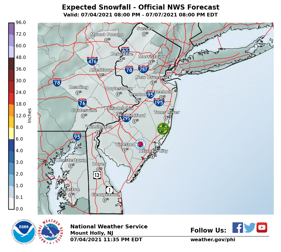
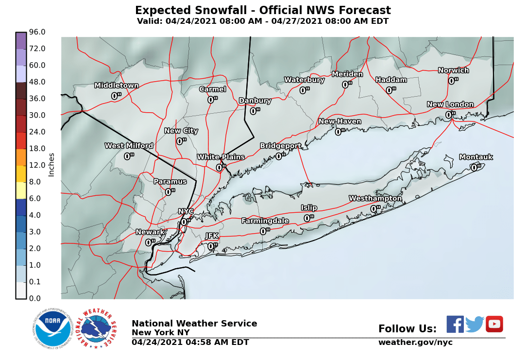
As sometimes happens, significant discrepancies exist between the NWS office in NYC and Philly, with the NYC office issuing advisories for 2-4" of snow from just east of NYC through central Suffolk County and a watch for eastern LI for 4-7" of snow; they also predict 1-2" for NYC and most of NE NJ. Usually, they correct these before issuing forecasts, but not always, especially this far in advance.
In contrast, the NWS in Philly, on their snowfall map has nowhere with more than 1", even in areas adjacent to the NYC office counties. And unlike DT's map, above, they don't have the 4-7" amounts or even the 2-4" amounts on LI extending SW into Monmouth/Ocean, which I would expect, if they were being consistent. Difficult for both to be correct, unless coastal NJ is just warm enough for mostly rain, which is possible, as it's further south and temps will be borderline. Anyway, here are the maps...
Edit: I don't usually comment on individual model runs as they come out, but the 18Z GFS just came out and is well NW of where it's been for several runs, meaning it's now predicting 2-4" for the I-95 corridor with up to 6" near the coast and for LI, similar to the Canadian and UK models. It's getting interesting again...
Last edited:
That's correct and is what I said above - not sure why the question...Correct me if im wrong but that map has one inch for our area
Dts map...and I would caution just taking snowmaps verbatim in march where we have marginal situations with temperatures and rates. I see weenies getting excited but its nyc east and LI with bigger amounts and not much of NJ
Dts map...and I would caution just taking snowmaps verbatim in march where we have marginal situations with temperatures and rates. I see weenies getting excited but its nyc east and LI with bigger amounts and not much of NJ
Gotcha - DT's map has the 2" line running right up the NJ Turnpike and to the NW of there, encompassing most of North/Central Jersey, his map says 1", but that makes no sense (can't go from 1" to 2" discontinuously), so he really meant that area as being 1-2".
NAM just made a significant move NW, too with 2-4" now for the I-95 corridor and more towards the shore. Will be interesting to see the rest of the 0Z model suite to see if we get some consensus or not. And if most of the precip falls after 5 pm and we get some decent dynamics, surface temps should get close to 32F, so melting may not be such an issue (on untreated surfaces).
As sometimes happens, significant discrepancies exist between the NWS office in NYC and Philly, with the NYC office issuing advisories for 2-4" of snow from just east of NYC through central Suffolk County and a watch for eastern LI for 4-7" of snow; they also predict 1-2" for NYC and most of NE NJ. Usually, they correct these before issuing forecasts, but not always, especially this far in advance.
In contrast, the NWS in Philly, on their snowfall map has nowhere with more than 1", even in areas adjacent to the NYC office counties. And unlike DT's map, above, they don't have the 4-7" amounts or even the 2-4" amounts on LI extending SW into Monmouth/Ocean, which I would expect, if they were being consistent. Difficult for both to be correct, unless coastal NJ is just warm enough for mostly rain, which is possible, as it's further south and temps will be borderline. Anyway, here are the maps...
Edit: I don't usually comment on individual model runs as they come out, but the 18Z GFS just came out and is well NW of where it's been for several runs, meaning it's now predicting 2-4" for the I-95 corridor with up to 6" near the coast and for LI, similar to the Canadian and UK models. It's getting interesting again...
The forecast discrepancies between the NWS offices have been addressed, fortunately. As I mentioned yesterday, the models have generally shifted back towards the NW for the storm track, meaning a moderate snowfall is now likely along the NJ TPK and points SE of there, with 1-3" likely along the NJ TPK from Philly to NYC (with the 1" amounts a bit west of the TPK and the 3" amounts a bit east of the TPK) and 3-4" likely closer to the coast (and 4-7" for eastern LI and SE New England). Areas more than maybe 15-20 miles NW of the NJ TPK should see an inch or less of snow (and maybe none at all). A little surprised Advisories haven't been issued for the coastal counties in NJ.
7 am EDIT: NWS in Philly just issued advisories for 2-4" of snow for Monmouth/Ocean/Atlantic and eastern Burlington Counties.
Rain should start in the mid/late afternoon, but should turn to snow by late afternoon as temps drop into the mid-30s - with temps that warm and the indirect sunlight, there should be little or no snow accumulation before 5-6 pm. After that, snow should accumulate during the evening, especially on non-paved, cooler surfaces and temps will drop to around 32F by late evening, allowing easier accumulation of snow, even eventually on paved surfaces, especially if the snowfall intensity is at least moderate.
The NWS snowfall maps from the Philly and NYC offices are below. Note that this is a relatively low confidence forecast, as a minor shift to the NW in the track and/or intensity of the storm (a 25-50 mile shift is still possible) could either bring the 3-4" snowfalls towards the TPK/I-95 and, alternatively, a shift to the SE could mean little to no snow near the TPK, for example.
Question: does anyone out there know how to post snowfall maps that are "permanent?" The ones most of us post are live links that update as the NWS source updates. I'm guessing one would need to save them as files, hosted somewhere.
Last edited:
Another over hyped media bust. They hype these storms past the point where all models have thrown in the towel. Tango also should be banned.
I have no clue what you're talking about. Hype has been minimal on this from all the media outlets I've watched or read on-line. We're going to see some snow on the first day of spring - that's fairly noteworthy, but nobody is saying it's that big of a deal (except maybe for eastern LI). Show me some hype...
A week ago today the media started talking about this "storm" with a chance of "significant" snowfall. That my friend is complete BS 7 days out. And again they got it wrong. Not only snow amounts but as late as Thursday they were still call this a late Saturday Sunday morning event. Whiff.I have no clue what you're talking about. Hype has been minimal on this from all the media outlets I've watched or read on-line. We're going to see some snow on the first day of spring - that's fairly noteworthy, but nobody is saying it's that big of a deal (except maybe for eastern LI). Show me some hype...
A week ago today the media started talking about this "storm" with a chance of "significant" snowfall. That my friend is complete BS 7 days out. And again they got it wrong. Not only snow amounts but as late as Thursday they were still call this a late Saturday Sunday morning event. Whiff.
And there was a chance of significant snowfall for all up until about Friday morning and then the models shifted towards a weaker, further off-shore storm. Nobody was lying - the science just isn't that good and they'll get it wrong sometimes. And every forecast I watched highlighted the uncertainty in the forecast. And I don't recall anyone talking about this being a Saturday night event - has always been a Sunday into Monday event - at most, the timeframe shifted about 6 hours later over the past couple of days. I think you just like to complain.
The media hyped this up since last Monday. It really went into full swing about Wednesday as all media outlets this was their main headline. Some mets were calling for up to 14 inches and by Friday it was 4-6.
I think you like to protect the media and all weather weenies. You know and most people should know that calling for significant snow 7 days out is just stupid and only focusing on the worst case scenario. The more likely scenario all along is exactly what we are getting. Basically nothing. The most likely scenario all along was a nucience snow in some parts. But you and Tango go and post maps and defend the most unlikely scenario. Not because you know the science but it's because it's what you want. That my friend is hype, pure and simple.And there was a chance of significant snowfall for all up until about Friday morning and then the models shifted towards a weaker, further off-shore storm. Nobody was lying - the science just isn't that good and they'll get it wrong sometimes. And every forecast I watched highlighted the uncertainty in the forecast. And I don't recall anyone talking about this being a Saturday night event - has always been a Sunday into Monday event - at most, the timeframe shifted about 6 hours later over the past couple of days. I think you just like to complain.
Forecasting that is biased to help TV ratings or in your case because you love terrible storms is not forecasting.
The storm was "hyped" originally by Patch.com but if that is where people get their news they really should find something else to read. Patch lives and dies with sensational headlines to drive clicks. It's basically a glorified blog run by folks across the country.
I never saw any newspapers really hyping the storm at all.
I never saw any newspapers really hyping the storm at all.
Now you're just lying. Show me one map I posted showing a worst case scenario. Oh that's right, you can't. The most likely scenario 3-4 days out was a significant snowfall, but I didn't post any of those maps, because I knew the uncertainty was high, as I said in every post. First map I posted was the general 3-6" snowfall maps from the NWS on Friday morning and here's what I said in that post:I think you like to protect the media and all weather weenies. You know and most people should know that calling for significant snow 7 days out is just stupid and only focusing on the worst case scenario. The more likely scenario all along is exactly what we are getting. Basically nothing. The most likely scenario all along was a nucience snow in some parts. But you and Tango go and post maps and defend the most unlikely scenario. Not because you know the science but it's because it's what you want. That my friend is hype, pure and simple.
Forecasting that is biased to help TV ratings or in your case because you love terrible storms is not forecasting.
"I'd say we're almost certainly going to get at least an inch or two of snow and are likely to get several inches of snow, but the big snowfalls are looking less likely; no snow is very unlikely."
Seems pretty reasonable to me and is pretty close to where we are now, pretty much - maybe just a tad over that, but not by much. You've repeatedly shown you don't know dick about meteorology and I know I'm not an expert, but I know a shit-ton more than you and 99% of the general public.
Similar threads
- Replies
- 60
- Views
- 1K
- Replies
- 152
- Views
- 7K
- Replies
- 2
- Views
- 284
- Replies
- 9
- Views
- 685
ADVERTISEMENT
ADVERTISEMENT