ADVERTISEMENT

OT: First winter storm end of week?

Status
Not open for further replies.
Lol! Tell her to wake up my son. He’s actually in central 6th. Had to stay the night too.

Haha - she is at Roosevelt.
Police were taking the last 4 kids at 8:50.
She got home around 9:15.

Hope your son had a good night - considering the circumstances.
 
I live right next to where the accident was.
Was on the 506 train from Hoboken to Gladstone. I live around the corner from Murray Hill train station.

We got stopped at Summit around 6:30. After about 10 minutes they let our train go 2 stops to New Prov and MH before turning back and returning to Summit.

Union Ave is the next train track crossing so trains couldnt go past MH station.

My house backs onto Union Ave up the hill. I wasn't home yet, but the wife heard all the emergency vehicles rushing to the scene.
 
It's about time somebody took somebody to task. It was eerily quiet from the people in charge between the hours of 3 and 10 yesterday. I mean I don't even like Christie, but recognize that he tries to thrive in emergency situations. I talked to a snow plow guy at the bagel shop this morning and he had to plow around rt 80 for DOT and said that they were told to go out at least an hour later than they should've been. Amazing

Even with the equipment going out late, how much agita would have been avoided if Murphy at noon or 1PM had done the equivalent of:

"I'm seeing pictures of people still on the beach. Get the hell off the beach and go home."

Christie had his faults, but dealing with emergencies wasn't one of them,.
 
you cannot plow what is not there...plows just do not appear out of thin air...there has to be a certain amount before they can serve their purpose....there was no snow at 1 in many of those locations...how about people in those areas should not have gone to work and clogged up the roads. In the West Orange case, its inexcusable given the forecasts that they did not give an early dismissal. The event started from noon to 2 and already people were bitching about seeing now plows

Most snowfall is at night when everyone is sleeping..either safely home from work or overnight or if its snowing the next day, everyone stays home. This was one of those events hitting at the worst possible time because everyone based on the METS forecast decided to give it a go and go into work. Then they flooded the roads, simple as that.

I will assume but I dont know for sure that some municipalities may not have had any salt supplies or money in the budget for more and perhaps given the forecast of a minor type event that would turn to rain decided to tough it out. The state itself should have plenty of resources to pull from.

I live in Old Tappan and drive into the West Village twice a day. My gripe is not about plows but rather the lack or brining prior to the expected start of precipitation. I do understand most storms happen overnight, but it doesn't mean that mid-day storms are so rare that we don't know how to prepare for them. I did not see one line of brine on any of the roads during the day. The city generally salts early but tend not to have much issue with ice as they equip their buses with chains early if they are prepared.

If you brine early enough it can be enough to keep a wet road wet and not icy as cars continue to drive over it without snow or sleet in their treads. This is a fact. The brine would have done enough for at least an hour for response times to be shortened and less vehicles clogging up the main pathways due to multi-lane vehicle blockages.

When I write about the plows it was in regards to last year's early storm which ended up being only an inch or so of sleet. They didn't prep then either but they also didn't send plows out to much later after the fact. I saw nothing plowed on the NJ Turnpike at 4 PM that day. Luckily there were not many vehicles on the road at the time altough i know that rt 80 was a nightmare. But i knew that if this same thing was to happen again it could be much worse. After 20 years of driving through snowy weather at all times of the day, I know what to expect. Even for a light dusting, most of our municipalities brine the road. Even if there's no snow in the forecast but the low is forecast in the single digits, they brine the road. But all this is done starting in December.

I know you guys read the discussions and look at the maps, but I do my checking by putting in my zip codes and reading the day and night forecasts as they tell what time most of the precipitation will end. I don't take as gospel, but I use it to get a general idea of what I might expect. And for my area and nyc, I was a little surprised to see not much of a difference in the high range of accumulation. Thursday was 1- 2.5 for OT and 1- 1.5 for NYC. Thursday night was 1-3 for OT and 1- 2.5 for nyc. The thursday night said most snow was expected before 8 PM. The day forecast said mostly after 1 pm after saying after noon on monday and tuesday. In my experience, NYC generally shows half the amount of accumulation forecasted than OT. I was surprised to see that it was only off by an inch. And like I said even DT's final call band had me in the 4 to 7 range with nyc in the lower band but right at the border of it.
 
Not for me. I checked both for bergen county and nyc and both said up to 4 inches on Wednesday night. I saw it up to 5 inches earlier in the day Wednesday. If you look up specific zip codes they actually give you different amounts. I was checking every hour for two zip codes for three days straight. It started as up to 1 inch then gradually moved up to 2 inches on tuedsay. On wednesday night it jumped up again. NYC I saw anywhere from 1 - 3" with it peaking at 4 the night before. In my town, it read up to 5 or 6" and we are not inland towards the northwest. At any rate, if it says 1 - 3" for during the day it means between the time they say it starts (around 1 pm) to 7 pm. Not as bad but definitely enough to cause problems during rush hour. They usually get started before noon when the forecast says it will start around 1 PM. And the snow started closer to 2 pm a full hour later.

Read my posts in this thread. You're completely wrong on NYC/LI/Hudson. NWS-NYC did NOT forecast more than 1-2" of snow/sleet for NYC/LI/Hudson County until Thursday at 12:45 pm, when they first issued Winter Weather Advisories for those locations for 2-5" of snow (they had advisories up for most of NE NJ - Essex/Union/Passaic/Bergen - since Weds at 4 pm for 1-3"). The NWS in Philly issued advisories up for the 95-corridor from DE to Middlesex/Somerset on Wednesday at 4 pm for 1-3" of snow, at least north of Trenton. .

The NWS didn't go "all-in" on this being a significant snowstorm for the 95 corridor from Philly to NYC until about noon yesterday (and 12:45 pm for NYC/LI), hours after there were strong indications the storm was overperforming from DC to DE and despite the best models consistently showing a major snowstorm. Major fail by the NWS - and every media outlet I know of in the region. As I said last night, DT was the only source I saw that had the 95 corridor with more than 1-2" on Wednesday night.

Having said all that, with the upgrade by the NWS and others around 12-1 pm yesterday, it's still an epic fail by the State/County/Local governments to not mobilize by 2 pm to get out ahead of the snow, which started falling in earnest around 1 pm for most of CNJ at least and 2 pm for NYC (and you need to have ~2" snow to even start plowing). I have no idea why there were reports of now plows or salt trucks during most of the afternoon.

Also, for areas NW of 95, where advisories were in place since Wednesday for 1-3/2-4", I am astounded they weren't plowing/salting roads like 280/80/287/Parkway etc. in NNJ from the get go. Yes, the traffic made things a lot harder as people left work early, but if they had been massively plowing/salting starting around 2 pm, I'm sure things would've at least been better. Same thing in NYC, although that's a harder one, given there's always traffic and 1-2" per hour snowfall is just really hard to stay ahead of.

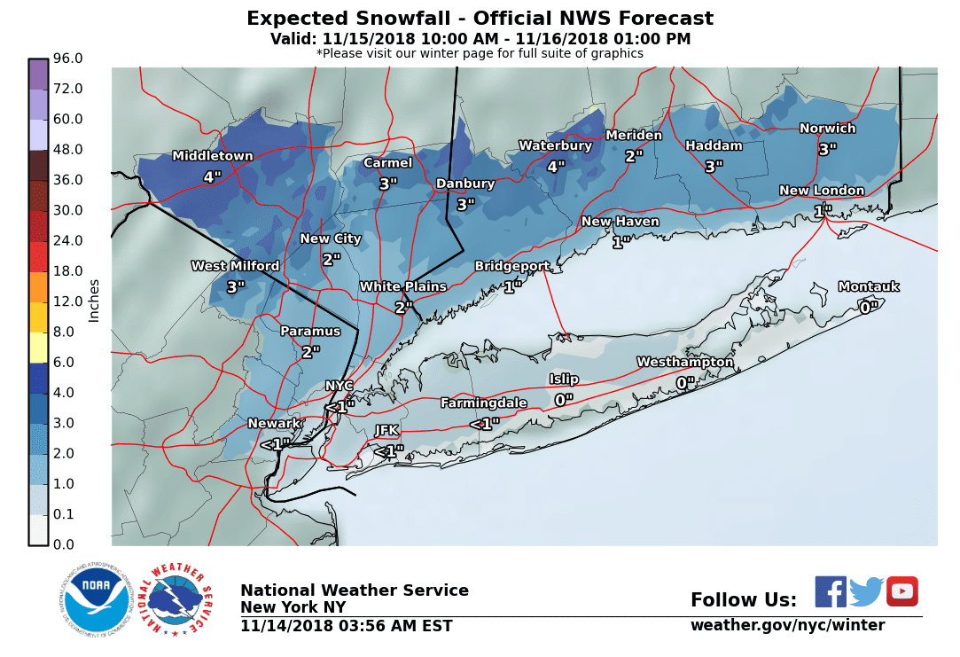
Here's the 12:45 pm NWS-NYC update where they issued advisories for NYC/LI/Hudson County for the first time.

National Weather Service New York NY
1245 PM EST Thu Nov 15 2018

NEAR TERM /THROUGH TONIGHT/...

Significant update based on latest radar trend snowing hand of
heavier precip developing from DC metro to southern NJ, which
high resolution guidance including the NAM/HRRR/RAP bring into
the area during late afternoon and earlier evening. Despite
easterly flow, temps upstream along the south coast of New
England were in the mid 30s with dewpoints in the lower 20s, so
do not expect too much in the way of maritime moderation at
least into this evening. So the overall trend is for colder and
snowier going into early this evening. NAM may be a bit too
cold in the blyr, but we also started out the day with lower
dewpoints and so greater potential for temps to crash close to
freezing with onset of steady precip this afternoon. Period of
steady snow looks to be heavier and of longer duration than
initially expected, and warmer air aloft does not look to make
it in until about 23Z-00Z around NYC, and to interior sections
til late evening.

With the above in mind, issued winter storm warnings for the
interior where snowfall amounts have been bumped up into the
4-8 inch range, and winter wx advisories have been extended
into NYC and Long Island for 2-5 inch snowfall, with the higher
amounts generally farther away from the immediate coast. Also
bumped up amts along the CT coastline, and the coastal zones
could see some 6-inch amounts north of I-95. Timing of snow in
most places should cause significant disruptions to the
evening commute.
 
Last edited:
Woah be me. Your sister and all complaining should try living in a midsize Toyota like I've been since October 27th . Actually in lucky i estimate hundreds living on the street and homeless just in the small Somerville area alone. There are many living in the train stations up both the Raritan valley and Northeast corridor lines. If sis is into the golden shower thing i oft have plenty of time in the overnight...

If

Post of the Year.
 
I wonder if it hurt the response that the New Jersey State League of Municipalities Conference was going on in Atlantic City from Tuesday through Thursday? Lack of leadership on the home front this week?
 
My house backs onto Union Ave up the hill. I wasn't home yet, but the wife heard all the emergency vehicles rushing to the scene.

Yikes. Awful.

I'm on Sagamore right across from train tracks.
Able to walk from MH station.

Luckily my wife picked up kids from daycare at 2pm before it all really started.
 
Read my posts in this thread. You're completely wrong. NWS-NYC did NOT forecast more than 1-2" of snow/sleet for NYC/LI/Hudson County until Thursday at 12:45 pm, when they first issued Winter Weather Advisories for those locations for 2-5" of snow (they had advisories up for most of NE NJ - Essex/Union/Passaic/Bergen - since Weds at 4 pm). The NWS in Philly issued advisories up for the 95-corridor from DE to Middlesex/Somerset on Wednesday at 4 pm for 1-3" of snow, at least north of Trenton. .

The NWS didn't go "all-in" on this being a significant snowstorm for the 95 corridor from Philly to NYC until about noon yesterday (and 12:45 pm for NYC/LI), hours after there were strong indications the storm was overperforming from DC to DE and despite the best models consistently showing a major snowstorm. Major fail by the NWS - and every media outlet I know of in the region.

Having said all that, with the upgrade by the NWS and others around 12-1 pm yesterday, it's still an epic fail by the State/County/Local governments to not mobilize by 2 pm to get out ahead of the snow, which started falling in earnest around 1 pm for most of CNJ at least and 2 pm for NYC. I have no idea why there were reports of now plows or salt trucks during most of the afternoon.

Also, for areas NW of 95, where advisories were in place since Wednesday for 1-3/2-4", I am astounded they weren't plowing/salting roads like 280/80/287/Parkway etc. in NNJ from the get go. Yes, the traffic made things a lot harder as people left work early, but if they had been massively plowing/salting starting around 2 pm, I'm sure things would've at least been better. Same thing in NYC, although that's a harder one, given there's always traffic and 1-2" per hour snowfall is just really hard to stay ahead of.

Well we will have to disagree then because I know what I read and saw. You are getting your numbers from the disco, I am reading the descriptions on the weather page. I am not lying. That's exactly what it said. It doesn't mean they were all-in. I mean how many zip codes do you actually put into the search box? Every zip code shows different things despite being located in the same NWS office. I don't read the disco so I don't use this as my final be all, although if I was technical enough about it, I would. I read the other stuff because it is something that is out there that can happen and it's from NWS, so... Did you look at DT's final call map? It was pretty bullish.

I do agree that it was a MASSIVE failure.
 
Even with the equipment going out late, how much agita would have been avoided if Murphy at noon or 1PM had done the equivalent of:

"I'm seeing pictures of people still on the beach. Get the hell off the beach and go home."

Christie had his faults, but dealing with emergencies wasn't one of them,.
Murphy was told of the storm, his answer was where is my pot, see
ya don't want to be ya.
 
Haha - she is at Roosevelt.
Police were taking the last 4 kids at 8:50.
She got home around 9:15.

Hope your son had a good night - considering the circumstances.

He got home around 9am. Wife had to go pick him up because the buses still weren't there, not sure what happened with that but don't care at this point.

Daughter is at Roosevelt. She was able to get on one of the first buses out of there but spent 5hrs on the bus. She still got home before me. Ha.

As long as everyone is safe that is all that matters at this point.
 
Well we will have to disagree then because I know what I read and saw. You are getting your numbers from the disco, I am reading the descriptions on the weather page. I am not lying. That's exactly what it said. It doesn't mean they were all-in. I mean how many zip codes do you actually put into the search box? Every zip code shows different things despite being located in the same NWS office. I don't read the disco so I don't use this as my final be all, although if I was technical enough about it, I would. I read the other stuff because it is something that is out there that can happen and it's from NWS, so... Did you look at DT's final call map? It was pretty bullish.

I do agree that it was a MASSIVE failure.

We agree on this being a massive NWS/media meteorological failure. However, there is no "agree to disagree" on the NWS-NYC and issuing advisories for NYC/LI/Hudson. They didn't until 12:45 pm yesterday and the vast majority of people look at the NWS home page map and when they don't see the blue color for a WWA, they likely don't go any further, thinking the storm is no big deal.

In addition, their snowfall maps, which some get their info from, which I posted Weds and at 5:45 am yesterday, were showing 1" or less for Newark, Manhattan and JFK. The updated map (with 3-7" snow for the whole NYC metro area) wasn't posted by the NWS until 1:15 pm yesterday. And I also click all around the various locations everywhere in the area and never saw a forecast for more than 1-2" for anywhere in that area until 12:45 pm - they can be wonky though, so perhaps you saw something else, but I think most who go to the NWS site look at the county map and the snowfall map for quick info.

And yes, I posted DTs map Wednesday night and have talked about it a lot in this thread, as he's the only source I saw showing more than 2" (2-4") for the 95 corridor from Philly to NYC (and he had 4-7" for NW of there). I even congratulated him on his FB site.
 
No I only get aggravated when someone argues with me on how much snow I got when they are 50 miles away and I'm standing here.
My biggest complaint is never the forecasts on here, it is the hype of the media.

I agree with you about measuring snow, but it's best to rely on trained spotters if possible.

To me, forecasts are hyped when the weather person makes a prediction that calls for much more snow than the NWS forecasts. Do you find that all of the Philly stations do this?
 
So we cleared off around 7" of snow by 9-9:30 last night, and precipitation had stopped at that point. Imagine our surprise waking up to find another 1.5" of heavy wet stuff had fallen and needed to be cleaned off. So we ended up with around 8.5" total for the storm.

In addition, their snowfall maps, which some get their info from, which I posted Weds and at 5:45 am yesterday, were showing 1" or less for Newark, Manhattan and JFK. The updated map (with 3-7" snow for the whole NYC metro area) wasn't posted by the NWS until 1:15 pm yesterday. And I also click all around the various locations everywhere in the area and never saw a forecast for more than 1-2" for anywhere in that area until 12:45 pm - they can be wonky though, so perhaps you saw something else, but I think most who go to the NWS site look at the county map and the snowfall map for quick info.
Yep, this was pretty much the map I was seeing on NWS until at least late morning yesterday:

u1OeXVe.png


Perhaps even later, I remember seeing the numbers change in our area to 7" in the early afternoon hours.
 
So we cleared off around 7" of snow by 9-9:30 last night, and precipitation had stopped at that point. Imagine our surprise waking up to find another 1.5" of heavy wet stuff had fallen and needed to be cleaned off. So we ended up with around 8.5" total for the storm.


Yep, this was pretty much the map I was seeing on NWS until at least late morning yesterday:

u1OeXVe.png


Perhaps even later, I remember seeing the numbers change in our area to 7" in the early afternoon hours.

At least down here, the weather people on the networks were forecasting that late dump of snow.I don't think it got us in South Jersey, where the roads and sidewalks are clear.
 
do meterologists and weather forcasters get paid or do they do it for free

But how talented are the models they have to work with?
You can't expect them to overcome lesser ttalented models - regardless of how much they are being paid.....

Just trying to add some levity.
 
  • Like
Reactions: retired711
BTW, I know Rutgers did not close the Camden campus yesterday -- meaning the secretaries had a hell of a time getting home -- but I don't know about the others. I do know that the Newark campus is closed today.
 
At least down here, the weather people on the networks were forecasting that late dump of snow.I don't think it got us in South Jersey, where the roads and sidewalks are clear.

The overnight dump of snow on the backend of the departing low was reasonably well forecast by most sources yesterday, as they were calling for a quick inch or two between 5-8 am, mostly N of 78 and W of the Parkway. We just got some flurries in the 95-corridor, but many reports of an inch or so to the N/W, especially N of 80.
 
That's why I asked you about your work predictions - which you are paid to make. BTW,, your logic suggests you should stop carping about RU#'s posts -- he's not getting paid either.


Totally idiotic post. When we or anyone else **** up at work there are heavy consequences
 
Totally idiotic post. When we or anyone else **** up at work there are heavy consequences

There's a difference between ****ing up and just making a prediction that doesn't work out. There are lots of uncertainties in life. As someone said, predictions are difficult, especially about the future.
 
their prediction is their job..what are you missing...literally millions in this area rely on it...its not some remote area in South Dakota

I do not make predictions at work so I dont know why you keep bringing predictions up of other people...
 
I agree with you about measuring snow, but it's best to rely on trained spotters if possible.

To me, forecasts are hyped when the weather person makes a prediction that calls for much more snow than the NWS forecasts. Do you find that all of the Philly stations do this?
Mostly but the weekend guy on Channel 6, Chris Sowers, does not play the hype game which is probably why he is on weekends. Easily the best Meteorologist in Philly. And I can't speak about Fox. The morning crew is awful.
 
I see a lot of blame going on around here. Clearly the NWS, who's job it is to provide us with all the information, failed. Calling out Govs and Mayors is hysterical. It really is.
I also find one group that hasn't been blamed. The drivers who think having 4 wheel drive means they can still go 80mph. And end up taking out a complete highway full of cars and closing the roads.
 
  • Like
Reactions: retired711
So we cleared off around 7" of snow by 9-9:30 last night, and precipitation had stopped at that point. Imagine our surprise waking up to find another 1.5" of heavy wet stuff had fallen and needed to be cleaned off. So we ended up with around 8.5" total for the storm.


Yep, this was pretty much the map I was seeing on NWS until at least late morning yesterday:

u1OeXVe.png


Perhaps even later, I remember seeing the numbers change in our area to 7" in the early afternoon hours.

Spanky - I know we talked about this awhile back, but somehow your NWS graphics are still "correct" from this storm a year ago, while all of the ones I pasted (from my Facebook account) are showing those dreaded boxes with the X through them in this thread and other weather threads (especially the NWS graphics). Oddly enough, all of the weather graphics from the NHC and other places (which I also paste to FB and then copy here) seem to still be fine in the link below.

https://rutgers.forums.rivals.com/t...-mid-sept-now-jerry-karen-and-lorenzo.173524/

https://rutgers.forums.rivals.com/t...d-threat-and-sunny-dry-cool-for-ru-iu.176413/

Partly wondering if it's a time thing for me, since this thread is a year old and I don't see the graphics any more, whereas the hurricane thread above is only a few months old. But I see mixtures of graphics that are still ok in older threads and graphics that aren't (like the one below). Maybe it's a graphic type issue. No clue. Any insight here?

https://rutgers.forums.rivals.com/t...this-afternoon-thru-tues-am-7-22-7-23.170370/
 
Spanky - I know we talked about this awhile back, but somehow your NWS graphics are still "correct" from this storm a year ago, while all of the ones I pasted (from my Facebook account) are showing those dreaded boxes with the X through them in this thread and other weather threads (especially the NWS graphics).
That's because I download the graphic to a native file, then stuff it into my imgur.com account. I got tired of posting the NWS graphic and not being able to track the changes in their forecasted amounts.
 
That's because I download the graphic to a native file, then stuff it into my imgur.com account. I got tired of posting the NWS graphic and not being able to track the changes in their forecasted amounts.

I recall trying to do that and it kept not working. Any chance you can explain how to do this as if I'm an 8-year old (or, actually, a 57-year old)? Thanks!
 
I recall trying to do that and it kept not working. Any chance you can explain how to do this as if I'm an 8-year old (or, actually, a 57-year old)? Thanks!
1. Right click on the graphic you want to save, select "Save image as..." and save it to your drive.
2. You will need an account to host this on this new interwebz thingie, I'd recommend imgur.com because they don't limit you on hotlinking images. I used to use Photobucket, which has a better interface, but they now throttle hotlinking. But imgur, Photobucket, Shutterfly, etc - get an account on one of those.
3. Upload your image to your account.
4. Hotlink the image (i.e., paste the URL) wherever you want to use it.
 
  • Like
Reactions: RU848789
Status
Not open for further replies.
ADVERTISEMENT
ADVERTISEMENT