Maybe...but I'd like to know how one of us gave birth to our son...Are you my... father?
Colleges
- American Athletic
- Atlantic Coast
- Big 12
- Big East
- Big Ten
- Colonial
- Conference USA
- Independents (FBS)
- Junior College
- Mountain West
- Northeast
- Pac-12
- Patriot League
- Pioneer League
- Southeastern
- Sun Belt
- Army
- Charlotte
- East Carolina
- Florida Atlantic
- Memphis
- Navy
- North Texas
- Rice
- South Florida
- Temple
- Tulane
- Tulsa
- UAB
- UTSA
- Boston College
- California
- Clemson
- Duke
- Florida State
- Georgia Tech
- Louisville
- Miami (FL)
- North Carolina
- North Carolina State
- Pittsburgh
- Southern Methodist
- Stanford
- Syracuse
- Virginia
- Virginia Tech
- Wake Forest
- Arizona
- Arizona State
- Baylor
- Brigham Young
- Cincinnati
- Colorado
- Houston
- Iowa State
- Kansas
- Kansas State
- Oklahoma State
- TCU
- Texas Tech
- UCF
- Utah
- West Virginia
- Illinois
- Indiana
- Iowa
- Maryland
- Michigan
- Michigan State
- Minnesota
- Nebraska
- Northwestern
- Ohio State
- Oregon
- Penn State
- Purdue
- Rutgers
- UCLA
- USC
- Washington
- Wisconsin
High Schools
- Illinois HS Sports
- Indiana HS Sports
- Iowa HS Sports
- Kansas HS Sports
- Michigan HS Sports
- Minnesota HS Sports
- Missouri HS Sports
- Nebraska HS Sports
- Oklahoma HS Sports
- Texas HS Hoops
- Texas HS Sports
- Wisconsin HS Sports
- Cincinnati HS Sports
- Delaware
- Maryland HS Sports
- New Jersey HS Hoops
- New Jersey HS Sports
- NYC HS Hoops
- Ohio HS Sports
- Pennsylvania HS Sports
- Virginia HS Sports
- West Virginia HS Sports
ADVERTISEMENT
You are using an out of date browser. It may not display this or other websites correctly.
You should upgrade or use an alternative browser.
You should upgrade or use an alternative browser.
OT: Hurricane Ian to Bring Major to Catastrophic Impacts to Cuba/Florida (and 2022 Tropical Weather Thread):
- Thread starter RU848789
- Start date
Tropics remaining active, as TD-12 just formed near Africa, but is no risk to land and will likely dissipate in a couple of days, while the
https://www.nhc.noaa.gov/gtwo.php?basin=atlc&fdays=5
Tropics remaining active, as TD-12 just formed near Africa, but is no risk to land and will likely dissipate in a couple of days, while the tropical wave nearing the Caribbean is looking more vigorous and it could form a TS in the next few days (not a given though), although the steering pattern will likely keep this one moving mostly westward into Central America (large high pressure in the SW Atlantic). Still needs to be watched as it could become a hurricane and it's possible it could move northward towards the Gulf eventually (even if after hitting CA or the Yucatan).A tropical wave nearing the Leeward Islands and the Caribbean has the potential to become our next named storm, although formation is not a given. If it does form, it would be taking a track similar to Ian's track, at least into the Caribbean - beyond that is anyone's guess. And we might get another named system in the next few days not far from the Cape Verde Islands, but this storm is unlikely to pose any threat to land.
https://www.nhc.noaa.gov/gtwo.php?basin=atlc&fdays=5
https://www.nhc.noaa.gov/gtwo.php?basin=atlc&fdays=5
Thank you so much!Orlando had major flooding from 10-15" rains and significant wind damage, also, from Cat 1 hurricane force wind gusts.
https://www.wesh.com/article/rainfall-totals-hurricane-ian/41494992
https://www.wesh.com/article/hurricane-ian-flooding-orlando/41453236
Negative on the 96 hour radar composite. Every site is pushing on "futurecast radar" but nobody has the storage & bandwidth to host 4-7 day radar loops. Another item for the "When I Win The Powerball" bucket.The one saving grace with all the rain in our area has been that it's fallen over 3+ days, meaning urban and river flooding has been minimal, as that is often a function of heavy rain over a short period of time. In fact, I'd call it a blessing for most as we've been able to put a huge dent in the statewide drought (except N of 80, where generally only 1-2" of rain has fallen) with this rain without producing much flooding. Hey - I use that same radar composite rainfall site, but wish it had historical views (it's only up to the current time, up to 72 hours) - do you know of a site that has 3-4 day radar composites for any timeframe for any location? For example, I'd love to look back at this for Florida during Ian. I forgot to save the graphic from a few days ago. TIA.
TD-12, near Africa, looks like it's going to peter out before becoming a named TS, which also happened to TD-11. So for all you hurricane conspiracy theorists, clearly the NHC isn't trying to stack the deck with spurious storms. They just use the best science they can in determining whether storms qualify to be named.Tropics remaining active, as TD-12 just formed near Africa, but is no risk to land and will likely dissipate in a couple of days, while the
Tropics remaining active, as TD-12 just formed near Africa, but is no risk to land and will likely dissipate in a couple of days, while the tropical wave nearing the Caribbean is looking more vigorous and it could form a TS in the next few days (not a given though), although the steering pattern will likely keep this one moving mostly westward into Central America (large high pressure in the SW Atlantic). Still needs to be watched as it could become a hurricane and it's possible it could move northward towards the Gulf eventually (even if after hitting CA or the Yucatan).
https://www.nhc.noaa.gov/gtwo.php?basin=atlc&fdays=5
And the wave moving through the southern Windward Islands and into the Caribbean still looks like it will become a TS in the next few days, especially as it gets towards the western Caribbean, where conditions are very conducive for development. Fortunately, with steering winds out of the east, the system should move towards Nicaragua/Honduras around Day 5 and even if it's not a powerful storm, heavy rains in those countries often lead to mudslides and flooding. This system is very unlikely to turn north towards the GOM/US.
https://www.nhc.noaa.gov/gtwo.php?basin=atlc&fdays=5
TD-12 did peter out before becoming a named storm and the tropical depression in the Caribbean, which brought flooding rains to Venezuela yesterday, was just upgraded to a tropical storm, Julia, which is forecast to strengthen to a Cat 1 hurricane before landfall on Sunday in Nicaragua. There will likely be catastrophic rainfall and flooding with mudslides in the mountains. Fortunately for the US, the storm should be steered west and dissipate over interior Central America or Mexico.TD-12, near Africa, looks like it's going to peter out before becoming a named TS, which also happened to TD-11. So for all you hurricane conspiracy theorists, clearly the NHC isn't trying to stack the deck with spurious storms. They just use the best science they can in determining whether storms qualify to be named.
And the wave moving through the southern Windward Islands and into the Caribbean still looks like it will become a TS in the next few days, especially as it gets towards the western Caribbean, where conditions are very conducive for development. Fortunately, with steering winds out of the east, the system should move towards Nicaragua/Honduras around Day 5 and even if it's not a powerful storm, heavy rains in those countries often lead to mudslides and flooding. This system is very unlikely to turn north towards the GOM/US.
https://www.nhc.noaa.gov/gtwo.php?basin=atlc&fdays=5
With no other storms on the horizon, it's almost a lock that this season will be, at most, normal with regard to activity (and maybe a bit below normal), which would make the seasonal forecasts wrong. Hard to imagine more than another 3-4 storms in the rest of October and November.
https://www.nhc.noaa.gov/graphics_at3.shtml?start#contents
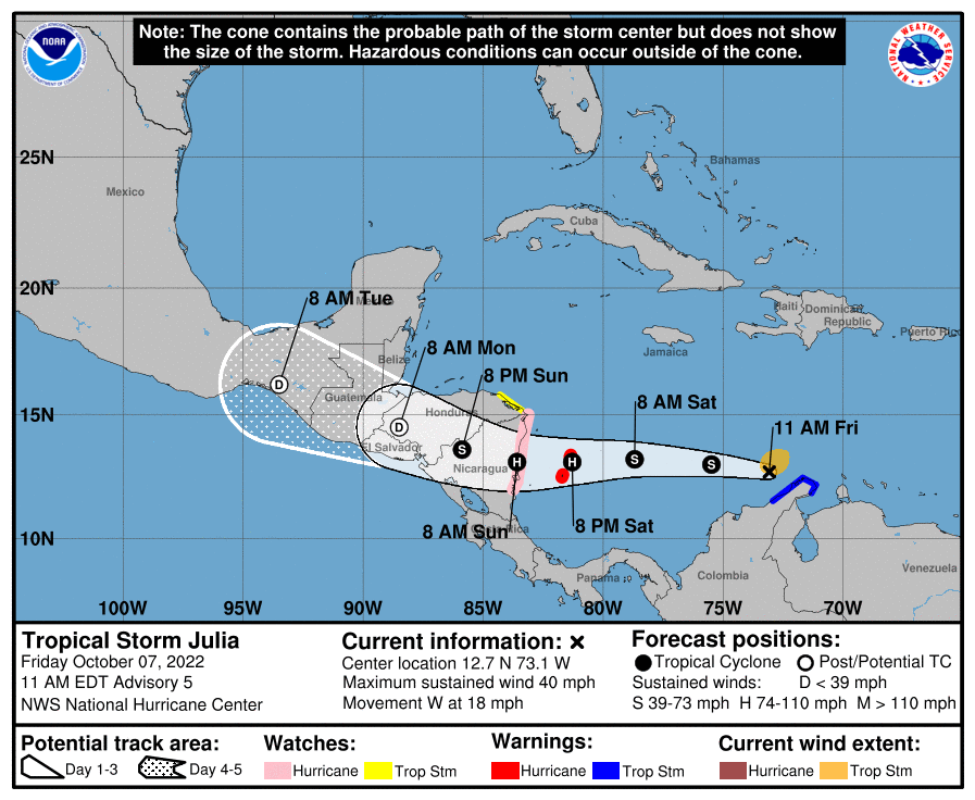
TD-12 did peter out before becoming a named storm and the tropical depression in the Caribbean, which brought flooding rains to Venezuela yesterday, was just upgraded to a tropical storm, Julia, which is forecast to strengthen to a Cat 1 hurricane before landfall on Sunday in Nicaragua. There will likely be catastrophic rainfall and flooding with mudslides in the mountains. Fortunately for the US, the storm should be steered west and dissipate over interior Central America or Mexico.
With no other storms on the horizon, it's almost a lock that this season will be, at most, normal with regard to activity (and maybe a bit below normal), which would make the seasonal forecasts wrong. Hard to imagine more than another 3-4 storms in the rest of October and November.
https://www.nhc.noaa.gov/graphics_at3.shtml?start#contents

Normal globally or just the US?
Neither. Thread, apart from the Ian detour, is about the Atlantic Basin (see first post).Normal globally or just the US?
Neither. Thread, apart from the Ian detour, is about the Atlantic Basin (see first post).
Do we have data globally?
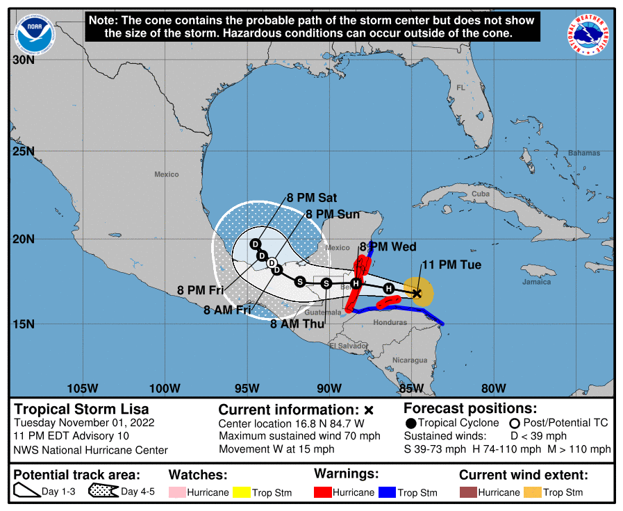
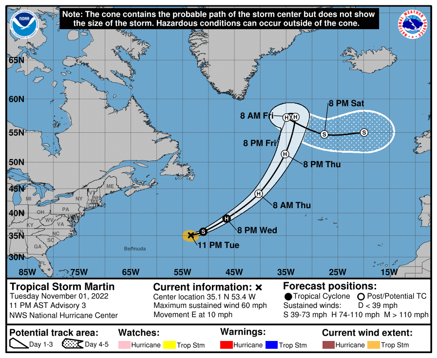
Well, we're seeing a late push of tropical activity in late October and early November, as Tropical Storm Lisa formed a few days ago in the Caribbean and is likely to make landfall in Belize tomorrow night as a Cat 1 hurricane (bringing life-threatening storm surge, winds, and flooding rains), while Tropical Storm Martin just formed today and is already up to a 60 mph storm in the central Atlantic and is forecast to also become a Cat 1 hurricane (as it transitions to an extratropical system in the North Atlantic over the next 24-36 hours), but is not expected to threaten any landmass.
These two storms, assuming they reach Cat 1 hurricane strength, as forecast, will bring the season to 13 named storms (14 is average), 7 hurricanes (7 is average) and 2 major hurricanes (3 is average), i.e., the season will be pretty close to average. However, the Colorado State seasonal forecast (where Dr. Grey first developed his fairly accurate tropical season forecasts) and the NOAA forecast were for above normal tropical activity this year, so unless we see an historic November (we rarely get more than 1-2 systems in Nov), those forecasts will be wrong (see the first post in the thread).
https://www.nhc.noaa.gov/


Yes. I am in the Daytona area now. Came down last week to help elderly family pack up the house after flooding. They are concerned about more water.
Something else for Florida this week?

Been out all day, so just catching up. Yes, this is a threat to FL/SE US as a tropical/subtropical system and our area as a hybrid system by next weekend. Starting a thread on this shortly...
Been out all day, so just catching up. Yes, this is a threat to FL/SE US as a tropical/subtropical system and our area as a hybrid system by next weekend. Starting a thread on this shortly...

Similar threads
- Replies
- 553
- Views
- 33K
- Replies
- 336
- Views
- 16K
- Replies
- 488
- Views
- 21K
- Replies
- 13
- Views
- 770
ADVERTISEMENT
ADVERTISEMENT