
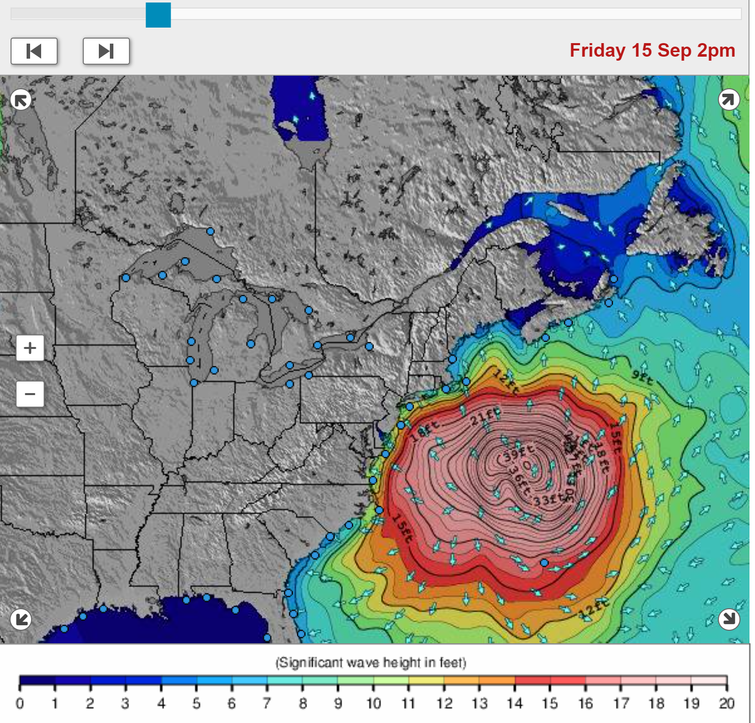
Tell my family I love them…🌊 😎You want wind and waves? Just wait, lol. Here are graphics of the projected windfield Friday morning, showing how huge Lee will get, as well as the projected wave heights. Gnarly.
https://www.surf-forecast.com/weather_maps/New-Jersey?hr=3&over=none&type=htsgw

Colleges
- American Athletic
- Atlantic Coast
- Big 12
- Big East
- Big Ten
- Colonial
- Conference USA
- Independents (FBS)
- Junior College
- Mountain West
- Northeast
- Pac-12
- Patriot League
- Pioneer League
- Southeastern
- Sun Belt
- Army
- Charlotte
- East Carolina
- Florida Atlantic
- Memphis
- Navy
- North Texas
- Rice
- South Florida
- Temple
- Tulane
- Tulsa
- UAB
- UTSA
- Boston College
- California
- Clemson
- Duke
- Florida State
- Georgia Tech
- Louisville
- Miami (FL)
- North Carolina
- North Carolina State
- Pittsburgh
- Southern Methodist
- Stanford
- Syracuse
- Virginia
- Virginia Tech
- Wake Forest
- Arizona
- Arizona State
- Baylor
- Brigham Young
- Cincinnati
- Colorado
- Houston
- Iowa State
- Kansas
- Kansas State
- Oklahoma State
- TCU
- Texas Tech
- UCF
- Utah
- West Virginia
- Illinois
- Indiana
- Iowa
- Maryland
- Michigan
- Michigan State
- Minnesota
- Nebraska
- Northwestern
- Ohio State
- Oregon
- Penn State
- Purdue
- Rutgers
- UCLA
- USC
- Washington
- Wisconsin
High Schools
- Illinois HS Sports
- Indiana HS Sports
- Iowa HS Sports
- Kansas HS Sports
- Michigan HS Sports
- Minnesota HS Sports
- Missouri HS Sports
- Nebraska HS Sports
- Oklahoma HS Sports
- Texas HS Hoops
- Texas HS Sports
- Wisconsin HS Sports
- Cincinnati HS Sports
- Delaware
- Maryland HS Sports
- New Jersey HS Hoops
- New Jersey HS Sports
- NYC HS Hoops
- Ohio HS Sports
- Pennsylvania HS Sports
- Virginia HS Sports
- West Virginia HS Sports
ADVERTISEMENT
You are using an out of date browser. It may not display this or other websites correctly.
You should upgrade or use an alternative browser.
You should upgrade or use an alternative browser.
OT: Hurricane Lee now a Cat 1 hurricane - likely landfall as near Cat 1 in Canada (or maybe far eastern Maine) on 9/16-17
- Thread starter RU848789
- Start date

Unlikely, since the storm will very likely pass about 175 miles east of Boston, meaning it will likely be a windy, rainy day, but there won't be lightning and the rain won't be torrential (maybe 1/2" in Boston Saturday morning/afternoon). To me the only question is the wind, which is forecast to be in the ~25 mph range with gusts to 35 mph during the game - I don't think those conditions are "dangerous" so I would think the game goes on. The one other thing is if the storm unexpectedly heads further west, which would bring more rains and higher winds to Boston, but that should be well known by tomorrow night.Any chance Florida State versus Boston College on Saturday at noon gets postponed or moved? I assume the weather in Boston at that time will be pretty terrible.
https://forecast.weather.gov/MapClick.php?lon=-71.07138&lat=42.37746
Fish? Tell that to the folks in Maine and Canada who will be impacted pretty seriously by a Cat 1 level storm.I dont make forecasts for fish
I get why you are imitating my post, and I'm flattered and all. So, you know, thanks for the compliment.Hey look here's a pic of a few CE libbers.

Front & center K-Bong in his freeboard CE days hanging with cultyQaude on left and diddles on right.
But why respond to me with an attack on other people? Also, why single out liberals? I didn't single out anybody's ideological affiliations in my posts. I singled out the gang of middle-school clique wanna-bes.
Which, btw, is what makes my post funny, and you missed w/your imitation.
No charge for this help w/your posting. Always happy to help a brother.
So when I show you my receipts of same pussyhat posts about CE libbers from years back you'll admit you're imitating me lol?I get why you are imitating my post, and I'm flattered and all. So, you know, thanks for the compliment.
But why respond to me with an attack on other people? Also, why single out liberals? I didn't single out anybody's ideological affiliations in my posts. I singled out the gang of middle-school clique wanna-bes.
Which, btw, is what makes my post funny, and you missed w/your imitation.
No charge for this help w/your posting. Always happy to help a brother.
Does it matter how I responded or posted? I did single-out a few posters in this thread that have made unflattering comments about those you obviously referred to in your meme--I mean that's pretty obvious. You used to be better at trash talk, think you need to get back into game shape and come on back to the CE Mildy!
I'm concerned for my daughter, son in law and grandkids who live near the Maine coastFish? Tell that to the folks in Maine and Canada who will be impacted pretty seriously by a Cat 1 level storm.
I'm not so flippant as this asswipe.
It's the same people attacking you that did on CE topics that are not allowed here.
Such children.
They all seem to share half a brain. I bet their periods have synced, too.

He didn't mention politics but you had to go there, cult of children that you are.Hey look here's a pic of a few CE libbers.
Front & center K-Bong in his freeboard CE days hanging with cultyQaude on left and diddles on right.
Dumb even for you. Geez even kbong understood the dig, dopey.
He didn't mention politics but you had to go there, cult of children that you are.
They all seem to share half a brain. I bet their periods have synced, too.

There you are in all your p-hat glory franny:They all seem to share half a brain. I bet their periods have synced, too.

There you are in all your p-hat glory franny:
Uh-oh ... Big Red be mad his name took on a whole new meaning.
Yikes...your obsession with, umm, that, is kinda creepy. I'll let you work that out on your own little dude.Uh-oh ... Big Red be mad his name took on a whole new meaning.
That's not true.Hey look here's a pic of a few CE libbers.
Front & center K-Bong in his freeboard CE days hanging with cultyQaude on left and diddles on right.
I look nothing like that.
Always mad, always whining about something.Uh-oh ... Big Red be mad his name took on a whole new meaning.
lol at the Pavlovian response of the CERWCJ. Too funny. Talk about triggered.
Well, dogs have bigger brains, more emotional stability and are capable of happiness.
However, both are known to shit on the carpet.
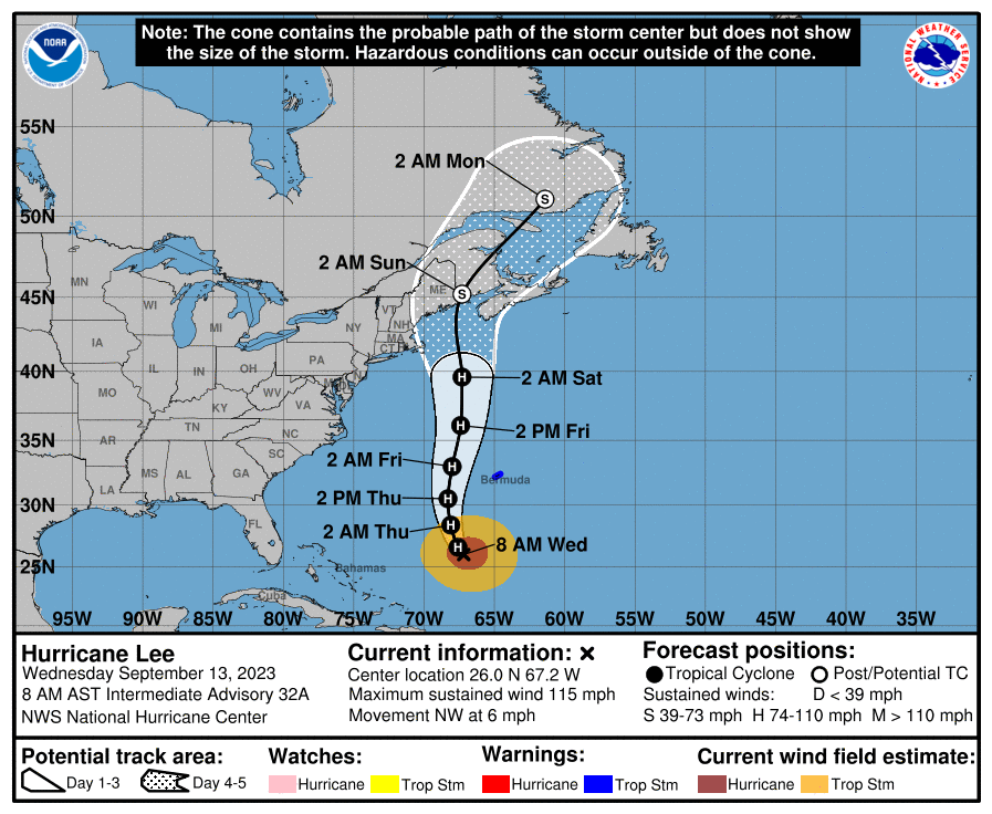
So last night's Euro joined the GFS with a bit of a westward shift in landfall, showing landfall in NE Maine; as a result, the NHC shifted the track westward about 50 miles, now showing landfall about 20 miles east of the Maine/Canada border (first time the NHC forecast track has shown a US landfall) in Roque Bluffs late Saturday night with close to Cat 1 winds (70-75 mph), as the storm is completing its transition to a much larger extratropical storm, which will likely have a 250+ mile radius of tropical storm force winds (it's at 200 miles now). Below is the NHC discussion on the shift in track.
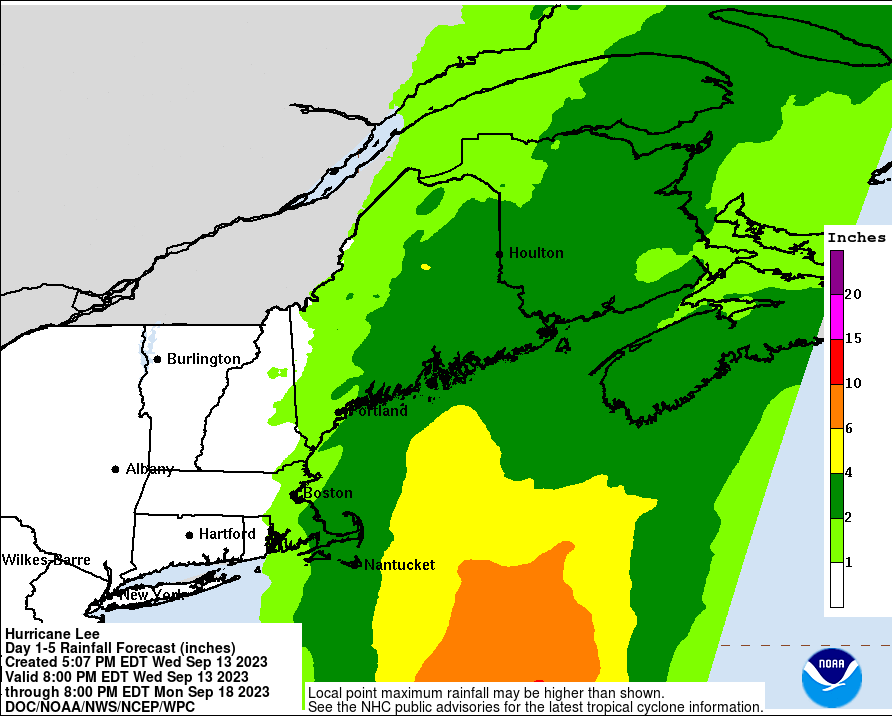
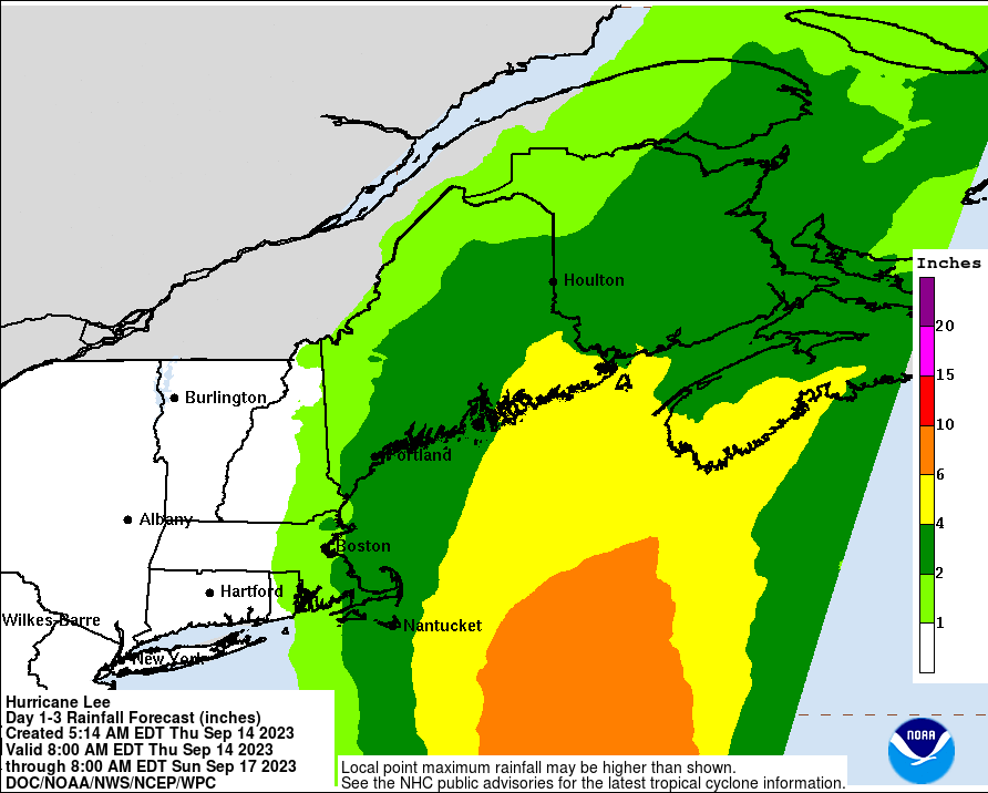
The track shift puts Cape Cod back onto the edge of the forecast cone, which doesn't mean they're likely to see landfall, but it does mean they're more likely to get significant winds, surge and rain (as the storm passes ~100 miles to their east), as will coastal NH and SW coastal Maine, while the rest of coastal Maine, especially from Bar Harbor NE-ward, and coastal New Brunswick/SW Nova Scotia, Canada (being on the stronger side of the storm) will likely get even more significant wind, surge and rain. Much of the area, including areas well inland in Maine/Canada, will get 2-4" of rain with higher amounts possible, so urban/stream flooding will be a major concern given recent rains.
Still zero impact on our weather, apart from it being a bit breezy on Saturday (10-20 mph winds) with some high clouds and heavy surf, erosion and riptides through Saturday.
https://www.nhc.noaa.gov/refresh/graphics_at3+shtml/114250.shtml?key_messages#contents
On days 3 and 4, Lee is expected to
maintain a general northward track offshore the northeastern U.S.
However, the global models are suggesting that the hurricane
will interact with a remnant mid-level trough over the mid-Atlantic
states, causing Lee to possibly bend just west of due north while
it moves across the Gulf of Maine. Under the assumption that the
global models will have a better handle on this mid-latitude
pattern as compared to the regional hurricane models, the NHC track
forecast is close to a consensus of the GFS and ECMWF models (GFEX)
on days 3, 4, and 5, and therefore ends up being a bit west and
then north of the previous prediction on those days.
FORECAST POSITIONS AND MAX WINDS
INIT 13/0900Z 25.7N 67.1W 100 KT 115 MPH
12H 13/1800Z 26.6N 67.6W 95 KT 110 MPH
24H 14/0600Z 28.4N 68.1W 90 KT 105 MPH
36H 14/1800Z 30.5N 68.3W 85 KT 100 MPH
48H 15/0600Z 33.0N 68.0W 80 KT 90 MPH
60H 15/1800Z 36.1N 67.4W 75 KT 85 MPH
72H 16/0600Z 39.6N 67.3W 70 KT 80 MPH
96H 17/0600Z 45.2N 67.3W 50 KT 60 MPH...POST-TROP/INLAND
120H 18/0600Z 51.0N 61.4W 35 KT 40 MPH...POST-TROP/INLAND
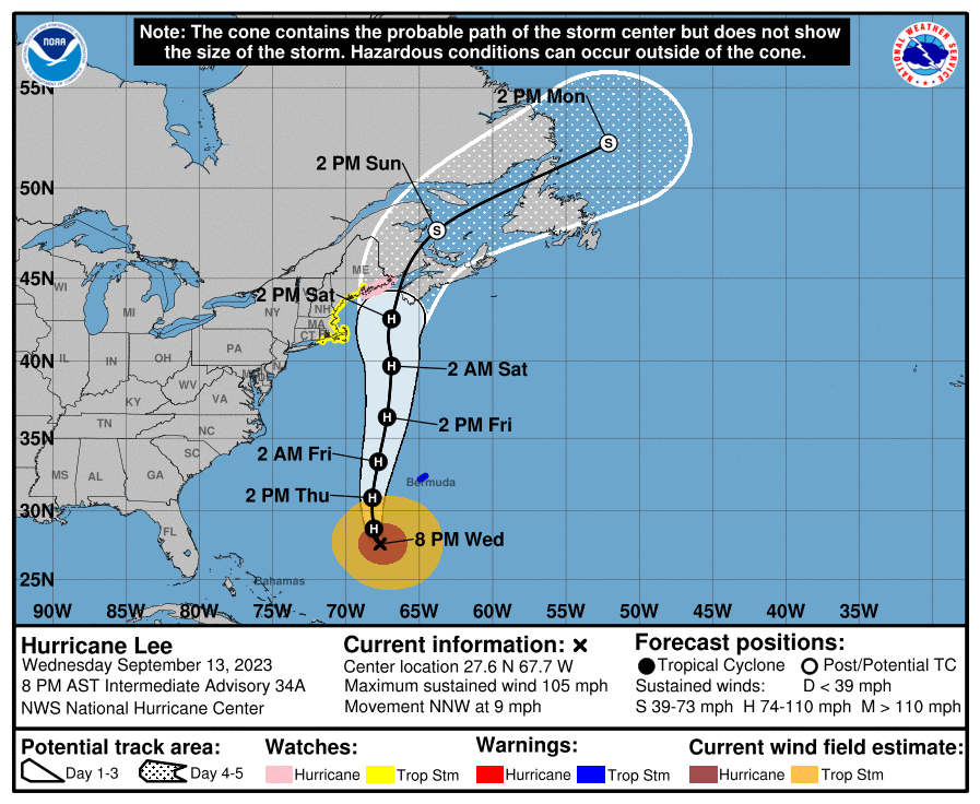
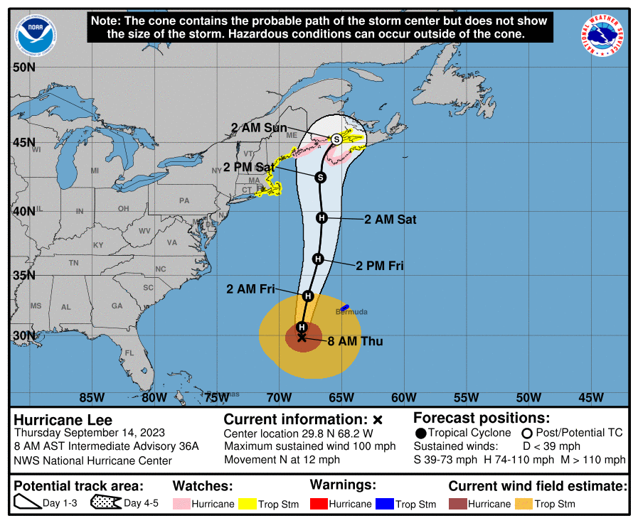
So, the NHC has moved the track center back east about 60 miles, so instead of landfall in far NE coastal Maine near Machias, the predicted landfall splits the uprights between the Maine/Canada border and the western tip of Nova Scotia, with the storm making landfall in Saint John in New Brunswick Canada (after brushing that tip of Nova Scotia); the track takes the storm about 25 miles SE of the Maine/Canada border, so Downeast Maine is still in the crosshairs here (and landfall could wobble back to being in Maine).
Lee will still be a Cat 1 hurricane around 2 pm Saturday when it's about 100 miles SSW of the mouth of the Bay of Fundy, between Eastport Maine and the western tip of Nova Scotia and the storm will be starting the transition to an extratropical storm, which is somewhat semantics at this point, as the storm will still be packing 70-75 mph winds when it makes landfall. Hurricane watches are up from Stonington, Maine to the Maine/Canadiand border and presumably for NB/NS Canada and Tropical Storm Watches are up from Watch Hill, RI to Stonington, ME. These will likely become warnings by tomorrow night.
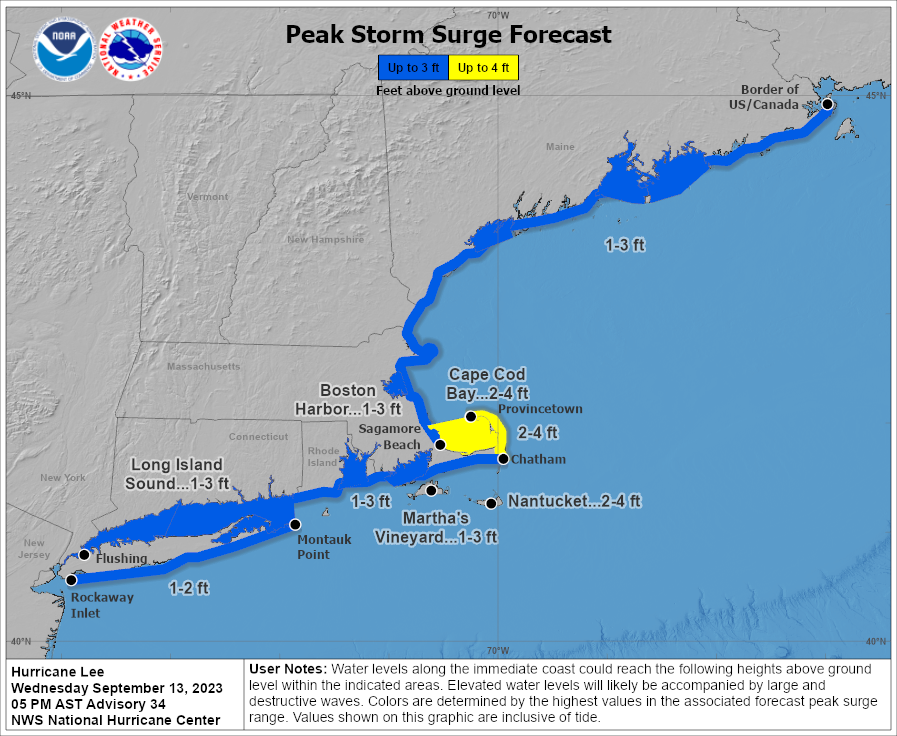
This is not going to be a generally catastrophic storm, but 70-75 mph winds can do some damage, especially to trees, leading to some power outages (as can even 50-60 mph winds where the TS watches are up and inland in Maine/Canada) and with the large size of the storm bringing a long fetch of winds, storm surges along the entire New England Coast down to LI will be 1-3 feet with 2-4 feet along Cape Cod and Cape Cod Bay, where there is a storm surge watch up. Coastal flooding will likely be minor to moderate. And 1-2" of rain in RI/SE MA, SE NH and SW ME could lead to some flooding while flooding risks are more significant for the rest of Maine, including inland where 2-4" of rain is expected (same for most of New Brunswick/Nova Scotia).
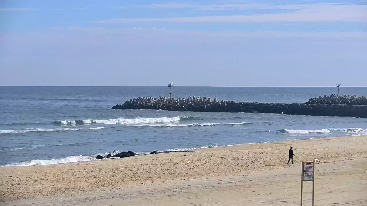
For NJ/NYC, coastal flooding is not expected, but heavy surf, beach erosion and riptides will continue from now through Saturday. Saturday will be a beautiful day with highs in the mid-70s, partly cloudy skies and comfortable humidity; however it will be breezy with 10-20 mph winds.
FORECAST POSITIONS AND MAX WINDS
INIT 13/2100Z 27.4N 67.6W 90 KT 105 MPH
12H 14/0600Z 28.7N 68.1W 90 KT 105 MPH
24H 14/1800Z 30.9N 68.2W 85 KT 100 MPH
36H 15/0600Z 33.4N 67.8W 80 KT 90 MPH
48H 15/1800Z 36.4N 67.2W 75 KT 85 MPH
60H 16/0600Z 39.7N 66.9W 70 KT 80 MPH
72H 16/1800Z 42.6N 66.9W 65 KT 75 MPH
96H 17/1800Z 47.7N 63.8W 45 KT 50 MPH...POST-TROP/EXTRATROP
120H 18/1800Z 52.3N 52.1W 35 KT 40 MPH...POST-TROP/EXTRATROP
https://www.nhc.noaa.gov/refresh/graphics_at3+shtml/114250.shtml?cone#contents
Last edited:
Town of Orleans Beach Cams Page | StreamPros
 streampros.net
Two webcams, if they stay online, in Orleans on the Cape. One bayside, one on the Ocean.
Might be interesting to watch this weekend.
Look at the slow-thinking old coot projecting again, sad.Always mad, always whining about something.
Would you two just shut up and take your baby a$$ shite elsewhere? You are like two little children.Look at the slow-thinking old coot projecting again, sad.
Waves were very loud yesterday. Don't hear them right now.How’s the surf down the shore? Thinking about heading down from North Jersey.
Manasquan Beach Cam & Surf Report - The Surfers View
View the Manasquan, New Jersey Beach Cam and Surf Report for real-time wave conditions, tides, water temp, storm coverage and local weather.
 thesurfersview.com
How about replying in-kind to Kfan? Or try the ignore feature bud.Would you two just shut up and take your baby a$$ shite elsewhere? You are like two little children.
How about adding something to the conversation about the hurricane? Why not engage on a topic most find interesting instead of only ever coming into these threads and fighting with people? You're a bright guy and surely capable of adding something of value.How about replying in-kind to Kfan? Or try the ignore feature bud.
I imagine a webcam in Eastport Maine might be interesting too...Town of Orleans Beach Cams Page | StreamPros
Two webcams, if they stay online, in Orleans on the Cape. One bayside, one on the Ocean.
Might be interesting to watch this weekend.
Yawn...I really don't need to explain anything to you, but I'll repeat: I find most weather threads interesting, and I'll post on those (or any) threads as the conversation shifts around, as I did here on page 3 which was particularly of value. Again, why don't you stop getting upset when some thread doesn't go your way? Your info gathering in weather threads is a net positive. But when you inject your politics, or act like a 2-yr old because bac started a game weather thread before you did for example, you invite a lot of mocking.How about adding something to the conversation about the hurricane? Why not engage on a topic most find interesting instead of only ever coming into these threads and fighting with people? You're a bright guy and surely capable of adding something of value.
So, the NHC has moved the track center back east about 60 miles, so instead of landfall in far NE coastal Maine near Machias, the predicted landfall splits the uprights between the Maine/Canada border and the western tip of Nova Scotia, with the storm making landfall in Saint John in New Brunswick Canada (after brushing that tip of Nova Scotia); the track takes the storm about 25 miles SE of the Maine/Canada border, so Downeast Maine is still in the crosshairs here (and landfall could wobble back to being in Maine).
Lee will still be a Cat 1 hurricane around 2 pm Saturday when it's about 100 miles SSW of the mouth of the Bay of Fundy, between Eastport Maine and the western tip of Nova Scotia and the storm will be starting the transition to an extratropical storm, which is somewhat semantics at this point, as the storm will still be packing 70-75 mph winds when it makes landfall. Hurricane watches are up from Stonington, Maine to the Maine/Canadiand border and presumably for NB/NS Canada and Tropical Storm Watches are up from Watch Hill, RI to Stonington, ME. These will likely become warnings by tomorrow night.
This is not going to be a generally catastrophic storm, but 70-75 mph winds can do some damage (as can even 50-60 mph winds where the TS watches are up and inland in Maine/Canada) and with the large size of the storm bringing a long fetch of winds, storm surges along the entire New England Coast down to LI will be 1-3 feet with 2-4 feet along Cape Cod and Cape Cod Bay, where there is a storm surge watch up. Coastal flooding will likely be minor to moderate. And 1-2" of rain in RI/SE MA, SE NH and SW ME could lead to some flooding while flooding risks are more significant for the rest of Maine, including inland where 2-4" of rain is expected (same for most of New Brunswick/Nova Scotia).
For NJ/NYC, coastal flooding is not expected, but heavy surf, beach erosion and riptides will continue from now through Saturday. Saturday will be a beautiful day with highs in the mid-70s, partly cloudy skies and comfortable humidity; however it will be breezy with 10-20 mph winds.
FORECAST POSITIONS AND MAX WINDS
INIT 13/2100Z 27.4N 67.6W 90 KT 105 MPH
12H 14/0600Z 28.7N 68.1W 90 KT 105 MPH
24H 14/1800Z 30.9N 68.2W 85 KT 100 MPH
36H 15/0600Z 33.4N 67.8W 80 KT 90 MPH
48H 15/1800Z 36.4N 67.2W 75 KT 85 MPH
60H 16/0600Z 39.7N 66.9W 70 KT 80 MPH
72H 16/1800Z 42.6N 66.9W 65 KT 75 MPH
96H 17/1800Z 47.7N 63.8W 45 KT 50 MPH...POST-TROP/EXTRATROP
120H 18/1800Z 52.3N 52.1W 35 KT 40 MPH...POST-TROP/EXTRATROP
https://www.nhc.noaa.gov/refresh/graphics_at3+shtml/114250.shtml?cone#contents
No significant changes overnight as the 0Z models are almost all showing landfall between Downeast Maine and SW Nova Scotia, with the center of the forecast track still grazing the western tip of NS as a ~70 mph storm transitioning to extratropical and slamming into New Brunswick, Canada near Saint John. The surge forecast from last night is the same, but the rainfall forecast was increased, as per below and the updated track guidance is also below. Impacts are about the same as detailed last night, too. This is going to be a very impactful storm for much of central/eastern Maine and most of New Brunswick/Nova Scotia, including well inland. Minor to moderate impacts are likely for the rest of SE New England, except for the higher storm surge for Cape Cod.
FORECAST POSITIONS AND MAX WINDS
INIT 14/0900Z 29.1N 68.1W 85 KT 100 MPH
12H 14/1800Z 30.7N 68.2W 80 KT 90 MPH
24H 15/0600Z 33.3N 67.7W 80 KT 90 MPH
36H 15/1800Z 36.3N 66.9W 75 KT 85 MPH
48H 16/0600Z 39.5N 66.6W 70 KT 80 MPH
60H 16/1800Z 42.5N 66.7W 60 KT 70 MPH
72H 17/0600Z 45.2N 65.4W 50 KT 60 MPH...POST-TROP/EXTRATROP
96H 18/0600Z 50.2N 58.1W 40 KT 45 MPH...POST-TROP/EXTRATROP
120H 19/0600Z 54.6N 45.8W 40 KT 45 MPH...POST-TROP/EXTRATROP
Last edited:
Supposed to head up to Maine (Portland, Brunswick & Cape Needick) area's for work the week of 9/26 - wondering if the storm will hinder those plans for those area's
Your posts on page 3 had nothing to do with the hurricane and only served to sideline the thread for awhile. If you want to post about climate change in another thread, have at it and we can argue about it there, but why do that in this thread? You can obviously post whatever you want, but why not engage on the thread topic? I'm actually curious, since there wasn't any politics or arguing with bac about anything in this thread.Yawn...I really don't need to explain anything to you, but I'll repeat: I find most weather threads interesting, and I'll post on those (or any) threads as the conversation shifts around, as I did here on page 3 which was particularly of value. Again, why don't you stop getting upset when some thread doesn't go your way? Your info gathering in weather threads is a net positive. But when you inject your politics, or act like a 2-yr old because bac started a game weather thread before you did for example, you invite a lot of mocking.
Yep, although the weakening is due to shear, not ocean water temps, at least not yet, as the SSTs are still quite warm under Lee now...Worth noting that current satellite imagery shows Lee to be somewhat ragged-looking, this morning, with exposure of the southwestern quadrant and no defined eye. Still a big and dangerous storm, but clearly weakening as it moves over colder water.
The latest shear analyses suggest that moderate southwesterly shear
has begun to affect Lee, and this is confirmed by the offset of
the aircraft fixes relative to the satellite eye feature. The
shear is forecast to increase further in 24-36 hours, which will
cause Lee to ingest drier and more stable air into its circulation.
In addition, sea surface temperatures along Lee's future path drop
off significantly after 36 hours.
Again, my post on page 3 was responding to another poster questioning the data raised ITT. If you don't get it, I can't help you lol...what Board thread doesn't take a couple (or many) twists and turns? Yeh you slipped in your climate politics in a couple posts, and as usual you cry "politics" whenever there's any pushback. And sorry, your act with bac and that NW game weather thread is gonna be hard to live down here, c'mon, of all people you have to realize that lol.Your posts on page 3 had nothing to do with the hurricane and only served to sideline the thread for awhile. If you want to post about climate change in another thread, have at it and we can argue about it there, but why do that in this thread? You can obviously post whatever you want, but why not engage on the thread topic? I'm actually curious, since there wasn't any politics or arguing with bac about anything in this thread.
I said in another thread yesterday I probably shouldn’t have gone in.How’s the surf down the shore? Thinking about heading down from North Jersey.
And I shouldn’t today either, but I will. 🙂
I said in another thread yesterday I probably shouldn’t have gone in.
And I shouldn’t today either, but I will. 🙂
There’s a reason us men have a lower life expectancy than women…
I'll be sitting on the beach because.......I said in another thread yesterday I probably shouldn’t have gone in.
And I shouldn’t today either, but I will. 🙂
Hookers and blow?There’s a reason us men have a lower life expectancy than women…
I've seen UNH vs Maine several times in Orono, Maine. Nice stadium.If only the Maine Black Bears had a message board: they have a 3:30 home game this Saturday.
That’s a fail. Maine announced yesterday evening the game was moved to Friday at 6:30 to get ahead of the storm.If only the Maine Black Bears had a message board: they have a 3:30 home game this Saturday.
And there are people (actually just one) who say he isn’t funny.🤷♂️
Similar threads
- Replies
- 561
- Views
- 25K
- Replies
- 47
- Views
- 3K
- Replies
- 152
- Views
- 7K
ADVERTISEMENT
Latest posts
-
-
-
-
If you think Rutgers season hurt Ace and Dylan's draft stock...
- Latest: scarlet_knight
ADVERTISEMENT