A great American brewery.You can get Yuengling beer anywhere in the state.
That should be right up your alley.
Is it too strong for you?
A great American brewery.You can get Yuengling beer anywhere in the state.
That should be right up your alley.
I hear drinking to much of it causes wet brain.

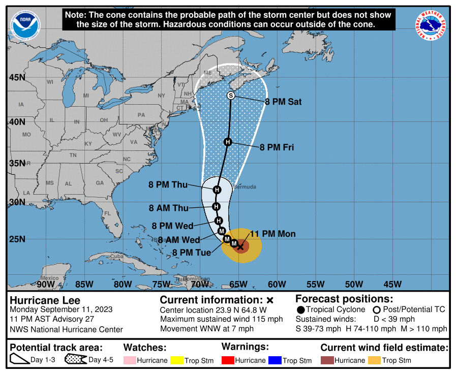
Last night's 0Z Euro shifted west by about 125 miles, such that it has Lee now coming within 50-75 miles of Cape Cod and making landfall on the central Maine coast; however, the NHC is essentially ignoring that vs. the vast model consensus for landfall anywhere from eastern Maine to SW Nova Scotia and they still have the center of the track making landfall on the far SW tip of Nova Scotia as a 70-75 mph (just about Cat 1) storm transitioning from tropical to extratropical.Well, we finally have a forecasted landfall at the SW tip of Nova Scotia Saturday evening and Lee is expected to be a mostly extratropical storm by that point with ~70 mph winds, as Lee is expected to weaken a fair amount between now (with 115 mph winds) and landfall, as the storm will pass over a stretch of colder than normal water, churned up in Franklin's wake.
The chances of a Cape Cod/NH/SW Maine landfall are now very low, with landfall now focused on Downeast Maine to central Nova Scotia, centered on SW Nova Scotia (with New Brunswick, Canada also possible). This also means the chances of anything more than breezy conditions for NJ during tailgates and the game are now nil. Heavy surf, riptides and beach erosion, however, will be issues for the entire coast from NC to Canada for the next several days.
Also, when storms go extratropical which they usually do that far north, they usually expand considerably with regard to windfield and precip shield, so anywhere within about 150-200 miles of Lee's track will at least likely get heavy rains (3-6" from Cape Cod up through most of Maine and all of Atlantic Canada) and probable tropical storm force winds (39 mph or more). The folks up there are going to get hammered, but at least we didn't get a Cat 5 hurricane hitting the Caribbean islands or Florida or the SE coast (or a Cat 3/4 hitting our area).
FORECAST POSITIONS AND MAX WINDS
INIT 12/0300Z 23.9N 64.8W 100 KT 115 MPH
12H 12/1200Z 24.4N 65.6W 105 KT 120 MPH
24H 13/0000Z 25.0N 66.5W 105 KT 120 MPH
36H 13/1200Z 26.1N 67.2W 100 KT 115 MPH
48H 14/0000Z 27.5N 67.6W 95 KT 110 MPH
60H 14/1200Z 29.4N 67.9W 90 KT 105 MPH
72H 15/0000Z 31.6N 67.8W 80 KT 90 MPH
96H 16/0000Z 37.6N 66.4W 70 KT 80 MPH
120H 17/0000Z 43.0N 66.0W 60 KT 70 MPH...POST-TROP/EXTRATROP
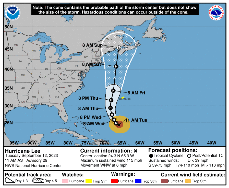
It's looking like that 0Z Euro run from last night was a blip, as today's 12Z run moved landfall back east about 100 miles, in far eastern Maine. The GFS has landfall on the far SW tip of Nova Scotia, as does the UK, while the CMC has it in central Nova Scotia, so the NHC decision to leave landfall right around the SW tip of Nova Scotia looks good right now.Last night's 0Z Euro shifted west by about 125 miles, such that it has Lee now coming within 50-75 miles of Cape Cod and making landfall on the central Maine coast; however, the NHC is essentially ignoring that vs. the vast model consensus for landfall anywhere from eastern Maine to SW Nova Scotia and they still have the center of the track making landfall on the far SW tip of Nova Scotia as a 70-75 mph (just about Cat 1) storm transitioning from tropical to extratropical.
The Euro did pull a major coup over all of the other models for Sandy, correctly predicting a NJ landfall 7-8 days out vs. the other models not starting to see that until about 5 days out - however, the gap between the Euro and the GFS/UK/CMC and the hurricane models has tightened up and we've seen some more Euro misses lately, so it's understandable that one run of the Euro hasn't moved the needle much. Let's see what happens this afternoon with the 12Z runs (also the 6Z Euro ensembles shifted back east a bit vs. the 0Z ensembles, perhaps presaging a shift of the operational model - the op Euro only runs out to 90 hrs at 6Z, so we'll have to wait for 12Z).
FORECAST POSITIONS AND MAX WINDS
INIT 12/1500Z 24.3N 65.9W 100 KT 115 MPH
12H 13/0000Z 24.8N 66.6W 100 KT 115 MPH
24H 13/1200Z 25.9N 67.3W 100 KT 115 MPH
36H 14/0000Z 27.4N 67.8W 95 KT 110 MPH
48H 14/1200Z 29.4N 68.2W 90 KT 105 MPH
60H 15/0000Z 31.6N 68.0W 85 KT 100 MPH
72H 15/1200Z 34.3N 67.4W 80 KT 90 MPH
96H 16/1200Z 40.7N 66.6W 65 KT 75 MPH
120H 17/1200Z 45.3N 65.9W 45 KT 50 MPH...POST-TROP/EXTRATROP
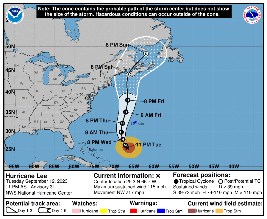
It's looking like that 0Z Euro run from last night was a blip, as today's 12Z run moved landfall back east about 100 miles, in far eastern Maine. The GFS has landfall on the far SW tip of Nova Scotia, as does the UK, while the CMC has it in central Nova Scotia, so the NHC decision to leave landfall right around the SW tip of Nova Scotia looks good right now.
Cape Cod, NH and far SW Maine now look to be almost out of the woods for landfall, but those areas should still expect TS force winds and heavy rain (1-3"), while areas towards eastern Maine and much of Atlantic Canada will likely see 3-5" of rain and possible hurricane force wind gusts. Given the relatively slow moving storm (most tropical cyclones move significantly faster as they move north of our latitude and transition to extratropical storms), it's possible the rainfall forecasts are underdone and flooding, including well inland of the coast, could be a major issue. Surge, especially east of the storm's center will also provide at least moderate impact as will hurricane force gusts.
Fortunately, for our area, just a little breezy on Saturday with some high clouds - perfect day for tailgating and football. No model right now has any rain west of Suffolk County, LI. As per previous posts, though, we'll see heavy surf, beach erosion and riptides in our area.
I always wait for R Official WeatherKingBac to get the official status on TKR weather information.Sounds like this thread can finally go to it's rightful place of rest.
Enjoy the game guys!
+1Sounds like this thread can finally go to it's rightful place of rest.
Enjoy the game guys!
Congrats on another ridiculous troll post. bac hasn't even posted in this thread, so your wait may be pretty damn long, lol. Maybe try reading a little before you post.I always wait for R Official WeatherKingBac to get the official status on TKR weather information.
He hasn't posted since he knows it's a meaningless fish storm.Congrats on another ridiculous troll post. bac hasn't even posted in this thread, so your wait may be pretty damn long, lol. Maybe try reading a little before you post.
Get a life. Don’t read these threads if it bothers you so much. It’s pathetic.He hasn't posted since he knows it's a meaningless fish storm.
It's looking like that 0Z Euro run from last night was a blip, as today's 12Z run moved landfall back east about 100 miles, in far eastern Maine. The GFS has landfall on the far SW tip of Nova Scotia, as does the UK, while the CMC has it in central Nova Scotia, so the NHC decision to leave landfall right around the SW tip of Nova Scotia looks good right now.
Cape Cod, NH and far SW Maine now look to be almost out of the woods for landfall, but those areas should still expect TS force winds and heavy rain (1-3"), while areas towards eastern Maine and much of Atlantic Canada will likely see 3-5" of rain and possible hurricane force wind gusts. Given the relatively slow moving storm (most tropical cyclones move significantly faster as they move north of our latitude and transition to extratropical storms), it's possible the rainfall forecasts are underdone and flooding, including well inland of the coast, could be a major issue. Surge, especially east of the storm's center will also provide at least moderate impact as will hurricane force gusts.
Fortunately, for our area, just a little breezy on Saturday with some high clouds - perfect day for tailgating and football. No model right now has any rain west of Suffolk County, LI. As per previous posts, though, we'll see heavy surf, beach erosion and riptides in our area.
So, just like Sandy in 2012, you're expressing a cavalier lack of concern or empathy for the significant wind/surge/flooding damage that will hit Maine (and maybe Cape Cod/coastal NH) and Nova Scotia/New Brunswick from the coasts to the interior, as well as the risks to life and limb for some living in those areas. At least you're a consistent d-bag about such things.He hasn't posted since he knows it's a meaningless fish storm.
Sadly, it's orchestrated CE board crap. Next likely step is to try to bait people into some contentious discussion about the usual political topics that would get the thread locked/moved/deleted. Troll 101 stuff that was already tried on page 3 by the usual suspects.Get a life. Don’t read these threads if it bothers you so much. It’s pathetic.
Eastern Maine has had rain off and on all week, so the 4-8 inches they are forecasting will be falling on already saturated ground and definitely cause issues. The surge and high wave heights with the storm will be damaging as well.So, just like Sandy in 2012, you're expressing a cavalier lack of concern or empathy for the significant wind/surge/flooding damage that will hit Maine (and maybe Cape Cod/coastal NH) and Nova Scotia/New Brunswick from the coasts to the interior, as well as the risks to life and limb for some living in those areas. At least you're a consistent d-bag about such things.
Trigger alert!

Sadly, it's orchestrated CE board crap. Next likely step is to try to bait people into some contentious discussion about the usual political topics that would get the thread locked/moved/deleted. Troll 101 stuff that was already tried on page 3 by the usual suspects.

I read just fine knucklehead--bac posted about the VTech game weather outlook in that thread, the game to which cali referenced. Stop being so prickly and roll with the Board flow, or just put posters that hurt your feelings on ignore lol.Congrats on another ridiculous troll post. bac hasn't even posted in this thread, so your wait may be pretty damn long, lol. Maybe try reading a little before you post.
I would hold back on plenty of sunshine, could still happen but. Lee's swirl could bring some clouds in through the day but we should avoid any precipitation
Wrong again lol. One poster asked about stats referenced earlier ITT and there was a relevant reply. Then you had a hissy fit, that was summarily rebuked. You realize you don't own TKR, right?Sadly, it's orchestrated CE board crap. Next likely step is to try to bait people into some contentious discussion about the usual political topics that would get the thread locked/moved/deleted. Troll 101 stuff that was already tried on page 3 by the usual suspects.
Remember the big board split between TKR and the past owners? He declared his undying love and support for the old crew that moved and said he would only post there. Problem is, not many folks joined them. A few weeks later he came crawling back. It's all about attention. He's the rutgersal of weather threads. LOL!Wrong again lol. One poster asked about stats referenced earlier ITT and there was a relevant reply. Then you had a hissy fit, that was summarily rebuked. You realize you don't own TKR, right?
Lol so true. Just a couple weeks ago Nimbers was whining about bac starting the NW game weather thread before he did. Too funny.Remember the big board split between TKR and the past owners? He declared his undying love and support for the old crew that moved and said he would only post there. Problem is, not many folks joined them. A few weeks later he came crawling back. It's all about attention. He's the rutgersal of weather threads. LOL!
It's the same people attacking you that did on CE topics that are not allowed here.Sadly, it's orchestrated CE board crap. Next likely step is to try to bait people into some contentious discussion about the usual political topics that would get the thread locked/moved/deleted. Troll 101 stuff that was already tried on page 3 by the usual suspects.
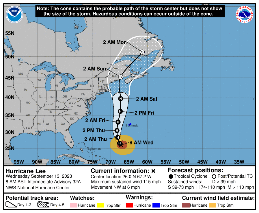
Lee is still a Cat 3 hurricane with 115 mph winds and in some ways is becoming more powerful, overall, as the windfield has expanded significantly (so the total energy of the storm is greater), with hurricane force winds extending outward up to 125 miles from the center and tropical-storm-force winds extending outward up to 240 miles. This means Bermuda will likely get some hurricane force winds, some surge and heavy rain as Lee passes about 100 miles west of the island on Thursday.
Beyond that, there has been very little forecast track change, with the NHC cone showing landfall between the central Maine coast and the NW Nova Scotia coast as a 70-75 mph (Cat 1 winds) extratropical storm, with the center of the cone being just over the far SW tip of Nova Scotia only ~30 miles (in track shift) from the Maine/New Brunswick Canada border. There could be significant wind/surge damage near and east of landfall and heavy rains within 150 miles of landfall including well inland in Maine and Canada.
Cape Cod/NH/SE Maine are now out of the cone, so landfall in those locations is now very unlikely, although impacts will be significant with regard to rainfall, surf, some surge and tropical storm force winds there. Also, tonight's 0Z models show a NE Maine coast landfall (GFS) and a SW Nova Scotia landfall (UK and CMC), i.e., nothing that is likely to change the NHC's track (Euro to come).
Still near zero impact on our weather, other than a bit breezy during Saturday and some high clouds, but will still be a gorgeous day for tailgates/football - heavy surf/erosion/riptides will be an issue though from now through Saturday.
FORECAST POSITIONS AND MAX WINDS
INIT 13/0300Z 25.3N 66.7W 100 KT 115 MPH
12H 13/1200Z 26.1N 67.2W 100 KT 115 MPH
24H 14/0000Z 27.7N 67.8W 95 KT 110 MPH
36H 14/1200Z 29.7N 68.2W 90 KT 105 MPH
48H 15/0000Z 32.1N 67.9W 80 KT 90 MPH
60H 15/1200Z 35.0N 67.1W 75 KT 85 MPH
72H 16/0000Z 38.0N 66.6W 75 KT 85 MPH
96H 17/0000Z 44.0N 66.4W 60 KT 70 MPH...POST-TROP/EXTRATROP
120H 18/0000Z 48.5N 62.0W 40 KT 45 MPH...POST-TROP/EXTRATROP
lol at the Pavlovian response of the CERWCJ. Too funny. Talk about triggered.

You really do struggle with comprehension and context - I'm laughing at you guys for your silly pack behavior and somehow you think my feelings are hurt, lol. I could provide some tutoring if you like.
Lol it's very obvious you're triggered and lashing out, but nice try bro.You really do struggle with comprehension and context - I'm laughing at you guys for your silly pack behavior and somehow you think my feelings are hurt, lol. I could provide some tutoring if you like.
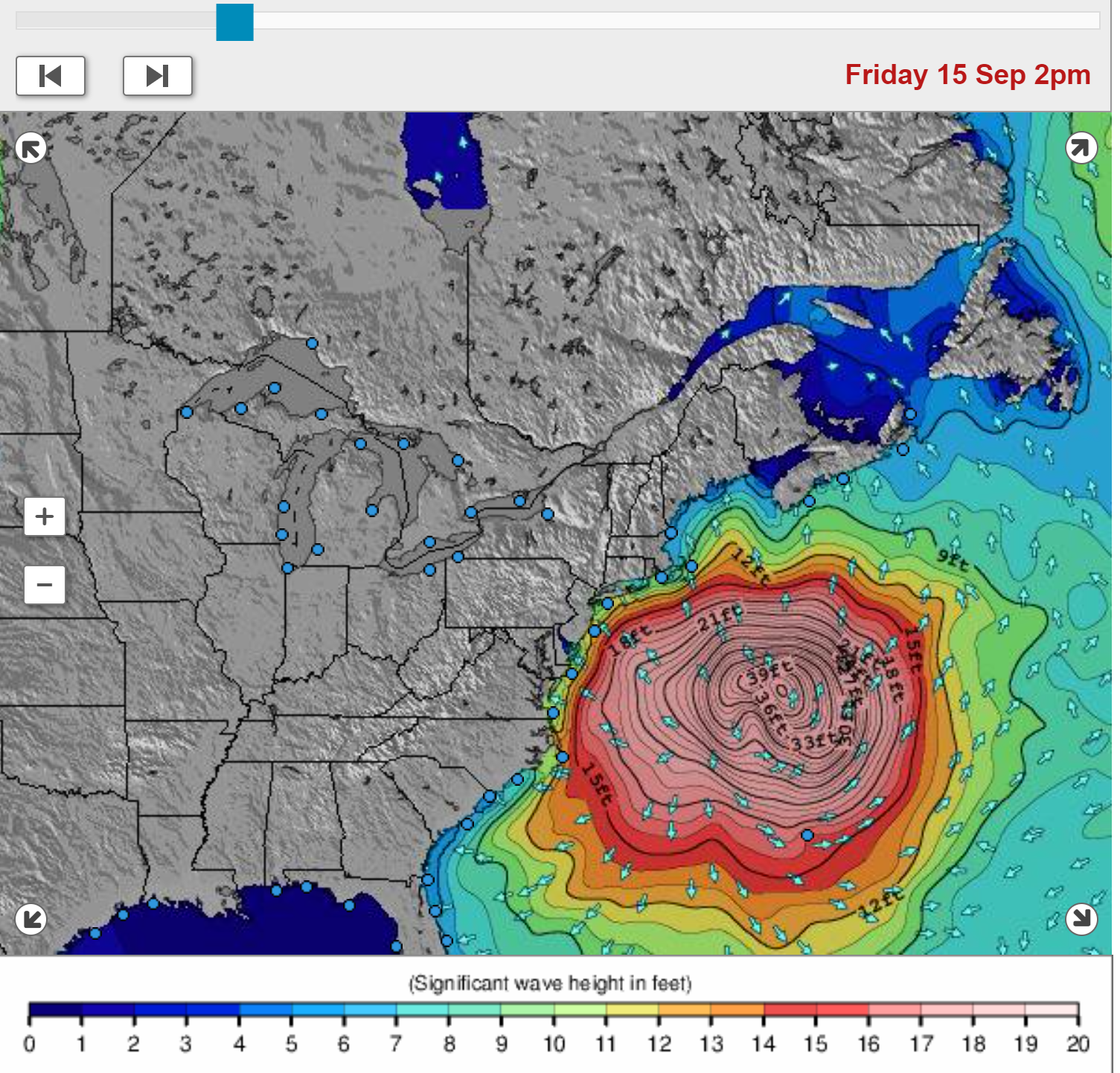
You want wind and waves? Just wait, lol. Here are graphics of the projected windfield Friday morning, showing how huge Lee will get, as well as the projected wave heights. Gnarly.Was in the ocean (alone) yesterday and there was a set of waves where King Neptune basically told me…”what, are you stupid or something? Go swim in the North End pool you idiot.🙄”
If the weather cooperates, I’ll be back in today after work. So yes, I am stupid.🙂

Lol it's very obvious you're triggered and lashing out, but nice try bro.
Good point.Is it a nice try though? The man is so desperate for attention you can smell it.

^^^^ nailed it.The CE board middle-school clique girls.
Cali's the one with the pink shoes. Not that there's anything wrong with that. T's both the far and near ones because he needs to be folded over to prevent scraping his head on light poles.
I always wait for R Official WeatherKingBac to get the official status on TKR weather information.
Hey look here's a pic of a few CE libbers.The CE board middle-school clique girls.
Cali's the one with the pink shoes. Not that there's anything wrong with that. T's both the far and near ones because he needs to be folded over to prevent scraping his head on light poles.