
Colleges
- American Athletic
- Atlantic Coast
- Big 12
- Big East
- Big Ten
- Colonial
- Conference USA
- Independents (FBS)
- Junior College
- Mountain West
- Northeast
- Pac-12
- Patriot League
- Pioneer League
- Southeastern
- Sun Belt
- Army
- Charlotte
- East Carolina
- Florida Atlantic
- Memphis
- Navy
- North Texas
- Rice
- South Florida
- Temple
- Tulane
- Tulsa
- UAB
- UTSA
- Boston College
- California
- Clemson
- Duke
- Florida State
- Georgia Tech
- Louisville
- Miami (FL)
- North Carolina
- North Carolina State
- Pittsburgh
- Southern Methodist
- Stanford
- Syracuse
- Virginia
- Virginia Tech
- Wake Forest
- Arizona
- Arizona State
- Baylor
- Brigham Young
- Cincinnati
- Colorado
- Houston
- Iowa State
- Kansas
- Kansas State
- Oklahoma State
- TCU
- Texas Tech
- UCF
- Utah
- West Virginia
- Illinois
- Indiana
- Iowa
- Maryland
- Michigan
- Michigan State
- Minnesota
- Nebraska
- Northwestern
- Ohio State
- Oregon
- Penn State
- Purdue
- Rutgers
- UCLA
- USC
- Washington
- Wisconsin
High Schools
- Illinois HS Sports
- Indiana HS Sports
- Iowa HS Sports
- Kansas HS Sports
- Michigan HS Sports
- Minnesota HS Sports
- Missouri HS Sports
- Nebraska HS Sports
- Oklahoma HS Sports
- Texas HS Hoops
- Texas HS Sports
- Wisconsin HS Sports
- Cincinnati HS Sports
- Delaware
- Maryland HS Sports
- New Jersey HS Hoops
- New Jersey HS Sports
- NYC HS Hoops
- Ohio HS Sports
- Pennsylvania HS Sports
- Virginia HS Sports
- West Virginia HS Sports
ADVERTISEMENT
You are using an out of date browser. It may not display this or other websites correctly.
You should upgrade or use an alternative browser.
You should upgrade or use an alternative browser.
OT: Major Winter Storm for Philly-NJ-NYC Area (12-24" very likely) for late Sun (1/31) into Tues (2/2)
- Thread starter RU848789
- Start date
- Status
- Not open for further replies.

Thank you. I'll bump it up a touch of all this heady guidance holds, but:Nicely done. I've been saying I think 10-15" is good for the 95 corridor and NW of there, which is close to your 8-14" for there and I would nudge that 10" line a little further east than 95, maybe following 537 from about Mt. Holly to Freehold and then over to maybe Long Branch (except maybe not within 2-3 miles of the water), since we've seen countless storms where interior Monmouth County does as well as 95. And we agree on a decreasing gradient south and east of that line down to just a few inches in much of SE NJ. Love the term "sensitive" for the setup too - been stealing it. :>)
Enjoy the snow with the kids!
1. Someone has to lose across the region 2. Snow total maps like the 00z NAM (as an example) are really hard to produce and rare.
So, being roughly 24 hours out I am still going to hedge low.
Hehe, sure looks that way
I gotta call my people in Lancaster and give them the heads up.
Agreed - and look at the RGEM which is even crazier - 51" near Allentown!! It's hard to forecast that we're going to get enough snow for it to be a once in 10-20 year storm, especially when we know how many things can go "wrong" to sabotage a forecast - and it's especially hard for the NWS-Philly, who have had a bad run the past few years in going too bullish too fast and then backtracking significantly just before and during the event, when a lower forecast would've been ok - and could easily be upgraded a notch early on without anyone thinking too much of it. It's why I'm still telling people 10-15" with the potential for up to 20" and 2 feet somewhere we can't know yet, but not saying a widespread 14-24" or something like that. NYC has had 11 storms of 18" or more in 151 years or about 1 every 14 years. If we see models like these tomorrow at 12Z, I could see going up to 12-20" though and the NWS has done 18-24" a few times and busted except for Jan 2016.Thank you. I'll bump it up a touch of all this heady guidance holds, but:
1. Someone has to lose across the region 2. Snow total maps like the 00z NAM (as an example) are really hard to produce and rare.
So, being roughly 24 hours out I am still going to hedge low.
I thought that they don't have phones in Lancaster?I gotta call my step daughter my people in Lancaster and give them the heads up.
I like the Canadian shoes for me a LOT better than the NAM ones.That RGEM is just clown shoes🤡🤡
The village elders may have to have you shunned for that remark...I thought that they don't have phones in Lancaster?
If you mean bump it to the northwest, I'm all for it. 🙂DT/WxRisk's Final Call Map - seems pretty reasonable, although he might want to bump it up after tonight, lol...

DT/WxRisk's Final Call Map - seems pretty reasonable, although he might want to bump it up after tonight, lol...
I leave the board for a day and come back to this "reasonable" map?????
WTF!
Guess daycare will be closed on Monday.
lol...I will say this - you guys at the coast in Monmouth County, especially south of maybe Long Branch, where it still might be mostly snow, are going to be the toughest folks to forecast for, assuming the storm generally follows what we're seeing in the models. I could see Pt. Pleasant getting something like 2-4" of snow by Monday morning, then some sleet, then an inch of rain, and then another 2-4" of snow late Monday into Tuesday and maybe ending as drizzle. What that means is you'll be getting 2" or more of liquid, which means you could get 0-20" of snow, lol. Knife's edge.If you mean bump it to the northwest, I'm all for it. 🙂
The NWS for my area says something similar.lol...I will say this - you guys at the coast in Monmouth County, especially south of maybe Long Branch, where it still might be mostly snow, are going to be the toughest folks to forecast for, assuming the storm generally follows what we're seeing in the models. I could see Pt. Pleasant getting something like 2-4" of snow by Monday morning, then some sleet, then an inch of rain, and then another 2-4" of snow late Monday into Tuesday and maybe ending as drizzle. What that means is you'll be getting 2" or more of liquid, which means you could get 0-20" of snow, lol. Knife's edge.
It has actually trended downward since I last checked.
I'm cool with that. 😎
It's going to trend upward in about 2 hours, guaranteed.The NWS for my area says something similar.
It has actually trended downward since I last checked.
I'm cool with that. 😎
I'll be fine. They don't have the internet, so they'll never see my post.The village elders may have to have you shunned for that remark...
It's Saturday night during the time of COVID, so why not another live 0Z model thread? The linked post just below has last night's thread, which has a lot of background info on the models, so I won't repeat that here and will focus on sharing the model graphics and any key comments. I had to use a link rather than the actual post, since I tried to use the post and the board said I couldn't post more than 20 images - now we know, lol.
https://rutgers.forums.rivals.com/t...e-over-150-inches-of-snow.210476/post-4929875
First up, as always, is the 0Z NAM, which is an absolute bomb for all of CNJ/NNJ (>12" everywhere and near 20" close to NYC) and is a nuclear bomb for NYC/LI, with 20-26" of snow. However snowfall drops off S of a line from about Trenton to Brick, but not steeply as the 6" line is still from Chester to AC. There's a serious snow hole for DC/Balt, which get 2 feet in some models. If the DC peeps get hosed again (they've had <1" snow over last winter and this one so far), I fear for them, lol.

Next up is the RGEM (Canadian mesoscale model) and if the NAM was a bomb, I don't even know what to call this, as it's off-the-charts, especially in E-PA (with a max of 51"), but also for most of NJ and NYC.

Next is the GFS, which is a ho-hum 12-20" for almost all of the area, except SE NJ and the new and improved GFSv16, which will be replacing the old GFS. How do we know it's improved? Well it has a maximum for the entire run, right over my house with 24". Holy crap if we come anywhere close to these models it's going to be a tough couple of days around here for many, as if COVID wasn't enough.


JFC look at the 0Z Canadian (CMC). No words...

And now for the outlier again, somewhat - the 0Z UK. The map might look like it's just less precip compared to the others, but actually, the thermal profile has the surface going above 32F for much of Monday afternoon/evening when the heaviest precip is falling. That occurs as far inland as the TPK and while 1.5-2.0" of liquid falls (15-20" worth of snow) only areas west of the TPK look like all/mostly snow. NYC for example probably sees half the precip as rain.
The problem with this, as I was discussing with some mets on 33andrain is that the layers above at 925 mbar, 850 mbar and 750 mbar never get above 32F. The key question is whether the flakes melt in the column or not and with maybe only a few hundred feet near the surface above 32F, I doubt the sub-32F flakes (it's well below 32F higher up in the column) will melt while traversing that small warm layer. If I knew where the temp went above 32F and the depth of that layer, I could do those calcs - or at least I could've 30 years ago, lol, as that's chem eng'g 101 stuff. Also, if the flakes don't melt (it takes time for them to melt) 33-34F wet snow falling on 32F snow at the surface will not melt. So, it's possible the model thermals are off - or not, as it's also very possible the model is seeing this correctly. As an aside, there are many things one could question for the very snowy models (they simply look too high), too, so it's not like I'm just picking on this one.

And the 0Z Euro, which looks about identical to the 12Z run and maybe a little less snowy than the 18Z run, but still a big hit with 12-18" widespread for the area. Temps did get up to above 32F at the surface near the end of the run, but after almost all the precip fell (ends as some snizzle) - will have to keep an eye on that, as even a 25 mile shift NW in the track would bring rain to much of LI and the CNJ coast and maybe to the 95 corridor.

1:30 am Edit: Final comments after this thread. All the usual caveats apply regarding what could still go wrong with the forecast, but we have almost model consensus right now (and have basically had it since last night and certainly this afternoon) only about 24 hours from the model data input to the start of the storm Sunday evening (it’s a 36-48 hour storm!) on one of the biggest snowstorms we’ve seen in this area, especially for areas north of 276/195 in EPA, CNJ, NNJ, and SENY/NYC/LI. So, we’re close enough now that any major deviations from a major (8-12”) to historic (12-20” with even more possible for some) snowstorm are unlikely, although not impossible, as we know from past history. Philly is very close to being in this consensus, too, while most of SNJ, especially towards the coast, is not, although they could get in on snows greater than 12” too, but the consensus isn’t there at this time.
I’m nearly certain the NWS (and media) snowfall forecasts will go up at 4 am from a general 8-12”/10-15” for most probably to at least 12-18” for most (and maybe 18-24” for some, although hard to say exactly where that might be), with lesser amounts south of 276/195 (8-12”?) and in SENJ (4-8”?). Near blizzard conditions are also possible on Monday with low visibilities when it's snowing heavily and winds gusting to 30-40 mph near the coast. And where the snow is wet and heavy, downed trees/limbs/wires could lead to power outages. One more risk: there will be widespread minor tidal flooding throughout the coastal areas. This is looking like a serious and potentially dangerous storm. Stay safe everyone.
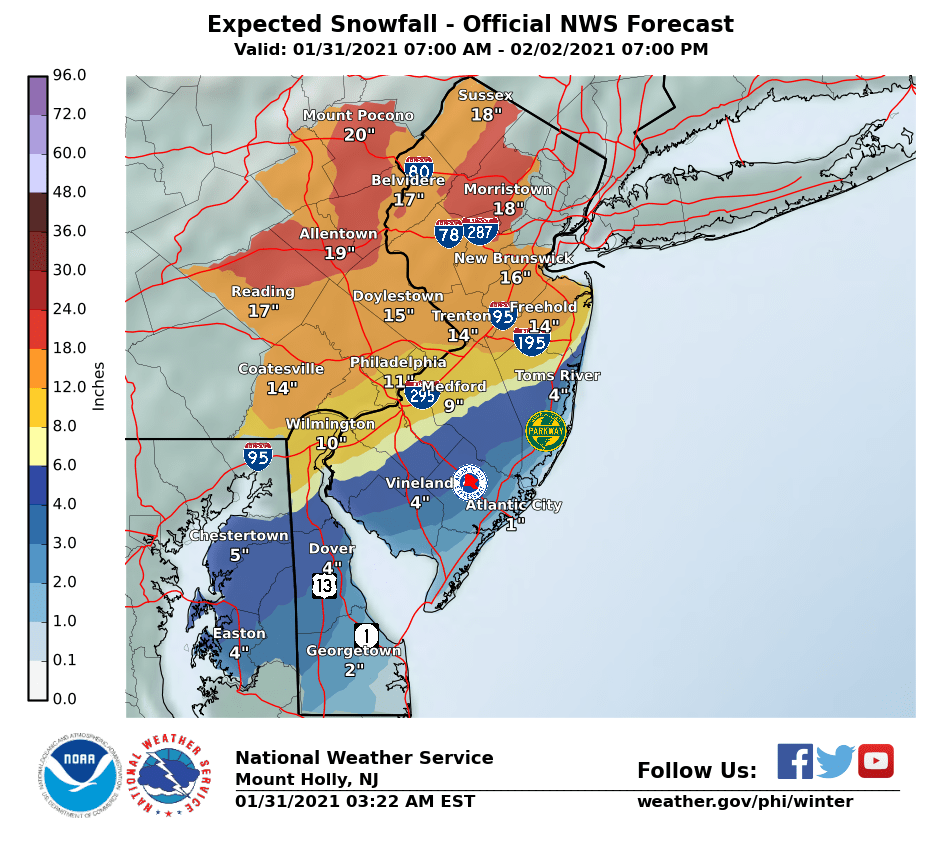
Not a bad prediction of what the NWS would do. They issued warnings for almost everywhere (Hunterdon, Mercer, Middlesex, Somerset is for 13-18") went to 12-18" for most of CNJ/NNJ/NYC/LI/NEPA, with 18-24" swaths embedded in that area and they also went up to 8-12" for south of 276/195 and less towards the coast. I like how they've worked up to this rather than going right to these amounts 24 hours ago, when they could have just based on models. Hard to imagine getting less than 12" along/NW of 95, from Trenton to NYC at this point or north of 195 and west of about Howell to Highlands.
Time for a prediction: I'll be bold and go for 19" at my house, which is roughly the average from the 0Z models tonight. Maybe not that bold looking at the latest 6Z NAM (21" for my house), 3KNAM (25") and RGEM (19"). I'm sure there will still be some surprises though - some will likely get more than what's shown (where the best bands are) and some will get less (especially if more rain/sleet mixes in for the coast and even towards 95, which can't be ruled out). And more or less precip could make a signficant difference, obviously. Time for some sleep, as I'm sure there's little sleep in store the next two nights.
https://www.weather.gov/phi/


@e5fdny - even more than I thought. And you're forecast for more, too...It's going to trend upward in about 2 hours, guaranteed.
The NWS for my area says something similar.
It has actually trended downward since I last checked.
I'm cool with that. 😎
I'm not all that concerned with snow, it's the flooding I look at. Right now it's trending toward my car having a two day vacation in a town parking lot. The only problem with that is I then have to dig it out afterwards.
Two cans cans tied to a string on their horse and buggy = car phonesThe village elders may have to have you shunned for that remark...
2 of the 3 locals and Good Morning America have pulled back and now saying 6-10 for the 95 area around Philly.
And have increased numbers in north Jersey. We originally were looking at 6-10 now we are at 14-18. I will gladly send some down south if you would like😎2 of the 3 locals and Good Morning America have pulled back and now saying 6-10 for the 95 area around Philly.
The NWS for my area says something similar.
It has actually trended downward since I last checked.
I'm cool with that. 😎
OK by me too. glad there's so little down here, although working up in Clark ain't going to happen tomorrow. Hoping for Tuesday.
6z models still showing 14-24 inches for all of the northern half to two-thirds of NJ, with higher amounts generally focused on Morris County, northern Somerset and Hunterdon Counties, Warren County, and Sussex County
We always get the most snow in NW NJ compared to other areas of the state.
We always get the most snow in NW NJ compared to other areas of the state.
Long Valley thru Mt Olive and into Sussex always seemed to get the worst when I lived up that way.
Long Valley thru Mt Olive and into Sussex always seemed to get the wrst when I lived up that way.
Def, and into West Milford too.
12z NAM is an absolute bomb for the northern half of NJ, with basically 18-24 inches from a line running from about Trenton to Belmar, and ALL points north.
East/central PA starting around Harrisburg, and all points NNE from there (Poconos) are in the same swath.
East/central PA starting around Harrisburg, and all points NNE from there (Poconos) are in the same swath.
Unfortunately, NWS upped their tidal flooding from minor with scattered moderate to widespread moderate...I'm not all that concerned with snow, it's the flooding I look at. Right now it's trending toward my car having a two day vacation in a town parking lot. The only problem with that is I then have to dig it out afterwards.
.TIDES/COASTAL FLOODING...
A coastal low will meander just offshore the NJ coast this Monday
into Tuesday and strong onshore flow is expected develop tonight and
continue through at least Monday night, before potentially acquiring
a more offshore component on Tuesday. Fairly widespread moderate
tidal flooding therefore looks likely over the NJ/DE coasts and
backbays for at least the Monday morning and evening high tides,
with some potential for flooding persisting into the Tuesday AM high
tide (but this is less certain given that the flow will be backing).
Consequently converted the Coastal Flood Watches to Warnings for the
NJ/DE coasts with this package.
There is also the potential for minor-to moderate tidal flooding
over portions of Delaware Bay, however confidence is a bit too low
at this time (and there is still technically 24 hours to the first
high tide cycle of interest) to upgrade. Therefore will retain the
watch there and the next shift can decide if it should be converted
to a warning or advisory.
Coastal Hazard Message
National Weather Service Mount Holly NJ
323 AM EST Sun Jan 31 2021
NJZ012>014-020-026-027-312130-
/O.UPG.KPHI.CF.A.0001.210201T1200Z-210202T2200Z/
/O.NEW.KPHI.CF.W.0001.210201T1200Z-210202T2200Z/
Middlesex-Western Monmouth-Eastern Monmouth-Ocean-Coastal Ocean-
Southeastern Burlington-
323 AM EST Sun Jan 31 2021
...COASTAL FLOOD WARNING IN EFFECT FROM 7 AM MONDAY TO 5 PM EST
TUESDAY...
* WHAT...One to two feet of inundation above ground level
expected in low-lying areas near shorelines and tidal
waterways.
* WHERE...Middlesex, Western Monmouth, Eastern Monmouth, Ocean,
Coastal Ocean and Southeastern Burlington.
* WHEN...From 7 AM Monday to 5 PM EST Tuesday.
* IMPACTS...At this level, widespread roadway flooding occurs in
coastal and bayside communities and along inland tidal
waterways. Many roads become impassable. Some damage to
vulnerable structures may begin to occur.
https://forecast.weather.gov/wwamap/wwatxtget.php?cwa=phi&wwa=coastal flood warning
Seems like I have a high degree of uncertainty living in Belmar since that appears to be a dividing line a significant snowfall and something featuring more of a mix of snow and rain. Wet heavy snow is the worst!
As is the 12Z RGEM and 3km NAM (higher resolution). All three models showing similar results as last night with the 12" line close to 276/195 with 12-20" north of there and some spots at 20-24" (especially N of 78). And the RGEM gets over a foot down through Phiilly; the others have 8-12" for Philly - Philly is a tough call as it will be on the SW edge of the heavy snows from the coastal. Could be 6" or 12" (or 15") - best guess 8-12" as per the NWS.12z NAM is an absolute bomb for the northern half of NJ, with basically 18-24 inches from a line running from about Trenton to Belmar, and ALL points north.
East/central PA starting around Harrisburg, and all points NNE from there (Poconos) are in the same swath.
12Z GFS continues to be a huge hit for the area and extends the heavy snow SW-ward with the 12" line being from about Wilmington to AC (less mixing and more precip), with Philly getting 24" (and everyone north of there getting at least 15-20" with many getting up to 24") - not a forecast, but people down there should not be assuming this is only a 6-10" storm - it might be, but the potential is there for much more.
Last edited:

When is this gonna end? Sometime on Tuesday?
Unfortunately, NWS upped their tidal flooding from minor with scattered moderate to widespread moderate...
.TIDES/COASTAL FLOODING...
A coastal low will meander just offshore the NJ coast this Monday
into Tuesday and strong onshore flow is expected develop tonight and
continue through at least Monday night, before potentially acquiring
a more offshore component on Tuesday. Fairly widespread moderate
tidal flooding therefore looks likely over the NJ/DE coasts and
backbays for at least the Monday morning and evening high tides,
with some potential for flooding persisting into the Tuesday AM high
tide (but this is less certain given that the flow will be backing).
Consequently converted the Coastal Flood Watches to Warnings for the
NJ/DE coasts with this package.
There is also the potential for minor-to moderate tidal flooding
over portions of Delaware Bay, however confidence is a bit too low
at this time (and there is still technically 24 hours to the first
high tide cycle of interest) to upgrade. Therefore will retain the
watch there and the next shift can decide if it should be converted
to a warning or advisory.
Coastal Hazard Message
National Weather Service Mount Holly NJ
323 AM EST Sun Jan 31 2021
NJZ012>014-020-026-027-312130-
/O.UPG.KPHI.CF.A.0001.210201T1200Z-210202T2200Z/
/O.NEW.KPHI.CF.W.0001.210201T1200Z-210202T2200Z/
Middlesex-Western Monmouth-Eastern Monmouth-Ocean-Coastal Ocean-
Southeastern Burlington-
323 AM EST Sun Jan 31 2021
...COASTAL FLOOD WARNING IN EFFECT FROM 7 AM MONDAY TO 5 PM EST
TUESDAY...
* WHAT...One to two feet of inundation above ground level
expected in low-lying areas near shorelines and tidal
waterways.
* WHERE...Middlesex, Western Monmouth, Eastern Monmouth, Ocean,
Coastal Ocean and Southeastern Burlington.
* WHEN...From 7 AM Monday to 5 PM EST Tuesday.
* IMPACTS...At this level, widespread roadway flooding occurs in
coastal and bayside communities and along inland tidal
waterways. Many roads become impassable. Some damage to
vulnerable structures may begin to occur.
https://forecast.weather.gov/wwamap/wwatxtget.php?cwa=phi&wwa=coastal flood warning
Yeah. I have an app on my phone from Stevens Tech that projects Tidal flooding. Usually really reliable. The Mon night tide is projected to be the worst. Right now I likely won't see much but if the projection gets worse and we have more snow than predicted, I'm stuck.
Better a slight inconvenience is my motto.
Nah. It's just moved back to your house. ; )I leave the board for a day and come back to this "reasonable" map?????
WTF!
Guess daycare will be closed on Monday.
Beach Webcams in New Jersey - NJ Beach Cams
Live Beach Webcams in New Jersey , NJ Weather and Beach Conditions for Surf Spots at the Jersey Shore. Browse through our full list of Live New Jersey Beach Cams including NJ's best Beaches and boardwalks that are live and Streaming 24/7!
The village elders may have to have you shunned for that remark...
Had to click to see what he said for he was already pre-shunned.
When is this gonna end? Sometime on Tuesday?
Just keep shoveling until the bright orange ball in the sky returns.
- Status
- Not open for further replies.
Similar threads
- Replies
- 44
- Views
- 2K
- Replies
- 87
- Views
- 3K
- Replies
- 152
- Views
- 7K
ADVERTISEMENT
ADVERTISEMENT