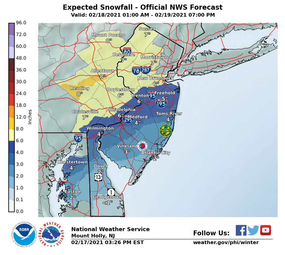
Dave Curran News 12 says New Brunswick Manville Somerset Princeton Trenton areas will definitely see 8 inches.


Colleges
- American Athletic
- Atlantic Coast
- Big 12
- Big East
- Big Ten
- Colonial
- Conference USA
- Independents (FBS)
- Junior College
- Mountain West
- Northeast
- Pac-12
- Patriot League
- Pioneer League
- Southeastern
- Sun Belt
- Army
- Charlotte
- East Carolina
- Florida Atlantic
- Memphis
- Navy
- North Texas
- Rice
- South Florida
- Temple
- Tulane
- Tulsa
- UAB
- UTSA
- Boston College
- California
- Clemson
- Duke
- Florida State
- Georgia Tech
- Louisville
- Miami (FL)
- North Carolina
- North Carolina State
- Pittsburgh
- Southern Methodist
- Stanford
- Syracuse
- Virginia
- Virginia Tech
- Wake Forest
- Arizona
- Arizona State
- Baylor
- Brigham Young
- Cincinnati
- Colorado
- Houston
- Iowa State
- Kansas
- Kansas State
- Oklahoma State
- TCU
- Texas Tech
- UCF
- Utah
- West Virginia
- Illinois
- Indiana
- Iowa
- Maryland
- Michigan
- Michigan State
- Minnesota
- Nebraska
- Northwestern
- Ohio State
- Oregon
- Penn State
- Purdue
- Rutgers
- UCLA
- USC
- Washington
- Wisconsin
High School
- Illinois HS Sports
- Indiana HS Sports
- Iowa HS Sports
- Kansas HS Sports
- Michigan HS Sports
- Minnesota HS Sports
- Missouri HS Sports
- Nebraska HS Sports
- Oklahoma HS Sports
- Texas HS Hoops
- Texas HS Sports
- Wisconsin HS Sports
- Cincinnati HS Sports
- Delaware
- Maryland HS Sports
- New Jersey HS Hoops
- New Jersey HS Sports
- NYC HS Hoops
- Ohio HS Sports
- Pennsylvania HS Sports
- Virginia HS Sports
- West Virginia HS Sports
ADVERTISEMENT
Install the app
How to install the app on iOS
Follow along with the video below to see how to install our site as a web app on your home screen.
Note: This feature may not be available in some browsers.
You are using an out of date browser. It may not display this or other websites correctly.
You should upgrade or use an alternative browser.
You should upgrade or use an alternative browser.
OT: Significant Winter Storm Likely on Thursday (2/18)
- Thread starter RU848789
- Start date

Dave Curran News 12 says New Brunswick Manville Somerset Princeton Trenton areas will definitely see 8 inches.
wow that is a pretty ballsy move since most models have 8 has their highest range currently
This has bust written all over it and it's not really the WFO's fault. This is basically unforecastable.
that the NWS is so detailed and with some many caveats shows that they are concerned....kudos to them though for at least going in detail on what could happen
wow that is a pretty ballsy move since most models have 8 has their highest range currently
Has Somerset County in the 7-9 range. Says it will snow heavily in a band along the NJ Turnpike.
Not really - the heaviest snow is likely to be over by late Thursday afternoon. Shovel then and whatever falls after that will melt on Saturday with temps a bit above 32F and full sun.The weather channel has the snow starting at 6am Thursday going until 7pm Thursday and changing to rain from 7pm until 8pm back to snow at 9 and then back to rain from then until 4am Friday and then snow until 3pm Friday for Jackson
So this looks like a shovel multiple times over the 2 days
If they give this storm a name Sybil would be a suitable choice.The weather channel has the snow starting at 6am Thursday going until 7pm Thursday and changing to rain from 7pm until 8pm back to snow at 9 and then back to rain from then until 4am Friday and then snow until 3pm Friday for Jackson
So this looks like a shovel multiple times over the 2 days
The weather channel has the snow starting at 6am Thursday going until 7pm Thursday and changing to rain from 7pm until 8pm back to snow at 9 and then back to rain from then until 4am Friday and then snow until 3pm Friday for Jackson
So this looks like a shovel multiple times over the 2 days
darn... my back is going to be tested again.
Seriously? That's like asking me if I want some scotch with that splash of water.Would you like some hookers and blow with that order sir?
It's an impossible forecast to get right for most people. That's why I like the forecaster's bottom line comment: "Bottom line here: This is incredibly challenging to forecast in advance and will likely not become clear until the event is unfolding." We're likely not going to know what's likely to happen until, well, it's happening.that the NWS is so detailed and with some many caveats shows that they are concerned....kudos to them though for at least going in detail on what could happen
Finally, I always like to guess what I'll get in any storm and have had some very good luck so far (predicted 14" for 12/16 and got ~10", predicted 19" for 2/1 and got 18", predicted 6" for 2/7 and got 6", and predicted 3" for 2/11 and got 2.75"). However, I have no clue about this one. Before today, I was thinking this was going to be a fairly mundane 6" thump for Metuchen and most of CNJ - now, who knows? Just for fun, I'll go with 3.5" of snow, then 1" of sleet (3" snow equivalent) on Thursday, then 1.5" of snow on Friday over a long period, but it could be 8" of all snow or 1" of snow, then 1.5" of sleet (~4.5" snow equivalent in mass) and 0.25" of freezing rain (2.5" snow equivalent), too. All three of those scenarios are 8" of snow equivalent at 10:1 (or 0.8" liquid equivalent), which is on the high side of the model forecasts, but rolling the dice, lol.
Hey @RUJohnny - what are your thoughts now?
Last edited:
NWS
Another round of winter weather is on the way! Winter Storm Warnings and Advisories have been issued for much of the region. Hazardous conditions are likely for most of the day Thursday and potentially into early Friday. An updated briefing is available at the link,


Another round of winter weather is on the way! Winter Storm Warnings and Advisories have been issued for much of the region. Hazardous conditions are likely for most of the day Thursday and potentially into early Friday. An updated briefing is available at the link,
>95% of people won't read the discussion and just want the headline..."how much snow am i going to get, and when?"that the NWS is so detailed and with some many caveats shows that they are concerned....kudos to them though for at least going in detail on what could happen
some of us will now read it only because of this message board
Also, some models are only showing about 0.4-0.5" of total precip (4-" of snow) along 95 and even less NW...This has low end bust written all over it and it's not really the WFO's fault. This is basically unforecastable.
Could easily see this being mostly sleet south of 78. Warm mid level layers always end up being more North than model guidance shows.
And adding to it!Yeah, I hear ya. Just my way of commenting on the large amount of bickering that's been going on.
Slammed at work and know the models are waffling and I know why, but I won't have time to try to figure out which ones are right for a while and not looking forward to it 😛It's an impossible forecast to get right for most people. That's why I like the forecaster's bottom line comment: "Bottom line here: This is incredibly challenging to forecast in advance and will likely not become clear until the event is unfolding." We're likely not going to know what's likely to happen until, well, it's happening.
Before today, I was thinking this was going to be a fairly mundane 6" thump for Metuchen and most of CNJ - now, I have no clue. Just for fun, I'll go with 3.5" of snow, then 1" of sleet (3" snow equivalent) on Thursday, then 1.5" of snow on Friday over a long period, but it could be 8" of all snow or 1" of snow 1.5" of sleet (~4.5" snow equivalent in mass) and 0.25" of freezing rain (2.5" snow equivalent), too. All three of those scenarios are 8" of snow equivalent.
Hey @RUJohnny - what are your thoughts now?
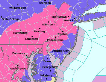
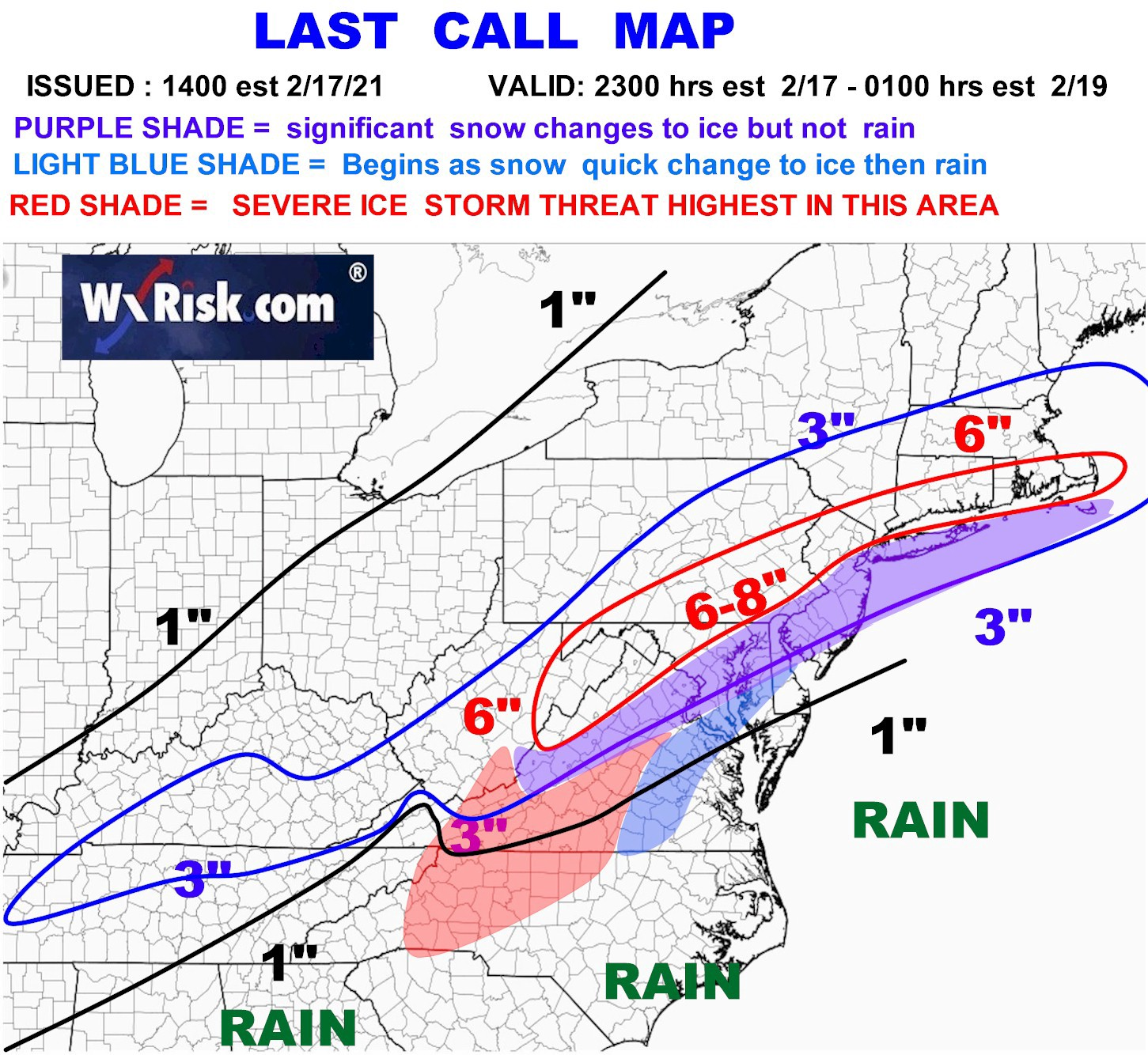
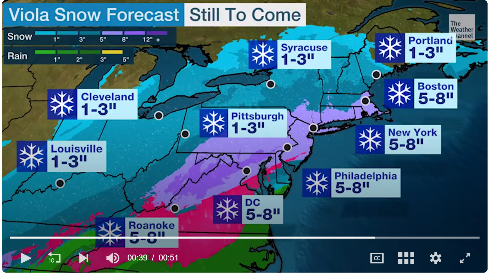
Bumping this as it now has the current maps...which I reproduced below. I friggin' can't stand how hard it is to cut and paste simple links and images on this site.Talk about complex. Just read the NWS-Philly discussion below. Could be 4-8" of snow for most, hence the warnings along and NW of 95 from DE to Middlesex County or it could be 2" of snow and 1-2" of sleet (same mass as 3-6" of snow) for much of the 95 corridor. Could also be less snow NW due to less precip, cancelled out by more snow due to high ratios. And that's not even getting into whether areas along and SE of 95 will see a change to freezing rain, which up to 1/4" modeled for some, especially in SNJ. This is one of the hardest forecasts these guys will ever have to make. I liked the bottom line below in bold.
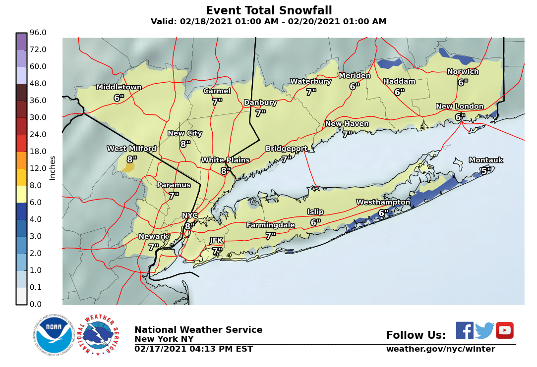
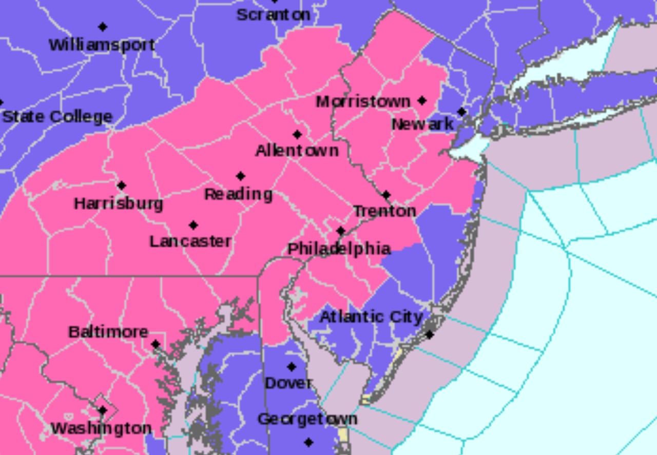
Also, fascinating that NWS-NYC went just with advisories for slightly more snow (5-9" through Friday, but only 3-6" for Thursday), but because it's over 30 hours, as per my comments above. Map of warnings (pink) and advisories (blue) is below; still waiting on the NYC snowfall map.
Area Forecast Discussion
National Weather Service Mount Holly NJ
330 PM EST Wed Feb 17 2021
.SYNOPSIS...
High pressure will shift northeastward into New England tonight. Low
pressure tracking out of the Gulf Coast region will pass just off
the mid-Atlantic coast late Thursday into early Friday before departing
out to sea. Strong high pressure builds into the region over the
weekend. A frontal system approaching from the west will move quickly
through the mid-Atlantic on Monday, and renewed high pressure will
likely build in by the middle of next week.
&&
.NEAR TERM /THROUGH THURSDAY/...
It seems there is never a simple winter-weather event in this part
of the country...
A very complex upper pattern will unfold over the next 24 hours. A
large-scale trough in the Rockies with several embedded
perturbations will progress eastward into the Plains by 00z Friday.
The southern stream will feature one vort max ejecting northeastward
from the southern Plains this evening to the eastern Great Lakes and
Saint Lawrence Valley Thursday night, while shearing in the
confluent midlevel flow downstream. A second southern-stream
shortwave trough will dig from the Desert Southwest to southern
Texas during the same time, which will have impacts on the Thursday
night/Friday period for our area. Meanwhile, two northern-stream
perturbations will race southeastward from the Canadian Rockies to
the Upper Midwest and vicinity.
The ultimate evolution of the first southern-stream perturbation
will be what is responsible for our winter weather late tonight and
Thursday. A strong anticyclonic upper-level jet streak will combine
with midlevel differential cyclonic vorticity advection to aid in
intensifying surface low pressure from the northern Gulf of Mexico
tonight to the Mid-Atlantic coast Thursday afternoon. Intense warm
advection atop a low-level baroclinic zone will aid in widespread
precipitation to the north and northeast of the developing low.
Meanwhile, a strong surface high will remain in southeast Canada,
providing cold onshore flow for the northern Mid-Atlantic preceding
the storm. Models are, as usual, too moist with the predecessor
boundary-layer environment, with dew points a good 6-10+ degrees
lower than model consensus today. This will be important in two
ways. First, it is likely that low-level saturation requirements
will delay precipitation onset in our CWA, with snow not likely to
get going in earnest until near or just after daybreak. Second,
models are likely too warm at the surface, especially during the
main "thump" of precipitation during the morning hours. Sided with
colder guidance here.
With models trending slightly northward with the warm-nose influence
on precipitation type on Thursday, our inclination was to be a
little less aggressive than consensus in this regard. No question
that the strength of warm advection will be intense, likely leading
to a veritable sleet storm in a good chunk of the area as the event
unfolds during the day. However, there has been a tendency for
higher-res guidance to be a little too aggressive in shunting the
warm nose to the north this season. Of course, there has also been a
tendency for northwest shifts in the snow/sleet/freezing rain
geographical distributions within 24 hours of the event (playing out
once again with today's guidance). It will be quite interesting to
see how the 00z solutions play out, as run-to-run variability has
been diminishing confidence in the forecast for this event
considerably.
Adding to the uncertainty here is the highly sensitive nature of the
low-level thermodynamic profiles. Model soundings indicate a rather
deep layer with temperatures close to freezing during precipitation
onset (generally between 900 and 700 mb). The warm nose will be
quite elevated, especially near the urban corridor, which suggests
that sleet will be the primary precipitation type should transition
from the initial burst of snow occur. However, precipitation rates
will be critical in the ultimate evolution of precipitation type,
with models showing such marginal conditions for a long period of
time that it would not surprise us to see variable conditions for
much of the late morning and afternoon hours in a wide sector of the
CWA. Precipitation type may vary from snow to sleet to snow to sleet
in the urban corridor for several hours, with total snow
accumulations quite dependent on the ratio of "snow time" to "sleet
time". Meanwhile, in portions of Delmarva and southern New Jersey,
some mixing with freezing rain and plain rain will likely occur
during the afternoon. Bottom line here: This is incredibly
challenging to forecast in advance and will likely not become clear
until the event is unfolding.
Finally, there is also the "daytime" timing, which is not
particularly favorable for snow accumulations now that we are in the
waning portions of winter. However, the strong lift via
frontogenetical forcing (and strong upper divergence) suggest that
formidable snowfall rates could occur once the heavier snow begins,
with HREF probabilities of 30-50+ percent with snowfall exceeding
one inch per hour in much of the area between 12z and 18z and mean 1-
hour snow accumulations of 0.5-0.75 inches. Should these snow rates
materialize, rapid accumulation would occur despite the unfavorable
diurnal timing.
Weighing all of these factors, hoisted a winter storm warning for
the urban corridor and northwestward and a winter weather advisory
to the southeast, with snow totals generally 4 to 8 inches (higher
amounts northwest of the Fall Line) in the warning and 1 to 4 inches
in the advisory. The warning may end up being quite marginal with
the technical thresholds, but am worried about the initial burst of
precipitation Thursday morning as well as combined effects of
various precipitation types. Some icing may occur in Delmarva and
southern New Jersey, though impacts will likely be mitigated by
marginal surface temperatures. Confidence is quite low in totals
along the I-95 corridor and about 20-40 miles either side, owing to
the precipitation type complications discussed. Precipitation will
likely diminish quickly during the late afternoon as a dry slot
moves into the region, but this sets the stage for round 2 of the
event...
.SHORT TERM /THURSDAY NIGHT THROUGH FRIDAY NIGHT/...
The forecast for Thursday night and Friday is of unusually low
confidence owing to quite disparate deterministic 12z model
solutions regarding southern-stream perturbation number 2. It is
expected that the steadier precipitation from the southern-stream
system impacting us during the day will be to our east Thursday
night. However, low levels will likely remain saturated, leading to
the potential for a lengthy period of light snow (mainly northwest
of the Fall Line) and a light wintry mix farther southeast. In fact,
there may be a lengthy period of freezing drizzle in far southeast
PA, central/southern NJ, and portions of Delmarva. With temperatures
likely continuing below freezing, better ice accretion may occur on
the south side of the winter storm warning and in the winter weather
advisory areas. Thus, have kept the products going through the
morning rush on Friday, despite precipitation rates expected to be
far lower than the daytime Thursday.
The precipitation may linger into the day Friday, but models are all
over the place here, with the NAM basically dry, the GFS/ECMWF
fairly wet, and several hi-res models in between. Basically
implemented consensus for now, and extended the WWAs far enough to
allow for potential extension into more of Friday if required.
Temperatures will likely be flirting with freezing (or higher) in
much of the area southeast of the Fall Line, as well, so it is not
entirely clear where rain versus snow would occur in this scenario.
thanksNot really - the heaviest snow is likely to be over by late Thursday afternoon. Shovel then and whatever falls after that will melt on Saturday with temps a bit above 32F and full sun.
The weather channel has the snow starting at 6am Thursday going until 7pm Thursday and changing to rain from 7pm until 8pm back to snow at 9 and then back to rain from then until 4am Friday and then snow until 3pm Friday for Jackson
According to your description, if this storm changes its form of precipitation just two more times, it will equal the number of times Bac has flip flopped on mask usage. If that happens, the storm can officially be named after him.
In case anyone is curious to hear the explanation for the NWS-NYC going with advisories vs. warnings, it was basically what I said in my earlier post - it's duration related.
Area Forecast Discussion
National Weather Service New York NY
440 PM EST Wed Feb 17 2021
Overall, trends are for this to be a long duration (36 hr) light to
moderate snowfall event, with most snowfall occurring on
Thursday, and additional light snow Thu Night into Friday,
resulting in a widespread final accumulations of 5-9" over
24-36 hours. Confidence is not high in a widespread more than
6" in 12hrs or 8" in 24 hrs. For this reason winter weather
advisory has been hoisted for Thu/Fri time period, and not a warning.
Overall, not too bad. After a 20 inch storm, what’s another 6?Bumping this as it now has the current maps...which I reproduced below. I friggin' can't stand how hard it is to cut and paste simple links and images on this site.
Dave Curran just reiterated that Somerville Hillsborough Princeton to Liden will get a solid 8 inches. Let's see if he holds true.
Dave Curran just reiterated that Somerville Hillsborough Princeton to Liden will get a solid 8 inches. Let's see if he holds true.
Liden? Do you mean Linden?
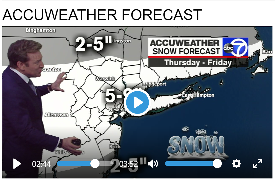
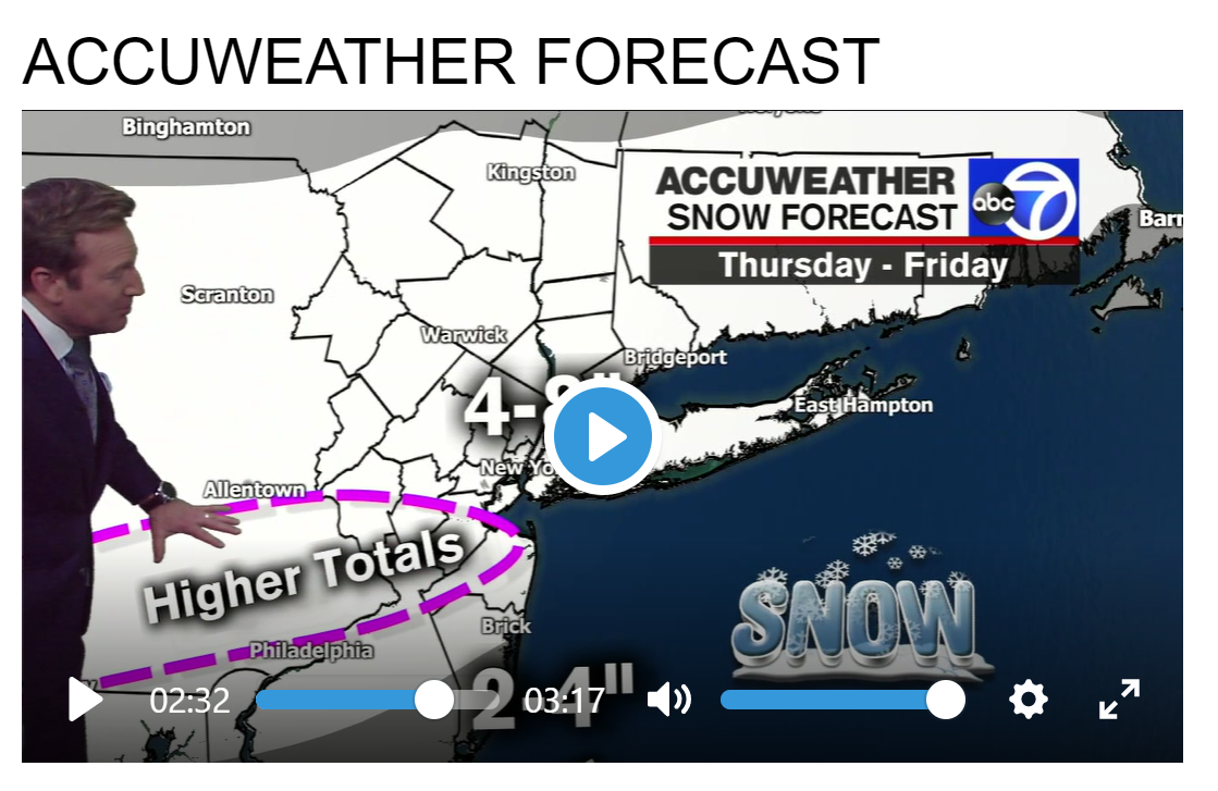
Adding a few more forecasts for the area, all of which are fairly consistent with the 4-7"/5-9" forecasts we've seen from the NWS for most of the area through Friday (with more like 3-6" on Thursday). Ok, poker night - see y'all after midnight - behave yourselves until then...Bumping this as it now has the current maps...which I reproduced below. I friggin' can't stand how hard it is to cut and paste simple links and images on this site.
NWS
This storm won't be especially big in terms of amounts, but there is potential for a period of high snowfall rates tomorrow morning and early afternoon. Also, tonight's cold temperatures will help snow to stick as it falls especially on untreated surfaces. This model shows a projected hourly snowfall rate at 11AM Thursday morning; it is showing snowfall of around 1 inch per hour in much of the urban corridor, which we think is a reasonable expectation!

This storm won't be especially big in terms of amounts, but there is potential for a period of high snowfall rates tomorrow morning and early afternoon. Also, tonight's cold temperatures will help snow to stick as it falls especially on untreated surfaces. This model shows a projected hourly snowfall rate at 11AM Thursday morning; it is showing snowfall of around 1 inch per hour in much of the urban corridor, which we think is a reasonable expectation!
Winter storm warnings issued across most of state, with heavy snow and dangerous driving conditions expected
Latest forecast, snow predictions, storm warnings and winter weather advisories across New Jersey.
Why yes, my good man. That would be quite splendid indeed.Would you like some hookers and blow with that order sir?
Although never while driving, of course.
I feel compelled to point out that, in reality, I've never actually been with a hooker. So... does that mean you've never actually taken a splash of water with your scotch?Seriously? That's like asking me if I want some scotch with that splash of water.
I mean, what guy here hasn't promised that, now and then?Dave Curran News 12 says New Brunswick Manville Somerset Princeton Trenton areas will definitely see 8 inches.
Lonnie Quinn didn't have sleeves rolled up. Not a serious storm. Had his jacket off though, likely signifying a slightly concerning event.
Technically you're probably correct. But since you have to buy your sheep.......I feel compelled to point out that, in reality, I've never actually been with a hooker.
Stop with your wishcasting. This has bust written all over it.NWS
This storm won't be especially big in terms of amounts, but there is potential for a period of high snowfall rates tomorrow morning and early afternoon. Also, tonight's cold temperatures will help snow to stick as it falls especially on untreated surfaces. This model shows a projected hourly snowfall rate at 11AM Thursday morning; it is showing snowfall of around 1 inch per hour in much of the urban corridor, which we think is a reasonable expectation!
Electric snowblower event
EGO 2 stage blower can handle a lot of snow.Stop with your wishcasting. This has bust written all over it.
Electric snowblower event
Dave Curran News 12 says New Brunswick Manville Somerset Princeton Trenton areas will definitely see 8 inches.
He's better than Dan Zarrow
Dave is not the best, IMO. He was way low on 2/1 and low on 2/7 and I think he's now too high on this one. But he loves snow and is at least entertaining - he was doing snow angels on camera during the big storm on 2/1, which was pretty funny and he does interesting remotes from his house.Dave Curran just reiterated that Somerville Hillsborough Princeton to Liden will get a solid 8 inches. Let's see if he holds true.
Adding a few more forecasts for the area, all of which are fairly consistent with the 4-7"/5-9" forecasts we've seen from the NWS for most of the area through Friday (with more like 3-6" on Thursday). Ok, poker night - see y'all after midnight - behave yourselves until then...
Well, it was a good night of poker (won over $200) and the 0Z models tonight didn't really change that much from earlier, except there is a bit more consensus with less models showing only 2-3" in the front end thump and most models showing most of the snow being over by 7 pm Thursday, with generally only 1-2" after that in most models, from late Thursday through about noon Friday.
Can't imagine the NWS or other forecasters making much change to whatever forecasts they have based on this. Looks like 4-8" is a pretty good call for most with the wild card being sleet, which could be substantial SE of 95 and even up to the 95 corridor, but the models aren't showing much plain rain at all except for extreme SE NJ (like south of AC), where some freezing rain could also fall.
Snow looks like it arrives around sunrise, but likely not heavy in CNJ until mid-morning. Time to watch the radar and short-term/high-res models. One last forecast update from Lee Goldberg (my favorite NYC met), who is pretty well aligned with the NWS on this one.
Similar threads
- Replies
- 62
- Views
- 2K
- Replies
- 608
- Views
- 18K
OT: Minor to Moderate (2-4?) Snowfall Likely Sat morning (2/17); will be <32F, so expect slick roads
- Replies
- 213
- Views
- 5K
- Replies
- 592
- Views
- 16K
ADVERTISEMENT
Latest posts
-
 Basketball Knights in the W: Tracking former Rutgers Women's Hoops stars in the WNBA
- Latest: Alec Crouthamel
-
-

ADVERTISEMENT