NWS map from 4 pm says 6" for Philly, so let's go with 6". Philly will not have an accumulationn problem as it'll be below 32F so everything should accumulate. The only thing that keeps Philly below 4-5", to me, is sleet mixing in, which is definitely possible I'm in the minority who thinks we should measure frozen mass, so getting 3" of snow and 1" of sleet (3" of snow worth) has about the same impact as 6" of snow (except for visibility issues), even though it's only 3-4" in depth (the sleet can compact the snow).So 5 is the number for Philly?


Colleges
- American Athletic
- Atlantic Coast
- Big 12
- Big East
- Big Ten
- Colonial
- Conference USA
- Independents (FBS)
- Junior College
- Mountain West
- Northeast
- Pac-12
- Patriot League
- Pioneer League
- Southeastern
- Sun Belt
- Army
- Charlotte
- East Carolina
- Florida Atlantic
- Memphis
- Navy
- North Texas
- Rice
- South Florida
- Temple
- Tulane
- Tulsa
- UAB
- UTSA
- Boston College
- California
- Clemson
- Duke
- Florida State
- Georgia Tech
- Louisville
- Miami (FL)
- North Carolina
- North Carolina State
- Pittsburgh
- Southern Methodist
- Stanford
- Syracuse
- Virginia
- Virginia Tech
- Wake Forest
- Arizona
- Arizona State
- Baylor
- Brigham Young
- Cincinnati
- Colorado
- Houston
- Iowa State
- Kansas
- Kansas State
- Oklahoma State
- TCU
- Texas Tech
- UCF
- Utah
- West Virginia
- Illinois
- Indiana
- Iowa
- Maryland
- Michigan
- Michigan State
- Minnesota
- Nebraska
- Northwestern
- Ohio State
- Oregon
- Penn State
- Purdue
- Rutgers
- UCLA
- USC
- Washington
- Wisconsin
High School
- Illinois HS Sports
- Indiana HS Sports
- Iowa HS Sports
- Kansas HS Sports
- Michigan HS Sports
- Minnesota HS Sports
- Missouri HS Sports
- Nebraska HS Sports
- Oklahoma HS Sports
- Texas HS Hoops
- Texas HS Sports
- Wisconsin HS Sports
- Cincinnati HS Sports
- Delaware
- Maryland HS Sports
- New Jersey HS Hoops
- New Jersey HS Sports
- NYC HS Hoops
- Ohio HS Sports
- Pennsylvania HS Sports
- Virginia HS Sports
- West Virginia HS Sports
ADVERTISEMENT
Install the app
How to install the app on iOS
Follow along with the video below to see how to install our site as a web app on your home screen.
Note: This feature may not be available in some browsers.
You are using an out of date browser. It may not display this or other websites correctly.
You should upgrade or use an alternative browser.
You should upgrade or use an alternative browser.
OT: Significant Winter Storm Likely on Thursday (2/18)
- Thread starter RU848789
- Start date
Bumping this as it now has the current maps...which I reproduced below. I friggin' can't stand how hard it is to cut and paste simple links and images on this site.
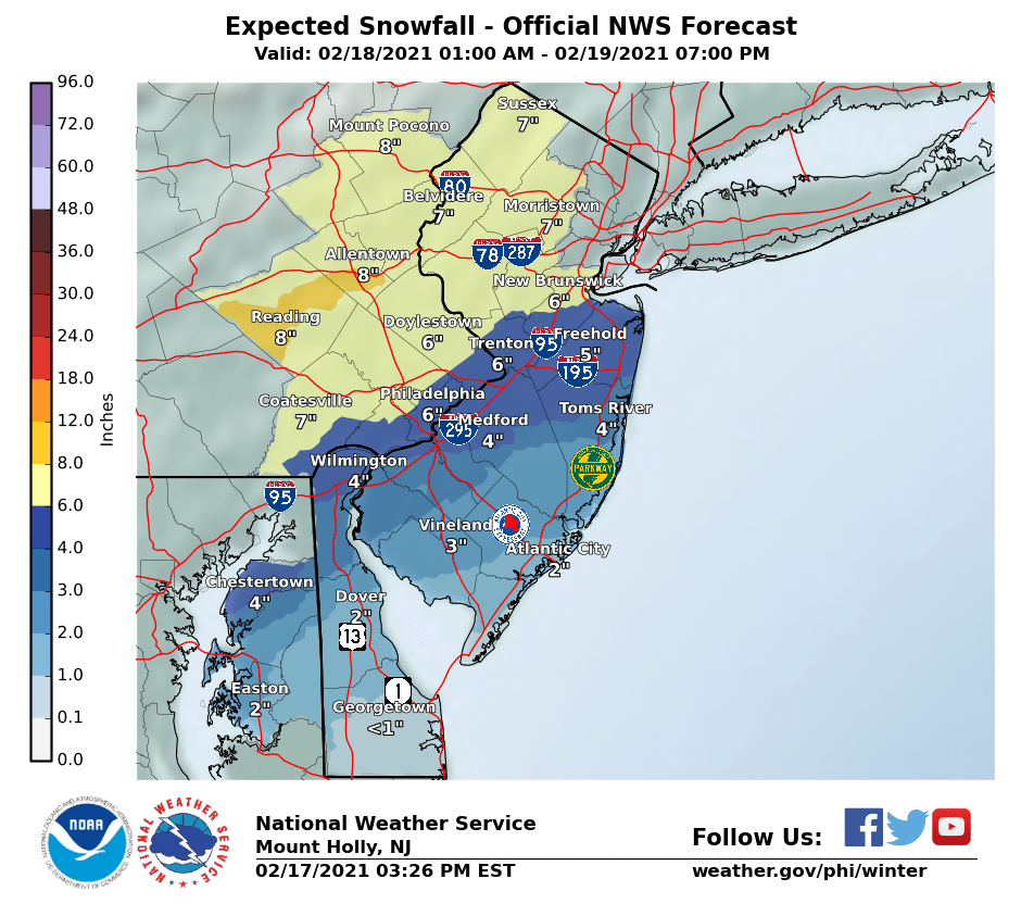
Slept 2 hours and woke up, lol. Mt. Holly cut back a little (maybe 1") in some places, but not all on both the map and in the warnings ("4-6 inches with locally higher amounts" now for most). On the flip side, Channel 7 increased their general snowfall for the entire area from 4-8" to 5-9". Sleet is still a significant risk to these snowfall amounts, especially south of 276/195 and SE of the NJ TPK from 195 up to about the Raritan. And the 6Z NAM just came out and shows 4-7" N for most during Thursday with another 2-3" falling on Friday morning, for 6-10" for most from Philly to LBI and north of there. That's just one model though and others will be out shortly. In addition, radar is juicier than previously modeled and it looks like accumulating snow will arrive by 6 am for most of CNJ, which is an hour or two earlier than expected. Nap time for now.
Last edited:

Sent this to my distro list last night. I'm a little lower than consensus.
| ||||||
|
Snow just started here in Metuchen around 6:40 am with a dusting on the ground already - looks like pixie dust out there. 27F. Lots of reports of people in the Philly area with 2" already and someone in Hamilton reported 2", but I hear there's sleet in areas like Glassboro - don't want to see sleet...
Also I am an outlier on axis of greatest accumulation which I have south of wxrisk, nws, News12. Jeff smith sees it my way. Not because he agrees with me but I think he's an excellent forecaster.Sent this to my distro list last night. I'm a little lower than consensus.
More Winter Weather on Thursday
A long duration winter weather event is unfolding as we approach the beginning of Thursday. Over the past 24 hours, upper level features have become a bit more strung out and... sloppy, for the lack of a better word. As a result we are going to see multiple waves of weak low pressure slide southeast of New Jersey, bringing what may end up being distinct periods of wintry precipitation with lulls in between. Besides the periods and intensity of precipitation, p-type is tricky as well.
As of midnight we see strong high pressure to our north. If you were out today, you know the cold has a bite to it. I downplayed the freezing rain event earlier this week, partly because the air mass was "stale." This one is fresh biscuits, and as the waves of low pressure advance, high pressure will slide north, not east, keeping us cold enough at the surface for frozen precipitation.
Aloft looks like a different story. The NAM model has a layer of warm air above freezing aloft, just a couple hours after precipitation moves in. Verbatim that is a sleety look for the southern half of the state. Warm enough aloft to melt snowflakes into liquid, surface and lower level cold enough for them to refreeze into sleet on the final descent down.
I'm not sure talking about accumulations has its usual utility this time around. There's a big different in 6" that falls in 8 hours like the Super Bowl storm, and 6" that falls over 30 hours like this strung out mess of weak low pressure waves. So here is my attempt to explain what I think happens-
Snow moves in around daybreak, southwest to northeast, reaching Bergen County and NYC by late morning. This period, from roughly 7am to 2pm, brings the best chance of moderate to heavy snow as the warm air aloft shoves up against the Arctic cold. When you see the flakes getting big and sticking together, the switch to sleet is right behind. Somewhere in central NJ, the warm air aloft will advance no further, and those just north of the snow/sleet line will pick up additional accumulation relative to those south who see mixing, and those north who will miss on the better atmospheric lift.
The changeover to sleet and eventually plain rain will creep through southern and central New Jersey as the morning goes on, and I wouldn't be surprised if we flip to sleet statewide early afternoon when the heavier precipitation moves east to Long Island and southern New England. Precipitation could end completely by end of day Thursday As a second wave of low pressure passes by Thursday night, winds back to the north, the column aloft cools, and any remaining precipitation will again be snow. That's dependent on how much lift and moisture remains at that point as we move into Friday. Honestly, I don't know. It could just be cloudy with flurries, or we could pick up another couple of inches in places. That will be more clear tomorrow.
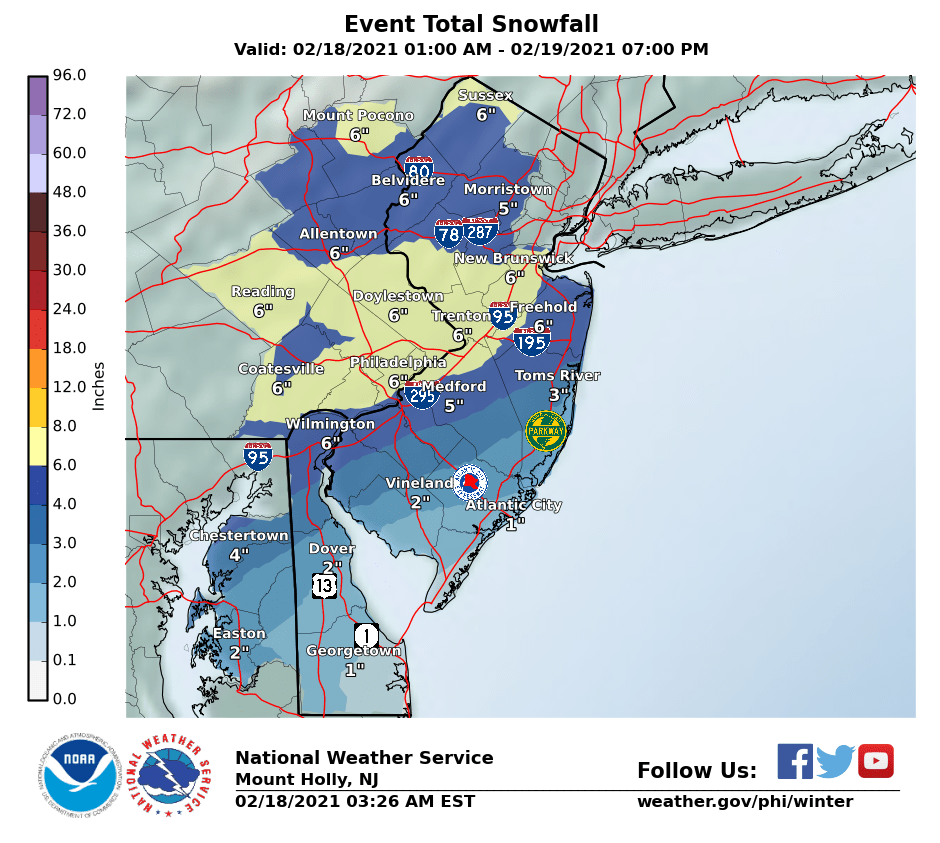
Yesterday I was thinking the max snow axis would be 6-10" and I'm going to pare that down to 4-8" for a stripe in central NJ. This is likely to be in the Mercer-Monmouth-Middlesex region, and northern Burlington, and maybe southern Hunterdon and Somerset too. Expect 4-6" everywhere to the north of there including the 78 and 80 corridors. South of the heaviest axis, expect 3-6" except in Cape May, Cumberland, and Atlantic Counties. There, 2-4" and a flip to sleet and rain by late morning.
This is all the totals for Thursday only. If there will be accumulations Friday, I will share a forecast Thursday covering them.
Warm Regards,
John Cifelli #NJWX
Snow started falling and fairly heavily down here at the south end of Rt. 34. in the past half hour.
Great write-up! I'm thinking the initial thump might overperform between about 276/195 and 78, as long as no sleet mixes in, but it's a risk, especially near and not too far N of 195 in NJ. Loved the "I don't know" part about round two, as models are seriously schizo on that one with everything from nada to 3".Sent this to my distro list last night. I'm a little lower than consensus.
More Winter Weather on Thursday
A long duration winter weather event is unfolding as we approach the beginning of Thursday. Over the past 24 hours, upper level features have become a bit more strung out and... sloppy, for the lack of a better word. As a result we are going to see multiple waves of weak low pressure slide southeast of New Jersey, bringing what may end up being distinct periods of wintry precipitation with lulls in between. Besides the periods and intensity of precipitation, p-type is tricky as well.
As of midnight we see strong high pressure to our north. If you were out today, you know the cold has a bite to it. I downplayed the freezing rain event earlier this week, partly because the air mass was "stale." This one is fresh biscuits, and as the waves of low pressure advance, high pressure will slide north, not east, keeping us cold enough at the surface for frozen precipitation.
Aloft looks like a different story. The NAM model has a layer of warm air above freezing aloft, just a couple hours after precipitation moves in. Verbatim that is a sleety look for the southern half of the state. Warm enough aloft to melt snowflakes into liquid, surface and lower level cold enough for them to refreeze into sleet on the final descent down.
I'm not sure talking about accumulations has its usual utility this time around. There's a big different in 6" that falls in 8 hours like the Super Bowl storm, and 6" that falls over 30 hours like this strung out mess of weak low pressure waves. So here is my attempt to explain what I think happens-
Snow moves in around daybreak, southwest to northeast, reaching Bergen County and NYC by late morning. This period, from roughly 7am to 2pm, brings the best chance of moderate to heavy snow as the warm air aloft shoves up against the Arctic cold. When you see the flakes getting big and sticking together, the switch to sleet is right behind. Somewhere in central NJ, the warm air aloft will advance no further, and those just north of the snow/sleet line will pick up additional accumulation relative to those south who see mixing, and those north who will miss on the better atmospheric lift.
The changeover to sleet and eventually plain rain will creep through southern and central New Jersey as the morning goes on, and I wouldn't be surprised if we flip to sleet statewide early afternoon when the heavier precipitation moves east to Long Island and southern New England. Precipitation could end completely by end of day Thursday As a second wave of low pressure passes by Thursday night, winds back to the north, the column aloft cools, and any remaining precipitation will again be snow. That's dependent on how much lift and moisture remains at that point as we move into Friday. Honestly, I don't know. It could just be cloudy with flurries, or we could pick up another couple of inches in places. That will be more clear tomorrow.
Yesterday I was thinking the max snow axis would be 6-10" and I'm going to pare that down to 4-8" for a stripe in central NJ. This is likely to be in the Mercer-Monmouth-Middlesex region, and northern Burlington, and maybe southern Hunterdon and Somerset too. Expect 4-6" everywhere to the north of there including the 78 and 80 corridors. South of the heaviest axis, expect 3-6" except in Cape May, Cumberland, and Atlantic Counties. There, 2-4" and a flip to sleet and rain by late morning.
This is all the totals for Thursday only. If there will be accumulations Friday, I will share a forecast Thursday covering them.
Warm Regards,
John Cifelli #NJWX
Thought you'd also like this...upper levels looking pretty active - that upper level jet has been modeled to bring a nice river of moisture up from the GOM...

Last edited:
Do you have the snow blower? I have the lawn mover and leaf blower and like them. I don't have a large property so they work great. The lawn mower can't handle picking up a lot of leaves in the fall, but still like it over my gas mower for the weekly cuts. My neighbor said his friend has the snow blower and the jury was out after the 20+ inches a few weeks ago. I would like to get one but am concerned about a wet, heavy 16+ inch storm.EGO 2 stage blower can handle a lot of snow.
I read the reviews and it seems like it can handle a lot of drier snow. I saw one review from a New Englander that said it's not ready for prime time for the wet & heavy snow, but he still gave it 4 stars.
Hope you had a good nap you have to be fresh for the Michigan game tonight!!!!Slept 2 hours and woke up, lol. Mt. Holly cut back a little (maybe 1") in some places, but not all on both the map and in the warnings ("4-6 inches with locally higher amounts" now for most). On the flip side, Channel 7 increased their general snowfall for the entire area from 4-8" to 5-9". Sleet is still a significant risk to these snowfall amounts, especially south of 276/195 and SE of the NJ TPK from 195 up to about the Raritan. And the 6Z NAM just came out and shows 4-7" N for most during Thursday with another 2-3" falling on Friday morning, for 6-10" for most from Philly to LBI and north of there. That's just one model though and others will be out shortly. In addition, radar is juicier than previously modeled and it looks like accumulating snow will arrive by 6 am for most of CNJ, which is an hour or two earlier than expected. Nap time for now.
Snowing here in Linden. Cars and parking lot covered with a dusting of snow.
Is that Linden or Liden? BTW the Hillsborough Deli will be open all day today.
Started snowing in North Brunswick at 6 and drove to work up in Roselle Park already snowing hard up here also and covering the streets already
Dammit daycare closing at 12:30.
Guess kids are just staying home.
Can we stop with the Texas/South sob story?
They have had no power for like 3 days and are resorting to cannibalism. Come check out JCP&L for power resumption timelines.
It's going to be f@ucking 70° down there next week.
Guess kids are just staying home.
Can we stop with the Texas/South sob story?
They have had no power for like 3 days and are resorting to cannibalism. Come check out JCP&L for power resumption timelines.
It's going to be f@ucking 70° down there next week.
Is that Linden or Liden? BTW the Hillsborough Deli will be open all day today.

During Sandy I had no power for almost 2 weeks. It got cold that first weekend. I can relate. It really sucked. I have friends in San Antonio and Houston. They can handle the hurricanes. This cold is just a different level for them. Saying it will be 70 next week doesn't help when your house, furnace, water & electric systems were not made for this kind of cold. Then on top of that there is no snow removal equipment.Dammit daycare closing at 12:30.
Guess kids are just staying home.
Can we stop with the Texas/South sob story?
They have had no power for like 3 days and are resorting to cannibalism. Come check out JCP&L for power resumption timelines.
It's going to be f@ucking 70° down there next week.
I was in Atlanta suburbs for the 2014 Snowmageddon. They had less than 2 inches but it was a sheet of ice. It was horrible. We were stuck in the hotel and the locals couldn't even walk a mile or so home since it was so slippery.
I don’t. Was in the market for one but it was all sold out. Could be the reason why we are getting so much snow. Did the research on YouTube and etc. seems like it’s not better or worst than a gas blower. Steel augers and two stage system seems to do the job same as a gas two stage. The only concern was battery life if you have a big driveway and a lot of snow (no surprise). I just serviced my single stage Toro (belt, oil change and new paddles). If it still doesn’t perform, I’ll get the EGO in the fall.Do you have the snow blower? I have the lawn mover and leaf blower and like them. I don't have a large property so they work great. The lawn mower can't handle picking up a lot of leaves in the fall, but still like it over my gas mower for the weekly cuts. My neighbor said his friend has the snow blower and the jury was out after the 20+ inches a few weeks ago. I would like to get one but am concerned about a wet, heavy 16+ inch storm.
I read the reviews and it seems like it can handle a lot of drier snow. I saw one review from a New Englander that said it's not ready for prime time for the wet & heavy snow, but he still gave it 4 stars.
Dammit daycare closing at 12:30.
Guess kids are just staying home.
Can we stop with the Texas/South sob story?
They have had no power for like 3 days and are resorting to cannibalism. Come check out JCP&L for power resumption timelines.
It's going to be f@ucking 70° down there next week.
Can you live in a home that's 30 degrees inside with no power or running water?
With young kids, infants, elderly?
Sandy.Can you live in a home that's 30 degrees inside with no power or running water?
With young kids, infants, elderly?
Thanks! I am thinking of doing the same.I don’t. Was in the market for one but it was all sold out. Could be the reason why we are getting so much snow. Did the research on YouTube and etc. seems like it’s not better or worst than a gas blower. Steel augers and two stage system seems to do the job same as a gas two stage. The only concern was battery life if you have a big driveway and a lot of snow (no surprise). I just serviced my single stage Toro (belt, oil change and new paddles). If it still doesn’t perform, I’ll get the EGO in the fall.
Started snowing lightly in Metuchen around 6:40 am and picked up around 7:00 am and we have 1/2" OTG as of 7:30 am. Moderate snow - would like to get into some of that heavier stuff. Temp really dropped from 27 to 23F with the snow sublimation cooling the column.
During Sandy my house dropped into the 50's and it was miserable. Can't imagine temperatures that low.Can you live in a home that's 30 degrees inside with no power or running water?
With young kids, infants, elderly?
Friend of mine in Conshocken, PA, about 10 miles NW of Philly, reported 6".This is what the best banding can do - over 5" in 2 hours in King of Prussia PA, along 276...
Sandy.
Nope, huge difference in temps, not even close.
It got a little chilly after Sandy, but not under 10 degrees.
Sandy and the aftermath did suck bigtime but it doesn't minimize what people in Texas, LA, Oklahoma, Miss, Arkansas, etc are going through with no power and brutality frigid temperatures that they are not used to.
Add in many are stuck since roads are iced up, it's a terrible situation.
During Sandy my house dropped into the 50's and it was miserable. Can't imagine temperatures that low.
Exactly, poor comparison by Tung.
But Sandy was devastating too
Last edited:
4" in Freehold - that band this morning they had the special weather statement about, along/near 276/195 crushed people
Bad take.Dammit daycare closing at 12:30.
Guess kids are just staying home.
Can we stop with the Texas/South sob story?
They have had no power for like 3 days and are resorting to cannibalism. Come check out JCP&L for power resumption timelines.
It's going to be f@ucking 70° down there next week.
Can you live in a home that's 30 degrees inside with no power or running water?
With young kids, infants, elderly?
A friend of mine outside Houston lost power Monday and hasn't had running water since late Tuesday. All he has is a fireplace in the LR.
I’m not minimizing it. Sandy sucked with a one week old at home. But we were prepared. We boiled water 24/7 for heat and all slept next to the kitchen. We stocked up water and food. Thank God for gas stove.Nope, huge difference in temps, not even close.
It got a little chilly after Sandy, but not under 10 degrees.
Sandy and the aftermath did suck bigtime but it doesn't minimize what people in Texas, LA, Oklahoma, Miss, Arkansas, etc are going through with no power and brutality frigid temperatures that they are not used to.
4" in Freehold - that band this morning they had the special weather statement about, along/near 276/195 crushed people
You think Mercer /Middlesex/Hunterdon /Somerset gets the most snow today?
I am about 12 miles west of KoP and we have 3-4 inches already and coming down hardThis is what the best banding can do - over 5" in 2 hours in King of Prussia PA, along 276...
During Sandy my house dropped into the 50's and it was miserable. Can't imagine temperatures that low.
Nope, huge difference in temps, not even close.
It got a little chilly after Sandy, but not under 10 degrees.
Sandy and the aftermath did suck bigtime but it doesn't minimize what people in Texas, LA, Oklahoma, Miss, Arkansas, etc are going through with no power and brutality frigid temperatures that they are not used to.
Add in many are stuck since roads are iced up, it's a terrible situation.
Exactly. Huge difference. After 4 days in the relative cold of 50F, we had a concert to go to in Philly, so we simply got a hotel room and stayed there for 3 days, coming back after the power was restored. Sure, we could've "survived" but 50F is way different from 20F with no water either - and the number of people with burst pipes ruining their houses is tragic.
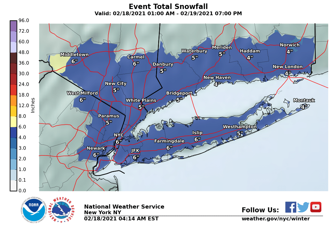
Looks like it so far, but the bands can shift. Like the NWS, RU Johnny said and many models showed, CNJ was looking to be in the bullseye - just look at the NWS snowfall graphic...You think Mercer /Middlesex/Hunterdon /Somerset gets the most snow today?
Dammit daycare closing at 12:30.
Guess kids are just staying home.
Can we stop with the Texas/South sob story?
They have had no power for like 3 days and are resorting to cannibalism. Come check out JCP&L for power resumption timelines.
It's going to be f@ucking 70° down there next week.
My sister lives in Austin with my 94 year old mom, for some reason they have not lost power the whole time. She says its like a weird miracle because everyone she knows has lost power for at least a day or more. Her block has been fine the whole time but beyond that its a mess. Austin has a fairly large homeless population, so they are dealing with that and a lot of the homes are not winter ready. If you are a plumber its going to be the place to be because the number of homes with frozen pipes is off the charts.
Similar threads
- Replies
- 62
- Views
- 2K
- Replies
- 608
- Views
- 18K
OT: Minor to Moderate (2-4?) Snowfall Likely Sat morning (2/17); will be <32F, so expect slick roads
- Replies
- 213
- Views
- 5K
- Replies
- 592
- Views
- 16K
- Replies
- 771
- Views
- 20K
ADVERTISEMENT
ADVERTISEMENT