taking my son to get vaccine shot 2... in case he doesn't feel well after...TPK was slushy but moving about 50 mph... but getting worse with heavier snow now.Why you going to elizabeth?


Colleges
- American Athletic
- Atlantic Coast
- Big 12
- Big East
- Big Ten
- Colonial
- Conference USA
- Independents (FBS)
- Junior College
- Mountain West
- Northeast
- Pac-12
- Patriot League
- Pioneer League
- Southeastern
- Sun Belt
- Army
- Charlotte
- East Carolina
- Florida Atlantic
- Memphis
- Navy
- North Texas
- Rice
- South Florida
- Temple
- Tulane
- Tulsa
- UAB
- UTSA
- Boston College
- California
- Clemson
- Duke
- Florida State
- Georgia Tech
- Louisville
- Miami (FL)
- North Carolina
- North Carolina State
- Pittsburgh
- Southern Methodist
- Stanford
- Syracuse
- Virginia
- Virginia Tech
- Wake Forest
- Arizona
- Arizona State
- Baylor
- Brigham Young
- Cincinnati
- Colorado
- Houston
- Iowa State
- Kansas
- Kansas State
- Oklahoma State
- TCU
- Texas Tech
- UCF
- Utah
- West Virginia
- Illinois
- Indiana
- Iowa
- Maryland
- Michigan
- Michigan State
- Minnesota
- Nebraska
- Northwestern
- Ohio State
- Oregon
- Penn State
- Purdue
- Rutgers
- UCLA
- USC
- Washington
- Wisconsin
High School
- Illinois HS Sports
- Indiana HS Sports
- Iowa HS Sports
- Kansas HS Sports
- Michigan HS Sports
- Minnesota HS Sports
- Missouri HS Sports
- Nebraska HS Sports
- Oklahoma HS Sports
- Texas HS Hoops
- Texas HS Sports
- Wisconsin HS Sports
- Cincinnati HS Sports
- Delaware
- Maryland HS Sports
- New Jersey HS Hoops
- New Jersey HS Sports
- NYC HS Hoops
- Ohio HS Sports
- Pennsylvania HS Sports
- Virginia HS Sports
- West Virginia HS Sports
ADVERTISEMENT
Install the app
How to install the app on iOS
Follow along with the video below to see how to install our site as a web app on your home screen.
Note: This feature may not be available in some browsers.
You are using an out of date browser. It may not display this or other websites correctly.
You should upgrade or use an alternative browser.
You should upgrade or use an alternative browser.
OT: Significant Winter Storm Likely on Thursday (2/18)
- Thread starter RU848789
- Start date

and jsut watch and hopefully enjoy the Rutgers Michigan game tonight!!It looks like the snow has finally stopped here in Little Rock. 10.8 inches Sunday/ Monday, then 11.5 inches Wednesday/ Thursday.
largest total snowfall in Arkansas recorded history. It is supposed to get above freezing on Saturday finally.
Yes, I am staying inside!
Wrong! I'm in Wayne, PA and we have more than 6 inches.Not in Philly for sure.
Yeah that’s me. I’m at work now in Dayton driving home around 3. I’d rather make a days pay then be off though. Wifey is working from home and said looks about what u said. Hopefully some stuff is plowed when I get outLooks like Mercer particular the Hamilton area is the winner thus far...6-8 inches
Got the initial thump, and it hasn't stopped yet. No mixing yet either. @Postman_1 is going to have a field day on his trip home.Looks like Mercer particular the Hamilton area is the winner thus far...6-8 inches
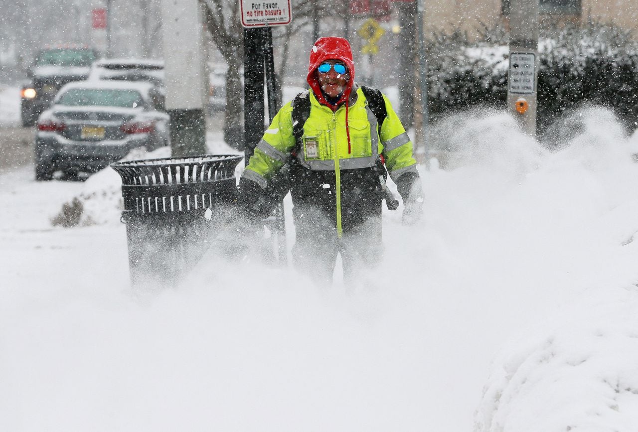
Big wave of early snow has already dumped 6 to 7 inches in some parts of state
Heavy snow bands Thursday morning caused quick accumulations in Central New Jersey.
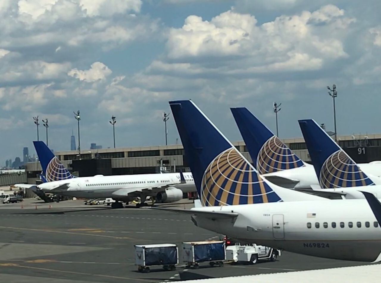
Flights canceled at airports around N.J. See delays due to mounting snowstorm.
Newark and Philadelphia airports are seeing to most flight cancelations in the region as a snow storm works it way north on Thursday morning.
Great analogy, and I completely agree.During Sandy I had no power for almost 2 weeks. It got cold that first weekend. I can relate. It really sucked. I have friends in San Antonio and Houston. They can handle the hurricanes. This cold is just a different level for them. Saying it will be 70 next week doesn't help when your house, furnace, water & electric systems were not made for this kind of cold. Then on top of that there is no snow removal equipment.
DOH! I jinxed it. Just started pouring big flakes and sleet mixed it.Got the initial thump, and it hasn't stopped yet. No mixing yet either. @Postman_1 is going to have a field day on his trip home.
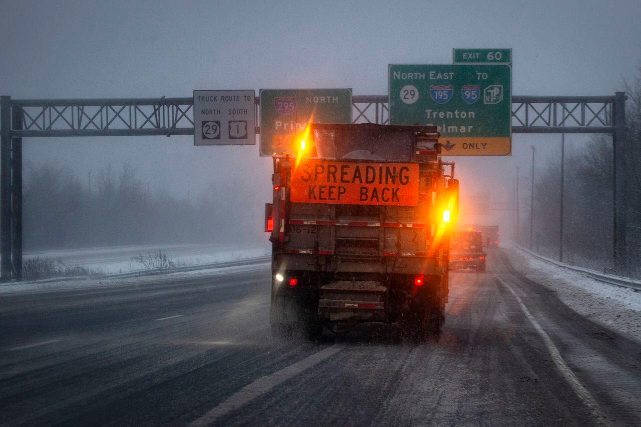
Stay off ‘treacherous’ roads, give exhausted snow crews room to plow, Gov. Murphy says
Some parts of New Jersey could see up to 8 inches of snow on Thursday from a winter that will continue into Friday.
Disagree. Immediately after Sandy the temperatures were in the 50's, so it wasn't an issue. We were without power for 6 days, fortunately for us Tyler ended up in the hospital on the 2nd day so we didn't have to worry about keeping him warm. BUT, I believe the Monday after Sandy the temperatures plummeted and we had a snowstorm. Now we got our power back right before then, but friends of mine did not, and they had issues. Some of them had to go elsewhere (relatives, etc) because it was getting dangerous. And let's not forget the fact that this area wasn't getting gasoline deliveries due to Sandy, so some people couldn't even get out because their vehicles weren't fueled.Nope, huge difference in temps, not even close.
It got a little chilly after Sandy, but not under 10 degrees.
Sandy and the aftermath did suck bigtime but it doesn't minimize what people in Texas, LA, Oklahoma, Miss, Arkansas, etc are going through with no power and brutality frigid temperatures that they are not used to.
Add in many are stuck since roads are iced up, it's a terrible situation.
I’m leaving my work van on job site that sucks in the snow and having my apprentice take me home in 4WD box truck. Should be fun ugh.DOH! I jinxed it. Just started pouring big flakes and sleet mixed it.
I'm in Fair Haven, (next to Red Bank), and I'm very surprised by the amount we've currently got on the ground. And it's still dumping here..... I like snow, but this sucks. Ha. I think we've got 5-6 inches already with no real signs of a slow down.
Its been the standard practice in the Boston area for many years.When did that silliness start? I've been seeing it for the past couple of years. What's the "reason" for it?
Radar showing heavy snow band in SE PA (yellow and red colors on radar) moving northeast toward Mercer, Hunterdon and Somerset Counties. Have to imagine red color on the radar would be 2-3 inches per hour.
All sleet under that band. If you don't like snow Hunterdon and Somerset are the places to be, will easily have the lowest totals in the storm outside of Cape May lol.
Disagree. Immediately after Sandy the temperatures were in the 50's, so it wasn't an issue. We were without power for 6 days, fortunately for us Tyler ended up in the hospital on the 2nd day so we didn't have to worry about keeping him warm. BUT, I believe the Monday after Sandy the temperatures plummeted and we had a snowstorm. Now we got our power back right before then, but friends of mine did not, and they had issues. Some of them had to go elsewhere (relatives, etc) because it was getting dangerous. And let's not forget the fact that this area wasn't getting gasoline deliveries due to Sandy, so some people couldn't even get out because their vehicles weren't fueled.
I lost power for 15 days, it sucked, I shacked over at my bro's pad for a few nights since he only lost power for 4 days, it never got that cold.

IEM :: Local Storm Report App
Iowa Environmental Mesonet of Iowa State University
Public Information Statement
National Weather Service Mount Holly NJ
1112 AM EST Thu Feb 18 2021
...SNOWFALL REPORTS...
Location Amount Time/Date Provider
...Delaware...
...Kent County...
1 SSE Woodside 0.6 in 1023 AM 02/18 Public
...New Castle County...
Hockessin 1.5 in 0940 AM 02/18 Public
New Castle County Airport 0.1 in 0700 AM 02/18 ASOS
1 ESE Woodshade 0.1 in 0712 AM 02/18 Public
...New Jersey...
...Burlington County...
Florence 5.2 in 1000 AM 02/18 Trained Spotter
1 ESE Delran 2.1 in 0710 AM 02/18 Trained Spotter
Mount Laurel 1.7 in 1005 AM 02/18 Trained Spotter
Cinnaminson 1.2 in 0814 AM 02/18 Public
1 ENE Westampton Twp 1.2 in 0930 AM 02/18 Official NWS Obs
1 WNW South Jersey Regional 1.1 in 1040 AM 02/18 NWS Employee
1 NE Marlton 0.7 in 1100 AM 02/18 Public
1 ESE Leisuretowne 0.5 in 1028 AM 02/18 Trained Spotter
...Gloucester County...
Deptford Twp 0.5 in 0650 AM 02/18 Public
West Deptford Twp 0.5 in 0908 AM 02/18 Public
West Deptford Twp 0.5 in 1041 AM 02/18 Public
2 W Pitman 0.3 in 0927 AM 02/18 Trained Spotter
...Hunterdon County...
Whitehouse Station 1.5 in 0813 AM 02/18 Public
...Mercer County...
Trenton 8.0 in 1048 AM 02/18 Public
Hamilton Twp 7.9 in 1013 AM 02/18 Public
1 SE Robbinsville Twp. 6.7 in 0933 AM 02/18 Public
2 W Yardville 6.0 in 0808 AM 02/18 Public
Robbinsville Twp. 6.0 in 0915 AM 02/18 Trained Spotter
Hightstown 4.6 in 0700 AM 02/18 CO-OP Observer
Ewing 4.5 in 1044 AM 02/18 NWS Employee
Yardville 2.9 in 0723 AM 02/18 Public
3 NW Pennington 2.8 in 1030 AM 02/18 Trained Spotter
...Middlesex County...
Cranbury 3.9 in 1000 AM 02/18 Trained Spotter
East Brunswick 3.0 in 1030 AM 02/18 Trained Spotter
...Monmouth County...
Freehold 6.5 in 0945 AM 02/18 Public
Eatontown 6.3 in 0915 AM 02/18 Public
2 N Tinton Falls 5.0 in 0839 AM 02/18 Public
1 NW Sea Bright 5.0 in 1019 AM 02/18 Public
Manalapan Township 4.3 in 0904 AM 02/18 Trained Spotter
Freehold Twp 3.4 in 0913 AM 02/18 Trained Spotter
Strathmore 2.0 in 0900 AM 02/18 Trained Spotter
Howell 1.8 in 0830 AM 02/18 Public
...Morris County...
Lake Hopatcong 1.4 in 1043 AM 02/18 Trained Spotter
...Ocean County...
Jackson 2.8 in 0900 AM 02/18 NWS Employee
Brick 1.5 in 0927 AM 02/18 Public
Jackson 1.0 in 0915 AM 02/18 Public
...Somerset County...
Branchburg Twp 1.0 in 0826 AM 02/18 Public
...Warren County...
Blairstown 1.5 in 1044 AM 02/18 Cocorahs
...Pennsylvania...
...Berks County...
Spring Twp 4.0 in 1037 AM 02/18 Public
Morgantown 3.0 in 1000 AM 02/18 Public
1 ENE Hamburg 2.0 in 1019 AM 02/18 Public
1 N Union Twp 1.0 in 0825 AM 02/18 Public
...Bucks County...
Feasterville-Trevose 8.0 in 0949 AM 02/18 Public
1 NNW Eddington 7.0 in 1000 AM 02/18 Public
Langhorne 6.7 in 0915 AM 02/18 Public
Morrisville 6.5 in 0830 AM 02/18 Trained Spotter
Lower Makefield Twp 6.5 in 1000 AM 02/18 Public
1 W Levittown 6.0 in 0809 AM 02/18 Public
Fairless Hills 6.0 in 1046 AM 02/18 Public
Newtown 5.5 in 0848 AM 02/18 Public
Bensalem 5.5 in 0914 AM 02/18 Trained Spotter
Warminster 5.0 in 0939 AM 02/18 Trained Spotter
Richboro 4.5 in 0906 AM 02/18 Public
2 ESE Newtown 3.5 in 0700 AM 02/18 Cocorahs
Newtown Grant 3.1 in 1059 AM 02/18 Public
West Rockhill Twp 2.5 in 0942 AM 02/18 Public
Sellersville 2.5 in 0952 AM 02/18 Trained Spotter
Bristol 2.3 in 0849 AM 02/18 Public
Quakertown 2.3 in 1000 AM 02/18 Trained Spotter
Trumbauersville 2.2 in 1107 AM 02/18 Trained Spotter
Trumbauersville 1.2 in 0915 AM 02/18 Trained Spotter
New Hope 0.3 in 0640 AM 02/18 Trained Spotter
...Carbon County...
2 S Meckesville 0.5 in 0941 AM 02/18 Trained Spotter
...Chester County...
Malvern 9.0 in 0950 AM 02/18 Public
2 N East Goshen Twp. 8.0 in 0944 AM 02/18 Public
West Goshen 8.0 in 1000 AM 02/18 Public
East Fallowfield Twp 7.8 in 0942 AM 02/18 Public
Downington 7.8 in 1016 AM 02/18 Public
Paoli 7.5 in 0900 AM 02/18 Trained Spotter
East Brandywine Twp 7.5 in 0948 AM 02/18 Public
Parkesburg 7.3 in 1017 AM 02/18 Public
Berwyn 7.0 in 0800 AM 02/18 Public
Exton 7.0 in 0900 AM 02/18 Trained Spotter
1 WNW Uwchlan Twp 7.0 in 1030 AM 02/18 Public
Uwchlan Twp 6.0 in 0950 AM 02/18 Trained Spotter
Phoenixville 5.6 in 1000 AM 02/18 Public
East Nantmeal Twp 5.5 in 1004 AM 02/18 Trained Spotter
Schuylkill Twp 4.5 in 0900 AM 02/18 Public
West Caln Twp 4.5 in 0900 AM 02/18 Trained Spotter
Coatesville 4.0 in 0608 AM 02/18 Public
Pughtown 4.0 in 0904 AM 02/18 Public
East Coventry Twp 4.0 in 1000 AM 02/18 Trained Spotter
2 S Wallace Twp 3.5 in 0900 AM 02/18 Trained Spotter
Spring City 3.0 in 0905 AM 02/18 Public
Jennersville 2.6 in 0945 AM 02/18 Public
Modena 2.5 in 0533 AM 02/18 Public
New London Twp. 2.2 in 1003 AM 02/18 Public
West Chester 2.1 in 1000 AM 02/18 Trained Spotter
Oxford 1.5 in 0800 AM 02/18 Trained Spotter
Lincoln University 1.1 in 0830 AM 02/18 Public
...Delaware County...
Wayne 8.7 in 0925 AM 02/18 Trained Spotter
Clifton Heights 3.0 in 0700 AM 02/18 Public
Brookhaven 3.0 in 1026 AM 02/18 Public
1 NE Lawrence Park 2.5 in 0930 AM 02/18 Public
Thornton 2.1 in 1000 AM 02/18 Trained Spotter
1 E Upper Chichester Twp 2.0 in 1031 AM 02/18 Public
Upper Darby 1.5 in 0819 AM 02/18 Public
Chadds Ford Twp 1.3 in 0847 AM 02/18 Trained Spotter
Upper Chichester Twp 0.6 in 0640 AM 02/18 Trained Spotter
Folsom 0.5 in 0659 AM 02/18 Public
...Lehigh County...
Macungie 3.0 in 1025 AM 02/18 Trained Spotter
2 ESE Lehigh Valley Internat 3.0 in 1050 AM 02/18 Trained Spotter
Breinigsville 2.8 in 1020 AM 02/18 Public
New Tripoli 1.5 in 0900 AM 02/18 Trained Spotter
Lehigh Valley International 0.2 in 0700 AM 02/18 ASOS
...Montgomery County...
King of Prussia 8.5 in 1012 AM 02/18 Trained Spotter
Norristown 8.1 in 0949 AM 02/18 Public
Whitemarsh Twp 8.0 in 0940 AM 02/18 Public
Abington 7.8 in 0917 AM 02/18 Public
Glenside 7.3 in 0941 AM 02/18 Public
2 WNW Lower Moreland Twp 7.0 in 0920 AM 02/18 Public
Valley Forge 7.0 in 1040 AM 02/18 Trained Spotter
Conshohocken 6.0 in 0858 AM 02/18 Public
Hatboro 5.0 in 0848 AM 02/18 Public
1 W Ambler 5.0 in 0907 AM 02/18 Trained Spotter
Plymouth Meeting 4.3 in 0830 AM 02/18 Trained Spotter
Jenkintown 4.0 in 0814 AM 02/18 Public
Blue Bell 4.0 in 0832 AM 02/18 Public
Skippack Twp 3.5 in 1041 AM 02/18 Trained Spotter
New Hanover Twp 3.3 in 1100 AM 02/18 Public
Bala Cynwyd 3.2 in 1000 AM 02/18 Public
Lansdale 3.0 in 0945 AM 02/18 Trained Spotter
Spring Mount 2.8 in 0930 AM 02/18 Public
Eagleville 2.0 in 0730 AM 02/18 Trained Spotter
Ambler 0.3 in 0800 AM 02/18 CO-OP Observer
...Northampton County...
Nazareth 2.8 in 1035 AM 02/18 Public
Martins Creek 1.4 in 0930 AM 02/18 Trained Spotter
...Philadelphia County...
Mount Airy 5.5 in 0930 AM 02/18 Public
Northeast Philadelphia 4.0 in 0823 AM 02/18 Public
Manayunk 2.5 in 0815 AM 02/18 Trained Spotter
1 SE Point Breeze 2.3 in 1059 AM 02/18 Trained Spotter
Fox Chase 2.2 in 0905 AM 02/18 Trained Spotter
Philadelphia 2.0 in 0951 AM 02/18 Public
Philadelphia International A 0.6 in 0700 AM 02/18 ASOS
...FREEZING RAIN REPORTS...
Location Amount Time/Date Provider
...Delaware...
...New Castle County...
New Castle County Airport 0.07 in 0951 AM 02/18 ASOS
...Sussex County...
Delaware Coastal Airport 0.20 in 0954 AM 02/18 ASOS
2 NNE Harbeson 0.10 in 0947 AM 02/18 CO-OP Observer
...New Jersey...
...Atlantic County...
1 NW Atlantic City Internati 0.05 in 0854 AM 02/18 ASOS
...Cumberland County...
Millville Municipal Airport 0.08 in 0954 AM 02/18 ASOS
...Gloucester County...
Williamstown 0.05 in 0930 AM 02/18 Trained Spotter
&&
On and off whiteouts in Newark. Roads were fine earlier in the morning...not looking too great now.
I so should have went skiing. Had a mortgage thing, but they cancelled.Radar showing heavy snow band in SE PA (yellow and red colors on radar) moving northeast toward Mercer, Hunterdon and Somerset Counties. Have to imagine red color on the radar would be 2-3 inches per hour.
Here in the Bayshore it is dumping pretty good. Maybe signs of transitioning to sleet. Sleet like snow at least.
yep gone to sleet here, got 3, 3 and quarter inches of snow and looks like its sleet before it ends, then we see if we get the 2nd punch
RU Johnny what does it look like for end times today. 2-3 PM for central jersey?..
RU Johnny what does it look like for end times today. 2-3 PM for central jersey?..
Back edge moving into eastern PA. Should be wrapping up the first phase of this one by 3pm.
beat me to it
Back edge moving into eastern PA. Should be wrapping up the first phase of this one by 3pm.
so IF we get a 2nd punch whats the timing on that?
As of 10:00 am it's pouring heavy snow here with 2.3" OTG at 24F.
Heading to Elizabeth for about 90 minutes...
Just drove back from Elizabeth to Metuchen with my son, after stopping for White Castle of course and it was snow until about Woodbridge, when I heard pinging on the windshield and I thought, no damn this can't be sleet already as the met on 1010 WINS said the sleet line was in Manasquan. Sounds like it was more like rimed snow (with supercooled liquid that crystallizes as ice on snowflakes, making them kind of large and hard) - didn't see the classic small discrete perfectly formed sleet pellets (usually somewhat cubic) that were clear ice and they definitely made noise like sleet - have only seen that a few times. From what I heard we had a fair amount of that rimed snow, but also sleet while I was gone.
Had 2.25" at 10 am and now have 3.5" at noon, which is only 1.25" in the last 2 hours - if that had been all snow, it would have been 2-3"+, looking at the radar intensity. Oh well, still a cool storm with more to go. Currently a mix of sleet and snow.
Similar threads
- Replies
- 62
- Views
- 2K
- Replies
- 608
- Views
- 18K
OT: Minor to Moderate (2-4?) Snowfall Likely Sat morning (2/17); will be <32F, so expect slick roads
- Replies
- 213
- Views
- 5K
- Replies
- 592
- Views
- 16K
- Replies
- 771
- Views
- 20K
ADVERTISEMENT
ADVERTISEMENT