because T2K is being his usual ornery self and trying to troll RU#'s.I don’t know why some think this storm was a bust. It’s still snowing in Tinton Falls, although at a slower rate. We have easily 8”, much more than the 4-5” we were forecast to get.


Colleges
- AAC
- ACC
- Big 12
- Big East
- Big Ten
- Pac-12
- SEC
- Atlantic 10
- Conference USA
- Independents
- Junior College
- Mountain West
- Sun Belt
- MAC
- More
- Navy
- UAB
- Tulsa
- UTSA
- Charlotte
- Florida Atlantic
- Temple
- Rice
- East Carolina
- USF
- SMU
- North Texas
- Tulane
- Memphis
- Miami
- Louisville
- Virginia
- Syracuse
- Wake Forest
- Duke
- Boston College
- Virginia Tech
- Georgia Tech
- Pittsburgh
- North Carolina
- North Carolina State
- Clemson
- Florida State
- Cincinnati
- BYU
- Houston
- Iowa State
- Kansas State
- Kansas
- Texas
- Oklahoma State
- TCU
- Texas Tech
- Baylor
- Oklahoma
- UCF
- West Virginia
- Wisconsin
- Penn State
- Ohio State
- Purdue
- Minnesota
- Iowa
- Nebraska
- Illinois
- Indiana
- Rutgers
- Michigan State
- Maryland
- Michigan
- Northwestern
- Arizona State
- Oregon State
- UCLA
- Colorado
- Stanford
- Oregon
- Arizona
- California
- Washington
- USC
- Utah
- Washington State
- Texas A&M
- Auburn
- Mississippi State
- Kentucky
- South Carolina
- Arkansas
- Florida
- Missouri
- Ole Miss
- Alabama
- LSU
- Georgia
- Vanderbilt
- Tennessee
- Louisiana Tech
- New Mexico State
- Middle Tennessee
- Western Kentucky
- UTEP
- Florida International University
High School
- West
- Midwest
- Northeast
- Southeast
- Other
- Alaska
- Arizona
- California
- Colorado
- Nevada
- New Mexico
- Northern California
- Oregon
- Southern California Preps
- Washington
- Edgy Tim
- Indiana
- Kansas
- Nebraska
- Iowa
- Michigan
- Minnesota
- Missouri
- Oklahoma Varsity
- Texas Basketball
- Texas
- Wisconsin
- Delaware
- Maryland
- New Jersey Basketball
- New Jersey
- New York City Basketball
- Ohio
- Pennsylvania
- Greater Cincinnati
- Virginia
- West Virginia Preps
ADVERTISEMENT
Install the app
How to install the app on iOS
Follow along with the video below to see how to install our site as a web app on your home screen.
Note: This feature may not be available in some browsers.
You are using an out of date browser. It may not display this or other websites correctly.
You should upgrade or use an alternative browser.
You should upgrade or use an alternative browser.
OT: Significant Winter Storm Likely on Thursday (2/18)
- Thread starter RU848789
- Start date

In Texarkana,Arkansas let the Texas half of a shared road go unplowed.The picture is in The NY Post.
There's a shared road in Raritan/Bridgewater where the same thing happens. Raritan side is almost always down to pavement, Bridgewater side is almost always a disaster.
Awesome. I'm due for an upgrade. Next year1st punch was just enough thanks!! Closed store early... got home and pulled out new 34" "Beast" that basically laughed at this snow!!! (Bought the new snowblower 10 days ago... and even that didnt stop this storm!!) But DAMNNNNNNN... It laughed at that heavy slush at the bottom of the driveway!!
And he does it very well, given how RU#'s just can't resist replying to him.because T2K is being his usual ornery self and trying to troll RU#'s.
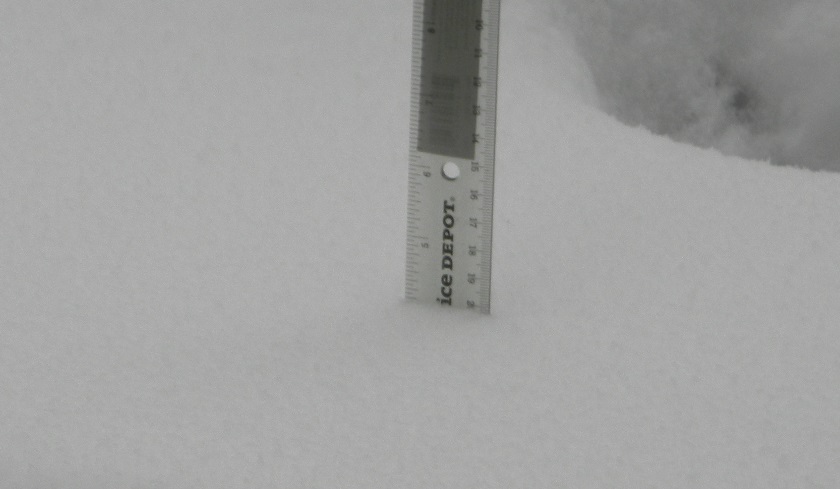
So we topped out at 4 1/8 inches:
In that case, I would have been okay with 5 inches of snow today! Probably 3.5 in No. Plfd.Nice when recent commits have as many stars as latest inches of snow
Yup and for the longest time on Rock Avenue from North Plainfield heading into Plainfield. There seemed be a disagreement or misunderstanding of where each county’s responsibility began and ended. There was a stretch that was always a mess. Short stretch though.There's a shared road in Raritan/Bridgewater where the same thing happens. Raritan side is almost always down to pavement, Bridgewater side is almost always a disaster.
And a few lower. NWS still can't get Philly right.Same as the NWS, basically - 4-7" - almost everyone was in that range, with a few higher...
NWS:
The main show of this winter storm has exited the region, however periods of light wintry mix are expected to persist through Friday morning. Additional light snow accumulations of 1-3" and/or a glaze of ice are possible mainly inland, but also coastal areas north of AC. Use caution if you must travel through especially Friday morning as snowmelt may refreeze on roadways. A Winter Weather Advisory remains in effect for the entire area through Friday afternoon except for the coastal strip from Atlantic City and southward.

 fb.watch
The main show of this winter storm has exited the region, however periods of light wintry mix are expected to persist through Friday morning. Additional light snow accumulations of 1-3" and/or a glaze of ice are possible mainly inland, but also coastal areas north of AC. Use caution if you must travel through especially Friday morning as snowmelt may refreeze on roadways. A Winter Weather Advisory remains in effect for the entire area through Friday afternoon except for the coastal strip from Atlantic City and southward.
US National Weather Service Philadelphia/Mount Holly - Mid-February Winter Storm Lingering through Friday | Facebook | By US National Weather Service Philadelphia/Mount Holly | ❄️🧊 The main show of this winter storm has exited the region, however per
13K views, 93 likes, 1 loves, 5 comments, 66 shares, Facebook Watch Videos from US National Weather Service Philadelphia/Mount Holly: ❄️🧊 The main show of this winter storm has exited the region,...
fb.watch
In Texarkana,Arkansas let the Texas half of a shared road go unplowed.The picture is in The NY Post.
Arkansas is NOT responsible for the texass side.
I just looked at a map of the Memphis area and saw that there's a dog track in West Memphis across the river in Arkansas.After Florida banned dog racing,I figured that they were finished in the South.Arkansas is NOT responsible for the texass side.
Awesome. I'm due for an upgrade. Next year
well worth it!! "The Beast" is laughing at this storm!!
+1And he does it very well, given how RU#'s just can't resist replying to him.
So we topped out at 4 1/8 inches:
You would think that he would have figured out how to control himself by now! 😁
Hard to tell with the wind blowing it around. I'm guessing 3", 4" max in Manasquan which beats the other storms this season.
I just looked at a map of the Memphis area and saw that there's a dog track in West Memphis across the river in Arkansas.After Florida banned dog racing,I figured that they were finished in the South.
I’ve been there (a long time ago) .... and compared to the crowd, I never felt better about myself in my life
I'd actually call it the 276/195 storm...I think this storm was the 195 storm. Seems like that’s where the big band dropped its load.

Depends where you are in Philly...And a few lower. NWS still can't get Philly right.
...Philadelphia County...
Chestnut Hill 8.8 in 1259 PM 02/18 Public
Mount Airy 5.5 in 0930 AM 02/18 Public
Northeast Philadelphia 5.5 in 1140 AM 02/18 Public
Philadelphia 3.1 in 0142 PM 02/18 Public
1 ESE Kensington 2.8 in 1212 PM 02/18 Public
Philadelphia Internati 2.8 in 0700 PM 02/18 ASOS
1 SE Point Breeze 2.3 in 1059 AM 02/18 Trained Spotter
And he does it very well, given how RU#'s just can't resist replying to him.
So we topped out at 4 1/8 inches:
Yeah, not really. He gets mocked and destroyed and looks like a fool. Over and over again.
He's won by getting the lengthy response. Doesn't matter if it's right, wrong, or whatever response comes. He got under #'s skin. Goal achieved.Yeah, not really. He gets mocked and destroyed and looks like a fool. Over and over again.
Only one neighborhood beat 6 inches. Center City area way below, again. Amazing all storms never came near NWS number in the CC area. I'm between Pt Breeze and the Airport. Maybe a mile tops from Pt. Breeze. Around 7am the locals all reduced the forecast amounts but as I've always said once the storm starts its not a forecast but an observation. Again the Delaware River areas of Philly all underperformed again.Depends where you are in Philly...
...Philadelphia County...
Chestnut Hill 8.8 in 1259 PM 02/18 Public
Mount Airy 5.5 in 0930 AM 02/18 Public
Northeast Philadelphia 5.5 in 1140 AM 02/18 Public
Philadelphia 3.1 in 0142 PM 02/18 Public
1 ESE Kensington 2.8 in 1212 PM 02/18 Public
Philadelphia Internati 2.8 in 0700 PM 02/18 ASOS
1 SE Point Breeze 2.3 in 1059 AM 02/18 Trained Spotter
Chestnut Hill is very close to Conshohocken both about 10 miles outside of Center City.
Yes, people need to be careful out there. I just woke up from a nap and missed the freezing rain (ZR). We have a decent glaze (guessing 0.05-0.10") on everything and it's slippery on any untreated surface. Luckily I had put salt down where I had shoveled. The advisory does say for 1-3" and up to 0.10" of freezing rain. It also mentions the freezing rain for every other group of counties under the NWS in Philly and NYC.Joy, now it is a bit of freezing drizzle. I just almost killed myself on my steep driveway trying to get the mail(of course it hadn't come yet).
URGENT - WINTER WEATHER MESSAGE
National Weather Service Mount Holly NJ
352 PM EST Thu Feb 18 2021
New Castle-Hunterdon-Somerset-Middlesex-Western Monmouth-
Eastern Monmouth-Mercer-Salem-Gloucester-Camden-
Northwestern Burlington-Delaware-Philadelphia-Eastern Montgomery-
Upper Bucks-Lower Bucks-
352 PM EST Thu Feb 18 2021
...WINTER WEATHER ADVISORY IN EFFECT UNTIL 7 PM EST FRIDAY...
...WINTER STORM WARNING IS CANCELLED...
* WHAT...Mixed precipitation. Additional snow accumulations of 1
to 3 inches and ice accumulations of around one tenth of an
inch.
* WHERE...Portions of central, northern, northwest and southern
New Jersey, southeast Pennsylvania and northern Delaware.
* WHEN...Until 7 PM EST Friday.
* IMPACTS...Expect slippery road conditions. The hazardous
conditions will impact the commute times this evening and on
Friday morning.
* ADDITIONAL DETAILS...Patchy freezing drizzle, sleet, and snow
will continue through the evening hours. Snow, sleet, and rain
will then increase Friday around sunrise from the southwest as
the next system approaches.
He's won by getting the lengthy response. Doesn't matter if it's right, wrong, or whatever response comes. He got under #'s skin. Goal achieved.
Nah, not when he's repeatedly made to look like a total fool. Which happens multiple times in every one of these threads.
And #s still wins by virtue of the fact that he posts a weather thread and the troll brigade, which now apparently includes a "mod," trips over itself to see who makes the dumbest response. Every time. Death, taxes, weather trolls.
T2K is always the first to run and report to mods, too, so it's not like he's a cool, collected guy.
Disagree somewhat - yes he's annoying, but I also only respond selectively these days and I'm certain he comes out looking far worse. Who wants to be known as a troll?He's won by getting the lengthy response. Doesn't matter if it's right, wrong, or whatever response comes. He got under #'s skin. Goal achieved.
Definitely underperformed for the SE parts of the city, although I'm certain that's due to sleet cutting down on depth, but not frozen mass. Yes the number said 6", but the swath was 4-6" and the warning was for 4-7" and much of the city was in the 4-7" range. Can you actually imagine making a forecast saying SE Philly will get 2" of snow and 1" of sleet (3" of depth, but 5" of snow equivalent), while NE/NW Philly will get 5-7"? Nobody is that good. Nobody. So they forecast 4-7" and hope everyone is in the range and they were on mass, but not on depth. For me that's still a good forecast, but I know it's not for you and we'll simply never agree on that, which is OK.Only one neighborhood beat 6 inches. Center City area way below, again. Amazing all storms never came near NWS number in the CC area. I'm between Pt Breeze and the Airport. Maybe a mile tops from Pt. Breeze. Around 7am the locals all reduced the forecast amounts but as I've always said once the storm starts its not a forecast but an observation. Again the Delaware River areas of Philly all underperformed again.
Chestnut Hill is very close to Conshohocken both about 10 miles outside of Center City.
I just looked at a map of the Memphis area and saw that there's a dog track in West Memphis across the river in Arkansas.After Florida banned dog racing,I figured that they were finished in the South.
Southland Greyhound racing track has stopped Greyhound racing but operate a casino name Southland. It is a fairly big draw as Memphis, Tn is only 5 miles away.
One has to consider that there may be exceptions to certain rules. Some of them involve common sense, such as not staring at the sun during an eclipse--or other times for that matter. 😎😎
Reminds me of the meme "Don't look into laser with remaining eye."
He nailed it. This is like grade school, where if someone is needling you, by responding you're validating them.He's won by getting the lengthy response. Doesn't matter if it's right, wrong, or whatever response comes. He got under #'s skin. Goal achieved.Yeah, not really. He gets mocked and destroyed and looks like a fool. Over and over again.
We didn't get much sleet here. Maybe 30 mins of very light stuff that you had to see bouncing off something. Yes the number said 6. And again they missed it for the most populated area of Philly even at 4-6. Believe it or not the Airport number is Philadelphia's official number for record. Which is odd. They should have used behind Independence Hall when they started keeping weather records. And I get your mass versus depth argument but doesn't apply today. For 2 reasons. We didn't get that much sleet. They gave a forecast which included the crossover. The Point Breeze number at the time stated is very close to the time of the switch. I don't like the Airport number for several reason. Its not in the city, its not in a concrete jungle, it not in between two major rivers. I dont like it more for the official temperature, especially in the summer than snowfall. I can't say the NWS failures in CC is a bust anymore. Its a lack of looking at the last 10 years of them ignoring the data of their failures in CC. I still think its the river temps affect. It never comes close to freezing anymore. Something that was common many years ago. |
How about grown men don’t behave as if this was grade school in the first place?He nailed it. This is like grade school, where if someone is needling you, by responding you're validating them.
He nailed it. This is like grade school, where if someone is needling you, by responding you're validating them.
I agree.
You guys are grade school-level.
BTW what was the Wilmington DE number today? They always get lumped in with CC Philly and always underperformedDefinitely underperformed for the SE parts of the city, although I'm certain that's due to sleet cutting down on depth, but not frozen mass. Yes the number said 6", but the swath was 4-6" and the warning was for 4-7" and much of the city was in the 4-7" range. Can you actually imagine making a forecast saying SE Philly will get 2" of snow and 1" of sleet (3" of depth, but 5" of snow equivalent), while NE/NW Philly will get 5-7"? Nobody is that good. Nobody. So they forecast 4-7" and hope everyone is in the range and they were on mass, but not on depth. For me that's still a good forecast, but I know it's not for you and we'll simply never agree on that, which is OK.
I am rubber, you are glue. Whatever you say bounces off of me and sticks to you.I agree.
You guys are grade school-level.
Disagree somewhat - yes he's annoying, but I also only respond selectively these days and I'm certain he comes out looking far worse. Who wants to be known as a troll?
Really, MANY on this board consider ###s is performing a service by posting his weather threads. Yes, we acknowledge that he loves snow & may lean towards being optimistic when predicting snow totals, but even that has been tempered recently & he not only posts model predictions but updates them as they change,even if it means lowering snow predictions. To have a tool like T2k come in adds nothing of a positive nature to the threads. Personally, I think ###s has been very generous by not ripping in to him even more. Wish he would take a long vacation ,at least from weather threads.
The funny thing about that line it is grade school level. It will go right over his head because he is just kindergarten level. Maybe next year he'll get it.I am rubber, you are glue. Whatever you say bounces off of me and sticks to you.
Similar threads
- Replies
- 62
- Views
- 2K
- Replies
- 608
- Views
- 17K
OT: Minor to Moderate (2-4?) Snowfall Likely Sat morning (2/17); will be <32F, so expect slick roads
- Replies
- 213
- Views
- 5K
- Replies
- 592
- Views
- 15K
- Replies
- 771
- Views
- 20K
ADVERTISEMENT
Latest posts
-
-
-
With the portal now open, does Gavin Wimsatt enter after the spring game?
- Latest: Nycrusupporter
ADVERTISEMENT