ADVERTISEMENT

OT: Tropical Storm Ophelia? Possibly, but definitely lots of rain and wind for our area Sat/Sun

RU848789

Legend
Gold Member
Jul 27, 2001
60,561
39,142
113
Metuchen, NJ
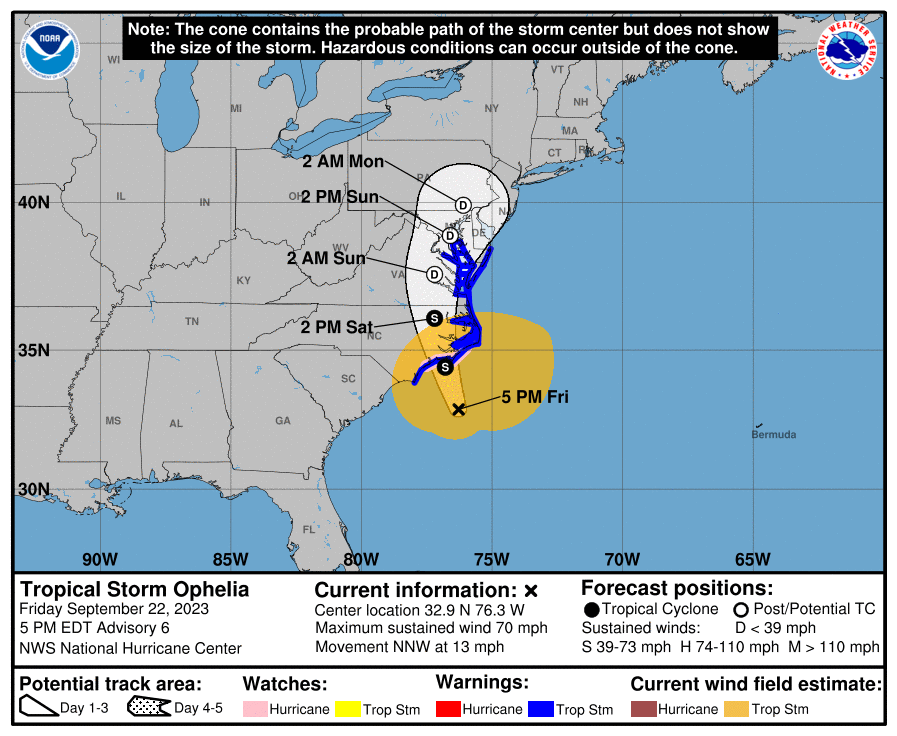
Short note, as I'm on vacation down in FL (dad's 90th!), but the NHC has dubbed the low pressure system off the coast of northern Florida as a potential tropical cyclone, as it is expected to transition from a cold core non-tropical system (name would be Ophelia) to a warm core tropical storm today before making landfall tonight on the Outer Banks of NC. The storm already has ~50 mph winds and is expected to strengthen to 60 mph before landfall.

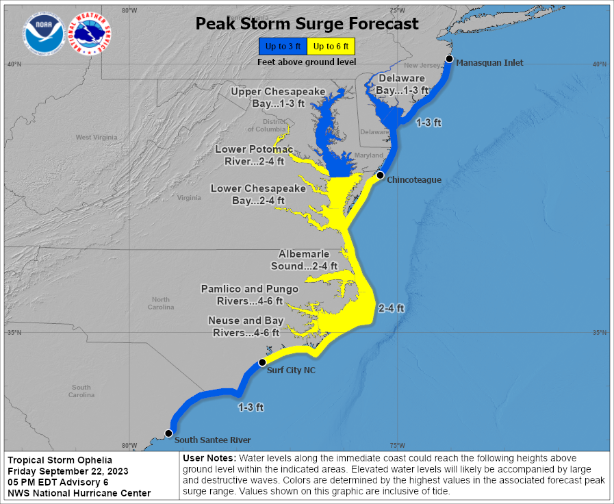
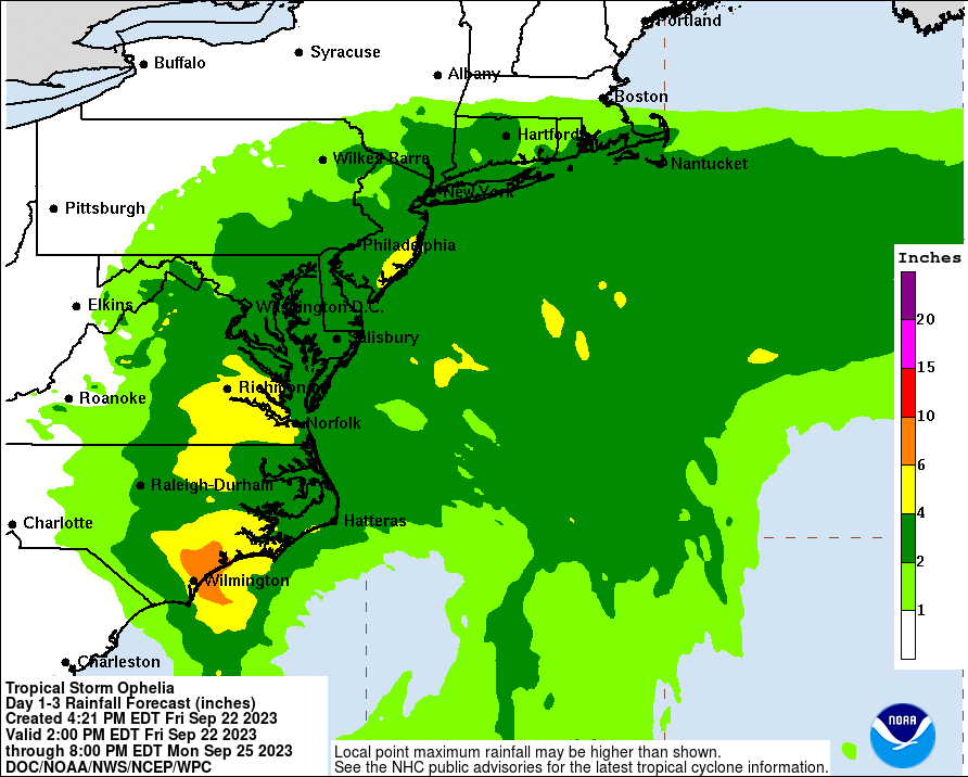
The storm/remnants will then curve through VA and the DelMarVa, bringing 30-50 mph winds to the DE/NJ coasts (high wind warnings are up for Ocean County through DE beaches and a wind advisory is up for Monmouth County) on Saturday into Sunday, along with 2-4" of rain for much of the area, especially towards the coast. Some moderate coastal flooding is also likely (and even locally major) with advisories up.

https://www.nhc.noaa.gov/text/refresh/MIATCDAT1+shtml/220834.shtml?

https://www.weather.gov/phi/
 
Any chance of this developing beyond tropical storm strength?
Close to zero, since it's going to make landfall very early tomorrow in NC, so it won't have much time to strengthen, plus none of the models show it getting stronger than 60 mph. Whether or not it becomes "tropical" really won't change the forecast any, as it's a storm and it's going to bring rain, wind and some surge/flooding from SC to NJ and heavy rains into New England.

FORECAST POSITIONS AND MAX WINDS

INIT 22/0900Z 30.5N 75.0W 45 KT 50 MPH...POTENTIAL TROP CYCLONE
12H 22/1800Z 31.6N 75.8W 50 KT 60 MPH...TROPICAL CYCLONE
24H 23/0600Z 33.4N 76.5W 50 KT 60 MPH
36H 23/1800Z 35.3N 76.8W 45 KT 50 MPH...INLAND
48H 24/0600Z 37.0N 76.9W 35 KT 40 MPH...INLAND
60H 24/1800Z 38.3N 76.3W 30 KT 35 MPH...POST-TROP/EXTRATROP
72H 25/0600Z 39.0N 75.2W 30 KT 35 MPH...POST-TROP/EXTRATROP
96H 26/0600Z...DISSIPATED

115304_5day_cone_with_line_and_wind.png
 
  • Like
Reactions: rurichdog
?? Track slowed down that much ??

Early yesterday evening weather channel had it up in Boston area Sunday night
 
?? Track slowed down that much ??

Early yesterday evening weather channel had it up in Boston area Sunday night
Didn't see TWC yesterday, but it's always been forecast to be in our area by Monday morning, but that's just the center of circulation. Since this started out as a non-tropical low and still has some of those nor'easter style characteristics, the impacts are going to be felt in NJ starting early Saturday even though the storm will be making landfall in NC then (in most nor'easters, the heaviest precip up here is often when the storms are off the NC/VA coast), with New England getting hit starting later on Saturday. Maybe TWC was talking impacts, not where the storm center would be, as they always use the NHC tracks.
 
FORECAST POSITIONS AND MAX WINDS

INIT 22/0900Z 30.5N 75.0W 45 KT 50 MPH...POTENTIAL TROP CYCLONE
12H 22/1800Z 31.6N 75.8W 50 KT 60 MPH...TROPICAL CYCLONE
24H 23/0600Z 33.4N 76.5W 50 KT 60 MPH
36H 23/1800Z 35.3N 76.8W 45 KT 50 MPH...INLAND
48H 24/0600Z 37.0N 76.9W 35 KT 40 MPH...INLAND
60H 24/1800Z 38.3N 76.3W 30 KT 35 MPH...POST-TROP/EXTRATROP
72H 25/0600Z 39.0N 75.2W 30 KT 35 MPH...POST-TROP/EXTRATROP
96H 26/0600Z...DISSIPATED
So the expectation is that by Tuesday, the storm will be rain and winds under 35 mph, yes? And centered up around Rhode Island or thereabouts?
 
It's not even trolling at a high level. Simply living off past accomplishments.
True. It is very weak, lacks any creativity or humor or effort, and thus reflects poorly on him. And when he's joined by the rest of the middle-school clique, it becomes sad and embarrassing for them all.

But it's a free country and people are free to humiliate themselves as they wish. Heck, some people pay for it.

I would pay for it, but sheep humiliate me for free. Mildone, you're baaaaaad, they say. Very, very baaaaaaad.
 
That's not how the internet works. :)

no. thats exactly how the internet works.

I dont care what is on 99.99999999999999% of the internet so I ignore the 99.99999999999999% of stuff I dont care about. THAT is how it works.

for example, I dont care about scrapbooking. therefore, I dont go on a scrapbook facebook page or message board and tell them that no one cares about scrapbooking. If I did that I would just be an annoying internet troll.

just like you are being right now.
 
Thank God t's an away game, but after 3 home games I really needed the weekend to finish up aerating, fertilizing and seeding my fields. Trying to compress everything into a half day Thursday(real work till 2pm/then farm till 7pm) and Friday just isn't going to work. I'll be seeding after work for the next week.
 
Thank God t's an away game, but after 3 home games I really needed the weekend to finish up aerating, fertilizing and seeding my fields. Trying to compress everything into a half day Thursday(real work till 2pm/then farm till 7pm) and Friday just isn't going to work. I'll be seeding after work for the next week.
I hope to spend some of my weekend seeding and fertilizing, too.
 
Hearing 2+ inches of rain and gusts up to 50mph along coastal Monmouth?
 
Just to get ahead of this one, this is a pretty complex setup that comes in two waves. There is a high bust potential here in both directions. Some modeling suggests some rather significant frontogenesis setting up over NYC metro and CNJ, dumping 2-4 regionwide. There is also the chance this gets suppressed a bit by a strong blocking HP, keeping the heaviest totals south and east of NJ. In this scenario 0.5-1.5 would be expected regionwide.

Winds are a tough one as well, the stronger the HP, the stronger the pressure gradient. That is what will drive winds around here moreso than any of the subtropical remnants moving through. Wouldn't be surprised to see gusts in 30-40 MPH range inland and 50-60 on the immediate coastline.

And, to add some fun to the forecast, some clown model runs have shown the thing doing a slow meandering loop off the coast and coming back for round 2 next week.
Accuweather cut the amounts for Saturday's Sunday for northeast NJ
Hoping they see it being pushed more off shore
 
Ophelia was just born as a tropical storm at 5 pm and has unexpectedly already strengthened to 70 mph winds and is expected to make landfall around 2-4 am Saturday somewhere between Morehead City and Okracoke NC, perhaps as a 75 mph hurricane (although the storm is not forecast to go above 70 mph). Obviously, this will likely lead to increased surge/coastal flooding from Chincoteague, Va south through NC with 2-4' (and locally up to 6') of surge possible.

Some moderate coastal flooding (1-3') is also looking likely for the DE/NJ coast on Saturday, while winds along the NJ coast could gust to 50-60 mph (and up to 30-40 mph even inland), and we're likely to see 2-4" of rain SE of 95 (especially near the coast) and maybe 1-2" NW of 95, overall (Sat into Sunday). Probably not enough rain for significant stream flooding (as the rains are falling over 18-24 hours, not all at once like summertime t-storms), but localized urban flooding is possible.

https://www.nhc.noaa.gov/graphics_at1.shtml?start#contents

FORECAST POSITIONS AND MAX WINDS

INIT 22/2100Z 32.9N 76.3W 60 KT 70 MPH
12H 23/0600Z 34.4N 76.8W 60 KT 70 MPH
24H 23/1800Z 36.1N 77.2W 45 KT 50 MPH...INLAND
36H 24/0600Z 37.6N 77.2W 30 KT 35 MPH...POST-TROP/EXTRATROP
48H 24/1800Z 38.9N 76.6W 25 KT 30 MPH...POST-TROP/EXTRATROP
60H 25/0600Z 39.9N 76.1W 25 KT 30 MPH...POST-TROP/EXTRATROP
72H 25/1800Z...DISSIPATED

bLCBLZb.png


Q6zdwqj.png


TS8jWL2.png
 
  • Like
Reactions: phs73rc77gsm83
Ocean sure is angry today.
Can you blame it?

Imagine you're just chilling out, enjoying the passing centuries as you mind your own business, focused 24/7 on providing free housing for countless species of plants and animals.

Then along comes man who proceeds to spend his entire existence dumping sewage, oil, toxic waste, and all manner of other detritus on you for decades, often killing plants and animals you've housed so lovingly for so many centuries.

See if you don't start to get a wee bit angry yourself. 🙂
Beats what it faced in the Ice Age.
 
Well, that's why @rurichdog and I (and any met worth his/her salt) used just enough weasel words, lol - storm's now up to 70 mph and it wouldn't take much more strengthening to get to 75 mph in the next ~8 hours before landfall...
I'll take an 'L'. When I made my call, it looked like it would be a strong (35-50mph winds) extratropical monstah. I'm not a professional and I ain't too proud to admit when I was wrong.
 
  • Like
Reactions: RUDiddy777
I hope to spend some of my weekend seeding and fertilizing, too.
I moved enough sh*t already today, I don't need any more from you. LOL! Trying day, was so pissed, was about to run my 4 wheeler over with my front loader, fvcking thing kept overheating.
 
  • Like
Reactions: mildone
Beats what it faced in the Ice Age.
I'm not sure about that. But maybe.

Weren't there all kinds of massive animal life way down deep in the ocean depths back then? That have since died off and been replaced by new, smaller life? I am not well-versed on this stuff.

And, to be fair to us, it's only in the last century that man has seriously screwed with the ocean and atmosphere and whatever. I'm somewhat optimistic we'll figure out how to self-correct a bit w/respect to caring for our environment over the next 25-50 years.

Figuring out room temp ambient pressure superconductors would probably go a long way towards that.
 
What are the chances for significant power outages with the winds? Say around noon tomorrow?
What I want to know is, what are the conditions in Narragansett Bay going to be like, in the wee hours of early Tuesday morning. And the conditions in the Atlantic, east of Newport, on Monday.

Make the wind and waves stop, @RU848789. Make it stop.
 
In all seriousness, that's a lovely animal. How much does it weigh? I'm guessing over 400 pounds.
Stock photo for effect, no way I have ones that big. I have Kune Kune pigs they only get to about 225lbs and have a docile temperament. That looks like a Yorkshire in the picture it's probably 600-800 pounds. I couldn't even imagine how ranchers deal with them. But I do have 10 so they could still do a number on a human body. 😁
 
ADVERTISEMENT
ADVERTISEMENT