ADVERTISEMENT

OT: "Surprise" Cat 5 (165 mph winds) Hurricane Hit Acapulco Early This Morning

RU848789

Legend
Gold Member
Jul 27, 2001
60,561
39,141
113
Metuchen, NJ
Holy crap, this is nearly unprecedented, as Otis was a tropical storm at 11 am EDT Tuesday morning with 70 mph winds and was forecast to strengthen to maybe 85-90 mph winds by landfall around 2:30 am this morning. No models had the storm going beyond Cat 2, but as I've said many times, hurricane intensity forecasts are often fairly inaccurate and storms often surprise us - but not to this extent. By 5 pm yesterday Otis was up to 125 mph and by 11 pm the storm was up to 160 mph and made landfall as a 165 mph Cat 5 storm about 5 miles SE of Acapulco.

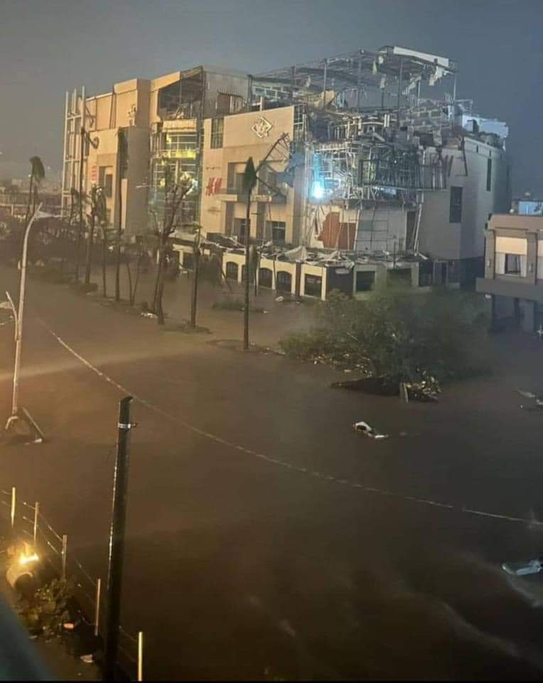
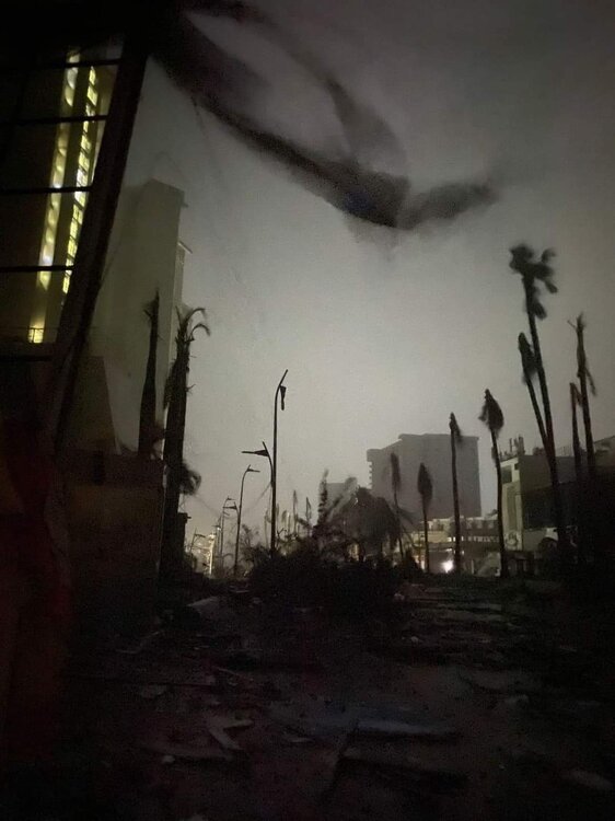
I can only imagine the damage, especially given very little notice for people in that area of Mexico. Acapulco was at least spared the worst of the surge, being to the "left"/west of the storm's center, but areas 5-20 miles SE of the city likely saw catastrophic surge and winds, but wind damage was reportedly severe in the city with power out to nearly all of the 1MM people who live there. I'm sure we'll see more reports today. This will be Exhibit 356 on why people in the path of a tropical storm/hurricane ought to be prepared and/or evacuate (or be able to evacuate quickly if the forecast changes like this one).

https://www.wunderground.com/article/news/weather/news/2023-10-25-hurricane-otis-mexico-live-updates

BULLETIN
Hurricane Otis Intermediate Advisory Number 12A
NWS National Hurricane Center Miami FL EP182023
100 AM CDT Wed Oct 25 2023

...EYE OF CATEGORY 5 HURRICANE OTIS ABOUT TO MAKE LANDFALL NEAR
ACAPULCO MEXICO...
...CATASTROPHIC DAMAGE LIKELY WHERE THE CORE MOVES ONSHORE...


SUMMARY OF 100 AM CDT...0600 UTC...INFORMATION
----------------------------------------------
LOCATION...16.7N 99.8W
ABOUT 15 MI...25 KM SSE OF ACAPULCO MEXICO
MAXIMUM SUSTAINED WINDS...165 MPH...270 KM/H
PRESENT MOVEMENT...NNW OR 345 DEGREES AT 10 MPH...17 KM/H
MINIMUM CENTRAL PRESSURE...923 MB...27.26 INCHES
 
maxresdefault.jpg
 
I read an AP story recently about the increasing number of storms "turbocharging" or rapidly intensifying, which can make it difficult for people decide on whether to evacuate or shelter in place. I think you're screwed either way.
 
Holy crap, this is nearly unprecedented, as Otis was a tropical storm at 11 am EDT Tuesday morning with 70 mph winds and was forecast to strengthen to maybe 85-90 mph winds by landfall around 2:30 am this morning. No models had the storm going beyond Cat 2, but as I've said many times, hurricane intensity forecasts are often fairly inaccurate and storms often surprise us - but not to this extent. By 5 pm yesterday Otis was up to 125 mph and by 11 pm the storm was up to 160 mph and made landfall as a 165 mph Cat 5 storm about 5 miles SE of Acapulco.

I can only imagine the damage, especially given very little notice for people in that area of Mexico. Acapulco was at least spared the worst of the surge, being to the "left"/west of the storm's center, but areas 5-20 miles SE of the city likely saw catastrophic surge and winds, but wind damage was reportedly severe in the city with power out to nearly all of the 1MM people who live there. I'm sure we'll see more reports today. This will be Exhibit 356 on why people in the path of a tropical storm/hurricane ought to be prepared and/or evacuate (or be able to evacuate quickly if the forecast changes like this one).

https://www.wunderground.com/article/news/weather/news/2023-10-25-hurricane-otis-mexico-live-updates

BULLETIN
Hurricane Otis Intermediate Advisory Number 12A
NWS National Hurricane Center Miami FL EP182023
100 AM CDT Wed Oct 25 2023

...EYE OF CATEGORY 5 HURRICANE OTIS ABOUT TO MAKE LANDFALL NEAR
ACAPULCO MEXICO...
...CATASTROPHIC DAMAGE LIKELY WHERE THE CORE MOVES ONSHORE...


SUMMARY OF 100 AM CDT...0600 UTC...INFORMATION
----------------------------------------------
LOCATION...16.7N 99.8W
ABOUT 15 MI...25 KM SSE OF ACAPULCO MEXICO
MAXIMUM SUSTAINED WINDS...165 MPH...270 KM/H
PRESENT MOVEMENT...NNW OR 345 DEGREES AT 10 MPH...17 KM/H
MINIMUM CENTRAL PRESSURE...923 MB...27.26 INCHES
Surprise? My company has been tracking this storm for almost a week.
 
I read an AP story recently about the increasing number of storms "turbocharging" or rapidly intensifying, which can make it difficult for people decide on whether to evacuate or shelter in place. I think you're screwed either way.
This is one area where global warming is likely having an impact, as GW means warmer sea surface temps, in general (as they have been near Mexico and in much of the Atlantic Basin this year) and there is zero doubt that warmer SSTs can lead to more significant intensification - but there are other factors too, like wind shear, outflow dynamics, surrounding area humidity, etc.

For example Tammy, last week was traversing abnormally warm SSTs near the Leeward Islands, but never really intensified much due to significant wind shear and dry air entrainment, whereas Otis was over warm waters and shear was rapidly decreasing - which is why it's a surprise that the models didn't pick up on the RI cycle. Can't wait to see the post-mortem on this one.
 
  • Like
Reactions: RUDiddy777
Surprise? My company has been tracking this storm for almost a week.
You're not being serious are you? I've been tracking this for as long, but it wasn't noteworthy until it underwent "surprise" rapid intensification from 70 mph to 160 mph in 12 hours. No models predicted this.
 
  • Like
Reactions: LETSGORU91
You're not being serious are you? I've been tracking this for as long, but it wasn't noteworthy until it underwent "surprise" rapid intensification from 70 mph to 160 mph in 12 hours. No models predicted this.
Completely serious. My group as part of our supply chain is focused on managing risk of an event or a supplier causing a disruption in either our operations or the operations of our suppliers. We've been tracking and sending out internal alerts about this storm for the past week. Also closely tracking Tammy as it will turn west tomorrow towards the US. Our group was started at the beginning of Covid and, partly as a result, none of our 35 manufacturing plants in the US has experienced a shutdown or disruption during Covid or since. Came close a couple times during Covid. Just building an inventory buffer is not the solution in many of our plants where they receive 40-60 trucks or railcars of incoming bulk materials daily (just can't store that amount of material) and between 100-150 outbound trucks daily so our inventory buffer in these plants is literally hours.

The company manufactures roofing. Basically any type of roof you want, we make (don't install). We also do an analysis after each event and by the next day we have good estimates in terms of how many roofs were damaged, need repair, need replacement, etc. and quickly begin moving supplies into the affected areas.
 
Last edited:
Completely serious. My group as part of our supply chain is focused on managing risk of an event or a supplier causing a disruption in either our operations or the operations of our suppliers. We've been tracking and sending out internal alerts about this storm for the past week. Also closely tracking Tammy as it will turn west tomorrow towards the US. Our group was started at the beginning of Covid and, partly as a result, none of our 35 manufacturing plants in the US has experienced a shutdown or disruption during Covid or since. Came close a couple times during Covid. Just building an inventory buffer is not the solution in many of our plants where they receive 40-60 trucks or railcars of incoming bulk materials daily (just can't store that amount of material) and between 100-150 outbound trucks daily so our inventory buffer in these plants is literally hours.

The company manufactures roofing. Basically any type of roof you want, we make (don't install). We also do an analysis after each event and by the next day we have good estimates in terms of how many roofs were damaged, need repair, need replacement, etc. and quickly begin moving supplies into the affected areas.
There it is.. the "invisible hand" functioning so much better than any socialist bureaucrat can manage a piece of an economy.
 
  • Like
Reactions: letitrip2
Completely serious. My group as part of our supply chain is focused on managing risk of an event or a supplier causing a disruption in either our operations or the operations of our suppliers. We've been tracking and sending out internal alerts about this storm for the past week. Also closely tracking Tammy as it will turn west tomorrow towards the US. Our group was started at the beginning of Covid and, partly as a result, none of our 35 manufacturing plants in the US has experienced a shutdown or disruption during Covid or since. Came close a couple times during Covid. Just building an inventory buffer is not the solution in many of our plants where they receive 40-60 trucks or railcars of incoming bulk materials daily (just can't store that amount of material) and between 100-150 outbound trucks daily so our inventory buffer in these plants is literally hours.

The company manufactures roofing. Basically any type of roof you want, we make (don't install). We also do an analysis after each event and by the next day we have good estimates in terms of how many roofs were damaged, need repair, need replacement, etc. and quickly begin moving supplies into the affected areas.
My (minor) issue was with you questioning the use of "surprise" - it wasn't a surprise storm at all, as anyone could've tracked this one since its inception - the "surprise" was the unforecast and unprecedented rapid intensification that no models or humans predicted. As an aside, it seems very unlikely that Tammy will affect the US, but one never knows for sure...

I am curious on the supply chain effort you're involved with. Are you the one doing the forecasting or the communications or both? Sounds like interesting work. When I was at Merck, I started sending out winter weather emails (kind of like my posts here) to a small group of snowboard/ski nuts in my area in the early 2000s and I added tropical notes in the mid-2000s and the list grew from about 15 to several hundred people by about 2010 and by then, my old boss had moved up to SVP in manufacturing and he asked me to include a group of manufacturing site heads and supply chain leaders in his group, as he liked getting that content and being able to give people a heads up on storms (especially hurricanes).

I remember telling them that I enjoyed helping out, but this was being done in my spare time (my responsibilities were overseeing groups doing process development and transfer to manufacturing) and I recommended they actually find someone to oversee a more global, connected effort on this and I heard that they implemented something after I left (at the start of COVID also). Sounds similar to what you're involved with.
Tammy models have it potentially hitting between Florida and North Carolina, or turning north again and staying off coast. We really won't know until it turns west. I'm not sure I would say unlikely to hit US just yet. We have an internal program that can overlay a storm's path over our locations and our supplier locations so we can easily see who may be affected.
 
Last edited:
My (minor) issue was with you questioning the use of "surprise" - it wasn't a surprise storm at all, as anyone could've tracked this one since its inception - the "surprise" was the unforecast and unprecedented rapid intensification that no models or humans predicted. As an aside, it seems very unlikely that Tammy will affect the US, but one never knows for sure...

I am curious on the supply chain effort you're involved with. Are you the one doing the forecasting or the communications or both? Sounds like interesting work. When I was at Merck, I started sending out winter weather emails (kind of like my posts here) to a small group of snowboard/ski nuts in my area in the early 2000s and I added tropical notes in the mid-2000s and the list grew from about 15 to several hundred people by about 2010 and by then, my old boss had moved up to SVP in manufacturing and he asked me to include a group of manufacturing site heads and supply chain leaders in his group, as he liked getting that content and being able to give people a heads up on storms (especially hurricanes).

I remember telling them that I enjoyed helping out, but this was being done in my spare time (my responsibilities were overseeing groups doing process development and transfer to manufacturing) and I recommended they actually find someone to oversee a more global, connected effort on this and I heard that they implemented something after I left (at the start of COVID also). Sounds similar to what you're involved with.
Regarding my work I'm partially helping with the forecasting but involved with the communication, developing & implementing mitigation plans. I created an algorithm a number of years ago that we employ to calculate supplier risk, basically the risk of a supplier disrupting our operation, and a process to assess and communicate the probability of a disruption occurring and, if one occurs, the severity of its impact on the business. We also contract a service that provides a steady stream of hourly alerts regarding things happening around the world that may affect our business. Our and our supplier locations are programmed into their system. Not uncommon for us to receive an alert about a fire at a supplier, we reach out to them to see if we will be affected and the person we initially speak doesn't even know yet they had a fire.
 
Last edited:
  • Like
Reactions: RU848789
Any chance the earlier measurements of the storm were just wrong? Some competency issue rear its ugly head? Or is it all satellite data that just cannot be wrong?
 
  • Like
Reactions: RUfinally2008
ques·tion
/ˈkwesCH(ə)n/

noun
a sentence worded or expressed so as to elicit information.
"we hope this leaflet has been helpful in answering your questions"

verb
ask questions of (someone), especially in an official context.
"four men were being questioned about the killings"
 
Sobering videos of major to catastrophic damage in Acapulco, even to high rises. Can only imagine how the poorer areas in the countryside did. First ever Cat 5 to make landfall in the Eastern Pacific region (which is essentially just Mexico, since Cali is too far north and Central America is too far south for major hurricanes in the Pacific).

https://twitter.com/hashtag/Acapulco?src=hashtag_click
 
  • Wow
Reactions: Postman_1
Any chance the earlier measurements of the storm were just wrong? Some competency issue rear its ugly head? Or is it all satellite data that just cannot be wrong?
Satellite measurements can be off, especially in rapidly intensifying cyclones, as they were at 4 pm yesterday, when the NHC noted that the satellite estimates were well below the winds measured by an AF hurricane hunter. That's why aerial reconnaissance is still so important. I'm sure we'll see a detailed post-mortem at some point as this is one of the bigger rapid intensification misses we've seen in years. Having said that, there at least was some indication that we might see rapid intensification well above what was forecast, as per the 10 am CDT update yesterday, excerpted below.

https://www.nhc.noaa.gov/archive/2023/OTIS.shtml?

Hurricane Otis Discussion Number 10
NWS National Hurricane Center Miami FL EP182023
400 PM CDT Tue Oct 24 2023

Otis has undergone very rapid intensification today. An eye became
apparent on visible satellite images only a few hours ago, embedded
in very deep convection. An Air Force Hurricane Hunter aircraft
penetrated the eye around 1900 UTC and again around 2000 UTC, and
found that the maximum sustained winds had increased to near 110 kt
over a very small area near the center, while the central pressure
remarkably dropped around 10 mb from the first to the second center
fix. The intensity of Otis is well above the Dvorak satellite
estimates, and again underscores the value of aerial reconnaissance

in monitoring hurricanes.

Tropical Storm Otis Discussion Number 9
NWS National Hurricane Center Miami FL EP182023
1000 AM CDT Tue Oct 24 2023

Satellite imagery indicates that Otis continues to become better
organized. There is very cold-topped convection with the Central
Dense Overcast surrounded by a number of convective banding
features. Upper-level outflow is well-defined over most of the
circulation. Subjective Dvorak intensity estimates range from
55 to 65 kt and the current intensity estimate is set at 60 kt
for this advisory. An Air Force Reserve Unit Hurricane Hunter
aircraft is scheduled to investigate Otis this afternoon, which
should provide a good estimate of the intensity of the tropical
cyclone.

Sea surface temperatures are very warm, around 30 deg C, and the
low-to mid-level humidities are fairly high. There is weak to
moderate south-southeasterly shear over the system, which is
located on the western periphery of an upper-tropospheric
anticyclone.
Steady strengthening seems likely until Otis makes
landfall within the next day or so. Based on the current
trends, the official intensity forecast is above most of the model
guidance. The SHIPS Rapid Intensification (RI) indices show a
greater than normal probability of RI, so some further upward
adjustments to the intensity forecast are possible later today.
Otis should rapidly weaken over the mountains of Mexico after it

moves inland.
 
Tammy models have it potentially hitting between Florida and North Carolina, or turning north again and staying off coast. We really won't know until it turns west. I'm not sure I would say unlikely to hit US just yet. We have an internal program that can overlay a storm's path over our locations and our supplier locations so we can easily see who may be affected.
I would still say pretty unlikely to impact the US looking at the global models (and especially the Euro). Sure there are some obscure models and some ensemble members of the globals showing paths towards the US or hitting the US, but most of these are as a very weak post-tropical system. Can't rule it out completely, but that's not the way to bet.
 
Regarding my work I'm partially helping with the forecasting but involved with the communication, developing & implementing mitigation plans. I created an algorithm a number of years ago that we employ to calculate supplier risk, basically the risk of a supplier disrupting our operation, and a process to assess and communicate the probability of a disruption occurring and, if one occurs, the severity of its impact on the business. We also contract a service that provides a steady stream of hourly alerts regarding things happening around the world that may affect our business. Our and our supplier locations are programmed into their system. Not uncommon for us to receive an alert about a fire at a supplier, we reach out to them to see if we will be affected and the person we initially speak doesn't even know yet they had a fire.
Sounds pretty cool, thanks.
 
I would still say pretty unlikely to impact the US looking at the global models (and especially the Euro). Sure there are some obscure models and some ensemble members of the globals showing paths towards the US or hitting the US, but most of these are as a very weak post-tropical system. Can't rule it out completely, but that's not the way to bet.
Models are now showing it is either breaking or continuing north or northeast and to not impact the US coast.
 
There it is.. the "invisible hand" functioning so much better than any socialist bureaucrat can manage a piece of an economy.
You do know that the US government developed the satellites that track storms right? I don’t think those guys were socialists. And that Adam Smith, who coined the phrase “invisible hand” used it to explain how markets work, but also recognized, and clearly stated, the need for a government role in the economy? You need both.
 
You do know that the US government developed the satellites that track storms right? I don’t think those guys were socialists. And that Adam Smith, who coined the phrase “invisible hand” used it to explain how markets work, but also recognized, and clearly stated, the need for a government role in the economy? You need both.
Where do you think we get some of our data? The US Government may track storms but they don't do the work to translate that into how it impacts our business (before, during and after the storm). We have our own models that highlight supplier or material risk. That leads us to do work to put in place plans to react to storms, ie change production locations, move to alternate suppliers, move railcars out of the storm area before the storm, etc. Is the government going to do that for us?
 
Where do you think we get some of our data? The US Government may track storms but they don't do the work to translate that into how it impacts our business (before, during and after the storm). We have our own models that highlight supplier or material risk. That leads us to do work to put in place plans to react to storms, ie change production locations, move to alternate suppliers, move railcars out of the storm area before the storm, etc. Is the government going to do that for us?
I understand that. I was commenting on the ”socialist” comment Good Ole Rutgers made. in your case government provides some of the basic, raw info and you build from it. Good, that’s what works best in many cases. I did the same thing in my career.
 
You do know that the US government developed the satellites that track storms right? I don’t think those guys were socialists. And that Adam Smith, who coined the phrase “invisible hand” used it to explain how markets work, but also recognized, and clearly stated, the need for a government role in the economy? You need both.
Oh.. did US government workers build them?

Man, your are really bending over backwards to make a point about socialism that actually shows you the benefits of capitalism to government purchases.

Government's great achievements are largely due to capitalism.

Now its time for someone to chime in with "unbridled capitalism".. as if that exists anywhere.
 
Last edited:
ADVERTISEMENT
ADVERTISEMENT