That’s a fail. Maine announced yesterday evening the game was moved to Friday at 6:30 to get ahead of the storm.
Did not know that, good for them.


Follow along with the video below to see how to install our site as a web app on your home screen.
Note: This feature may not be available in some browsers.
That’s a fail. Maine announced yesterday evening the game was moved to Friday at 6:30 to get ahead of the storm.
Hookers and blow?
Hookers and blow have been scientifically established to extend life.Hookers and blow?
I'm publishing one any day now.Well those studies involved human hookers: I don't think they considered barnyard hookers.
Well those studies involved human hookers: I don't think they considered barnyard hookers.
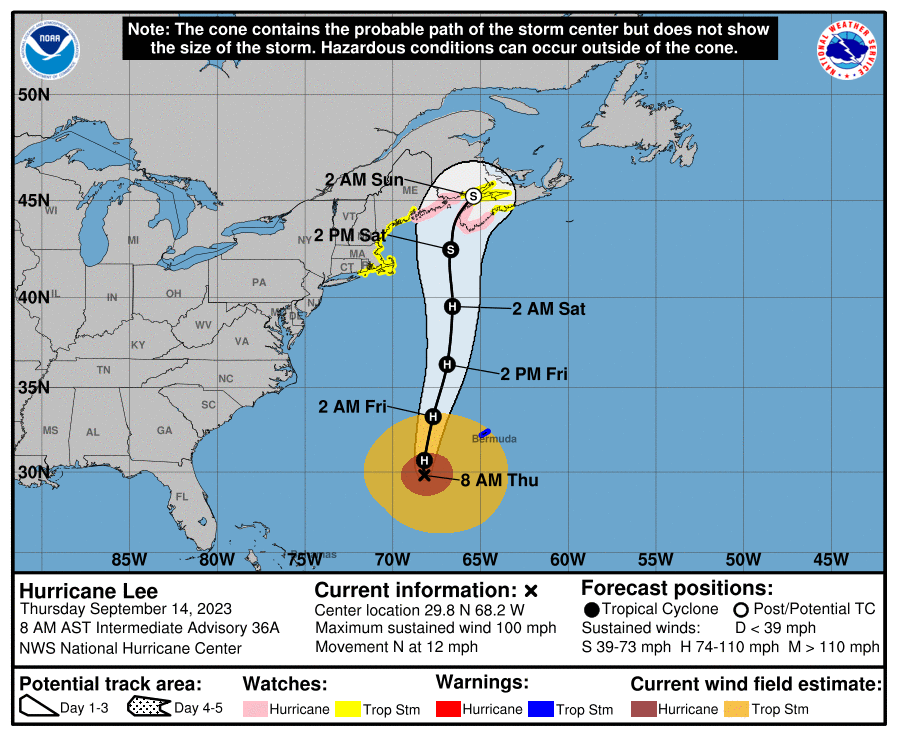
Lee continues to weaken and is now down to 85 mph, but the windfield has expanded, meaning the overall power of the storm (the integrated kinetic energy of the entire windfield) hasn't really changed much as hurricane force winds extend out ~100 miles from the storm's center and tropical storm force winds extend out up to 340 miles from the storm's center.No significant changes overnight as the 0Z models are almost all showing landfall between Downeast Maine and SW Nova Scotia, with the center of the forecast track still grazing the western tip of NS as a ~70 mph storm transitioning to extratropical and slamming into New Brunswick, Canada near Saint John. The surge forecast from last night is the same, but the rainfall forecast was increased, as per below and the updated track guidance is also below. Impacts are about the same as detailed last night, too. This is going to be a very impactful storm for much of central/eastern Maine and most of New Brunswick/Nova Scotia, including well inland. Minor to moderate impacts are likely for the rest of SE New England, except for the higher storm surge for Cape Cod.
FORECAST POSITIONS AND MAX WINDS
INIT 14/0900Z 29.1N 68.1W 85 KT 100 MPH
12H 14/1800Z 30.7N 68.2W 80 KT 90 MPH
24H 15/0600Z 33.3N 67.7W 80 KT 90 MPH
36H 15/1800Z 36.3N 66.9W 75 KT 85 MPH
48H 16/0600Z 39.5N 66.6W 70 KT 80 MPH
60H 16/1800Z 42.5N 66.7W 60 KT 70 MPH
72H 17/0600Z 45.2N 65.4W 50 KT 60 MPH...POST-TROP/EXTRATROP
96H 18/0600Z 50.2N 58.1W 40 KT 45 MPH...POST-TROP/EXTRATROP
120H 19/0600Z 54.6N 45.8W 40 KT 45 MPH...POST-TROP/EXTRATROP
I have a house ocean side on the cape, have used this for positive reinforcement to my wife that there is nothing to worry about despite the nightly news pumping up the threat. Pleased that it is a glorified thunderstorm, and appreciative of the info at my fingertips.After all this hot air and tons of meaningless posts, this "hurricane" may make landfall as a glorified thunderstorm.
LOL!

 streampros.net
After all this hot air and tons of meaningless posts, this "hurricane" may make landfall as a glorified thunderstorm.
LOL!
Would have saved a lot of time using weather.com. Same info, but without delays.Which is good information to have to those interested or possibly affected
Would have saved a lot of time using weather.com. Same info, but without delays.
Based on that logic we could get rid of the CE board and all just read CNN and Fox, we could drop premium and just read ESPN. Maybe no game threads and all just actually watch the games………Would have saved a lot of time using weather.com. Same info, but without delays.

Great post. There are all kinds of threads I don't post in, because I'm either not interested or don't have much to add, but I don't go into them and troll the folks who are interested in that topic. The crux of it is a few posters just like to troll threads, especially the weather threads. The fascinating thing is I post just about the same info on multiple other message boards and on Facebook (and send to about ~500 folks on my email lists who prefer that over social media) and this board is the only place I get trolled. That tells me it's not me. I'll never really understand trolling, but clearly there are people who just love the attention, even if it's mostly negative attention.Based on that logic we could get rid of the CE board and all just read CNN and Fox, we could drop premium and just read ESPN. Maybe no game threads and all just actually watch the games………
This is a forum where people discuss and share things and don’t act like sheep and just follow what the media tells us, and trust me TWC and Weather.com has been hyping this for a least a week.
T2Kplus the media following lamb, go figure….
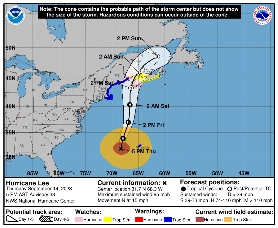
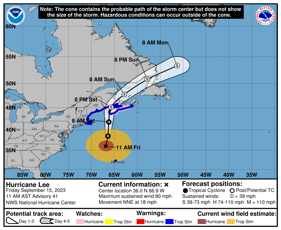
Very little forecast change, so will just include the updated forecast positions/winds and track map. Landfall still looks to be right on the western edge of Nova Scotia or perhaps in New Brunwsick, Canada if the track nudges west a little, as a ~70 mph storm with hurricane force gusts that will be transitioning to an extratropical storm at that time. Maine is out of the woods for landfall, although that doesn't matter much given the very large windfield with the storm - they'll still likely get 60-70 mph winds in eastern Maine (as well as a bit inland in ME/Canada). The surge and rainfall forecasts are very similar to the ones quoted in the post above.Lee continues to weaken and is now down to 85 mph, but the windfield has expanded, meaning the overall power of the storm (the integrated kinetic energy of the entire windfield) hasn't really changed much as hurricane force winds extend out ~100 miles from the storm's center and tropical storm force winds extend out up to 340 miles from the storm's center.
The forecast for when Lee reaches Maine/Canada is largely unchanged, as the storm is expected to have winds of ~70 mph (with hurricane force gusts) when it probably makes landfall on the far western tip of Nova Scotia or just grazes that area on its way to striking New Brunswick Canada a bit NE of there. A Maine landfall is looking unlikely now, although it's still in the cone; however, eastern Maine will still likely be getting 60-70 mph winds, even inland, as will inland areas in NB/NS Canada. This level of winds will likely cause some damage in eastern Maine and NB/NS, including inland, including some downed trees and power outages. Wind damage is a lot less likely in the rest of New England.
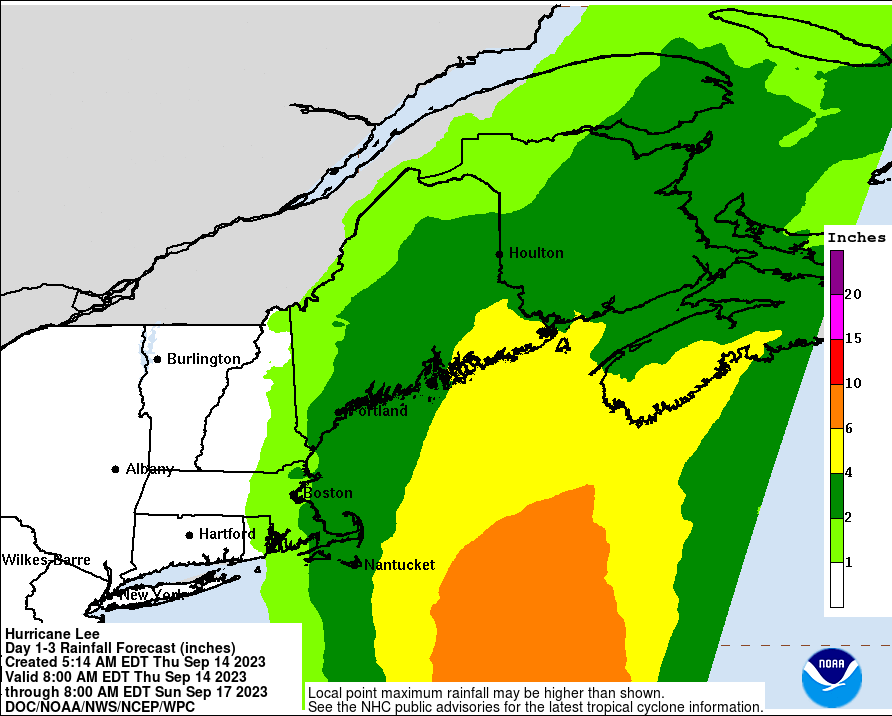
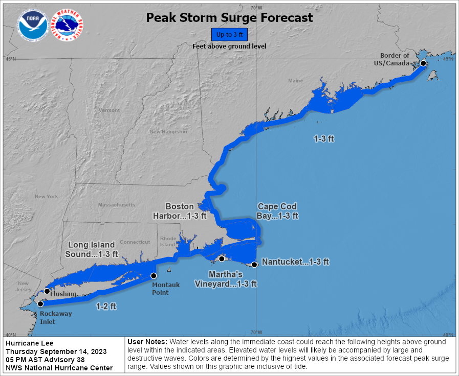
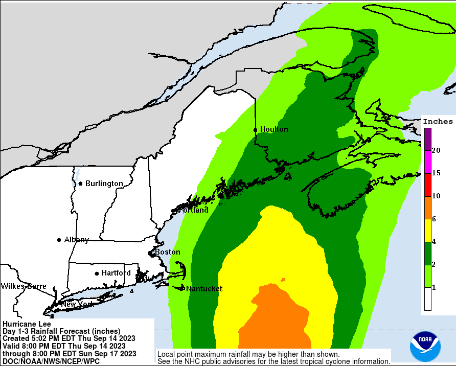
The only change to the storm surge forecast was to drop the surge watch for Cape Cod, as the whole New England coast is now forecast to get 1-3 feet of surge, which will likely cause some moderate, but not catastrophic damage, as this is similar to what this area often gets in very strong nor'easters. And the rainfall forecast was reduced for areas in SE MA/NH and western ME with <1" forecast for those areas, except for 1-2" forecast for Cape Cod (the map below doesn't show rainfall <1" for some reason). Rainfall forecasts for eastern Maine and NB/NS Canada are for a general 2-4", including well inland. This amount of rain will definitely produce some flooding, given antecedent saturated conditions.
FORECAST POSITIONS AND MAX WINDS
INIT 14/2100Z 31.7N 68.3W 75 KT 85 MPH
12H 15/0600Z 33.8N 67.9W 75 KT 85 MPH
24H 15/1800Z 37.0N 66.9W 75 KT 85 MPH
36H 16/0600Z 40.3N 66.6W 70 KT 80 MPH
48H 16/1800Z 43.3N 66.4W 60 KT 70 MPH...POST-TROP/EXTRATROP
60H 17/0600Z 46.0N 65.0W 45 KT 50 MPH...POST-TROP/EXTRATROP
72H 17/1800Z 48.6N 61.4W 40 KT 45 MPH...POST-TROP/EXTRATROP
96H 18/1800Z 53.7N 48.0W 35 KT 40 MPH...POST-TROP/EXTRATROP
120H 19/1800Z...DISSIPATED
https://www.nhc.noaa.gov/refresh/graphics_at3+shtml/150936.shtml?cone#contents
Oh its a bit you, but thats another point 😂😂😂. Happy to see you didnt say the weather for va tech was a lockGreat post. There are all kinds of threads I don't post in, because I'm either not interested or don't have much to add, but I don't go into them and troll the folks who are interested in that topic. The crux of it is a few posters just like to troll threads, especially the weather threads. The fascinating thing is I post just about the same info on multiple other message boards and on Facebook (and send to about ~500 folks on my email lists who prefer that over social media) and this board is the only place I get trolled. That tells me it's not me. I'll never really understand trolling, but clearly there are people who just love the attention, even if it's mostly negative attention.
Maybe a little, but 99% of the time I get testy is in response to someone else going there first - and yeah, I could ignore more of the crap, but what can I say? I like to argue for sport sometimes.Oh its a bit you, but thats another point 😂😂😂. Happy to see you didnt say the weather for va tech was a lock
Heh heh, uh, heh heh. He said testes. Heh heh.Maybe a little, but 99% of the time I get testy is in response to someone else going there first

Lee has officially been deemed an extratropical storm, but it still is a a hybrid with some tropical and mostly non-tropical characteristics, but that's just semantics as the storm is still packing Cat 1 hurricane winds of 80 mph. Unlike Sandy, where "hurricane" and "tropical storm" warnings were dropped when the storm was deemed extratropical before landfall, the NHC now still uses those terms so people don't let their guard down (as some did with Sandy as no TS or hurricane watches/warnings were ever posted in NJ/NY, since it was forecast to not be tropical at landfall, yet we obviously had a "hurricane" at landfall) as 70-75 mph winds are still hurricane strength regardless of the designation of the storm.Very little forecast change, so will just include the updated forecast positions/winds and track map. Landfall still looks to be right on the western edge of Nova Scotia or perhaps in New Brunwsick, Canada if the track nudges west a little, as a ~70 mph storm with hurricane force gusts that will be transitioning to an extratropical storm at that time. Maine is out of the woods for landfall, although that doesn't matter much given the very large windfield with the storm - they'll still likely get 60-70 mph winds in eastern Maine (as well as a bit inland in ME/Canada). The surge and rainfall forecasts are very similar to the ones quoted in the post above.
https://www.nhc.noaa.gov/refresh/graphics_at3+shtml/145447.shtml?cone#contents
FORECAST POSITIONS AND MAX WINDS
INIT 15/1500Z 36.0N 66.9W 70 KT 80 MPH
12H 16/0000Z 38.5N 66.4W 70 KT 80 MPH
24H 16/1200Z 41.8N 66.2W 65 KT 75 MPH
36H 17/0000Z 45.1N 65.7W 55 KT 65 MPH...POST-TROP/EXTRATROP
48H 17/1200Z 47.8N 62.8W 45 KT 50 MPH...POST-TROP/EXTRATROP
60H 18/0000Z 50.8N 57.8W 40 KT 45 MPH...POST-TROP/EXTRATROP
72H 18/1200Z 53.4N 51.3W 35 KT 40 MPH...POST-TROP/EXTRATROP
96H 19/1200Z...DISSIPATED
You are the most sensitive person on the board (now that AlbanyKnight is gone) and get most hysterical about weather threads. Not complicated.Maybe a little, but 99% of the time I get testy is in response to someone else going there first - and yeah, I could ignore more of the crap, but what can I say? I like to argue for sport sometimes.
Anyway, I did say lock it up for VT being gorgeous weather on Sunday night - just never got around to changing the thread title. This game was a pretty easy weather lock, just like NW was and unlike Temple, obviously.
You are the most sensitive person on the board (now that AlbanyKnight is gone) and get most hysterical about weather threads. Not complicated.
Every troller needs a willing trollee to make this work. Enjoy the game! Bac said the weather is going to be wonderful.
Last I checked, I was still a US citizen living up here in Maine.To summarize, glorified thunderstorm not directly impacting the US (or even Bermuda).
#fishstorm
 streampros.net
