ADVERTISEMENT

Watching Wednesday Snow to Rain Event Thread

Status
Not open for further replies.
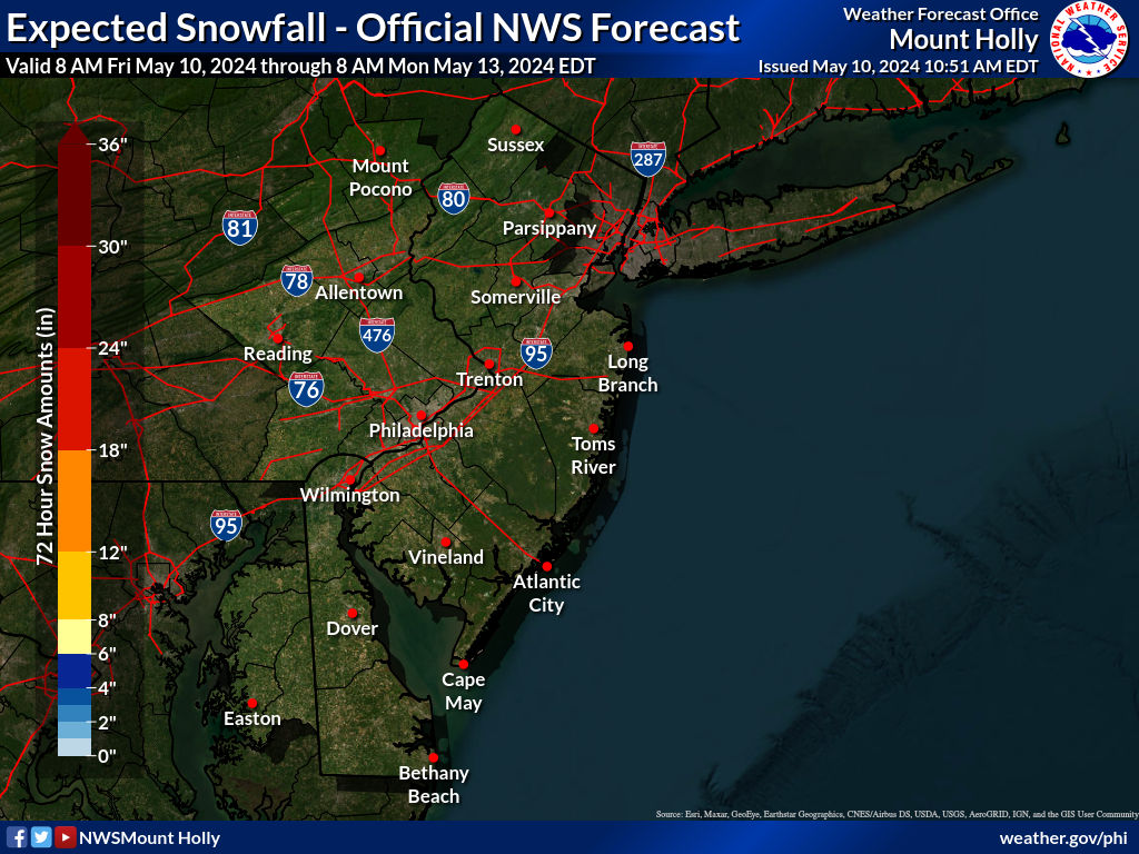
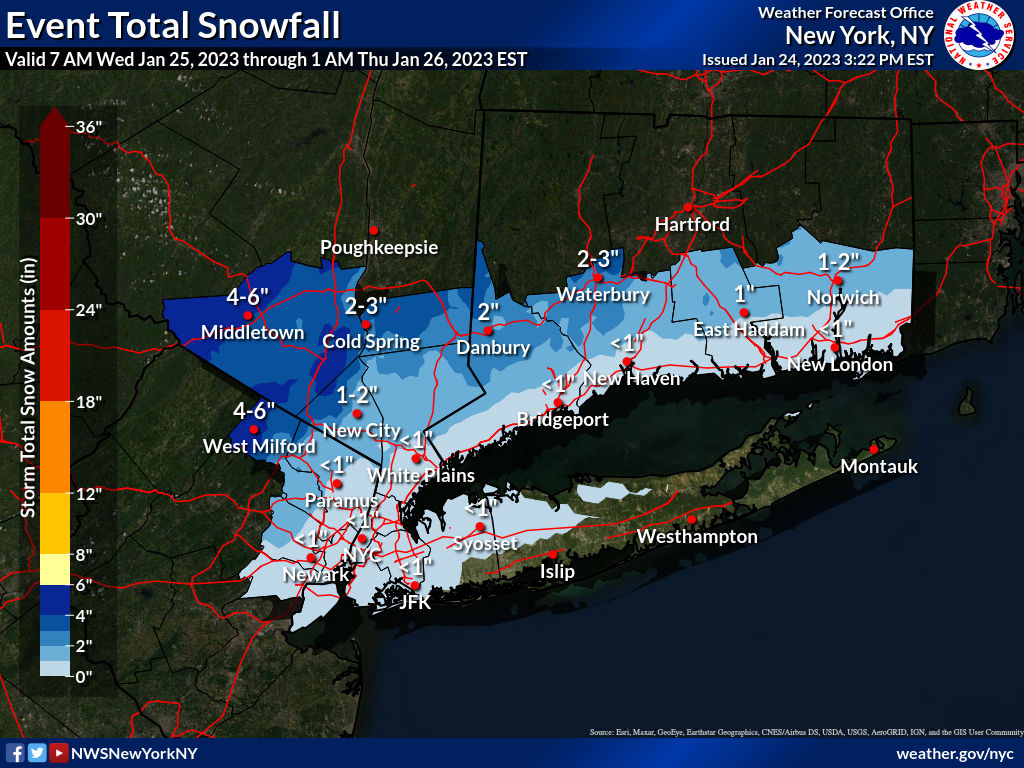
this map is actually more than generous for central jersey but I get why they need to play on the safe side

StormTotalSnowWeb.jpg
 
Well, as usual this winter, our snow potential keeps dwindling as we get closer to the event. Forecast is now for maybe a coating to 1/2" for the 95 corridor from Philly-NJ-NYC at the start of tomorrow's event (late morning/early afternoon), with any snow (could easily be a Blutarskyesque 0.0") quickly changing to rain, as warm air screams in off the warm ocean and from our SW, with 1-2" of rain looking likely for almost the entire region. It's now possible that NYC, Philly, Balt/DC will all continue their near record stretches of no measurable snow for 320+ days (NYC is most likely of these to at least get 0.1" of snow); the record is 332 days for NYC. By the way, no record for Newark, as they got 0.1" of snow back in Dec. (as did LGA and JFK, but not CPK, which is NYC's "official" station of record).

The only areas that will get less than 1" of rain are the NW areas that get several inches of snow first, i.e., the Poconos, NW Sussex, the Catskills, etc., where 3-6" will likely accumulate before a change to sleet and probably rain (maybe no rain for the Catskills and interior New England at higher elevations, where up to 8" could fall - hence the winter storm warnings for those areas). Advisories are up for Carbon/Monroe and Sussex/W. Passaic and Orange for 3-6" of snow potential and are also up for the Lehigh Valley, Warren, Morris, Putnam and interior CT for a general 1-3" of front end snow.

1-2" of rain will likely bring some urban and small stream flooding (minor, not major), given lots of recent rains; some minor coastal flooding is also likely with the Weds night high tide and wind advisories are up for coastal NJ and LI for gusts up to 45 mph, as the secondary coastal low (moving across coastal NJ - hence the warm air) takes over later on Wednesday evening. Links and a couple of relevant snowfall maps below.

https://www.weather.gov/phi/
https://www.33andrain.com/.../2126-125-east-coast.../page/5/

tgt0lJK.png


q6cGvHp.png
 
Here's an updated NWS-Philly map; the one bac posted is from this morning, although changes were pretty minor - mostly a little less snow for most (but a little more well NW), which might mean 0 for much of the 95 corridor. The updated NWS-NYC map is also below.

5TcOsef.png


R25w7Cb.png
 
  • Like
Reactions: Knight Shift
This one is just about over for anyone south of 78 (except maybe a 1/2" a little bit south of 78 in Hunterdon and EPA) , given that only one model shows snow south of 78 (the GFS, which shows an inch or so before the rain, but the GFS is likely out to lunch), so the NWS has adjusted the 0" line northward, as per the map below. Now I'm just pulling for mood flakes and maybe a dusting here, but even that's in jeopardy.

Snowfall forecasts for the advisory counties to the N/W in EPA, NNJ, and NY haven't really changed much. Lots of rain coming for almost everyone (1-2"), so urban/stream flooding is possible and minor tidal flooding is likely and wind advisories are still up for the NJ/NY coast for gusts up to 50 mph.

1VUupx1.png
 
  • Like
Reactions: Zak57
Radar has been showing rain in Philly for awhile but nothing is hitting the ground. Most have been very dry air before it started.
 
Snowing pretty hard in Summit for a little while now. Looking out my office window, the parked cars have a decent covering and so do the building roofs. Roads have a very light coating, but had nothing not long ago. Come on rain!
 
Reports of 1" in Basking Ridge, mostly on grass/colder surfaces. Similar amounts NW where some accumulation is on the roads, as it's colder.
Roads and sidewalks were indeed covered here in downtown Summit, but now looks to be melting already. Cars got a nice coating. Couldn't even see the park in the distance a little bit ago - was snowing that hard. Has slowed down to barely anything now, and maybe changing over. Grass is white though - can see that now. Going to go out for a walk and check it out.
 
Still snowing in Whitehouse Station. No where near anything measurable but enough to look nice. I think the changeover to rain will be starting soon.
 
So you’re making threads for non events after killing RU NUMBERS for years making threads for non events. Ok

???

Two days before on a potential event that was uncertain to happen

Very odd post

This was an appropriate heads up thread to let people know of something within 48 hours

This wasnt a 5-7 knashing of teeth over models runs

Oh and save your response trying to troll bac@me
 
???

Two days before on a potential event that was uncertain to happen

Very odd post

This was an appropriate heads up thread to let people know of something within 48 hours

This wasnt a 5-7 knashing of teeth over models runs

Oh and save your response trying to troll bac@me
Why do some posters go so crazy about weather threads? Grow up people! I appreciate Bac's info and efforts.
 
???

Two days before on a potential event that was uncertain to happen

Very odd post

This was an appropriate heads up thread to let people know of something within 48 hours

This wasnt a 5-7 knashing of teeth over models runs

Oh and save your response trying to troll bac@me

You made fun of numbers posting about storms all the time that were minor nuances. And you just admitted this was always a “non-event”…so I’m just curious what made you post.

Did you think it would be a bigger event…hence why you posted? And hence yes…the thread did bust.
 
  • Like
Reactions: NotInRHouse
Saw a good burst of wet snow around 2 pm in North Plainfield that stuck a little to cars and the grass but quickly went over to rain. Got a brief dry spell around 4:30 pm that allowed me to get the dog out. This time is referred to as a poop slot not a dry slot. I’m sure the board has exhaled now that I filed my report.
 
  • Haha
Reactions: Jm0513 and WhiteBus
???

Two days before on a potential event that was uncertain to happen

Very odd post

This was an appropriate heads up thread to let people know of something within 48 hours

This wasnt a 5-7 knashing of teeth over models runs

Oh and save your response trying to troll bac@me
Fail ... the post and the thread.

Unless you're planning to create rain threads from here on out. That will be fun.
 
  • Like
Reactions: NotInRHouse
You made fun of numbers posting about storms all the time that were minor nuances. And you just admitted this was always a “non-event”…so I’m just curious what made you post.

Did you think it would be a bigger event…hence why you posted? And hence yes…the thread did bust.

Because he started threads 5-7 days before running train on models

I laid out the possibilities which included models 48 hours before showing some snow especially north of 78..
 
Because he started threads 5-7 days before running train on models

But why start a thread 2 days ago when you admitted today this was always going to be “a largely non-event”.????

This thread either busted..(it could have been an event, which is why you started it)….or you started a thread for a non event which I ask…why?
 
But why start a thread 2 days ago when you admitted today this was always going to be “a largely non-event”.????

This thread either busted..(it could have been an event, which is why you started it)….or you started a thread for a non event which I ask…why?

Models showed a potiential for some snow

Very simple
 
Did your wife really forbid you from buying premium...people are sayin
Be kinda of creepy-obsessive if anyone was sayin, just ... sayin.

Never had a use for premium, probably never will. Guess it's good for the increasingly paranoid loons who have to cower there solely because their rants are unwelcome on the free, public internet, including this site. Pretty pathetic to pay for that, but do what ya gotta do, I guess.
 
  • Like
Reactions: NotInRHouse
Status
Not open for further replies.
ADVERTISEMENT
ADVERTISEMENT