ADVERTISEMENT

OT: 12/16/20 Snowstorm Thread: First Significant Winter Storm of the Season - Major Snow/Sleet/Rain

To me, a storm is a bust only when very little snow falls. That wasn't true (I've got six inches on the ground in Cherry Hill, which is more than was forecast.) I think most everyone understands that predicting exact amounts, or even ranges, is practically impossible except with a lucky guess.
That may be YOUR definition of a bust, but meteorologically speaking it is but one of many /HTH
 
@RU848789

Numbers I dunno how to host and post an image but if you look at todays nam on tidbits and go back through the reanalysis you'll see the H7 low at 1pm yesterday was over Pittsburgh, and by 7 was over Harrisburg.
Yeah, was reading through the 33andrain thread and one of the mets said the 700 mbar low went through central PA, then just south of Binghamton and Albany and through MA, which is why many were postulating that the areas near and north of that got hammered so hard. Some also mentioned subsidence SE of that line being at least partly responsible for much of our area being either below or on the low end of snowfall forecasts (moreso than the sleet, which also didn't help).

Hard to predict that kind of banding - in fact, as I posted on 33, really only the CMC in the day or so leading up to the event got that banding even marginally right (post with models below), especially for VT/NH, which no other model came close on, plus the CMC got it right on its modeling of only 8-12" for 95 and even well into NNJ. But no mets can "know" that one is going to be right (especially when the CMC isn't usually, lol), which is why most go with model blends and some local knowledge and relying on some synoptic knowledge, like you and some others did on looking at the track being too close to the coast and the upper level lows going west likely leading to at least some sleet.


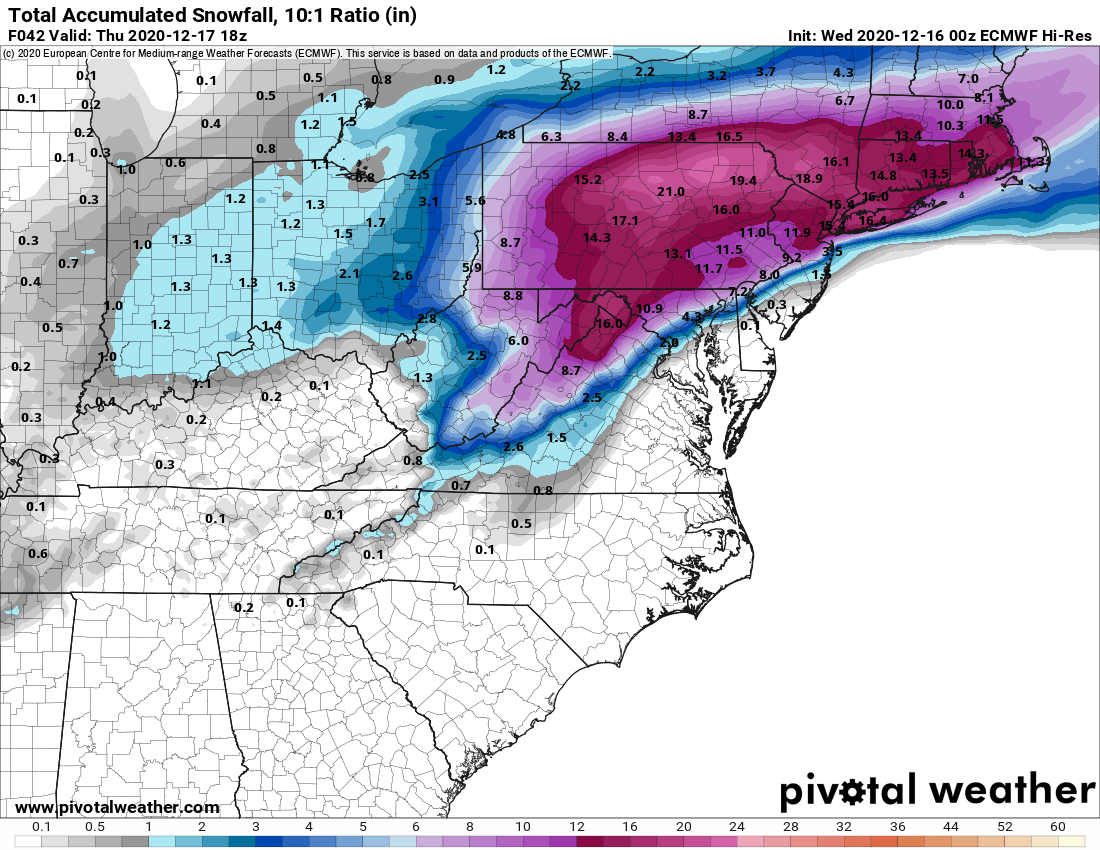
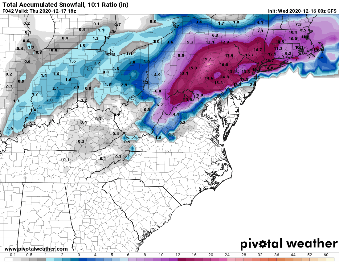
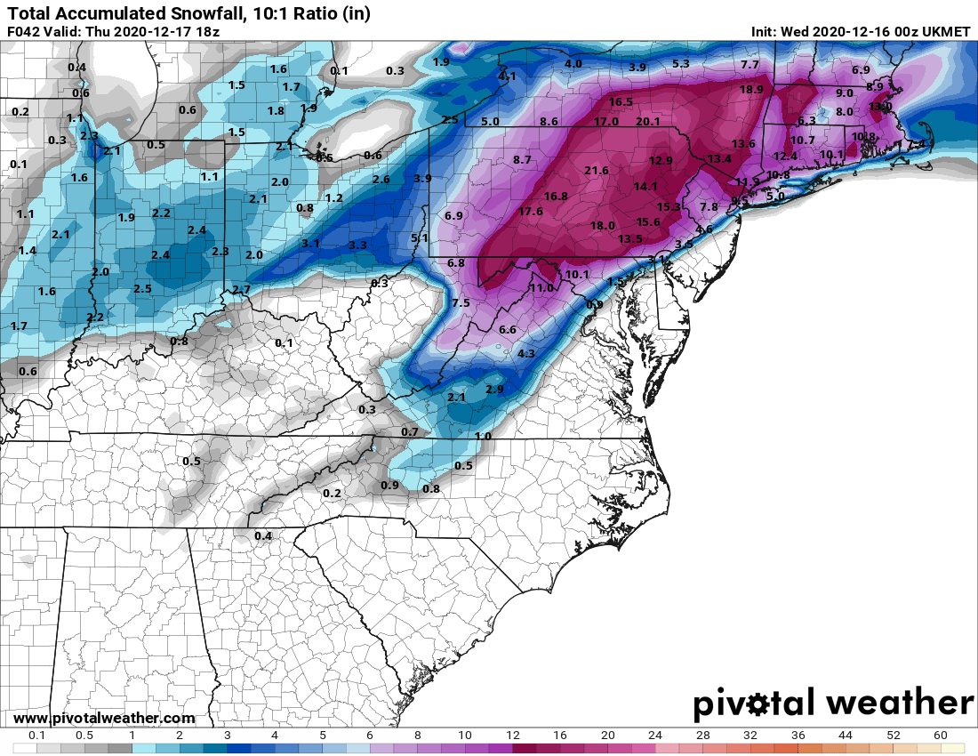
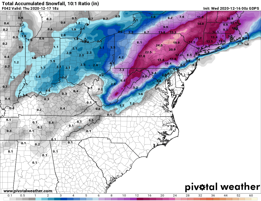
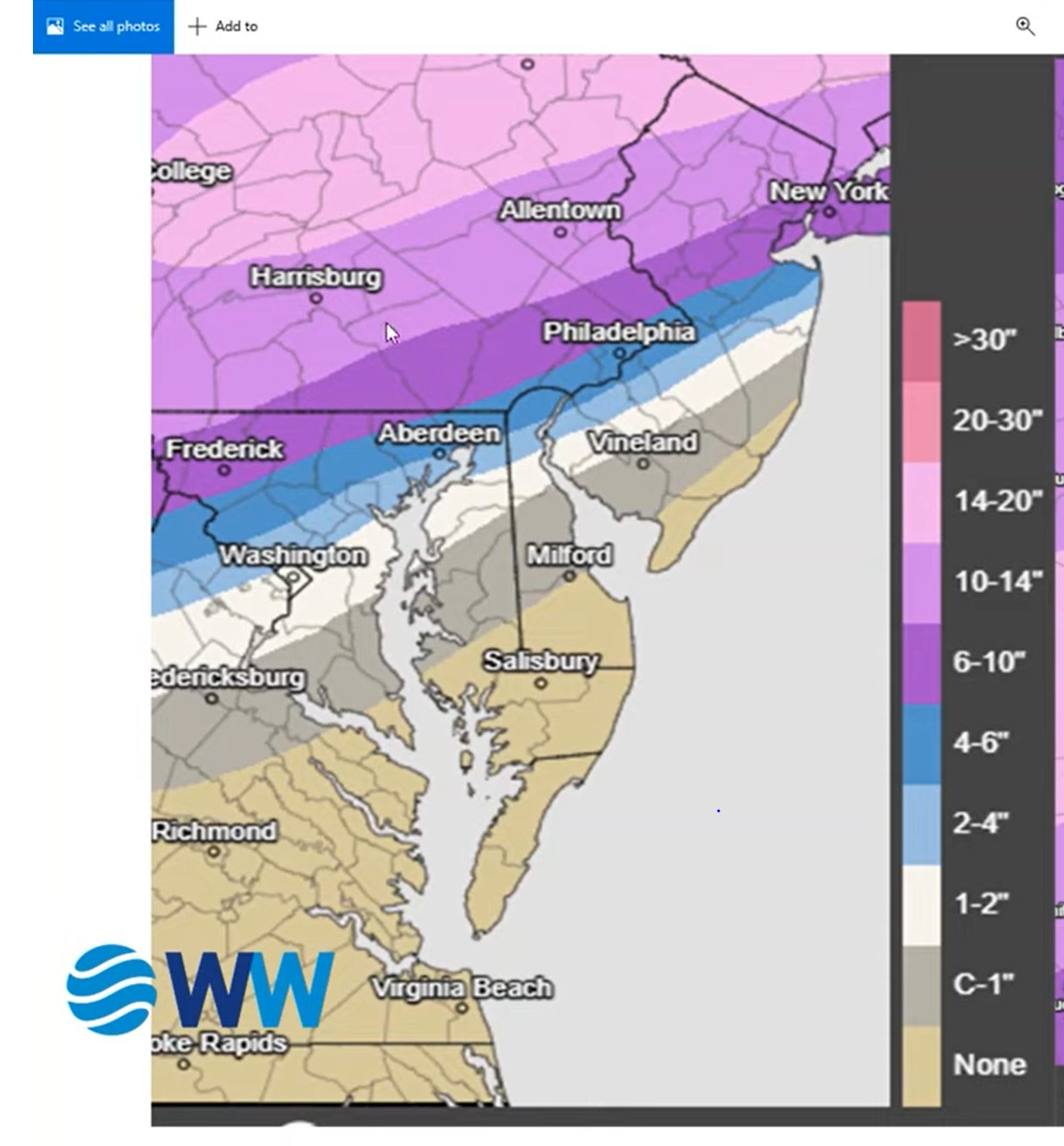
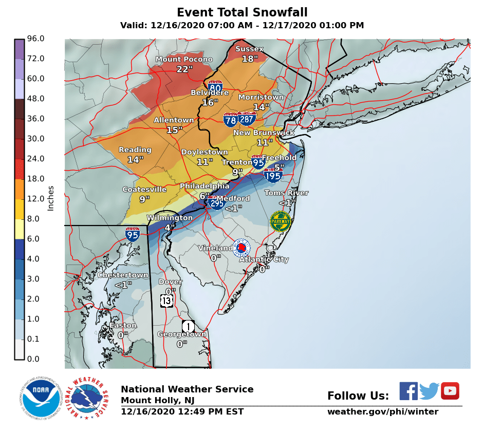
Summary: So, at 0Z we're not really that far off from where we were last night at this time, despite having gone through some model ups and downs during the day, so I'll stick with what I've been saying for 2 days now. If you live along or NW of the 95 corridor from Philly to NYC (and especially from Trenton to NYC) prepare for a major (8" or more) snowstorm, with 12" or more possible especially just NW of 95 and anywhere NW of there, starting around 1-3 pm for most and ending around or just after sunrise Thursday. Along and SE of 95 and towards the coast will likely be the battleground for snow/sleet/rain at times, with snowfall amounts decreasing fairly steeply from NW to SE with the immediate coast maybe only getting a few inches (and a lot of rain). And, of course, most of the area well NW of 95/N of 78 is just about a lock to get 12-18" (or more in spots). Enjoy, but stay safe.

Some Details: Also by early Thursday, after about 9 pm, the winds will increase to 30-40 mph gusts inland and 40-55 mph gusts along the coast, so we'll likely have at least occasional blizzard conditions from then through early Thursday, especially where it's snowing hard (some areas will be getting 2" per hour snowfall rates around then although near 95 there could be sleet some of that time). Where there's heavy wet snow and these winds, we'll likely see some power outages. Finally, the prolonged NE fetch will lead to moderate coastal flooding for the bays and the Atlantic coast.

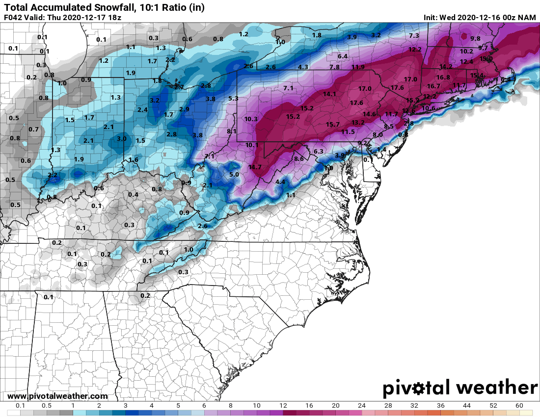
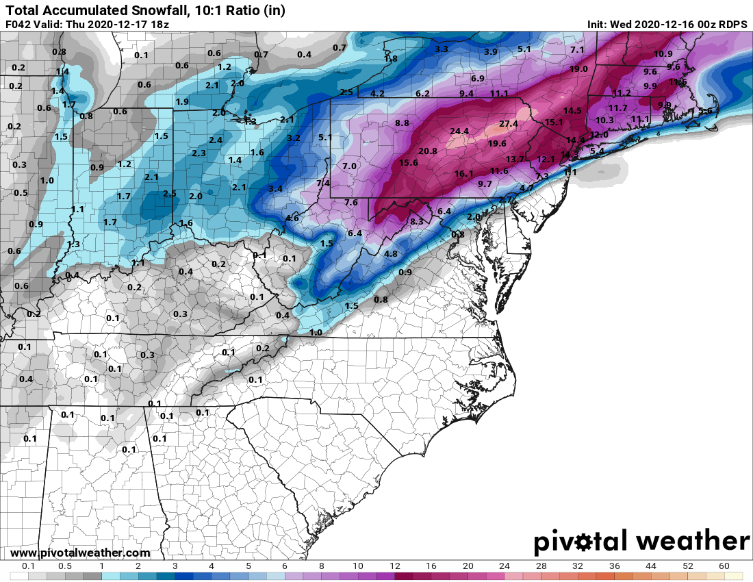
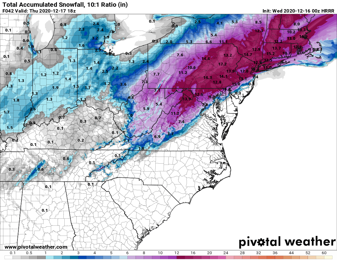
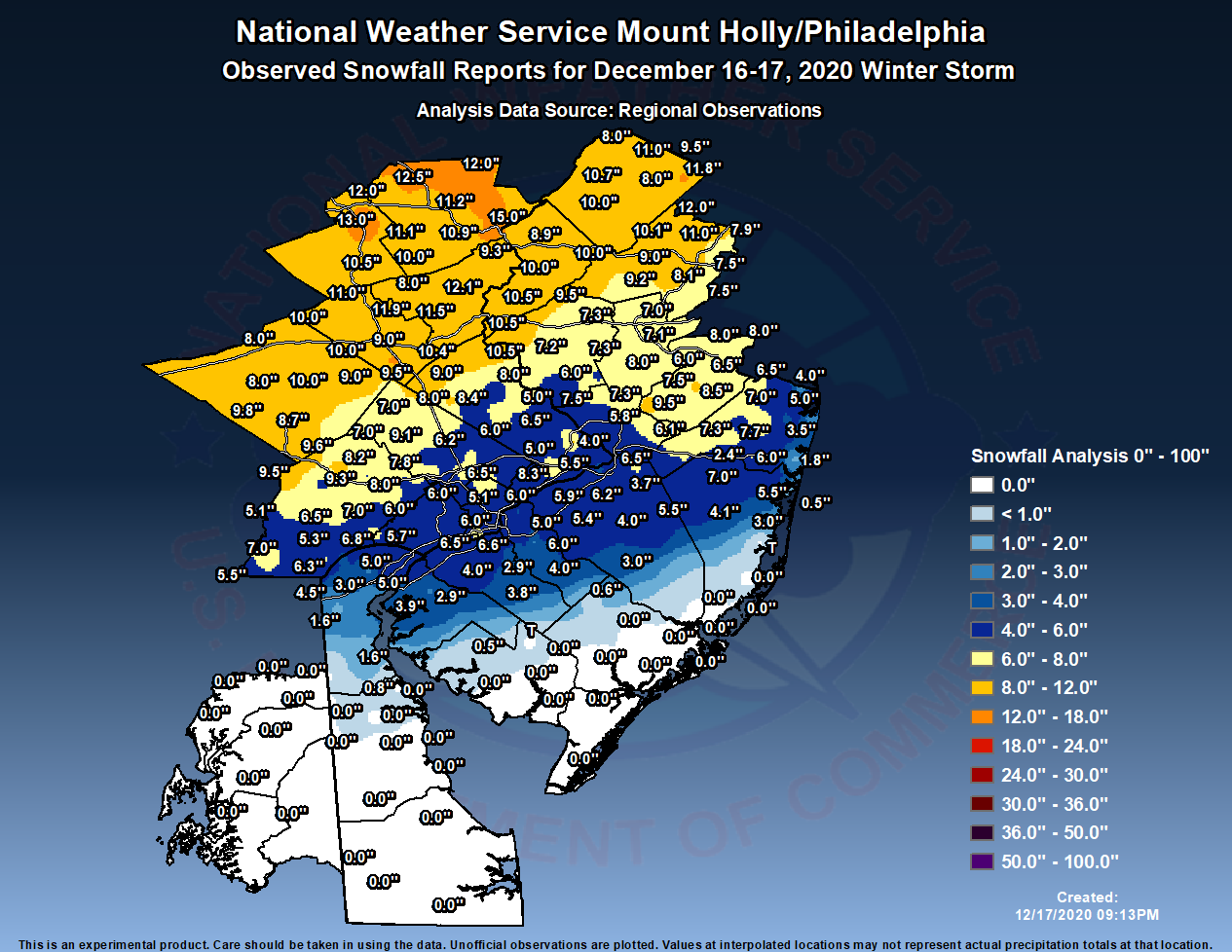
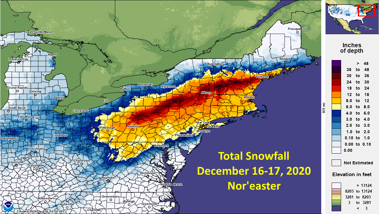
Let's take a look at the 0Z models (same 6 from last night + the HRRR mesoscale model, which is now more in range), mostly for completeness, since I've done this every night so far. No energy for commentary on all of them, but suffice it to say that some have more in spots than others and some have less, but they're far more similar than different and they all show a major (8" or more) of snow from Trenton to NYC and almost all show 8" or more from Philly to NYC. And they all have parts of the 95 corridor (generally from about NB to NYC) where snowfall is 12" or a bit more, but they also all show fairly sharp gradients from these amounts to just a few inches (if that) by the time one gets close to or reaches the NJ coast. On the flip side almost all of them show 12-18" well NW of 95 and certainly N of 78.

The two big wild cards remaining are how much sleet will we see, especially in the 95 corridor and just NW of there and how much total precip (these lead to the purple "holes" of less snow in the midst of the burgundy higher snowfall amounts on the maps), both of which are heavily influenced by the surface low track and the tracks or the upper level lows at 700 mbar and 850 mbar, as well as the strength of the cold air source in Quebec. Given that many of the sleet signatures I've seen from the column soundings are iffy, it's quite possible that dynamic cooling during heavy snowfall from above, combined with inability to warm the sub-15F flakes from above during a traverse of several hundred feet through 33F warm layer, will greatly reduce sleet, such that these areas will see more snow - we'll see. There are also factors that could lead to more sleet/rain.

Given that we're now just about 18 hours from the 7 pm EST data inputs to the 1 pm start time tomorrow, any major shifts in the models are unlikely, although it has happened once or twice before. As per earlier today, I think the adjusted downward NWS-Philly maps and the NWS-NYC maps are pretty good, as well as WxRisk's and several others. Getting close to nowcasting time and playing in the snow time.

https://www.weather.gov/phi/
https://www.33andrain.com/topic/1998-dec-16-18-possible-ec-snowstorm/page/279/
https://www.americanwx.com/bb/topic...nesday-noon-thursday-dec-16-17-2020/page/102/

NXvabtz.png


k12e4ZI.png
qsiPkOt.png


sHtNjJE.png


KvVhgFZ.png


y3wFOfw.png


tbPAcfk.png
 
  • Like
Reactions: RUJohnny
Give it up. Bac is right, it was a horrible forecast and major bust*. Also, as I said before, WW nailed it again. Almost perfect forecast by them.

*for certain localities

People are very quick to pull the bust trigger when their small patch of land doesn't fall within range. It's almost like complaining about a Vegas line because no points were scored in the second quarter, when the final score ended up being relatively close.
 
  • Like
Reactions: RU848789
This thread delivered better than most
  • Drama
  • Bad forecasts
  • Arguments over perceived bad vs good forecast
  • Cool pics
  • Model forecast image du jour
  • A ton of wishcasting
  • Intractability
Maybe chime in with something of substance in these threads once in awhile, since you certainly should be capable of it. Obviously Mt. Holly had some misses, but Upton did pretty well. What was your take on their forecasts?
 
This thread delivered better than most
  • Drama
  • Bad forecasts
  • Arguments over perceived bad vs good forecast
  • Cool pics
  • Model forecast image du jour
  • A ton of wishcasting
  • Intractability

...and you immediately jumping into the argument after the above reflection 😂
 
Give it up. Bac is right, it was a horrible forecast and major bust. Also, as I said before, WW nailed it again. Almost perfect forecast by them.
WW did great and generally better than the NWS, no doubt about it, but the difference between them and the NWS wasn't that large. For most it was a 2" difference on the various swaths, e.g., WW had 6-10" where the NWS had 8-12" and they had 4-6" where the NWS had 6-8" and so on and for well N/W, they had 10-14" where the NWS had 12-18". Being off by a couple of inches is a bust, but not a major bust, IMO.

ipUjPFz.png


tWAzmtE.png
 
Get a better snowblower...drop a hint to your significant other! 😉
I'm sure you know the old very sexist/politically incorrect (but funny) joke about this one, don't you? If not, it goes something like this. How do you convert a dishwasher to a snowblower for only twenty bucks? Buy her a shovel. And that's the semi-clean version of the joke. I'm guessing I'll get some hate mail for that one, lol.
 
Give it up. Bac is right, it was a horrible forecast and major bust. Also, as I said before, WW nailed it again. Almost perfect forecast by them.
Maybe where you live. Here are in Monroe, we got 5 or 6 inches which was spot on what was forecasted.
 
*for certain localities

People are very quick to pull the bust trigger when their small patch of land doesn't fall within range. It's almost like complaining about a Vegas line because no points were scored in the second quarter, when the final score ended up being relatively close.
All that matters is my location! 😜
But seriously, this forecast was off in many, many locations. Too much hype, not enough science.
 
  • Like
Reactions: goru1869
Yeah, was reading through the 33andrain thread and one of the mets said the 700 mbar low went through central PA, then just south of Binghamton and Albany and through MA, which is why many were postulating that the areas near and north of that got hammered so hard. Some also mentioned subsidence SE of that line being at least partly responsible for much of our area being either below or on the low end of snowfall forecasts (moreso than the sleet, which also didn't help).

Hard to predict that kind of banding - in fact, as I posted on 33, really only the CMC in the day or so leading up to the event got that banding even marginally right (post with models below), especially for VT/NH, which no other model came close on, plus the CMC got it right on its modeling of only 8-12" for 95 and even well into NNJ. But no mets can "know" that one is going to be right (especially when the CMC isn't usually, lol), which is why most go with model blends and some local knowledge and relying on some synoptic knowledge, like you and some others did on looking at the track being too close to the coast and the upper level lows going west likely leading to at least some sleet.
Can you link the discussion thread you are referring to?
 
S
If you want to be obstinate and whine about the warning statement being wrong, when you know they either have to include all or none of the county in that group, have at it - a better complaint would be to split the county in half (same for Middlesex) so they can account for the differences which often occur in these counties, like they've done for several other counties in NJ. But you know well enough to know that the map is the primary source for snow forecasts, since the map has the ability to show the finer details and you were in the 8-12" swath.

I still don't know why you get so angry at foreasts that are off a bit, when getting every location right is essentially impossible, given the chaotic nature of numerical modeling and the uncertainty inherent in such forecasts. Back in the 70s and 80s we were lucky to get snowstorms even marginally correct, so the improvements since then are huge. In the big picture, the models were superb in sniffing out a major snowstorm for the entire northeast nearly a week in advance and the forecasts from a day or so before the event across the area were the usual mix of great for some, pretty good for others and pretty bad for some, which is almost inevitable, as per my breakdown in the earlier post,

Nobody was going to predict 30"+ for a huge swath of PA/NY/VT/NH accurately and it turned out that them getting so much snow "robbed" much of our area of some of the snow we were forecast to get (via subsidence). It turns out that much of the NWS 95 corridor forecast of 8-12" was pretty good for NB to NYC, but not nearly as good SW of there to Trenton and in SE PA and certainly the areas NW of you and me predicted to get 12-18" were all short of that by a few inches for most (but there are reports of over 12" in those locations, too). In hindsight a "better" forecast would've been 6-10" for the 95 corridor and 8-14" for the next tier to the NW. They were off a bit - it happens.


Somerset County should never be grouped in with those counties in Pennsylvania. It makes no sense. And I would for the average person they dont look at maps. The may have weather app on their phone, the alert will say winter storm warning and they will click and read the text.
 
  • Like
Reactions: goru1869
Big bust if you go by the forecast 3 days out. The local news nailed it 24 hours out. 3-6 in the Philly local area. So happy I didn't shovel last night like my neighbor. We had sleet, rain and back to snow. His sidewalks are thick ice skating rinks! Mine all the frozen on top, soft snow below.
Hmmm - not quite the case for central Jersey: NWS Mount Holly had us at 12” before and then dropped to 11” during the storm... and we got... ~5”. That’s a pretty big miss in my book!
 
WW did great and generally better than the NWS, no doubt about it, but the difference between them and the NWS wasn't that large. For most it was a 2" difference on the various swaths, e.g., WW had 6-10" where the NWS had 8-12" and they had 4-6" where the NWS had 6-8" and so on and for well N/W, they had 10-14" where the NWS had 12-18". Being off by a couple of inches is a bust, but not a major bust, IMO.

ipUjPFz.png


tWAzmtE.png
And here's the reported snowfall map from the NWS-Philly, showing how well WW did and how the NWS was over by a few inches along 95 and NW of there - a bust, but not a huge bust. And if mets ever start being a little smarter and factor in frozen mass (as that's what matters from a driving/snow removal perspective), the NWS would've been close to spot on, as most locations reported depths that were about 2" less than they would've been if the ~1" or so of sleet most got had been snow (1" of sleet is 3.3" of typical snow). It's also interesting that you (T2K) and bac reported significantly less snow than everyone around you. Hmmmm...

Edit: adding in the NWS Eastern Region snowfall map an impressively large area of 6"+ snowfall - one of the largest in many years - and an incredible area of 24"+ snows in PA/NY/VT/NH/ME.

fvd9Fsh.png


Ql1XpGa.png
 
Last edited:
Can you link the discussion thread you are referring to?

Here's the thread, but it's hundreds of pages long. I don't recall who made the comment, but if you search for "Albany" in it, you'll probably get a hit, as I think he mentioned Albany (and only a few posts would've mentioned Albany). Busy now, but if I have time later, I'll look...

https://www.33andrain.com/topic/199...-thread/page/406/?tab=comments#comment-237317

Edit: @RUJohnny - it took literally 5 seconds to find - would've been faster to find it than to describe how to find it, lol..

https://www.33andrain.com/topic/199...s-model-thread/?do=findComment&comment=237255
 
Last edited:
  • Like
Reactions: RUJohnny
And here's the reported snowfall map from the NWS-Philly, showing how well WW did and how the NWS was over by a few inches along 95 and NW of there - a bust, but not a huge bust. And if mets ever start being a little smarter and factor in frozen mass (as that's what matters from a driving/snow removal perspective), the NWS would've been close to spot on, as most locations reported depths that were about 2" less than they would've been if the ~1" or so of sleet most got had been snow (1" of sleet is 3.3" of typical snow). It's also interesting that you (T2K) and bac reported significantly less snow than everyone around you. Hmmmm...

fvd9Fsh.png
NWS =

uptonXXX.jpg
 
S


Somerset County should never be grouped in with those counties in Pennsylvania. It makes no sense. And I would for the average person they dont look at maps. The may have weather app on their phone, the alert will say winter storm warning and they will click and read the text.

Actually, for their forecast it made perfect sense. They thought there was very little chance of sleet mixing in north of the 12" line, which included a bit more than half of Somerset and well more than half of W. Montco, Upper Bucks and Hunterdon and all of every county NW of those. So they grouped them together. Like I said before, if they split the county in half, like they've done for Montco, Bucks, Burlington, Passaic, Union, Essex, Chester, and more, they could've put northern Somerset in with the 12-18" counties and southern Somerset in with the 8-12" counties.
 
Its never appropriate..theyve been doing to for far too long..at least half the county has more in common with Middlesex..not bumblebee PA
 
Could be some snow showers tomorrow - maybe a coating to 1/2" on grass/colder surfaces with temps a few degrees above 32F - more mood flakes than anything else
 
Last edited:
I see alot of snow totals within towns. Metuchen has 6.5 to 3.9 Somerville 8 to 5.4 Manville 8 then Hillsborough next town over 6. Why the difference within?
 
I see alot of snow totals within towns. Metuchen has 6.5 to 3.9 Somerville 8 to 5.4 Manville 8 then Hillsborough next town over 6. Why the difference within?
Official Monty totals (via DPW):
Belle Mead = 5.5
Skillman = 6.0
 
Not to hijack the thread but any one uses an electric 2 stage snow blower?
 
I see alot of snow totals within towns. Metuchen has 6.5 to 3.9 Somerville 8 to 5.4 Manville 8 then Hillsborough next town over 6. Why the difference within?
A combination of when the report came in and probably poor measurement technique. The 3.9" report in Metuchen was from 7:20 pm, which was way before the storm was over - I mentioned this earlier and have no idea why the NWS leaves those reports in there after the storm is over. The 6.5" report was from 7:45 am, but we got about 1/2-3/4" of snow after that from one last band, so that one should've been 7.0-7.25".

It's possible we actually had a 1" diffference across Metuchen, as I had 8.25", but I think it's more likely the other person didn't use the best technique. One is supposed to use a snow board and clear the board every 6 hours, summing all the 6-hour accumulations, in order to avoid excessive compaction, especially in a heavy snowfall or one with phase changes. I cleared mine around 9 pm (with 5.75" having fallen), which was right before we had mostly sleet for a few hours, which usually compacts the snow and we had about 1/2" of sleet and 2" of snow after that for 8.25". However, in locations around the yard, we had about 7.5", as it was likely the sleet, which is denser than snow, helped compact the underlying snow - that's much closer to what the other person would've had if they had added in the last 1/2-3/4". And my 8.25" is in line with trained spotter reports nearby, which were generally 7.5-8.5", plus a met in Metuchen reported 8.0" on one of the weather boards.

For Somerville, the 8.0" and 5.4" reports were at the same time, so I then look to see if there are nearby reports and there are two from Bridgewater which were 7.5" and 7.1" and one from Manville, which was 8.0". Hence, I'd tend to discount the 5.4" report. For this storm, measurement variations were likely higher, due to drifting - we had some 12-18" drifts and some areas with only 1-2" of snow. That's why the other thing I do is to measure a dozen or more spots around the yard (not on the board), just as a check to see if my reported measurement is possibly high or low (it wasn't).
 
Not to hijack the thread but any one uses an electric 2 stage snow blower?

When I google electric 2 stage snow blowers, I get electric start blowers that use gas as their fuel. I had one, and the electric start worked great. There used to be something called an electric shovel, but it didn't have much power. If there really are blowers that work on electricity that would be great, particularly if they're battery-powered. I hate dealing with gasoline or having it in my house.
 
Not to hijack the thread but any one uses an electric 2 stage snow blower?

Based on your earlier post, you have a long driveway. Don’t get anything with a cord - they are a huge hassle to deal with if you have a lot of area to clear.
 
I need a 2 stage blower because my 1 stage toro just can’t do the job if it’s over 6” and heavy or 9” dry. There are limited option for electric 2 stage. EGO makes one. Just wondering if anyone has one and can share their experience? I like the electric because of low maintenance (no oil change). Thanks all.
 
Mt. Holly WFO has really struggled this past decade overall with counties south of I-78 and I’m not sure why. They always seem to have a solution that flies in the face of general model guidance and local climo.

For my location in Somerset, we’ve been projected to get a foot or more (projected being 12-18, 12-20, etc) 7 times since 2012 when the first flakes started flying and we’ve only verfied once (2016).

I know a lot of you use 33andrain, personally I’m part of the wxdisco community (emerged from old accuweather boards) and we always end up with a concensus much more accurate than Mt. Holly. In our most recent storm the issue was their mindboggling insistence that there would be zero mixing and/or dryslot south of 78 in both PA and NJ when model concensus had suggested that for 48 hours up to that point.
 
Heard there is supposed to be crazy wind and rain tonight. Make sure them inflatables are staked good.
 
Man the snow melted fast since last night. When I looked out back mid-morning, most of the snow in the woods was gone.
 
  • Like
Reactions: Postman_1
ADVERTISEMENT
ADVERTISEMENT