Impressive. What about the snow?9” on my driveway in Summit


Colleges
- AAC
- ACC
- Big 12
- Big East
- Big Ten
- Pac-12
- SEC
- Atlantic 10
- Conference USA
- Independents
- Junior College
- Mountain West
- Sun Belt
- MAC
- More
- Navy
- UAB
- Tulsa
- UTSA
- Charlotte
- Florida Atlantic
- Temple
- Rice
- East Carolina
- USF
- SMU
- North Texas
- Tulane
- Memphis
- Miami
- Louisville
- Virginia
- Syracuse
- Wake Forest
- Duke
- Boston College
- Virginia Tech
- Georgia Tech
- Pittsburgh
- North Carolina
- North Carolina State
- Clemson
- Florida State
- Cincinnati
- BYU
- Houston
- Iowa State
- Kansas State
- Kansas
- Texas
- Oklahoma State
- TCU
- Texas Tech
- Baylor
- Oklahoma
- UCF
- West Virginia
- Wisconsin
- Penn State
- Ohio State
- Purdue
- Minnesota
- Iowa
- Nebraska
- Illinois
- Indiana
- Rutgers
- Michigan State
- Maryland
- Michigan
- Northwestern
- Arizona State
- Oregon State
- UCLA
- Colorado
- Stanford
- Oregon
- Arizona
- California
- Washington
- USC
- Utah
- Washington State
- Texas A&M
- Auburn
- Mississippi State
- Kentucky
- South Carolina
- Arkansas
- Florida
- Missouri
- Ole Miss
- Alabama
- LSU
- Georgia
- Vanderbilt
- Tennessee
- Louisiana Tech
- New Mexico State
- Middle Tennessee
- Western Kentucky
- UTEP
- Florida International University
High School
- West
- Midwest
- Northeast
- Southeast
- Other
- Alaska
- Arizona
- California
- Colorado
- Nevada
- New Mexico
- Northern California
- Oregon
- Southern California Preps
- Washington
- Edgy Tim
- Indiana
- Kansas
- Nebraska
- Iowa
- Michigan
- Minnesota
- Missouri
- Oklahoma Varsity
- Texas Basketball
- Texas
- Wisconsin
- Delaware
- Maryland
- New Jersey Basketball
- New Jersey
- New York City Basketball
- Ohio
- Pennsylvania
- Greater Cincinnati
- Virginia
- West Virginia Preps
ADVERTISEMENT
Install the app
How to install the app on iOS
Follow along with the video below to see how to install our site as a web app on your home screen.
Note: This feature may not be available in some browsers.
You are using an out of date browser. It may not display this or other websites correctly.
You should upgrade or use an alternative browser.
You should upgrade or use an alternative browser.
OT: 12/16/20 Snowstorm Thread: First Significant Winter Storm of the Season - Major Snow/Sleet/Rain
- Thread starter RU848789
- Start date

So after finishing up poker around 1 am, I went out and shoveled while it was snowing mostly lightly (had sleet before then) and finished around 3 am. We got about another 1" from 11-3 for a probable final tally of 7.0", which matches up well with the 6.5-7.5" amounts I've seen in northern Middlesex County; we did get 12-16" drifts, lol. Not quite the 8-12" range I was thinking for the 95 corridor, but not that far off either. Was certainly a fun storm to track and enjoy. I had cleared the board at 11 pm and we got about 1/2" of sleet and a 1/2" of snow, which would've been about 2" if all snow (which would've been 8" total). Yeah a foot would've been nice, but I got almost as much as all last winter, so i'm pretty happy.
Was interesting to see how many of the areas predicted to get maybe 1-3/2-4", like much of SNJ near Philly (which got 6.3") and northern Ocean and much of Monmouth County ended up getting 4-7", so those areas overperformed while the 95 corridor underperformed a fair amount vs. the NWS forecasts, but weren't too bad vs. the 6-12" forecasts many had and I'm pretty sure @RUJohnny and the WW folks got it pretty close (can't recall, but I think they both said 4-8").
And the areas NW of 95 and well NW that were forecast to get 12-18" (and up to 20" in spots) busted pretty badly as I've only seen a few reports over 10" with only the Poconos getting over 12". The 8-14" for NYC/LI busted moderately, as they mostly got 4-8" with Central Park getting 6.5", more than last winter. Turns out that it wasn't really the sleet that got us nearly as much as simply not getting the precip, as very few locations got over 1" liquid, when 1.5" or more was expected. The areas that got all the precip were huge swaths of central/northern PA and much of NY from Binghamton to Albany, where many locations got over 20" of snow (and some places got 30").
Some folks may still pick up another inch or so (we're getting some light snow still). And yes, my back is killng me, lol - this is why I usually shovel every 3-4" and not all at once...
Well, we got 1.25" more overnight to bring my total to 8.25", which is (barely) in line with my 8-12" prediction for the 95 corridor from Philly to NYC, but especially for Trenton to NYC (been saying that since Monday afternoon). I had cleared the board and shoveled and there was about 1.25" inch or so in both locations, plus I woke up a few times and it was still snowing, including a really nice surprise 20 minute heavy band about an hour ago that probably put down 1/2" of that. Locally, Perth Amboy reported 9" and many other locations in Middlesex County reporting 7-9". Have even seen reports of 6-8" in northern Monmouth, which really overperformed.
Many places in NE NJ/NYC got 2-3" more overnight, with Central Park up to 10" and many other locations in NYC in the 8-11" range, so their 8-14" forecast looks like it actually verified for some (but not for the folks within 1-2 miles of the ocean in Brooklyn/Queens - looks like 5-8" for them). Quite a few reports of 8-10" in Hudson/Essex counties also (Elilzabeth, Harrison, and more). So, when looking at the public reports from the NWS, they're likely incomplete if they were from before 1 am.
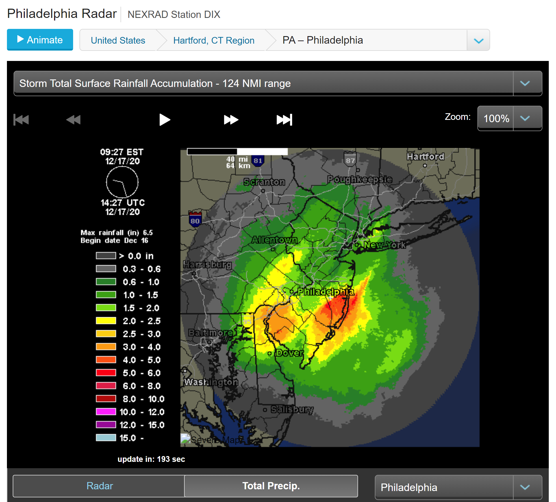
Thought this was a cool graphic, below, showing the storm total precip - puts me in the 1.0-1.5" range, which makes sense, given the sleet for a few hours (lost 1-2" due to that - probably would've had 9-10" without the sleet). Look at the coast - could've been a giant blizzard there with a track further offshore and a little more cold air.
Edit: Newark Airport reporting 11", the Bronx with 12.6", Elizabeth with 9.1", LaGuardia with 9", JFK with 6.2" (close to the coast, so a lot more sleet) and Philly with a final tally of 6.6". I think we're going to see a lot more reports in the 8-12" range for Middlesex and NE NJ (Union/Hudson/Essex/Bergen/Passaic), given the snow that fell over night.
Last edited:
Had 4-5" in the driveway when I cleared last night around 10. Extra 3-4" of heavy sleet laden cover this morning when the sun came out. Let than expected, but not far from the 8-12" predicted.
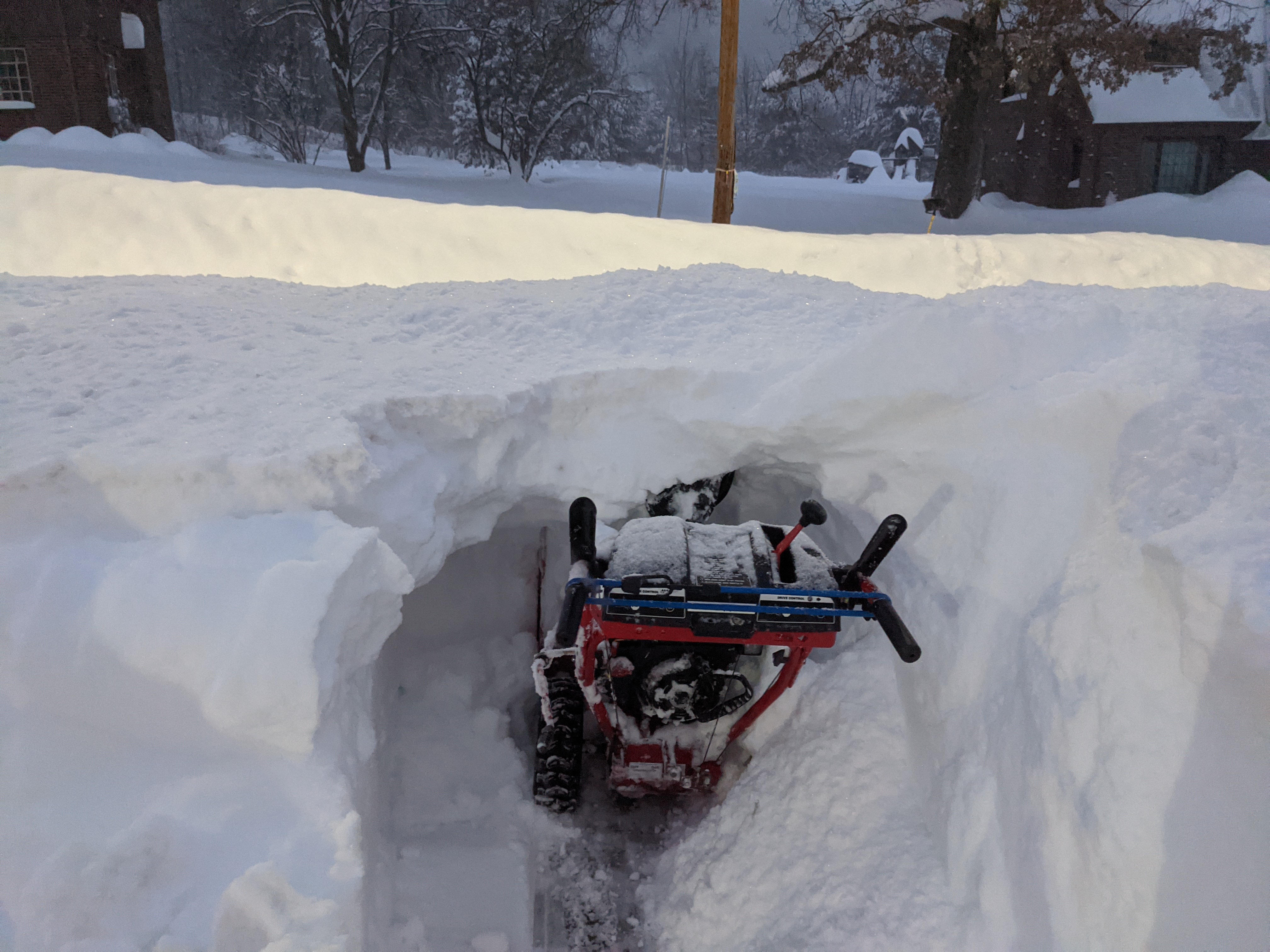
My friend up in Binghamton just sent me a shot of his snowblower, he's got over 3 feet and his snowblower only has a 20" cut.
A
anon_ivydyf0amkzay
Guest
I live north of Boston near the New Hampshire line--we have about 16 inches of snow and it's still coming down hard......... temperature is 20 degrees
thats what I used to call a soul-crusher 😩My friend up in Binghamton just sent me a shot of his snowblower, he's got over 3 feet and his snowblower only has a 20" cut.
He needs a better snowblowerMy friend up in Binghamton just sent me a shot of his snowblower, he's got over 3 feet and his snowblower only has a 20" cut.
+1 - overhyped, underperformed.Busty bust
That's what she said...+1 - overhyped, underperformed.
41 freakin' inches!My friend up in Binghamton just sent me a shot of his snowblower, he's got over 3 feet and his snowblower only has a 20" cut.

Big bust if you go by the forecast 3 days out. The local news nailed it 24 hours out. 3-6 in the Philly local area. So happy I didn't shovel last night like my neighbor. We had sleet, rain and back to snow. His sidewalks are thick ice skating rinks! Mine all the frozen on top, soft snow below.+1 - overhyped, underperformed.
Actually still snowing here. With sun out lol. Light snow. Had a decent snowfall here. Maybe I'll measure a little later
930am in Sayreville it was still accumulating, figured we got about 8"Still snowing lightly in Holmdel.
For some locations, not others - was a mixed bag. With the 2-4" overnight for many in Hudson/NYC/LI, it looks like the 8-14" NWS-NYC forecast will verify nicely, given the following reports: Bronx with 12.6", CPK with 10", EWR with 11", Harrison with 9.7", and LGA with 9.2" (and plenty of 7-10" reports on LI). For Union, Essex, Bergen and Passaic, which had a 12-17" forecast, it was a mild bust with most reports this morning in the 8-12" range (EWR with 11", Elizabeth with 9" and some others), given the overnight snow.Busty bust
And yes, the NWS-Philly went way too high too early, as we discussed, but their pre-storm 6-8" for Philly verified and their 3-6" for areas in SNJ not far from the Delaware, plus their 8-12" for most of Chester-Montco-Bucks-Mercer-Somerset was only a bit overdone (most got 5-8").. And I'd say their 8-12" call for Middlesex was pretty close at least for the northern half with most reports of 7-9".
Where the NWS busted more badly was in the 12-18" forecast areas like most of Hunterdon, northern Somerset, Warren, and Morris, where relevant reports (reports before midnight are irrelevant as more snow fell) look to be in the 7-10" range. For the Lehigh Valley and Sussex, it was a mild bust with reports of 8-14" vs. the 12-18" forecast and for the Poconos the 10-15" snowfalls were well below the 18-24" forecasts.
Also, pretty cool radar loop here - really shows the overnight snows well. Those overnight snows got quite a few locations up into the NWS forecast ranges, as discussed above (and me, too, with my 1.25" overnight to get to 8.25").
Last edited:
What I don't understand is how East/NENJ/NYC had less sleet than Somerset, Hunterdon, and Morris counties despite their closer proximity to the coast. The WAA was rotating in off the warm ocean waters so how did it jump over the coastal regions and settle in more interior areas?
I'd say we got about 4" in Hamilton. Just got done shoveling and snowblowing. The shoveling part sucked because it was mixed with sleet. Ended up snowblowing about 3 neighbors houses. Did my neighbor across the street and the extension cord got wrapped up in the snowblower. No good deed goes unpunished I guess. Hopefully she has another.
I had a winter storm warning in my area which text of the alert said 12-20 inches.
I got 5.5...its a mammoth bust
I got 5.5...its a mammoth bust
He needs a better snowblower
Or snowblow twice. First one in the middle of the storm.
A
anon_ivydyf0amkzay
Guest
This...why people wait to do it all at once is puzzling...unless you have teens and can direct them to do it all...then who cares!Or snowblow twice. First one in the middle of the storm.
Looks like he’s building himself a nice little snow fort at the end of his driveway. That way, he can make snowballs and hide out, waiting for people to walk by in the road, so he can nail ‘em in the back of the head, then duck down out of sight, stifling his evil giggles.My friend up in Binghamton just sent me a shot of his snowblower, he's got over 3 feet and his snowblower only has a 20" cut.
I personally would never do such a thing, being the deeply respectful and mature person I am. But that’s what I imagine they do for fun in upstate NY.
A
anon_ivydyf0amkzay
Guest
Loooooong, dark and cold winter ahead for those folks! 😱Looks like he’s building himself a nice little snow fort at the end of his driveway. That way, he can make snowballs and hide out, waiting for people to walk by in the road, so he can nail ‘em in the back of the head, then duck down out of sight, stifling his evil giggles.
I personally would never do such a thing, being the deeply respectful and mature person I am. But that’s what I imagine they do for fun in upstate NY.
I learned that lesson long ago. Unless it starts out with ice/sleet, let it all come down so that the ice/sleet is just a crust over the snow. Way easier to clear away, as opposed to having to chip away at a hardened shell of ice on paved surfaces or decks/porches.So happy I didn't shovel last night like my neighbor. We had sleet, rain and back to snow. His sidewalks are thick ice skating rinks! Mine all the frozen on top, soft snow below.
Bust locally for Hillsborough, which I'm happy about. Overall across the region, the storm seem to have performed about as expected (underperforming in some areas, overperforming in others), but thankfully fell short in my backyard.
23 pages for 6 inches of snow?! Must be some kind of board record.
Well i always say its pretty worthless before 72 hours out
One more page and we would have the same number of pages that some people predicted we would get in snow totals in parts of NJ. How much snow did you get under your bed ?23 pages for 6 inches of snow?! Must be some kind of board record.
+1I had a winter storm warning in my area which text of the alert said 12-20 inches.
I got 5.5...its a mammoth bust
MEGA BUST! Again.
You will have to put it in the fine print that in the event of mixed precipitation, pricing will be based on the snow equivalent of the fallen sleet and freezing rain using the standard 10:1 snow:liquid ratio.I wonder if I told the owners of my commercial lots that we were going to get over a foot like someone on here if I still can charge them for clearing 1 foot even if we only got 5 inches.? lolololol
One more page and we would have the same number of pages that some people predicted we would get in snow totals in parts of NJ. How much snow did you get under your bed ?
I think we'll get to that 4:1 ratio.
Not much inside beyond what came in on the dog. But been snowing all week and supposed to continue tonight.
Bring it on, good start to ski season.
Got out this morning to clear a very dense 4-5 inches off the driveway after hearing what sounded like a hailstorm against the windows for a couple of hours last night. Wind was crazy, too, but thankfully only blew off a couple of small Christmas decorations (and thankfully not the big new wreath we put up this year). Had that been snow and not ice pellets, might have been more depth here at the foot of Sourland Mountain, but plenty enough for sledding for the kids this morning.
You wonder why many are skeptical of weather forecasts! Roll eyes. I also enjoy how doubling the forecast is considered accurate. 6 to 12 inches, 12 to 24 inches? Comical!
Every snowfall map since Tuesday morning has had your area of southern Somerset in their 8-12" band (all posted in this thread), so 5.5" is still a bust, but not a mammoth one. And the zone text product for Somerset from their 4 am Weds morning package is below and it says 10-14", but there are notoriously incomplete, which is why 99% of the world uses the snowfall map.I had a winter storm warning in my area which text of the alert said 12-20 inches.
I got 5.5...its a mammoth bust
https://www.wrh.noaa.gov/total_forecast/getprod.php?afos=xxxzfpphi&wfo=phi&font=120&new=1&version=27
NJZ010-162100-
Somerset-
Including the city of Somerville
347 AM EST Wed Dec 16 2020
...WINTER STORM WARNING IN EFFECT FROM NOON TODAY TO 10 AM EST
THURSDAY...
.TODAY...A slight chance of snow this morning, then snow this
afternoon. Snow accumulation of 1 to 3 inches. Highs in the lower
30s. Northeast winds 10 to 15 mph with gusts up to 25 mph. Chance
of snow near 100 percent.
.TONIGHT...Snow. Isolated thunderstorms. Snow may be heavy at
times. Additional snow accumulation of 8 to 12 inches. Windy.
Near steady temperature in the upper 20s. Northeast winds 15 to
25 mph with gusts up to 35 mph. Chance of snow near 100 percent.
.THURSDAY...Mostly cloudy with snow likely in the morning, then
partly sunny in the afternoon. Total snow accumulation of 10 to
14 inches possible. Brisk with highs in the lower 30s. North
winds 15 to 20 mph, diminishing to 5 to 10 mph in the afternoon.
Chance of snow 70 percent.
That's not accurate. The WAA between 700 and 800mb was surging up the coastal plain. The H7 circulation center was way out by Harrisburg when parts of NJ flipped to sleet.What I don't understand is how East/NENJ/NYC had less sleet than Somerset, Hunterdon, and Morris counties despite their closer proximity to the coast. The WAA was rotating in off the warm ocean waters so how did it jump over the coastal regions and settle in more interior areas?
He needed to come out of the locker room at half timeHe needs a better snowblower
Similar threads
- Replies
- 62
- Views
- 2K
- Replies
- 608
- Views
- 17K
- Replies
- 771
- Views
- 20K
- Replies
- 477
- Views
- 12K
- Replies
- 80
- Views
- 2K
ADVERTISEMENT
ADVERTISEMENT