

Colleges
- American Athletic
- Atlantic Coast
- Big 12
- Big East
- Big Ten
- Colonial
- Conference USA
- Independents (FBS)
- Junior College
- Mountain West
- Northeast
- Pac-12
- Patriot League
- Pioneer League
- Southeastern
- Sun Belt
- Army
- Charlotte
- East Carolina
- Florida Atlantic
- Memphis
- Navy
- North Texas
- Rice
- South Florida
- Temple
- Tulane
- Tulsa
- UAB
- UTSA
- Boston College
- California
- Clemson
- Duke
- Florida State
- Georgia Tech
- Louisville
- Miami (FL)
- North Carolina
- North Carolina State
- Pittsburgh
- Southern Methodist
- Stanford
- Syracuse
- Virginia
- Virginia Tech
- Wake Forest
- Arizona
- Arizona State
- Baylor
- Brigham Young
- Cincinnati
- Colorado
- Houston
- Iowa State
- Kansas
- Kansas State
- Oklahoma State
- TCU
- Texas Tech
- UCF
- Utah
- West Virginia
- Illinois
- Indiana
- Iowa
- Maryland
- Michigan
- Michigan State
- Minnesota
- Nebraska
- Northwestern
- Ohio State
- Oregon
- Penn State
- Purdue
- Rutgers
- UCLA
- USC
- Washington
- Wisconsin
High School
- Illinois HS Sports
- Indiana HS Sports
- Iowa HS Sports
- Kansas HS Sports
- Michigan HS Sports
- Minnesota HS Sports
- Missouri HS Sports
- Nebraska HS Sports
- Oklahoma HS Sports
- Texas HS Hoops
- Texas HS Sports
- Wisconsin HS Sports
- Cincinnati HS Sports
- Delaware
- Maryland HS Sports
- New Jersey HS Hoops
- New Jersey HS Sports
- NYC HS Hoops
- Ohio HS Sports
- Pennsylvania HS Sports
- Virginia HS Sports
- West Virginia HS Sports
ADVERTISEMENT
Install the app
How to install the app on iOS
Follow along with the video below to see how to install our site as a web app on your home screen.
Note: This feature may not be available in some browsers.
You are using an out of date browser. It may not display this or other websites correctly.
You should upgrade or use an alternative browser.
You should upgrade or use an alternative browser.
OT: Another Minor/Moderate,Snow Event on Friday (1/19); Still Some Uncertainty
- Thread starter RU848789
- Start date

FWIW, the NWS disagrees completely as they don't have appreciable mixing/rain until one gets down to about Seaside on the barrier island only (2-4") and then a bit less on LBI (1-3") and even there, if one goes inland a few miles to Manahawkin, they're still predicting 4-6". Nobody west of the Parkway is forecast to get appreciable rain until south of about Tuckerton. Hard to say who's right as this will be a situation right on the knife's edge...Dan Zarrow on 107.1 the boss says "the coast" will get mixing and closer to 1". Blow some of that warm coastal air West towards us over here. I'm going to fill the 5 gallon tank in a bit.
the nws also claimed it wasnt going to rain or mix for the tuesday stormFWIW, the NWS disagrees completely as they don't have appreciable mixing/rain until one gets down to about Seaside on the barrier island only (2-4") and then a bit less on LBI (1-3") and even there, if one goes inland a few miles to Manahawkin, they're still predicting 4-6". Nobody west of the Parkway is forecast to get appreciable rain until south of about Tuckerton. Hard to say who's right as this will be a situation right on the knife's edge...
What a bunch of sissies.State offices closed tomorrow
maybe you can inject bleach...the made up phrase they saidTried that--could not get the electrons into the carburetor. Working on a new invention.
Whew boy, I am right on the edge of 4-6 and one of those 6-8 bands.
Zarrow seemed to be hedging, and their broadcast area is LBI up into Monmouth County- he was not too precise. Don't even know if he is a "real" meteorologist like Amy Freeze. 😜FWIW, the NWS disagrees completely as they don't have appreciable mixing/rain until one gets down to about Seaside on the barrier island only (2-4") and then a bit less on LBI (1-3") and even there, if one goes inland a few miles to Manahawkin, they're still predicting 4-6". Nobody west of the Parkway is forecast to get appreciable rain until south of about Tuckerton. Hard to say who's right as this will be a situation right on the knife's edge...
maybe you can inject bleach...the made up phrase they said
LOL at how defensive you guys got over that.
Dare I ask, where will you be tomorrow during this weather event? And don’t give me “searching for large breast gifs to needle numbers.” 😎What a bunch of sissies.
@Knightshift...are you named after the Quarterflash early 80s jam Night Shift?maybe you can inject bleach...the made up phrase they said
In the fetal position and working from homeDare I ask, where will you be tomorrow during this weather event? And don’t give me “searching for large breast gifs to needle numbers.” 😎
After taking the little one to school, I will be heading to the office.....to search for gifs of large busts for this thread!Dare I ask, where will you be tomorrow during this weather event? And don’t give me “searching for large breast gifs to needle numbers.” 😎
Home office!After taking the little one to school, I will be heading to the office.....to search for gifs of large busts for this thread!
There you go. But a tough forecast to nail. There’s going to be criticism either way.NWS changed from advisory to winter storm warning for Pway
I had you pegged as a battery powered snowblower guy. They aren't terrible; my neighbor has one. I was surprised how noisy they still are.Tried that--could not get the electrons into the carburetor. Working on a new invention.
Hamilton (Mercer County) just closed theirs too.Piscataway schools closed
Wild to see all these closings. Newark seems to be forecasted to get next to nothing. This line will be very pronounced.
and I am here for it...just to let ya knowThere you go. But a tough forecast to nail. There’s going to be criticism either way.
I wouldn’t expect anything less from you. 😂and I am here for it...just to let ya know
RFH didn’t close yet for some reason.Fair haven closed their schools tomorrow. Kids home allllll day.
So confused by all these closings. Mt Holly WFO is a running joke in met circles, this is the most bizarre forecast they have ever put out.
This is a 1-3” event north of the Turnpike.
This is a 1-3” event north of the Turnpike.
Maybe less.So confused by all these closings. Mt Holly WFO is a running joke in met circles, this is the most bizarre forecast they have ever put out.
This is a 1-3” event north of the Turnpike.
State offices closed tomorrow
Dear god, for this lightweight storm?
What a bunch of sissies.
Bingo!
Dare I ask, where will you be tomorrow during this weather event? And don’t give me “searching for large breast gifs to needle numbers.” 😎
Ummmmmmmm.....................I'm truly trying to figure out what is wrong with that.
@Knightshift...are you named after the Quarterflash early 80s jam Night Shift?
Or perhaps this one by the Commodores?
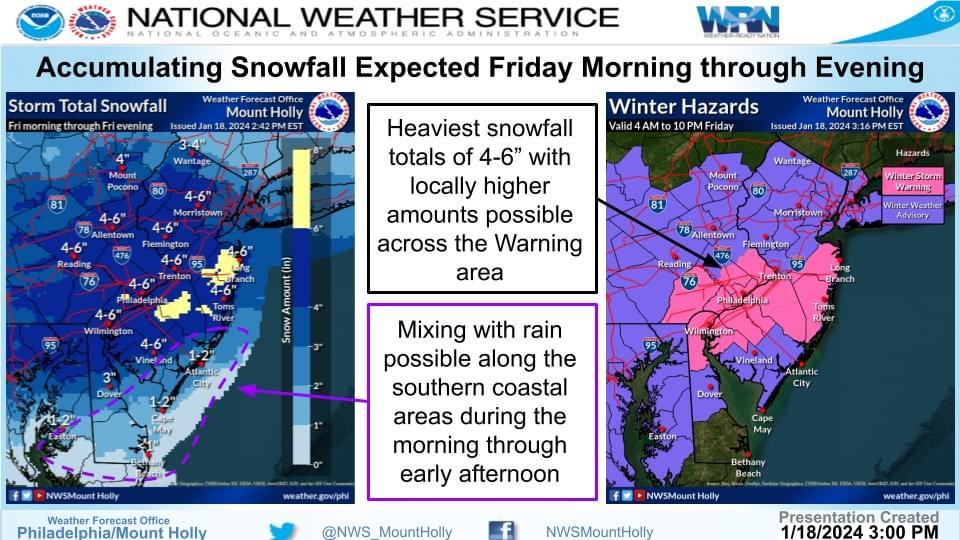
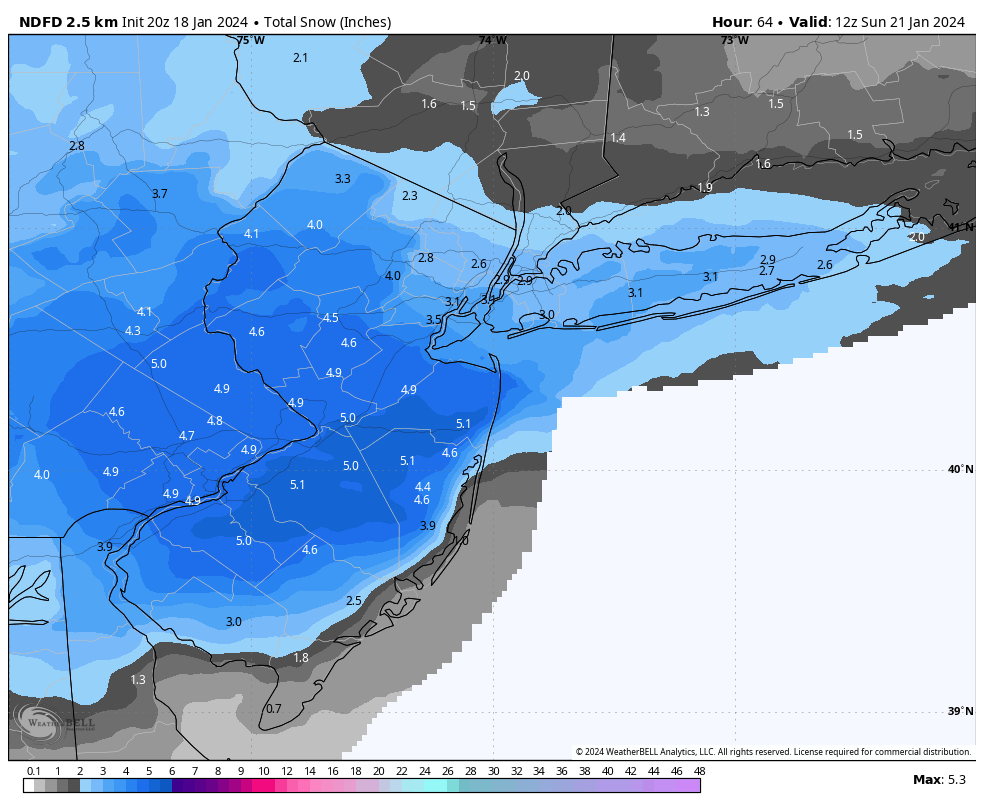
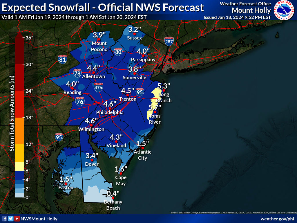
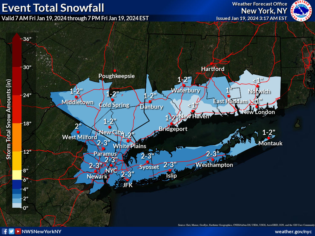
The NWS not only hasn't backed down given the general decrease in snowfall amounts seen at 12Z for most models, but they upped snowfall amounts a bit more, especially between about Rt 33 and a line from Wilmington, DE to LBI, where the NWS-Philly has winter storm warnings up (counties in pink, below) for Monmouth, Ocean, Burlington, Camden, Gloucester and Salem in NJ and Philly and its nearby N and W suburbs, for 5-6" of snow (and this is 6-7" of snow for Monmouth). Inland Atlantic and Cumberland have advisories for 2-4" and coastal Ocean, coastal Atlantic and Cape May only have advisories for 1-3"" due to some likely mixing/changing to rain.
Advisories are still up for 3-5" for all of the NWS-Philly counties N of the warning counties, i.e., the Lehigh Valley and Poconos in PA and Middlesex, Somerset, Hunterdon, Morris, Warren and Sussex in NJ, while the NWS-NYC advisories in adjacent Union/Essex/Hudson/Bergen/Passaic, as well as NYC/LI are for only 2-3" so there's clearly a difference in opinion between the two offices on this. My personal opinion, shared by many mets/experts on the weather boards, is that it's really unlikely to get more than 3" N of 78 and especially N of 80. Lee Goldberg, for example, has N of 78 only getting 1-3", but does have 3-6" south of 78. That's why I'll stick with my forecast of 3.3" for my house in Metuchen. The higher amounts south of 78, especially near 195 and south of there make sense assuming that's where the best inverted trough banding sets up.
Maps are below from the NWS, including a more detailed snowfall map for our entire region with many more locations detailed with forecast amounts (the NDFD map, which adjusts for ratios), plus I included the NBM (model blend map), which also includes adjustments for ratios likely being in the 14-18:1 range (inches of snow per inch or liquid), which is well above the typical 10:1 ratio, given the entire atmospheric column being below 32F and with good crystal growth expected, i.e., this will very likely be a fairly fluffy snow (low bulk density).
https://www.weather.gov/phi/
https://www.americanwx.com/bb/topic/59942-snow-friday-11924-is-it-a-period-ofn-light-snow-less-than-2-or-is-there-a-chance-of-a-5-swath-in-part-of-the-nyc-subforum-event-obs/page/20/
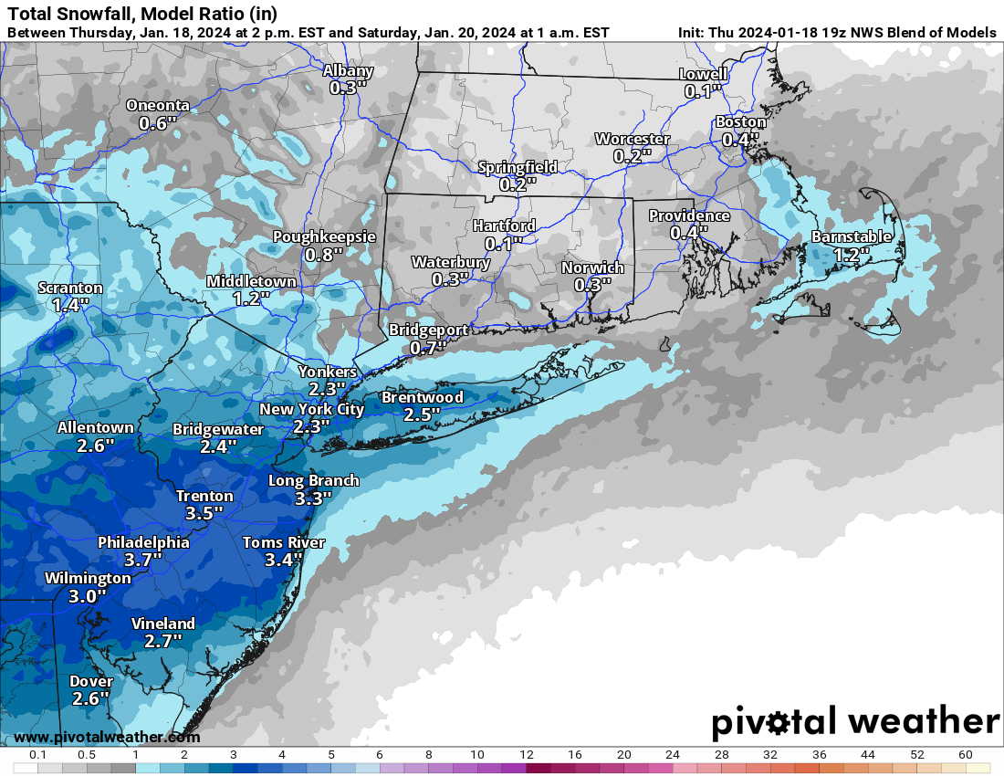
One more update before the storm - been away all night as it was our monthly poker night, but looks like I didn't miss much, as the models continue to show a fair amount less snow than the NWS-Philly. Really struggling to understand the difference and their rationale for the forecast, as they didn't really provide a rationale, at least not for why snowfall forecasts are significantly greater near and north of 78 than they are in any model, other than the HREF (the "ensemble" of high resolution moels).
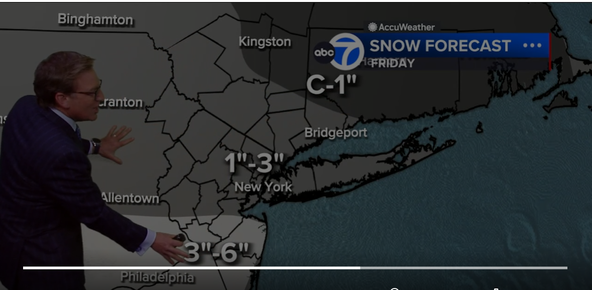
Anyway, the NWS-Philly actually increased snowfall in some places (for far southern NJ), with it's 9:52 pm update, while trimming back slightly in parts of CNJ/NNJ, relative to the 4 pm map. But they're still quite higher than most others forecasters, especially near and N of 78, where many to most models are showing 1-2" vs. the 3-5" forecast in the advisories. For example, Lee Goldberg moved his 3" line south 10 miles from about 78, as per below (with the 3" line now a couple of miles south of Metuchen) and only has 1-3" N of that line in contrast to the NWS 3-5" for that area. No change in the NWS-NYC map.
I guess we'll find out who's right on this one soon. I'm leaning towards Lee Goldberg's forecast
So this storm is off to a bad start. First some dry air moved in unexpectedly and has delayed the start. Snow amounts have been reduced especially North and West of Philadelphia back to 1-3 inches according to 6ABC.
Mt Holly is going to be bent over a barrel after this one. Whole state is shutting down over a 1-3, mostly 1-2 event.
25° and light snow this morning above Boone NC. Expecting 2" - 6" per the town forecast, but that could double up top here, adding to the 14" that fell earlier. Low around 5° tonight then 3° Saturday overnight. We were able to slip down the mountain yesterday for a resupply. Next midweek looks for a break in the temps possibly 52° by Thursday. Needing a good melt....
One more update before the storm - been away all night as it was our monthly poker night, but looks like I didn't miss much, as the models continue to show a fair amount less snow than the NWS-Philly. Really struggling to understand the difference and their rationale for the forecast, as they didn't really provide a rationale, at least not for why snowfall forecasts are significantly greater near and north of 78 than they are in any model, other than the HREF (the "ensemble" of high resolution moels).
Anyway, the NWS-Philly actually increased snowfall in some places (for far southern NJ), with it's 9:52 pm update, while trimming back slightly in parts of CNJ/NNJ, relative to the 4 pm map. But they're still quite higher than most others forecasters, especially near and N of 78, where many to most models are showing 1-2" vs. the 3-5" forecast in the advisories. For example, Lee Goldberg moved his 3" line south 10 miles from about 78, as per below (with the 3" line now a couple of miles south of Metuchen) and only has 1-3" N of that line in contrast to the NWS 3-5" for that area. No change in the NWS-NYC map.
I guess we'll find out who's right on this one soon. I'm leaning towards Lee Goldberg's forecast
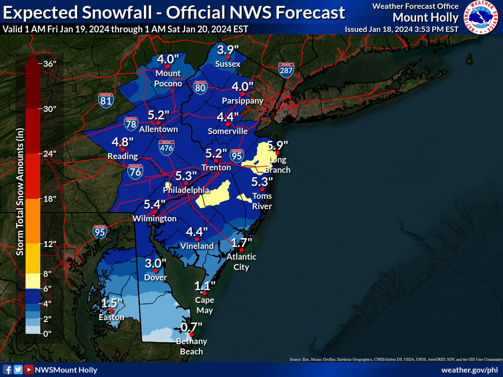
Looks like the NWS-Philly finally came to it senses a bit shaving a good 1-2" off of snowfall amounts north of about 276/195 and even dropping the warning for Monmouth and putting in an advisory for 3-5" for Monmouth. They still have advisories, though, from Middlesex to Mercer to NW Bucks/NW Montco all the way up to Sussex, calling for 2 to 4 inches with "the lowest amounts found north of I-80 and the highest amounts south of I-78."
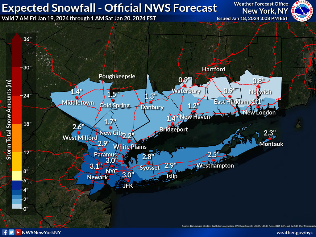
The NWS-NYC also cut back somewhat on their forecast dropping about 1" (they weren't as high to begin with), adjusting their advisories to 2-3" for NENJ from Union up to Bergen and for NYC/LI and southern Westchester. The NWS-Philly retained and expanded the warnings south of 276/195, all the way down through Atlantic/Cumberland for 4-6" of snow, with the only exceptions being Cape May and coastal Atlantic/Ocean having advisories for 2-4" of snow due to mixing with rain.
These adjustments all reflect that all of the models have been showing for at least 24 hours that the snow shield was shifting south and I'm still not convinced that anyone north of 80 gets over an inch and am concerned that nobody north of the Raritan will see over 2", but up to 3" towards 78 is at least possible and I'll have to stick with my 3.3" forecast for Metuchen, but doubt we'll get there (probably more like 2-2.5"). Even 2" of light fluffy snow accumulating on all but treated surfaces will still be impactful but not as much as 3-5" would have been. Also, the NWS-Philly discussion, below, finally explains what they're thinking...
Let's watch the radar and the sky now as snow looks like it has made it up towards the Raritan.
https://www.weather.gov/phi/
Area Forecast Discussion
National Weather Service Mount Holly NJ
656 AM EST Fri Jan 19 2024
Since Thursday afternoon, the last couple runs of various model
guidance has made a distinct shift south with the axis of heavier
snow amounts, focusing the inverted trough extending westward from
Friday`s coastal low back closer to the Delaware coast rather than
southern NJ. The initial steadier snow may set-up near the urban
corridor from Trenton southwest later this morning. Much of the
guidance suggests that the steadier snow will focus more on southern
NJ into Delaware at it`s peak this afternoon, and linger there
longest as the coastal low pulls away, dragging the inverted trough
behind it. While higher snow ratios may make up the difference for a
bit less liquid equivalent precipitation along the northern edge of
the steadier snow, with the southerly shift in the guidance, we had
to lower amounts by an inch or two across the northern half of our
area.
Considered dropping Advisory around Morris and Sussex Co NJ, but
given some fairly rough conditions for the evening commute as colder
air work in, it can be justified from an impacts standpoint. Did
drop the Warning for Monmouth County, as amounts look to fall short
of the 6" threshold there. Considered dropping Bucks to an Advisory
as well, but amounts are near enough to 5" criteria to let it ride a
this point. Meanwhile, farther south along the NJ shore and into the
Delmarva, with winds expected to stay more northeasterly (rather
than SE as earlier models projected), any initial rain may shift
over to snow more quickly with less marine influence. Additionally,
the axis of stronger forcing shifted south there as well. Added Kent
County (both MD and DE) along with inland Atlantic and Cumberland
County NJ to the Winter Storm Warning. Latest snow amounts in the
warning area are somewhat marginal for reaching criteria, right
around 5". However, given the tendency for higher ratios, the
possibility that models are underdoing some mesoscale lifting
mechanisms (coastal convergence, low-level convergence along the
inverted trough, and mid-level frontogenesis), we expect some
localized amounts near or even over 6 inches. Sometimes we expect
too much accuracy from the model guidance QPF; it would only take
another `surprise` 0.10-0.20 inches to exceed snowfall amounts by a
few inches.
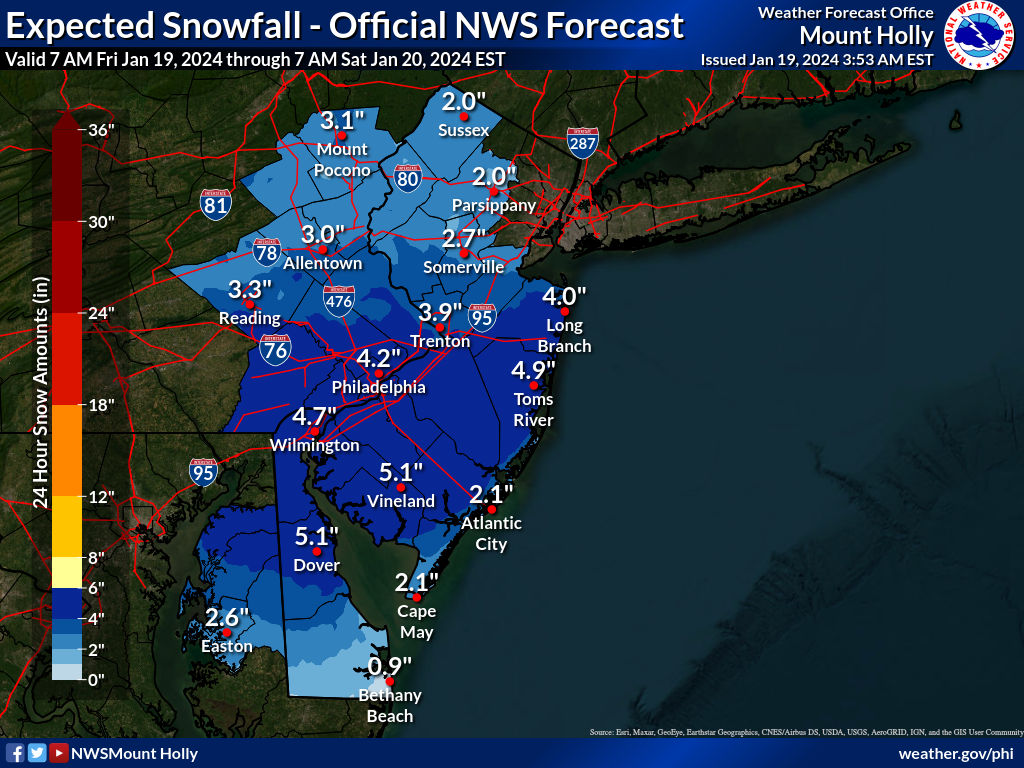
Why are you "concerned" that people will get less snow? Doesn't less snow mean less work and less accidents?Looks like the NWS-Philly finally came to it senses a bit shaving a good 1-2" off of snowfall amounts north of about 276/195 and even dropping the warning for Monmouth and putting in an advisory for 3-5" for Monmouth. They still have advisories, though, from Middlesex to Mercer to NW Bucks/NW Montco all the way up to Sussex, calling for 2 to 4 inches with "the lowest amounts found north of I-80 and the highest amounts south of I-78."
The NWS-NYC also cut back somewhat on their forecast dropping about 1" (they weren't as high to begin with), adjusting their advisories to 2-3" for NENJ from Union up to Bergen and for NYC/LI and southern Westchester. The NWS-Philly retained and expanded the warnings south of 276/195, all the way down through Atlantic/Cumberland for 4-6" of snow, with the only exceptions being Cape May and coastal Atlantic/Ocean having advisories for 2-4" of snow due to mixing with rain.
These adjustments all reflect that all of the models have been showing for at least 24 hours that the snow shield was shifting south and I'm still not convinced that anyone north of 80 gets over an inch and am concerned that nobody north of the Raritan will see over 2", but up to 3" towards 78 is at least possible and I'll have to stick with my 3.3" forecast for Metuchen, but doubt we'll get there (probably more like 2-2.5"). Even 2" of light fluffy snow accumulating on all but treated surfaces will still be impactful but not as much as 3-5" would have been. Let's watch the radar and the sky now as snow looks like it has made it up towards the Raritan.
https://www.weather.gov/phi/
Well, everything closed prematurelyWhy are you "concerned" that people will get less snow? Doesn't less snow mean less work and less accidents?
Similar threads
- Replies
- 62
- Views
- 2K
- Replies
- 608
- Views
- 18K
OT: Minor to Moderate (2-4?) Snowfall Likely Sat morning (2/17); will be <32F, so expect slick roads
- Replies
- 213
- Views
- 5K
- Replies
- 771
- Views
- 20K
ADVERTISEMENT
ADVERTISEMENT