
He know more than mets? Oh boy is right. Go tell it on the mountain that #'s is the king."which the vast majority of mets don't know that much about and neither do you. But I do."
Oh boy.
Colleges
- American Athletic
- Atlantic Coast
- Big 12
- Big East
- Big Ten
- Colonial
- Conference USA
- Independents (FBS)
- Junior College
- Mountain West
- Northeast
- Pac-12
- Patriot League
- Pioneer League
- Southeastern
- Sun Belt
- Army
- Charlotte
- East Carolina
- Florida Atlantic
- Memphis
- Navy
- North Texas
- Rice
- South Florida
- Temple
- Tulane
- Tulsa
- UAB
- UTSA
- Boston College
- California
- Clemson
- Duke
- Florida State
- Georgia Tech
- Louisville
- Miami (FL)
- North Carolina
- North Carolina State
- Pittsburgh
- Southern Methodist
- Stanford
- Syracuse
- Virginia
- Virginia Tech
- Wake Forest
- Arizona
- Arizona State
- Baylor
- Brigham Young
- Cincinnati
- Colorado
- Houston
- Iowa State
- Kansas
- Kansas State
- Oklahoma State
- TCU
- Texas Tech
- UCF
- Utah
- West Virginia
- Illinois
- Indiana
- Iowa
- Maryland
- Michigan
- Michigan State
- Minnesota
- Nebraska
- Northwestern
- Ohio State
- Oregon
- Penn State
- Purdue
- Rutgers
- UCLA
- USC
- Washington
- Wisconsin
High Schools
- Illinois HS Sports
- Indiana HS Sports
- Iowa HS Sports
- Kansas HS Sports
- Michigan HS Sports
- Minnesota HS Sports
- Missouri HS Sports
- Nebraska HS Sports
- Oklahoma HS Sports
- Texas HS Hoops
- Texas HS Sports
- Wisconsin HS Sports
- Cincinnati HS Sports
- Delaware
- Maryland HS Sports
- New Jersey HS Hoops
- New Jersey HS Sports
- NYC HS Hoops
- Ohio HS Sports
- Pennsylvania HS Sports
- Virginia HS Sports
- West Virginia HS Sports
ADVERTISEMENT
OT: Could the snow drought end next weekend (1/7)? Maybe...
- Thread starter RU848789
- Start date
Numbers = RutgersAl of weather threadsIt really is just a series of "Look at me" posts under the cover of bad weather forecasting.

How’s that bac ass tasting, T2K?As our snowless streak continues, Mr. Wishcasting will get more and more desperate. Funny to watch a grown adult try to justify credentials when he has none.....and knows it.
Keep focusing on the potential flooding. That's the real story!
My son is asking me to take him to Blue Mountain tomorrow. Looking for advice…would conditions be okay for evening skiing? Driving conditions ok as long as I get there by 1PM/2PM?
I think you weather guys know this guy?I assume because intimate knowledge of physical chemistry isn't really critical to learning about synoptic forecasting. I love P-chem, which is why I tend to make contributions on those boards where I have expertise. I can't hold a candle to pro mets on synoptics, but I know a ton about P-chem as it relates to things like melting, crystallization, snow/sleet physical properties and how they impact frozen precip removal (surface area to volume ratio is really important there), so I try to make contributions there. Let me know if I got that right or am way off base...
You, bac and the rest of the dweebs are the most pathetic losers around .^^^^^ Someone is cranky after no meaningful snow for about 600 days and counting.
Numbers keep forecasting. The other 99% get it.
Seems the cutoff line keeps moving further north every time they update this.
Really enjoy your posts for the last few years - but gotta call you out in this thread. Bias and defensive - kind of like watching the news. SorryI assume because intimate knowledge of physical chemistry isn't really critical to learning about synoptic forecasting. I love P-chem, which is why I tend to make contributions on those boards where I have expertise. I can't hold a candle to pro mets on synoptics, but I know a ton about P-chem as it relates to things like melting, crystallization, snow/sleet physical properties and how they impact frozen precip removal (surface area to volume ratio is really important there), so I try to make contributions there. Let me know if I got that right or am way off base...
I kinda do also agree with this. Your pro-snow bias was pretty evident here the last few days. lol.Really enjoy your posts for the last few years - but gotta call you out in this thread. Bias and defensive - kind of like watching the news. Sorry
Still will continue to follow your weather posts.
He is an informed pro snow weather forecaster who cites many possible scenarios. He’s up front about his prosnowness. We all know there is uncertainty and volatility. If you can find a completely impartial individual with numbers knowledge who will post on this board, let me know.I kinda do also agree with this. Your pro-snow bias was pretty evident here the last few days. lol.
Still will continue to follow your weather posts.
He is an informed pro snow weather forecaster who cites many possible scenarios. He’s up front about his prosnowness. We all know there is uncertainty and volatility. If you can find a completely impartial individual with numbers knowledge who will post on this board, let me know.
He certainly is very informed…hence why I said I’m going to continue to follow his threads to see his thoughts..
It seemed this thread was overly pro snow from him…at least my opinion. I don’t necessarily care…but it was just extra this thread..
I disagree. He seems to point out the uncertainties. I did not get the sense he was like the news media who does pump the “whatever is problematic scenario”He certainly is very informed…hence why I said I’m going to continue to follow his threads to see his thoughts..
It seemed this thread was overly pro snow from him…at least my opinion. I don’t necessarily care…but it was just extra this thread..
Yes, he's CCB from 33andrain (he's a mod there) and while an amateur met, he's very good and posts on twitter and other social media platforms. I'll try to elaborate further, since I'm pretty sure you'll think this is cool stuff - this is very similar to work I did in R&D for years on small organic molecule crystallization/growth (snow isn't really that different from a fundamental perspective). What he showed there (it's called a "sounding" of the atmospheric column at a specific place and time from the surface up to 100 mbar or 40,000 feet up) is very close to what I've been saying, i.e., with heavy snowfall intensity rates and good saturation up the column to about 18,000 feet or the DGZ or dendritic growth zone (you can see DGZ on the left at around 500 HPa or mbar and can see that the red and green lines - the actual temp and the dew point temp are very close indicating saturated air at that height).
The DGZ is where one gets the best snow crystal growth (fluffy dendrites under good conditions) from lifted moist air from lower levels in the atmosphere, which cools rapidly up there at around -10 to -18C, becoming supersaturated, leading to very fast vapor phase deposition of that water vapor onto seed nuclei, forming nice dendrites if conditions are right, leading to puking snowfall rates, producing eventual high intensity snow (3/4-1" per hour snowfall rates) falling through a column that is below 32F the whole trip down until just reaching the surface which will likely be around 34-35F along 95. This will melt initially, but briefly, as very quickly falling snow will overcome the melting at the ground rather quickly and start accumulating.
The graphic below illustrates the types of crystal habits formed under various levels of supersaturation at various temps in the DGZ with dendrites being favored at high supersaturation and -10 to -18C aloft (dendrites can give snow ratios of 20:1 or more, i.e, 1" of liquid can give 20" of snow - that's what one gets with great powder snow). We might get a mix of dendrites and plates, which could give us ratios of 10:1 or better for a few hours despite all the talk about warm temps and low Kuchera ratios. The graphic is from the blog entry linked below which is an excellent piece on what goes into snow crystal growth and snow ratios.
https://lukemweather.blogspot.com/2010/12/finallyhow-do-we-calculate-snow-ratios.html
At that point one has a layer of 32F snow/slush on the ground and once that toehold is there, subsequent snow falls on that now 32F surface (not 34-35F bare ground), leading to greatly reduced melting and rapid accumulation, since air at 34-35F doesn't do much melting as the heat transfer coefficient of air is ~20X lower than liquid (or solid). The best way to think of this is that it's far easier to hold one's hand in a -10F freezer without discomfort for a minute or two than it is to hold one's hand in a 32F ice-water bath (like a beer cooler), which can only be done for seconds, since water transports heat away from the skin ~20X faster than air.
Anyway, he's postulating (and some models show as per those soundings over time) that we could have those conditions from maybe 6 or 7 pm (at times - it won't always be heavy precip), which could put down a quick 2-3" in that 3-4 hour period even with surface temps of 34-35F. Eventually, warmer air moves in aloft at around 5000 feet typically (850 mbar) causing the falling snowflakes from 18,000 feet to melt partly or completely on their descent, leading to rain or white rain (snow so wet it won't accumulate). This is why I'm still calling for ~2" of snow at my house (which shows similar soundings as his tweet, since we're in that red box he's showing, plus one can get a sounding for any lat/long on every model at 1 hour intervals usually), despite some models showing nada or <1". We'll see soon if that's right or not.

Thanks and I thought I tried hard to not be too pro snow (I am pro snow, of course, but try to not let that color my discussions). My apologies if that didn't come across well.He certainly is very informed…hence why I said I’m going to continue to follow his threads to see his thoughts..
It seemed this thread was overly pro snow from him…at least my opinion. I don’t necessarily care…but it was just extra this thread..
Thanks. Are you saying you thought I was biased/defensive throughout or just that post? That post was certainly a bit defensive, but sometimes one gets a little tired of being attacked and I'm not above firing back sometimes. My actual weather posts, I thought, were not biased. I'm not calling for 2" at my house for example because I "want" snow - it's because I truly think we can get it based on the post I just made explaining my rationale for good crystal growth and limited melting for a few hours tomorrow. I could end up being wrong, but that happens and hopefully I learn from it.Really enjoy your posts for the last few years - but gotta call you out in this thread. Bias and defensive - kind of like watching the news. Sorry
Thanks and I thought I tried hard to not be too pro snow (I am pro snow, of course, but try to not let that color my discussions). My apologies if that didn't come across well.
No prob..,like I said it doesn’t bother me at all! Someone being pro or anti snow has zero effect on the weather, lol.
I'd say if you get there by 1-2 pm you should be fine on the roads and will have some great skiing in falling snow, which is a blast for me. Used to go to Blue a lot as it's close and low key. The way home could be a little tougher with 6-10" of snow likely out there, although I've skied on heavier snowfall days and they do a good job with the roads around there. Have fun!My son is asking me to take him to Blue Mountain tomorrow. Looking for advice…would conditions be okay for evening skiing? Driving conditions ok as long as I get there by 1PM/2PM?
Sadly, there haven't even been many misses last year or this year, as we generally haven't even had good chances. Even if you don't get much snow, you should consider getting in the car (maybe on Sunday when roads will be better) and driving up to the juge sledding hill at Schooley Mountain Park (Long Valley - also a couple of great pubs nearby including Valley Restaurant/Pub). It's the best sledding I know of within 45 minutes of my house with a vertical drop of probably 150' and my son and his friends always loved going up there, as I used to take them up there on the day after snowfalls from the time they were about 10-11 (it can get a little crowded and maybe too fast for younger kids), but it does have hay bales protecting sledders from hitting the tree line on the one side. Great time spent with your kids...Hey, we are in the same boat. Trolling snow threads after 600 days of misses gets dull. The wishcasters like you need to win from time to time to keep it interesting! Also, my little one is hoping for at least one sled'able event this winter.
Numbers, you don't have to apologize for a damn thing to anyone. I've said it before and i'll say it again to every single person that ever steps foot in a rutgers rivals forum...............if you don't like what numbers has to say regarding the weather.......STOP OPENING THE POSTS IN THE FIRST PLACE......If you feel he is overly pro snow and it you know that (in your mind) going in, then......simply.....stop......opening......his.......damn......weather......threads! I personally like his take on the weather. And even if he takes a pro snow stance, he absolutely gives other perspectives on how something may not happen snow wise......and does a particularly good job of referencing where he gets much of the information. Numbers, keep doing your thing.....I like your weather threads...........everyone else who is annoyed........ummmm, please stay out!Thanks and I thought I tried hard to not be too pro snow (I am pro snow, of course, but try to not let that color my discussions). My apologies if that didn't come across well.
Welcome to the crowd who actually doesn't even read my posts. I don't "forecast" anything, per se. I share data, graphics and analysis/insights from the models and pros and try to explain some things at times, but I don't make forecasts, which I make clear all the time. Doesn't mean I don't have some very specific expertise on some non-forecasting elements of meteorology based on science areas I know extremely well. I get a lot of props from pros and non-pros on the weather boards for those insights, so some seem to like them. There have been a few comments on not using the 10:1 ratio snowfall graphics in situations like this where there will be mixed precip, which I get. even if I personally still prefer the 10:1 ratio maps.It really is just a series of "Look at me" posts under the cover of bad weather forecasting.
THAT may have been your best weather post ever. Crystals and dendritic growth? Bring it on! I can't remember why I followed that guy in Twitter, but it had nothing to do with weather.Yes, he's CCB from 33andrain (he's a mod there) and while an amateur met, he's very good and posts on twitter and other social media platforms. I'll try to elaborate further, since I'm pretty sure you'll think this is cool stuff - this is very similar to work I did in R&D for years on small organic molecule crystallization/growth (snow isn't really that different from a fundamental perspective). What he showed there (it's called a "sounding" of the atmospheric column at a specific place and time from the surface up to 100 mbar or 40,000 feet up) is very close to what I've been saying, i.e., with heavy snowfall intensity rates and good saturation up the column to about 18,000 feet or the DGZ or dendritic growth zone (you can see DGZ on the left at around 500 HPa or mbar and can see that the red and green lines - the actual temp and the dew point temp are very close indicating saturated air at that height).
The DGZ is where one gets the best snow crystal growth (fluffy dendrites under good conditions) from lifted moist air from lower levels in the atmosphere, which cools rapidly up there at around -10 to -18C, becoming supersaturated, leading to very fast vapor phase deposition of that water vapor onto seed nuclei, forming nice dendrites if conditions are right, leading to puking snowfall rates, producing eventual high intensity snow (3/4-1" per hour snowfall rates) falling through a column that is below 32F the whole trip down until just reaching the surface which will likely be around 34-35F along 95. This will melt initially, but briefly, as very quickly falling snow will overcome the melting at the ground rather quickly and start accumulating.
The graphic below illustrates the types of crystal habits formed under various levels of supersaturation at various temps in the DGZ with dendrites being favored at high supersaturation and -10 to -18C aloft (dendrites can give snow ratios of 20:1 or more, i.e, 1" of liquid can give 20" of snow - that's what one gets with great powder snow). We might get a mix of dendrites and plates, which could give us ratios of 10:1 or better for a few hours despite all the talk about warm temps and low Kuchera ratios. The graphic is from the blog entry linked below which is an excellent piece on what goes into snow crystal growth and snow ratios.
https://lukemweather.blogspot.com/2010/12/finallyhow-do-we-calculate-snow-ratios.html
At that point one has a layer of 32F snow/slush on the ground and once that toehold is there, subsequent snow falls on that now 32F surface (not 34-35F bare ground), leading to greatly reduced melting and rapid accumulation, since air at 34-35F doesn't do much melting as the heat transfer coefficient of air is ~20X lower than liquid (or solid). The best way to think of this is that it's far easier to hold one's hand in a -10F freezer without discomfort for a minute or two than it is to hold one's hand in a 32F ice-water bath (like a beer cooler), which can only be done for seconds, since water transports heat away from the skin ~20X faster than air.
Anyway, he's postulating (and some models show as per those soundings over time) that we could have those conditions from maybe 6 or 7 pm (at times - it won't always be heavy precip), which could put down a quick 2-3" in that 3-4 hour period even with surface temps of 34-35F. Eventually, warmer air moves in aloft at around 5000 feet typically (850 mbar) causing the falling snowflakes from 18,000 feet to melt partly or completely on their descent, leading to rain or white rain (snow so wet it won't accumulate). This is why I'm still calling for ~2" of snow at my house (which shows similar soundings as his tweet, since we're in that red box he's showing, plus one can get a sounding for any lat/long on every model at 1 hour intervals usually), despite some models showing nada or <1". We'll see soon if that's right or not.
I just want some snow on the grassy areas in Mercer county so my son can play in snow for the first time.
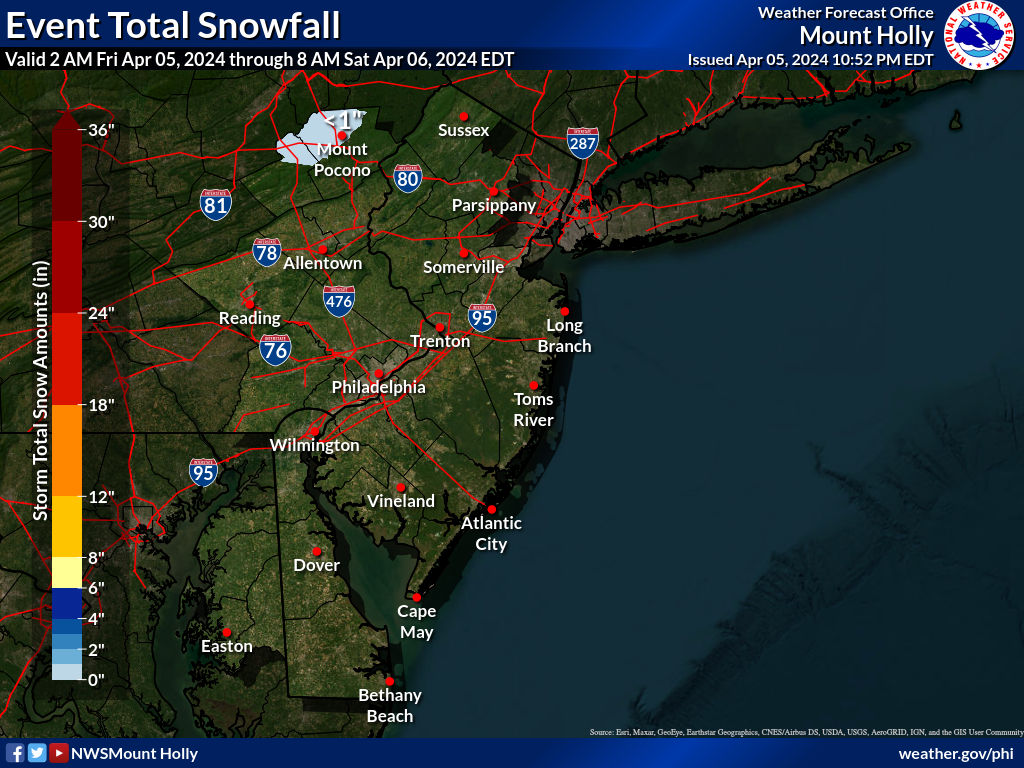
Latest NWS maps, as the NWS-Philly bumped up snowfall along 95 and a bit NW of 95 with advisories now up from the NWS-Philly for the counties in blue in the map below, from western Chester, western Montco, western Bucks, Hunterdon and Somerset for 2-4/3-5" of snow and from the NWS-NYC for up to 4" for western Union, western Essex, eastern Bergen, eastern Passaic and southern Westchester. Problem is that the actual advisories simply say those amounts for the whole counties, like Somerset/Hunterdon, when those amounts are only forecast for the northern parts of those counties near and north of 78 - poor communication, IMO. For example, Somerville is only forecast to get 1.1" of snow and it's in Somerset Co, lol.
Winter storm warnings in pink are up from the NWS-Philly for the Poconos/Sussex for 8-12", the Lehigh Valley and Warren/Morris for 6-8" and they're up from the NWS-NYC for W. Passaic, NW Bergen and the Hudson Valley N or the Tappan Zee/interior CT for 4-8" of snow. Again some of these counties, like Morris will actually only have 2-45 in the SE portions with 6-8" only in the NW part of the county - again, poor communication. One more reason why many of these counties need to be split in half, like some others are (like Bucks/Montco).
Finally, there are still models (latest 6Z GFS/NAM/NAM3K) showing several inches of snow near/along the 95 corridor (closer to route 1 really) from SE Somerset to NYC, including my house of course, so I'm sticking with my 2" forecast and hoping for more - while there are other models showing only an inch or so, so it's still possible those areas get mostly rain with little snow. Going to be a very close call from Trenton to NYC and even down to Philly (especially the NW part) has a shot at 1-2" of snow. Those areas all need the initial thump of precip to be all/mostly snow from about 3-7 pm and to have enough intensity to accumulate with surface temps at 34-35F or so. Could also still be an inch or so on the backend especially for NENJ/NYC and NE of there (esp LI). Enjoy and be safe everyone.
https://www.weather.gov/phi/
All of Mercer except maybe the extreme SE part ought to get at least a small accumulation on the grass...and NW Mercer could easily get 1-2". Good luck - I miss those times from when my son was young - treasure them.I just want some snow on the grassy areas in Mercer county so my son can play in snow for the first time.
I for one enjoy these threads and the inevitable banter back and for between #’s and bac. Just wish bac didn’t hit so hard and for #’s to stop trying to convince us all he smart and qualified.
Thanks! Did you learn about any of that at RU (ceramic eng'g, iirc)? We never really did much on crystallization in chemE - most of my experience in that came at Merck.THAT may have been your best weather post ever. Crystals and dendritic growth? Bring it on! I can't remember why I followed that guy in Twitter, but it had nothing to do with weather.
Thanks! Always appreciate your posts. Their going to try to ski to close at 9PM if possible. I booked a hotel about 30 miles south of the mountain. Hopefully my ride back to hotel is okay.I'd say if you get there by 1-2 pm you should be fine on the roads and will have some great skiing in falling snow, which is a blast for me. Used to go to Blue a lot as it's close and low key. The way home could be a little tougher with 6-10" of snow likely out there, although I've skied on heavier snowfall days and they do a good job with the roads around there. Have fun!
Thanks for all the information, Numbers. It looks like it will be safe for me to travel the NJT to Parx for poker this afternoon and return tonight.
I think we have covered the ceramic engineering majors were required to take mineralogy and petrology through the Geological Sciences department. Also took an elective in Crystal Chemistry through Ceramic Engineering. Some of the process chemistry patents I work on now for chipmaking involve either promotion or suppression of crystallization. I've been stuck in the weeds of monoclonic, triclinic, 110 and 111 planes quite a few times. Fun stuff!Thanks! Did you learn about any of that at RU (ceramic eng'g, iirc)? We never really did much on crystallization in chemE - most of my experience in that came at Merck.
Ceramic engineering classes at RU:I think we have covered the ceramic engineering majors were required to take mineralogy and petrology through the Geological Sciences department. Also took an elective in Crystal Chemistry through Ceramic Engineering. Some of the process chemistry patents I work on now for chipmaking involve either promotion or suppression of crystallization. I've been stuck in the weeds of monoclonic, triclinic, 110 and 111 planes quite a few times. Fun stuff!

Actually, my daughters school runs an annual skiing/snow-tubing trip for the middle school division. Last year's trip was a blast for them. Also did a smaller snow-tubing trip for the girl scouts in the greater Princeton area. But obviously, no neighborhood fun, which is always special.Sadly, there haven't even been many misses last year or this year, as we generally haven't even had good chances. Even if you don't get much snow, you should consider getting in the car (maybe on Sunday when roads will be better) and driving up to the juge sledding hill at Schooley Mountain Park (Long Valley - also a couple of great pubs nearby including Valley Restaurant/Pub). It's the best sledding I know of within 45 minutes of my house with a vertical drop of probably 150' and my son and his friends always loved going up there, as I used to take them up there on the day after snowfalls from the time they were about 10-11 (it can get a little crowded and maybe too fast for younger kids), but it does have hay bales protecting sledders from hitting the tree line on the one side. Great time spent with your kids...
Birthday party postponed.
Already had 2 parents reach out with concerns about the weather and the party ending at 9:30pm.
Out of an abundance of caution, moving it 2 weeks.
These new age millennial parents are wimps.

Already had 2 parents reach out with concerns about the weather and the party ending at 9:30pm.
Out of an abundance of caution, moving it 2 weeks.
These new age millennial parents are wimps.
Akshually, worked on this stuff at RU. LMK if you need a technical dictionary or an interpreter. Me and @RU848789 can draw pictures for you:Ceramic engineering classes at RU:
The effect of magnetic fields to 15T on the electrical resistance (R) of Bi-Sr-Ca-Cu-O superconductors has been measured at precise temperatures during the transition to the superconducting state. The results show that the temperature at which the externally-applied magnetic field causes a divergence of resistance (R) as a function of inverse temperature is approximately at the same temperature where the positive Hall coefficient begins its steep descent to zero. At slightly higher temperature the Hall coefficient shows a singularity peak akin to a delta function. Internal electric field calculations show that the structure of the superconducting oxides, having more than a single building block polyhedron, gives rise to strong electrostatic fields in the unit cell which in turn causes charge separation or polarization. The charge separation is in accord with the importance of high oxidation states of the multivalence cations and suggests the use of high oxygen overpressure during processing. The magnitude of Tc scales closely with the number of bound holes (associated with the charge transfer excitations) per unit cell. Extensive computer calculations using this model indicate attractive pairing of electrons at inter-electron separations of about 10–15A.
The perovskite structure in Pb(Zn1/3Nb2/3)O3 can be stabilized by the addition of Pb(Ni1/3Nb2/3)O3 and PbTiO3.Pb(Ni1/3Nb2/3)O3 assists in lowering the sintering temperature and shifting the Curie temperature of ceramics while PbTiO3 helps to optimize the dielectric properties. The phase stability and dielectric properties of several compositions in the Pb(Zn1/3Nb2/3)O3-Pb(Ni1/3Nb2/3)O3-PbTiO3 ternary relaxor ferroelectric system were investigated for possible capacitor applications. The effect of calcining and sintering temperature on the stability of perovskite phase in PZN rich compositions was studied extensively as a function of composition. The boundary line separating perovskite and mixed phases was determined for compositions near PZN. Several compositions can be sintered below 1050°C. The dielectric properties of compositions near the mixed phase boundary showed strong dependence on the percentage of pyrochlore phase. Compositions with a dielectric constant of 12.500 at room temperature have been identified which meet Z5T and Y5U specifications for dielectric constant and tan δ
Did the State declare a state of emergency yet? Asking for a friend.Birthday party postponed.
Already had 2 parents reach out with concerns about the weather and the party ending at 9:30pm.
Out of an abundance of caution, moving it 2 weeks.
These new age millennial parents are wimps.
Did the State declare a state of emergency yet? Asking for a friend.
My wife and I were like "I guess we have to be accommodating......."
We were ready to make 15 2nd graders get home in the snow at 9:30pm.
Luckily the place let us move it despite the short notice because of the "weather".
Akshually, worked on this stuff at RU. LMK if you need a technical dictionary or an interpreter. Me and @RU848789 can draw pictures for you:
The effect of magnetic fields to 15T on the electrical resistance (R) of Bi-Sr-Ca-Cu-O superconductors has been measured at precise temperatures during the transition to the superconducting state. The results show that the temperature at which the externally-applied magnetic field causes a divergence of resistance (R) as a function of inverse temperature is approximately at the same temperature where the positive Hall coefficient begins its steep descent to zero. At slightly higher temperature the Hall coefficient shows a singularity peak akin to a delta function. Internal electric field calculations show that the structure of the superconducting oxides, having more than a single building block polyhedron, gives rise to strong electrostatic fields in the unit cell which in turn causes charge separation or polarization. The charge separation is in accord with the importance of high oxidation states of the multivalence cations and suggests the use of high oxygen overpressure during processing. The magnitude of Tc scales closely with the number of bound holes (associated with the charge transfer excitations) per unit cell. Extensive computer calculations using this model indicate attractive pairing of electrons at inter-electron separations of about 10–15A.
The perovskite structure in Pb(Zn1/3Nb2/3)O3 can be stabilized by the addition of Pb(Ni1/3Nb2/3)O3 and PbTiO3.Pb(Ni1/3Nb2/3)O3 assists in lowering the sintering temperature and shifting the Curie temperature of ceramics while PbTiO3 helps to optimize the dielectric properties. The phase stability and dielectric properties of several compositions in the Pb(Zn1/3Nb2/3)O3-Pb(Ni1/3Nb2/3)O3-PbTiO3 ternary relaxor ferroelectric system were investigated for possible capacitor applications. The effect of calcining and sintering temperature on the stability of perovskite phase in PZN rich compositions was studied extensively as a function of composition. The boundary line separating perovskite and mixed phases was determined for compositions near PZN. Several compositions can be sintered below 1050°C. The dielectric properties of compositions near the mixed phase boundary showed strong dependence on the percentage of pyrochlore phase. Compositions with a dielectric constant of 12.500 at room temperature have been identified which meet Z5T and Y5U specifications for dielectric constant and tan δ
EHHHHH?
Thanks for the info as always. Hoping my little guy can enjoy a little snow! Fingers crossed.All of Mercer except maybe the extreme SE part ought to get at least a small accumulation on the grass...and NW Mercer could easily get 1-2". Good luck - I miss those times from when my son was young - treasure them.
Where are you located that snow is a concern at 9:30pmMy wife and I were like "I guess we have to be accommodating......."
We were ready to make 15 2nd graders get home in the snow at 9:30pm.
Luckily the place let us move it despite the short notice because of the "weather".
Similar threads
- Replies
- 733
- Views
- 37K
- Replies
- 135
- Views
- 7K
- Replies
- 33
- Views
- 2K
ADVERTISEMENT
Latest posts
-
BB Recruiting NJIT Transfer G Tariq Francis commits to Rutgers Basketball
- Latest: Scarlet Shack
-
BB Recruiting Darren Buchanan Jr. has committed to Rutgers Basketball
- Latest: willisneverrana43
-
-

-
ADVERTISEMENT