
Colleges
- American Athletic
- Atlantic Coast
- Big 12
- Big East
- Big Ten
- Colonial
- Conference USA
- Independents (FBS)
- Junior College
- Mountain West
- Northeast
- Pac-12
- Patriot League
- Pioneer League
- Southeastern
- Sun Belt
- Army
- Charlotte
- East Carolina
- Florida Atlantic
- Memphis
- Navy
- North Texas
- Rice
- South Florida
- Temple
- Tulane
- Tulsa
- UAB
- UTSA
- Boston College
- California
- Clemson
- Duke
- Florida State
- Georgia Tech
- Louisville
- Miami (FL)
- North Carolina
- North Carolina State
- Pittsburgh
- Southern Methodist
- Stanford
- Syracuse
- Virginia
- Virginia Tech
- Wake Forest
- Arizona
- Arizona State
- Baylor
- Brigham Young
- Cincinnati
- Colorado
- Houston
- Iowa State
- Kansas
- Kansas State
- Oklahoma State
- TCU
- Texas Tech
- UCF
- Utah
- West Virginia
- Illinois
- Indiana
- Iowa
- Maryland
- Michigan
- Michigan State
- Minnesota
- Nebraska
- Northwestern
- Ohio State
- Oregon
- Penn State
- Purdue
- Rutgers
- UCLA
- USC
- Washington
- Wisconsin
High Schools
- Illinois HS Sports
- Indiana HS Sports
- Iowa HS Sports
- Kansas HS Sports
- Michigan HS Sports
- Minnesota HS Sports
- Missouri HS Sports
- Nebraska HS Sports
- Oklahoma HS Sports
- Texas HS Hoops
- Texas HS Sports
- Wisconsin HS Sports
- Cincinnati HS Sports
- Delaware
- Maryland HS Sports
- New Jersey HS Hoops
- New Jersey HS Sports
- NYC HS Hoops
- Ohio HS Sports
- Pennsylvania HS Sports
- Virginia HS Sports
- West Virginia HS Sports
ADVERTISEMENT
OT: Could the snow drought end next weekend (1/7)? Maybe...
- Thread starter RU848789
- Start date


And you don't even know the difference between forecasting (which is all about what's going on in the atmosphere and what's going to fall from the sky, when and where and why) and evaluating column-induced hydrometeor melting and microphysics and surface melting vs. accumulation, which the vast majority of mets don't know that much about and neither do you. But I do.You are trying to tell mets how to forecast. You are clinging to the snowier models when 90% of the models are quite similar
People actually care abow how much snow falls AS IN ACCUMULATING
Your hubris knows no end. Im not trolling just take a loss on this considering you are the only on Americanwx taking this bizarre stand. The forecast is pretty cut and dry right now
I'm also not clinging to anything: just pointing out the differences among the models along 95, which is called analysis. Yes, things have trended warmer and wetter over the past 2 days, but so be it - have you seen me post anything out of the ordinary with regard to a forecast? Didn't think so, as my 1-2" call for 95 from Trenton to NYC is in line with many pros, even if not the NWS, but that happens. Will I be wrong? Maybe, maybe not, but if I am, I'll gladly acknowledge it.
Why don't you go ahead and engage me in a scientific discussion on the weather board and see how fast people laugh you out of existence and how fast the mods ban you, since you'll go troll at some point, like they always do, as that's your nature, when you can't win an argument.
^^^^^ Someone is cranky after no meaningful snow for about 600 days and counting.
We appreciate you numbers ! Some of us make plans and want to know the forecast !And you don't even know the difference between forecasting (which is all about what's going on in the atmosphere and what's going to fall from the sky, when and where and why) and evaluating column-induced hydrometeor melting and microphysics and surface melting vs. accumulation, which the vast majority of mets don't know that much about and neither do you. But I do.
I'm also not clinging to anything: just pointing out the differences among the models along 95, which is called analysis. Yes, things have trended warmer and wetter over the past 2 days, but so be it - have you seen me post anything out of the ordinary with regard to a forecast? Didn't think so, as my 1-2" call for 95 from Trenton to NYC is in line with many pros, even if not the NWS, but that happens. Will I be wrong? Maybe, maybe not, but if I am, I'll gladly acknowledge it.
Why don't you go ahead and engage me in a scientific discussion on the weather board and see how fast people laugh you out of existence and how fast the mods ban you, since you'll go troll at some point, like they always do, as that's your nature, when you can't win an argument.
It’s a shame what happened to this thread
Are you still calling for 1-2 inches in metuchen ?
#s I enjoy your posts. In fact, when a snow forecast is made, I come to this board to get the real scoop. Why not just put Bac and a few others on ignore.
And you don't even know the difference between forecasting (which is all about what's going on in the atmosphere and what's going to fall from the sky, when and where and why) and evaluating column-induced hydrometeor melting and microphysics and surface melting vs. accumulation, which the vast majority of mets don't know that much about and neither do you. But I do.
I'm also not clinging to anything: just pointing out the differences among the models along 95, which is called analysis. Yes, things have trended warmer and wetter over the past 2 days, but so be it - have you seen me post anything out of the ordinary with regard to a forecast? Didn't think so, as my 1-2" call for 95 from Trenton to NYC is in line with many pros, even if not the NWS, but that happens. Will I be wrong? Maybe, maybe not, but if I am, I'll gladly acknowledge it.
Why don't you go ahead and engage me in a scientific discussion on the weather board and see how fast people laugh you out of existence and how fast the mods ban you, since you'll go troll at some point, like they always do, as that's your nature, when you can't win an argument.
Wtf are you even talking about. So great I hit a nerve. I loved how you had to declare your credentials on that board. Your argument is over some minutiae thats not going to matter in this storm. I have no interest in discussing science with you especially given your "science" from 2020-2022
How about we stick to the forecast here instead of petty arguments. You have a beef that i said most models are aligned because you were rooting for the outliers to find someway to be true. Thats where you chimed in responding to me. Has zero to do with science and you not being able to admit you were wrong
As our snowless streak continues, Mr. Wishcasting will get more and more desperate. Funny to watch a grown adult try to justify credentials when he has none.....and knows it.Wtf are you even talking about. So great I hit a nerve. I loved how you had to declare your credentials on that board. Your argument is over some minutiae thats not going to matter in this storm. I have no interest in discussing science with you especially given your "science" from 2020-2022
How about we stick to the forecast here instead of petty arguments. You have a beef that i said most models are aligned because you were rooting for the outliers to find someway to be true
Keep focusing on the potential flooding. That's the real story!
Yes I am, but that's kind of a guess. Could be anywhere from 0-5" to be honest with 1-2" seeming most likely.We appreciate you numbers ! Some of us make plans and want to know the forecast !
It’s a shame what happened to this thread
Are you still calling for 1-2 inches in metuchen ?
And thanks.
Thanks! I mostly ignore them these day, but once in awhile when a specific argument comes up, I'll engage. Turns out several others who also get annoyed with the trolling got into it with them in this thread, not me for the most part. Back to the weather - just posted a thread about the upcoming flooding threat for Tues/Weds...#s I enjoy your posts. In fact, when a snow forecast is made, I come to this board to get the real scoop. Why not just put Bac and a few others on ignore.
"which the vast majority of mets don't know that much about and neither do you. But I do."
Oh boy.
Oh boy.
Wrong again - we had a whopping 5.2" of snow in Metuchen last winter as did many along 95 outside of the NENJ/NYC urban heat island. Not cranky at all - even if we miss, I still greatly enjoy tracking. Enjoy your continued trolling.^^^^^ Someone is cranky after no meaningful snow for about 600 days and counting.
"which the vast majority of mets don't know that much about and neither do you. But I do."
Oh boy.
Yup so great
It's actually quite true. Would you like to discuss it in detail? It's a fascinating topic, IMO."which the vast majority of mets don't know that much about and neither do you. But I do."
Oh boy.
Hey, we are in the same boat. Trolling snow threads after 600 days of misses gets dull. The wishcasters like you need to win from time to time to keep it interesting! Also, my little one is hoping for at least one sled'able event this winter.Wrong again - we had a whopping 5.2" of snow in Metuchen last winter as did many along 95 outside of the NENJ/NYC urban heat island. Not cranky at all - even if we miss, I still greatly enjoy tracking. Enjoy your continued trolling.
It's actually quite true. Would you like to discuss it in detail? It's a fascinating topic, IMO.
And what does it have to do with forecasting amounts for this storm
Red tagged mets told people to stop hugging those snow clown maps that came out yesterday. Your desire to make the higher amounts happen made you dismiss all the other knowledge of temperature winds and soundings and meterological science which you are not skilled in
Are you still calling for 1-2 inches in metuchen ?
Well if that's all they're getting in Hillsborough the MILF's are just gonna stay home.
Swing and miss for CNJ!
Who cares about CNJ?
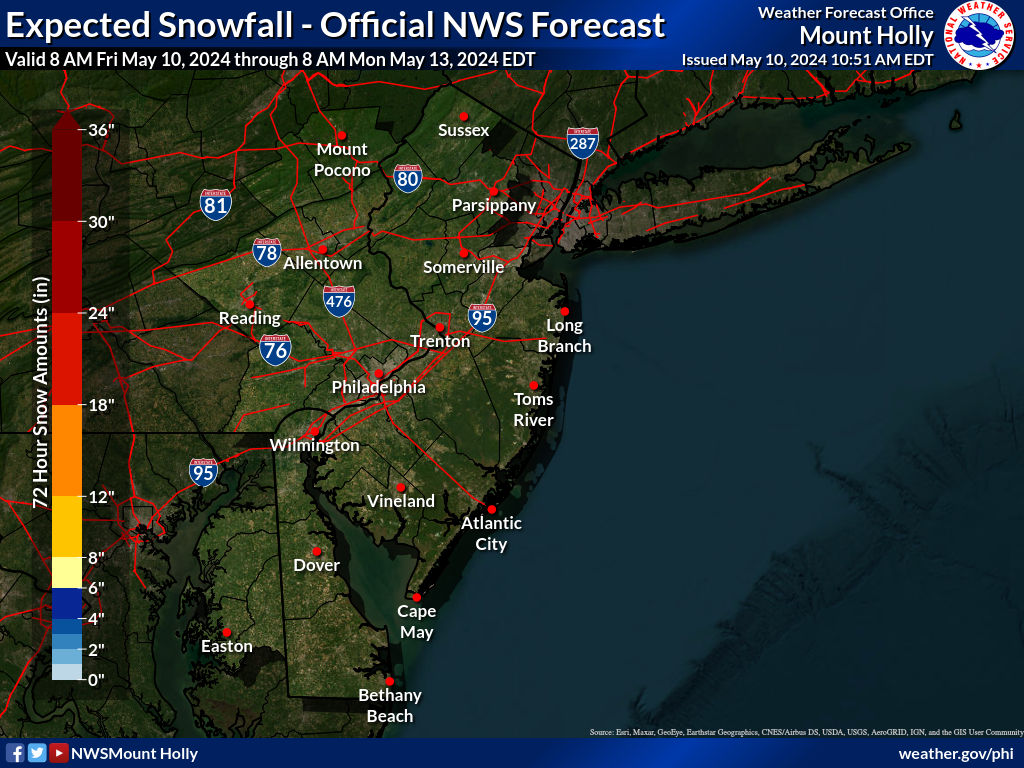
Based on that map I'm getting 2-4" which isn't the dusting/rain some have been downplaying.
It's not 8" but it's not nothing.
Last edited:
Well if that's all they're getting in Hillsborough the MILF's are just gonna stay home.
Lol
Well if that's all they're getting in Hillsborough the MILF's are just gonna stay home.
I heard there us a big fish fry coming
How cares about CNJ?
Based on that map I'm getting 2-4" which isn't the dusting/rain some have been downplaying.
It's not 8" but it's not nothing.
Who have been downplaying?
Swing and miss for CNJ!
I pretty much called that on Wednesday. Pat myself on the back…lol
NJZ007-008-061100-
/O.CON.KPHI.WS.W.0001.240106T1800Z-240107T2300Z/
Warren-Morris-
Including the cities of Washington and Morristown
259 PM EST Fri Jan 5 2024
...WINTER STORM WARNING REMAINS IN EFFECT FROM 1 PM SATURDAY TO
6 PM EST SUNDAY...
* WHAT...Heavy snow expected. Total snow accumulations of 4 to 8
inches.
* WHERE...Warren and Morris.
* WHEN...From 1 PM Saturday to 6 PM EST Sunday.
* IMPACTS...Travel could be very difficult.
* ADDITIONAL DETAILS...At lower elevations (less than 500 feet
above sea-level), snowfall totals will be reduced.
PRECAUTIONARY/PREPAREDNESS ACTIONS...
If you must travel, keep an extra flashlight, food, and water in
your vehicle in case of an emergency.
The latest road conditions for the state you are calling from can
be obtained by calling 5 1 1.
&&
$$
NJZ009-PAZ060>062-105-061100-
/O.EXT.KPHI.WW.Y.0001.240106T1800Z-240107T1100Z/
Hunterdon-Berks-Lehigh-Northampton-Upper Bucks-
Including the cities of Flemington, Reading, Allentown,
Bethlehem, Easton, Chalfont, and Perkasie
259 PM EST Fri Jan 5 2024
...WINTER WEATHER ADVISORY NOW IN EFFECT FROM 1 PM SATURDAY TO
6 AM EST SUNDAY...
* WHAT...Wet snow expected. Total snow accumulations of 3 to 6
inches.
* WHERE...In New Jersey, Hunterdon. In Pennsylvania, Berks,
Lehigh, Northampton and Upper Bucks.
* WHEN...From 1 PM Saturday to 6 AM EST Sunday.
* IMPACTS...Plan on slippery road conditions.
PRECAUTIONARY/PREPAREDNESS ACTIONS...
Slow down and use caution while traveling.
The latest road conditions for the state you are calling from can
be obtained by calling 5 1 1.


Heading out for awhile, but one more thing. Note that heavy precip is now forecast to come in a little earlier, i.e., by about 2-3 pm in CNJ and an hour or two earlier towards Philly and maybe an hour later in NYC. The early part of the storm, through about 7 pm is the time where it's most likely that areas along the 95 corridor might see some decent snowfall, although most models are showing snow or a mixed bag changing to all rain after maybe an inch or two of accumulation along 95 (although several inches are possible, in theory, if that changeover is delayed 1-2 hours as the precip rate will be about 1" per hour of snow; mostly/all rain is also possible along 95). From 3 pm to about 1-2 am is the time when the all-snow areas will get most of their 5-10" (or more). Still could be some wraparound snow tomorrow morning into the early afternoon, but likely less than 1" from that, unless one is NE of NYC.
Want to know why most meteorologists don't know a lot about that obscure topic?It's actually quite true. Would you like to discuss it in detail? It's a fascinating topic, IMO.
It's actually quite true. Would you like to discuss it in detail? It's a fascinating topic, IMO.
Well I figure if Pro Mets feel they don't need it then it's probably more of an ego massage to talk about it. This is supposed to be about the weather - not the folks who post about it. Or is that just an excuse to generate attention and boost post counts?
Philadelphia on 705 days without 1" of snow. Jan 29 will be 2 full years. Last year's measurement at the airport for a trace was such BS as the real Philadelphia had Zip-A-Do-Dah. I'm not routing for no snow of any measurement but I certainly don't want to shovel. The ocean higher temps killed this storm and it's not a true Nor'easter storm as the winds will shift the the south east.Wrong again - we had a whopping 5.2" of snow in Metuchen last winter as did many along 95 outside of the NENJ/NYC urban heat island. Not cranky at all - even if we miss, I still greatly enjoy tracking. Enjoy your continued trolling.
I assume because intimate knowledge of physical chemistry isn't really critical to learning about synoptic forecasting. I love P-chem, which is why I tend to make contributions on those boards where I have expertise. I can't hold a candle to pro mets on synoptics, but I know a ton about P-chem as it relates to things like melting, crystallization, snow/sleet physical properties and how they impact frozen precip removal (surface area to volume ratio is really important there), so I try to make contributions there. Let me know if I got that right or am way off base...Want to know why most meteorologists don't know a lot about that obscure topic?
NimberSan only wants to debate things until the facts come out and he's wrong. He's already cluttering the board with other weather threads because he flamed out in this one.
Loves to dance but never pays the band. @Richard Schnyderite I recommend a move of all weather threads to the CE boards which is where they belong. With a stern warning if you start another you are banned here.
Loves to dance but never pays the band. @Richard Schnyderite I recommend a move of all weather threads to the CE boards which is where they belong. With a stern warning if you start another you are banned here.
BS. The weather threads are great and a lot of people appreciate the effort. If you don't like them, pretty simple. Stay the F away. Please. Much better than ruining every one of them with stupid ass comments that add nothing
Funny thing is we're well aligned on RU sports and I would still talk sports with bac any day of the week...
His basketball analysis was great...before we became a field hockey school.
I assume because intimate knowledge of physical chemistry isn't really critical to learning about synoptic forecasting. I love P-chem, which is why I tend to make contributions on those boards where I have expertise. I can't hold a candle to pro mets on synoptics, but I know a ton about P-chem as it relates to things like melting, crystallization, snow/sleet physical properties and how they impact frozen precip removal (surface area to volume ratio is really important there), so I try to make contributions there. Let me know if I got that right or am way off base...
It really is just a series of "Look at me" posts under the cover of bad weather forecasting.
Similar threads
- Replies
- 748
- Views
- 37K
- Replies
- 135
- Views
- 7K
- Replies
- 33
- Views
- 2K
ADVERTISEMENT
ADVERTISEMENT