ADVERTISEMENT

OT: Heavy Rain Thursday (2/3), Ending as Some Freezing Rain, Sleet, Snow Friday?

Well, the next 7 days look like a rollercoaster with some warmer temps the next couple of days, then a major winter storm that looks mostly wet for our area Thursday/Friday, possibly ending icy/snowy, followed by very cold temps for the weekend, possibly followed by a more wintry storm next Monday. The Thursday/Friday event will be a huge snowstorm (a foot or more) for much of the Plains, Midwest/Great Lakes and then the northern tier from Cleveland to central/northern New England and possibly much further south (all the way down to I-84 on a couple of models) with a foot or more of snow on Thursday/Friday.

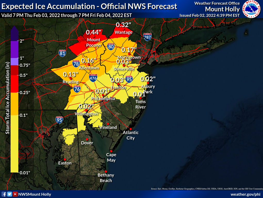
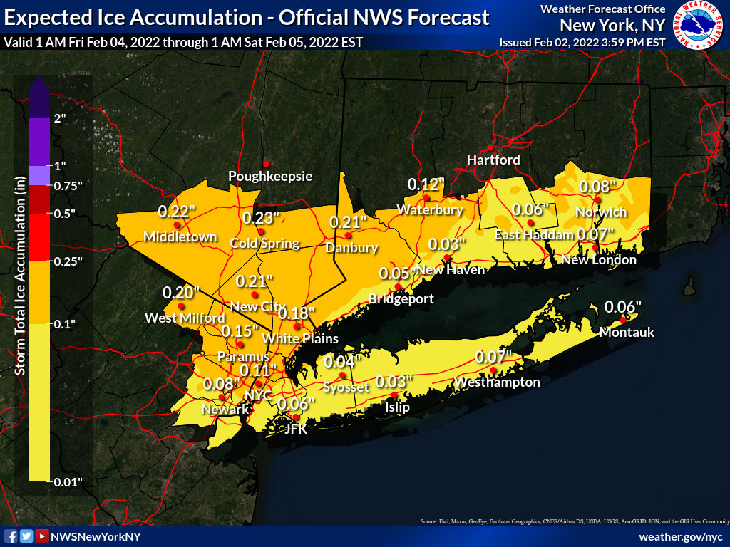
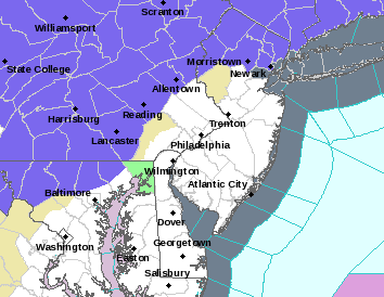
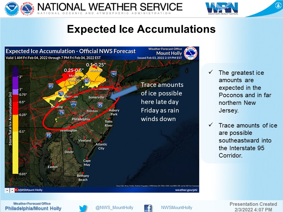
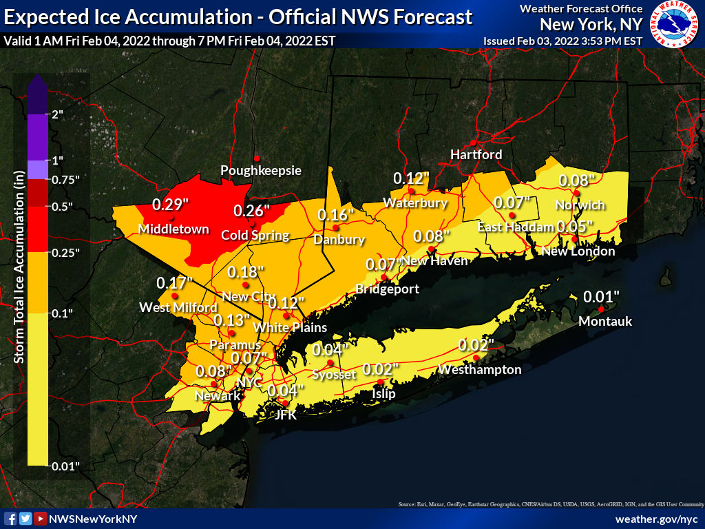
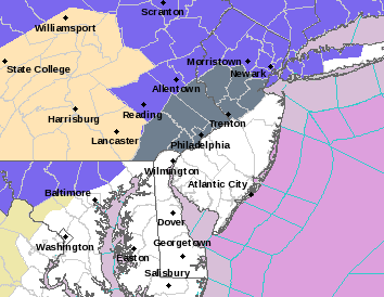
With regard to the main point of this thread, however, most of the models are showing heavy rain (1-2") for the Philly-NJ-NYC area, Thursday into Friday, which could lead to urban flooding due to rain + melting snow (although probably 1/2" to 1" of rain would be largely absorbed in the snowpack, especially near the coast where 12"+ of snow fell,, but more than 1" of rain would likely lead to a lot more melting/runoff), but then enough cold air coming in on Friday morning to give the northern parts of our area some freezing rain (and maybe a bit of sleet and then snow), with the freezing rain scenario being especially concerning, with maybe 0.1-0.2" of freezing rain along and N of 78.

However, two models, the UK (which has been horrible this winter) and the GFS, which has done pretty well this winter (except for Saturday), are showing a much colder solution with this “southwest flow event” (from a low approaching from the Midwest), bringing heavy rain, then a potentially serious ice storm (1/2" or more of ice accretion) as far south as 276/195 late Thursday into Friday, followed by a few inches of sleet and then snow after that – but until there is support from other models, these should be considered as outliers, like when both of these models were showing only snow for the coast 3-4 days before Saturday’s storm. In this case, though, the GFS has been rock solid on this solution for several runs and this setup is very different, as it's not a coastal low, where the GFS has a known SE track bias, plus the cold front approaching from Canada is a very strong one, so it's possible the cold air push into our area is being undermodeled by the other models, especially as they have been trending a bit colder since yesterday. So, while the GFS (and UK) is an outlier, it can't be ignored, at this time, and the evolution of this system needs to be watched very closely. Stay tuned on this one, as the models are so far apart from each other now that confidence is very low. See the NWS discussion below.

All models agree that in the wake of this storm, it gets very cold this weekend with temps possibly dipping into the single digits for many on Saturday and Sunday mornings with very cold wind chills, plus if there is any freezing rain on Friday, the ice could stick around for awhile with the very cold temps. Also, as mentioned above we have another opportunity for a winter storm to affect our area on Monday. While this one is further out, it actually has better model support for at least a moderate snowstorm for most of the area. Not worth saying much more on that one yet, as it's too far out for more than a heads up.

https://www.weather.gov/phi/

https://www.americanwx.com/bb/topic...event-some-snow-possible-far-interior/page/7/

Area Forecast Discussion
National Weather Service Mount Holly NJ
624 AM EST Tue Feb 1 2022

LONG TERM /THURSDAY THROUGH MONDAY/...

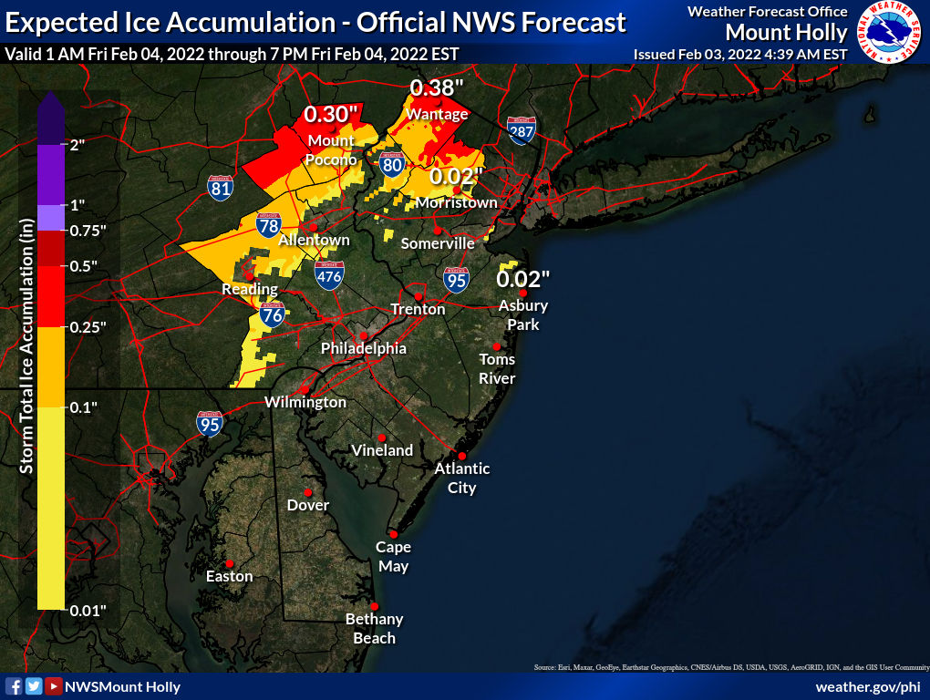
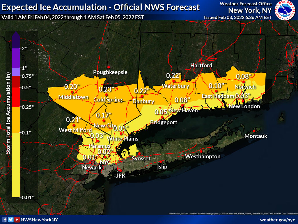
For Thursday and Friday...A strong cold front to our northwest
will gradually move into the region during this time as a wave
of low pressure tracks along it. Ahead of the front, a much
milder air mass will move in as heights continue to rise and
surface winds remain southerly. Areas mainly along and
south/east of I-95 will climb into the 50s on Thursday. Gradual
rain development from northwest to southeast is expected as the
front slowly approaches, although much of the day may remain dry
south and east of I-95. We then watch the evolution of the
front as this will be critical to the arrival time of the cold
air. Model agreement is not great regarding the evolution of
this system, with the GFS charging the strong cold front faster
southeastward which results in a much colder solution and
therefore a significant snow and ice event for at least the
northern half of the region. However, other guidance remains
warmer with mainly rain with the exception for the very far
north as the low tracks just north of us. This would bring
another round of temperatures in the upper 40s and 50s on
Friday. The GFS has been consistent the past several runs in a
farther southward push of the front/cold air. The last few runs
of the ECMWF (including the new 00z run) has been shifting ever
so slightly southward though as well, so even though the GFS
seems to be a cold outlier it cannot be completely ruled out.
With a very strong arctic high to the north of this frontal
system and at least some lingering snowpack over parts of our
region, the setup is ripe for models to display some warm bias.
For now, we continued to indicate a changeover to a wintry mix
for at least parts of our northern and western zones.
Temperatures should start to fall during Friday afternoon as
strong cold air advection surges southeastward.

For Friday night...We see the departure of the frontal system.
As the cold front moves away, arctic air will rush into the
region. The mild conditions of Thursday and Friday will be
replaced by readings in the teens and 20s. The overall evolution
of the system will determine how precipitation ends. It is
typically a challenge to get a rain to ice to snow event to
occur as the precipitation is usually tapering off or ending
before the colder air arrives. However, if the colder model
solutions are right the rain/ice/snow line will collapse towards
the coast late in the event. The further north you go, the
better the chances for a lengthier period of frozen
precipitation near the end of the system. Either way, with the
temperatures likely to be crashing, the setup looks quite
favorable for a rapid freeze-up Friday night, so we will be
keeping an eye on this.
Do you know this guy?

 
Do you know this guy?

I don’t, as I never heard of him, but found this part of the story very interesting…


As his reputation grew, his following swelled to 35,000 followers. But he stopped posting there in April of 2020.

“I got a message from Facebook saying I could sway too many voters because I had so many followers,” he said. “I said, ‘What are you talking about? I do the weather. I don’t even allow politics on my page.


Burger said Facebook froze his access to the page.

“They said, ‘We can’t verify what country you’re in,'" he said. "I said, ‘What country am I in?! I’ve lived in the same house my entire life. There are 35,000 people who know where I live.'”
 
I don’t, as I never heard of him, but found this part of the story very interesting…


As his reputation grew, his following swelled to 35,000 followers. But he stopped posting there in April of 2020.

“I got a message from Facebook saying I could sway too many voters because I had so many followers,” he said. “I said, ‘What are you talking about? I do the weather. I don’t even allow politics on my page.’”
Noticed that too. It's a terrible platform. Rarely log on, and will probably close my account soon. Noticed that many FB "friends" have closed their accounts, and fewer people are posting. Maybe it will go the way of Myspace?
 
NWS-Philly forecast is a fair amount icier at 4 pm than it was this morning, especially N of 78, while the NWS-NYC ice forecast is similar. What might be more concerning is that the GFS is no longer alone in a very icy solution, as the 18Z NAM joined the 18Z GFS with very icy solutions (0.10-.25" even for the 95 corridor north of Trenton). Will have to see if this is a blip or a trend...

ACqttlu.png


GxNIfRb.png

Interesting that the models didn't change much, as the 0Z and 6Z NAM/GFS from last night and this morning, still show 0.1-0.2" of freezing rain N of the Raritan/202, while the rest of the models generally only show freezing rain N or 78 or 80, but the NWS backed off considerably on freezing rain forecasts for anywhere along and S of 78 for Friday morning/afternoon.

As a result, winter weather advisories (counties in blue, below) for freezing rain are only up for counties along and N of 80. The GFS/NAM have been rock solid on their icing forecasts for a couple of days, so if they end up being right, there will be some surprised folks in CNJ (along and NW of 95) and NYC. Let's hope they're wrong, as nobody needs 0.1-0.2" of freezing rain. The NWS does, however, note that they could be wrong on this, as per the bolded part below from their discussion...

Also, we're looking at 1-1.5" of rain for most of the area from now through Friday morning, with up to 2" N of 78, so that, along with a fair amount of melting snow, will lead to localized urban flooding, especially in poor drainage areas. For areas near the coast, who got 12+ inches of snow, where they might get <1" of rain, it's also possible that the existing large snowpack can absorb much of the rain without it all melting (creating essentially large areas of slush), such that when temps crash below freezing Friday afternoon, they could be left with a glacial landscape in spots. Also, any standing water will freeze solid everywhere. Lastly, the snow threat I mentioned a couple of days ago for Monday, is dead, as the phasing isn't going to occur, so the storm will go well out to sea to our SE.

Area Forecast Discussion
National Weather Service Mount Holly NJ
639 AM EST Thu Feb 3 2022

SHORT TERM /6 PM THIS EVENING THROUGH SATURDAY NIGHT/...
We have not made much change to the overall precipitation
forecast for Thursday night into Friday.

The precipitation is expected to be all rain in our region on
Thursday evening. A low level southwesterly jet in excess of 60
knots is anticipated to pass over our region from Thursday night
into Friday morning, enhancing rainfall rates. Liquid
equivalent precipitation amounts are expected to favor the 1.0
to 1.5 inch range to the northwest of the Interstate 95 Corridor
in our region, and 0.5 to 1.0 inch to the southeast. There is
the potential for localized flooding in areas of poor drainage.

In regard to the leading edge of the arctic air, a wave
developing on the approaching frontal boundary should slow its
arrival a bit. However, we continue to expected the front to
pass through our region from late Thursday night into Friday
morning. The rain should begin to transition to freezing rain in
the Poconos between 1:00 AM and 4:00 AM. Fortunately, most of
the moderate to heavy rain will fall in advance of the boundary.
The transition is forecast to work its way into Berks County,
the Lehigh Valley and northwestern New Jersey early on Friday
morning. All the above areas are now included in a Winter
Weather Advisory.

While the transition to freezing rain should arrive in
southeastern Pennsylvania and central New Jersey on Friday
morning, the timing is a bit more uncertain than for areas to
the northwest. As a result, we have not included those locations
in the advisory but they may be added as we get closer to the
event.


There is even more uncertainty as to whether freezing rain will
be an issue from the Interstate 95 Corridor southeastward.
Temperatures may not fall below freezing there until late Friday
afternoon as the back edge of the precipitation begins to move
off the coast.


Ij0F9zD.png


rPt3HzP.png


21V3qwL.png
 
Last edited:
Do you know this guy?

Have heard of him, but I generally just follow a few key meteorologists in the media and on the weather boards/FB/twitter. At first I thought maybe it was the Bob Burgers of rock and roll fame, who is also from the Shore area and is a member of the great band, The Weeklings and has been doing solo shows for many years all over the area, but after looking at the FB page, they're clearly separate people.
 
  • Like
Reactions: Knight Shift
Serious ice events are very rare around these parts. Mt Holly always errs on the side of caution so them downplaying the event is telling. When you get closer to the events when the models actually become ACCURATE these type of events look less serious and that has been the trend with this one

But also models do get it wrong and we do get smaller surprise icing so nowcasting radar and temps become more important than model watching from here on out
 
  • Like
Reactions: RU848789
Serious ice events are very rare around these parts. Mt Holly always errs on the side of caution so them downplaying the event is telling. When you get closer to the events when the models actually become ACCURATE these type of events look less serious and that has been the trend with this one

But also models do get it wrong and we do get smaller surprise icing so nowcasting radar and temps become more important than model watching from here on out
Agreed, but the vast majority of our freezing rain events are when coastal lows come too close and warm air at the upper levels converts the falling snow to rain, but we still have surface temps below 32F - it seems those scenarios almost always give the coastal plain/95 less freezing rain than modeled. However, this is almost the opposite setup, with a low approaching from the west along with a cold front from the NW, such that the precip will do the opposite, i.e., turn from rain to freezing rain to sleet to snow as the cold air moves in - if the precip hangs on long enough and we have these much less frequently, which is why I think uncertainty is pretty high and why we're still seeing model divergence on freezing rain amounts. Will likely not have a great handle on this until tomorrow night.
 
Have heard of him, but I generally just follow a few key meteorologists in the media and on the weather boards/FB/twitter. At first I thought maybe it was the Bob Burgers of rock and roll fame, who is also from the Shore area and is a member of the great band, The Weeklings and has been doing solo shows for many years all over the area, but after looking at the FB page, they're clearly separate people.
THAT Bob Burger is also an intellectual property attorney at a large Newark, NJ firm.

He also had a heart attack on stage last June, but fortunately, he was playing very close to a hospital, and it worked out well for him. He's lucky!!

"I felt fine all day, but upon hitting the stage, I felt a little weird. That feeling got worse and worse during the set. After about an hour, I realized I could not go on. I apologized to the audience and asked John Merjave to finish out the show (which he did!). I went back to the dressing room, covered in sweat, and very pale with chest pains. Tony Pallagrosi quickly assembled the Basie EMT staff. With his quick action, Tony saved my life.

I didn’t know or think it was a heart attack initially. The EMTs told me that. They then called 911 / Riverview. I was quickly taken in the ambulance and admitted. The cardiac unit operated within an hour with a stent operation. I had 100% blockage of my main “widowmaker” artery. I would not have lasted for long without the operation. But as soon as they put in the stent, the pain and illness instantly stopped. Amazing!!"


Agreed, but the vast majority of our freezing rain events are when coastal lows come too close and warm air at the upper levels converts the falling snow to rain, but we still have surface temps below 32F - it seems those scenarios almost always give the coastal plain/95 less freezing rain than modeled. However, this is almost the opposite setup, with a low approaching from the west along with a cold front from the NW, such that the precip will do the opposite, i.e., turn from rain to freezing rain to sleet to snow as the cold air moves in - if the precip hangs on long enough and we have these much less frequently, which is why I think uncertainty is pretty high and why we're still seeing model divergence on freezing rain amounts. Will likely not have a great handle on this until tomorrow night.


well every model has been cutting qpf
 
  • Like
Reactions: Knight Shift
Well, if the colder models are correct, we'd see ice starting around dawn on Friday with things getting icy by mid morning I would think, although it needs to get a bit below 32F at the surface to see much accretion, especially since it will have been warmer/rainy before any freezing rain. Precip should be just about over by the evening rush hour, which could be impacted a bit if the worst case verifies, but my guess is it'll be ok as freezing rain forecasts often underdeliver - but I would stay tuned and be ready to adjust plans if needed.
Two questions
Asking for a friend who is planning on driving up to Massachusetts on Friday (a town on the coast north of Boston. How bad will the ride be and is there an optimal time to leave?

Asking for me - what will Saturday morning look like. I am driving from New Providence to Manchester NJ (exit 89 on GSP I believe) for a wake. Will things have passed by then?
 
Last edited:
  • Like
Reactions: 611george
I don’t, as I never heard of him, but found this part of the story very interesting…

As his reputation grew, his following swelled to 35,000 followers. But he stopped posting there in April of 2020. “I got a message from Facebook saying I could sway too many voters because I had so many followers,” he said. “I said, ‘What are you talking about? I do the weather. I don’t even allow politics on my page.

Burger said Facebook froze his access to the page.

“They said, ‘We can’t verify what country you’re in,'" he said. "I said, ‘What country am I in?! I’ve lived in the same house my entire life. There are 35,000 people who know where I live.'”

That kind of censorship is horrible.
 
  • Like
Reactions: bac2therac
I don’t, as I never heard of him, but found this part of the story very interesting…


As his reputation grew, his following swelled to 35,000 followers. But he stopped posting there in April of 2020.

“I got a message from Facebook saying I could sway too many voters because I had so many followers,” he said. “I said, ‘What are you talking about? I do the weather. I don’t even allow politics on my page.


Burger said Facebook froze his access to the page.

“They said, ‘We can’t verify what country you’re in,'" he said. "I said, ‘What country am I in?! I’ve lived in the same house my entire life. There are 35,000 people who know where I live.'”

Noticed that too. It's a terrible platform. Rarely log on, and will probably close my account soon. Noticed that many FB "friends" have closed their accounts, and fewer people are posting. Maybe it will go the way of Myspace?

I saw the future. The Forbes article says: "Shares of Facebook-parent Meta fell over 25% on Thursday—erasing over $230 billion in market value for its worst trading session in history—after a post on The Knight Report Football Board by Knight Shift stated that he rarely logs onto Facebook and will probably close his account soon." 🤣

 
Dear god, it's raining here. The HORROR!

Just got power back 2 hours ago, I guess that was a dress rehearsal for tomorrow morning.

Will tomorrow's ice have a vanilla flavor to it?

 
  • Like
Reactions: goru1869
The freezing rain has made the windows opaque. Judy says the sleets 3-4 inches thick on the upper deck. Only 2 inches thick on the lower deck though. We do get a lot of wind here for it to accumulate on the upper deck though.

Frozen Razorback margaritas are my mid-afternoon libation of choice today. Probably switching to neat bourbon tonight. Gotta warm up next to the fireplace!
 
  • Like
Reactions: RU848789
And, since you will ask……
16 ounces of your favorite Margarita mix.
8 ounces of good tequila.
in a blender with ice. Mix well.
Pour in your margarita glass.
1 quarter of squeezed lime.
pour 1.5 ounces of Grand Marnier over the top of your glass.
enjoy responsibly, or not.
 
  • Like
Reactions: Jm0513
Interesting that the models didn't change much, as the 0Z and 6Z NAM/GFS from last night and this morning, still show 0.1-0.2" of freezing rain N of the Raritan/202, while the rest of the models generally only show freezing rain N or 78 or 80, but the NWS backed off considerably on freezing rain forecasts for anywhere along and S of 78 for Friday morning/afternoon.

As a result, winter weather advisories (counties in blue, below) for freezing rain are only up for counties along and N of 80. The GFS/NAM have been rock solid on their icing forecasts for a couple of days, so if they end up being right, there will be some surprised folks in CNJ (along and NW of 95) and NYC. Let's hope they're wrong, as nobody needs 0.1-0.2" of freezing rain. The NWS does, however, note that they could be wrong on this, as per the bolded part below from their discussion...

Also, we're looking at 1-1.5" of rain for most of the area from now through Friday morning, with up to 2" N of 78, so that, along with a fair amount of melting snow, will lead to localized urban flooding, especially in poor drainage areas. For areas near the coast, who got 12+ inches of snow, where they might get <1" of rain, it's also possible that the existing large snowpack can absorb much of the rain without it all melting (creating essentially large areas of slush), such that when temps crash below freezing Friday afternoon, they could be left with a glacial landscape in spots. Also, any standing water will freeze solid everywhere. Lastly, the snow threat I mentioned a couple of days ago for Monday, is dead, as the phasing isn't going to occur, so the storm will go well out to sea to our SE.

Area Forecast Discussion
National Weather Service Mount Holly NJ
639 AM EST Thu Feb 3 2022

SHORT TERM /6 PM THIS EVENING THROUGH SATURDAY NIGHT/...
We have not made much change to the overall precipitation
forecast for Thursday night into Friday.

The precipitation is expected to be all rain in our region on
Thursday evening. A low level southwesterly jet in excess of 60
knots is anticipated to pass over our region from Thursday night
into Friday morning, enhancing rainfall rates. Liquid
equivalent precipitation amounts are expected to favor the 1.0
to 1.5 inch range to the northwest of the Interstate 95 Corridor
in our region, and 0.5 to 1.0 inch to the southeast. There is
the potential for localized flooding in areas of poor drainage.

In regard to the leading edge of the arctic air, a wave
developing on the approaching frontal boundary should slow its
arrival a bit. However, we continue to expected the front to
pass through our region from late Thursday night into Friday
morning. The rain should begin to transition to freezing rain in
the Poconos between 1:00 AM and 4:00 AM. Fortunately, most of
the moderate to heavy rain will fall in advance of the boundary.
The transition is forecast to work its way into Berks County,
the Lehigh Valley and northwestern New Jersey early on Friday
morning. All the above areas are now included in a Winter
Weather Advisory.

While the transition to freezing rain should arrive in
southeastern Pennsylvania and central New Jersey on Friday
morning, the timing is a bit more uncertain than for areas to
the northwest. As a result, we have not included those locations
in the advisory but they may be added as we get closer to the
event.


There is even more uncertainty as to whether freezing rain will
be an issue from the Interstate 95 Corridor southeastward.
Temperatures may not fall below freezing there until late Friday
afternoon as the back edge of the precipitation begins to move
off the coast.


Ij0F9zD.png


rPt3HzP.png


21V3qwL.png

Very little change in the models or the forecast, other than the GFS scaling back the freezing rain extent a bit, now showing freezing rain from about the Raritan/202 and northward, which is still a bit of an outlier, as most other models show small accumulations of freezing rain (0,1" or more) starting between 78 and 80 or even along and N of 80. This is after the storm puts down 1.5-2.5" of rain N of 78 and 1-1.5" S of 78 (and even less than 1" along the coast), which could lead to localized urban flooding, especially given snowmelt, before any changeover to freezing rain/sleet, which should occur by sunrise N of 80 and maybe by noon towards 95, if it occurs.

The key question is whether the precip shuts off before temps go below 32F as the cold air will be in place by early afternoon even along the 95 corridor. However, even for areas south of about 80, who might get up to 0.1" of freezing rain, this will fall during daylight Friday, so with indirect sunlight and traffic, I wouldn't expect icing on most roads and maybe on sidewalks, driveways and colder surfaces. So this only seems like it will be impactful along and north of about I-80...if this turns out as modeled - a small shift in when the precip shuts off or when the cold air arrives could make for an icier outcome down to 78 or even further (or a less icy outcome even up to 80). Areas N of 80 look to be in for a potentially icy situation starting around sunrise.

So advisories didn't change for the NWS-Philly, which has them for counties along and N of 80 (Lehigh Valley, Warren, Morris and northward), but the NWS-NYC extended advisories southward to include all of NYC and most of LI, including Union and Staten Island - it's a bit of a disconnect to have an advisory for SI without having one for Middlesex and having one for Union and not Somerset, but that's what we have. The NWS-Philly is handling this in their map and discussion with the comment that there could be trace amounts south of freezing rain between 80 and 78 and possibly even down to the 95 corridor from Philly to Staten Island.

https://www.weather.gov/phi/


MRg2HOs.png


aAsfVfN.png


OucB929.png
 
well every model has been cutting qpf
Yep, that's the risk with these "anafront" style systems, where the precip often shuts off after the frontal passage earlier than modeled, as occurred on the 1/20 snowfall bust. Whereas the issue with our coastal lows during changeovers from snow to rain is that the warm air comes in much faster than modeled, limiting freezing rain.
 
Two questions
Asking for a friend who is planning on driving up to Massachusetts on Friday (a town on the coast north of Boston. How bad will the ride be and is there an optimal time to leave?

Asking for me - what will Saturday morning look like. I am driving from New Providence to Manchester NJ (exit 89 on GSP I believe) for a wake. Will things have passed by then?
The drive to Mass could get a bit icy especially once one has to go inland from 95 in RI up towards Boston, but my guess is 95 to RI will likely be ok. Saturday morning will be no issue anywhere, apart from black ice from any standing water/puddles that freeze on side streets.
 
NWS-Philly extended the advisories to the next tier of counties listed in bold below to the S/E of the counties in the advisory yesterday in PA/NJ (and the rest of LI was added to the advisory list by the NWS-NYC) for the expectation of a light glaze of ice from 11 am to 7 pm. Incredible temperature gradient across the region right now, as per the graphic below. At the same time, the GFS, which has been the most aggressive model (an outlier) in showing ice down to 276/195, now shows ice only down to along and N of 78, which is more in line with most models showing ice only from just south of I-80 and northward. For areas S of 78, I will be very surprised if we see icing on any paved surfaces except maybe local side streets, sidewalks and driveways.

URGENT - WINTER WEATHER MESSAGE
National Weather Service Mount Holly NJ
310 AM EST Fri Feb 4 2022

Hunterdon-Somerset-Middlesex-Mercer-Western Chester-
Eastern Chester-Western Montgomery-Eastern Montgomery-Upper Bucks-
Lower Bucks-


310 AM EST Fri Feb 4 2022

...WINTER WEATHER ADVISORY IN EFFECT FROM 11 AM THIS MORNING TO
7 PM EST THIS EVENING...

* WHAT...Freezing rain expected. Total ice accumulations of a
light glaze.

* WHERE...Portions of central and northern New Jersey and
southeast Pennsylvania.

* WHEN...From 11 AM this morning to 7 PM EST this evening.

* IMPACTS...Very slippery sidewalks, roads, and especially bridges
and overpasses are possible.

* ADDITIONAL DETAILS...Rain will change to areas of freezing rain
later this morning into the afternoon before ending as
temperatures rapidly drop to freezing and then below freezing.
Any wet untreated surfaces can quickly become icy.

UV7jgJA.jpg
 
57 degrees in Philly now. Tomorrow morning it will be 40 degrees colder. FORTY!!!
 
Noticed that too. It's a terrible platform. Rarely log on, and will probably close my account soon. Noticed that many FB "friends" have closed their accounts, and fewer people are posting. Maybe it will go the way of Myspace?
Close you account. You won’t be missed.
 
Nice update from Mt. Holly, discussing the very fast drop in temps behind the front into the 30s, but the much slower drop to below 32F expected for most folks. Not much freezing rain likely for areas south of 78 or along 95, especially on well traveled roads with marginal temps and indirect sunlight; driveways, sidewalks and maybe local streets could get icy though. For much of NW NJ (NW of 80/287 generally) and the Hudson Valley/Catskills/Poconos, it's a different story with significant icing followed by some sleet.

Area Forecast Discussion
National Weather Service Mount Holly NJ
1031 AM EST Fri Feb 4 2022

NEAR TERM /THROUGH TONIGHT/...
The cold front continues to move across the area this morning,
and has been clearly evident on radar signatures, in addition
to the temperature change behind it. Temperatures behind the
front drop 10-15 degrees withing a 15-30 minute period, so it is
quite a sharp drop off. However, the sub-freezing temperatures
are struggling to make it into our area. So the main change was
to delay the sub-freezing temperatures, in turn the
freezing/frozen precipitation for many areas. Still, no changes
to the advisory at this time because those areas in the advisory
are still expected to experience some freezing rain later this
afternoon before the precipitation ends. As the cold air
continues to push in, the depth of the cold air will increase,
so the rain/freezing rain could begin to change over to sleet or
snow before it ends for some areas.

https://www.weather.gov/phi/
 
Last edited:
Non-stop rain here. We've definitely seen a drop in temperatures, but it really doesn't appear to be affecting the roads as of now. Gonna drop the missus to work around 12:15, just because if conditions are bad tonight I don't want her driving in them.
57 degrees in Philly now. Tomorrow morning it will be 40 degrees colder. FORTY!!!
Philly better start preparing for the next Ice Age!
 
Non-stop rain here. We've definitely seen a drop in temperatures, but it really doesn't appear to be affecting the roads as of now. Gonna drop the missus to work around 12:15, just because if conditions are bad tonight I don't want her driving in them.

Philly better start preparing for the next Ice Age!
Philly is the hot spot. Wind chills in the suburbs are going to be below zero.
 
ADVERTISEMENT
ADVERTISEMENT