
This is getting crazy. I woke up to another snowstorm this morning in Princeton. It’s like winter wonderland outside but yet Dumb and Dumber T2K and BAC probably still have you believe that this storm is a bust. CLOWNS

This is getting crazy. I woke up to another snowstorm this morning in Princeton. It’s like winter wonderland outside but yet Dumb and Dumber T2K and BAC probably still have you believe that this storm is a bust. CLOWNS
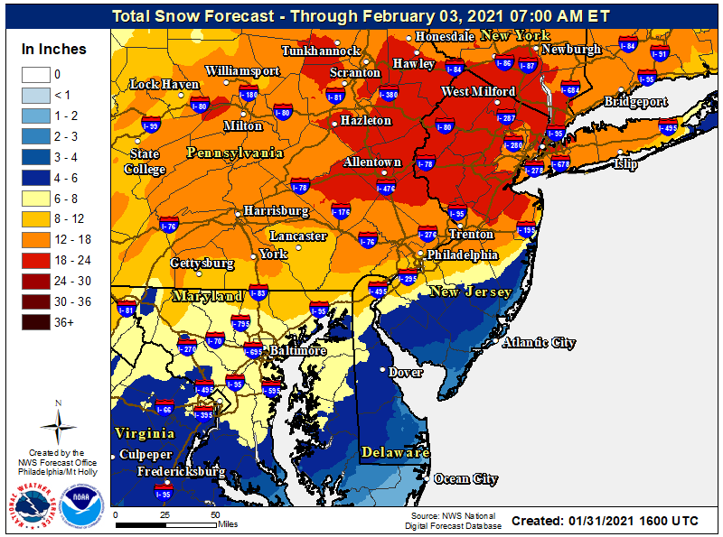
BTW... accurate snow totals are vital for snow removal pricing. Three inch discrepancy could mean a difference of charging more $$$$$. So yea if big difference in saying you got 15 and another says 12.
Yeah. Bravo to some of the Montgomery plow idiots who took out many mailboxes (and a street sign) on my street as they couldn’t bother to be more caferful and slow down a bit as they plowed.Roads have been excellent in Hillsborough/Belle Mead area since 10am yeaterday. Thats truth not something some troll like you is making up. We are just speaking for our area. Bravo to the workers in Montgomery and Hillsborough for being on top of this storm. Thank you Weatherworks
Meanwhile Rock makes a good point..vaccinations and testing were cancelled
I think it is mostly hype. Was reading on AmericanWx this morning that some models have it missing to the south. Maybe just some rain here. It is still early yet thoughAnother storm brewing for super bowl Sunday?
Put up reflectors, they work.Yeah. Bravo to some of the Montgomery plow idiots who took out many mailboxes (and a street sign) on my street as they couldn’t bother to be more caferful and slow down a bit as they plowed.
Spike strips would probably be effective also, along with the threat of large bore projectile weapons.Put up reflectors, they work.
Thank god !haha looks like Sunday is DOA, I am old enough to remember someone here mentioning 6-12 Euro totals for Sunday less than 24 hours ago
BOOM! +1Roads have been excellent in Hillsborough/Belle Mead area since 10am yeaterday. Thats truth not something some troll like you is making up. We are just speaking for our area. Bravo to the workers in Montgomery and Hillsborough for being on top of this storm. Thank you Weatherworks
Meanwhile Rock makes a good point..vaccinations and testing were cancelled
Another +1Who said it was a bust. You are a liar as usual.
Why is it still snowing lightly for last 2 hours in Hills/Mont. Annoying they are even sanding again.
Another +1
The storm wasn't a bust, the bust was the asinine forecast being pushed on this board by some folks.
Yeah. Bravo to some of the Montgomery plow idiots who took out many mailboxes (and a street sign) on my street as they couldn’t bother to be more caferful and slow down a bit as they plowed.
What decade are you in.?I haven't seen sanding since the 70's.
They still cindered/gravelled here in our town up to a few years ago. They would have come around with a street sweeper/cleaner after the snow melted to clean up all of the gravel off the edges of the road.What decade are you in.?I haven't seen sanding since the 70's.
Not saying we don't want snow. Don't want to hear folks rooting for 2 feet of snow one day and then complaining vaccines aren't being distributed. Name calling. Violation of rules.
Another +1
The storm wasn't a bust, the bust was the asinine forecast being pushed on this board by some folks.
You do realize that if the storm didn't do a drunken 15-25 mile wobble west while it was stalled CNJ (especially Somerset county) wouldn't have changed to sleet/ZR and we likely wouldve made a run to 24-34 inches. It really was that close. I weighed in at 19" here in Raritan, 10 miles north and west got 30+, 10 miles south and east got less than a foot.
We were right on the line but WW is nice because they start with reasonable totals rather than going for the moonshot like Mt Holly usually does.
And we got another 1/2" of very light fluffy snow from late evening through the overnight, so that brings me to 18.0' for this storm. That last 1/2" was gone by 10 am though and I think the storm is finally over after 2 days of major snow and 2 more days of lingering light snow, as the storm stalled.That last band of moderate to heavy snow delivered a 1/2" of snow, so we're up to 17.5" for the storm.

BOOM! +1
Roads have been perfect since yesterday morning. We had a wonderful dinner from Genteel's last night and the little one is back in school. Thank you WeatherWorks for being accurate once again and allowing local DPWs to plan for the snow.
Actually the wobbles and the sleet had very little to do with parts of CNJ missing out on 24"+ - it was more the major deformation bands setting up for hours and hours from E PA up through NW NJ, while many of us got intermittent light snow for hours. I got about 2" from 5 pm Monday to 8 am Tuesday, when many of those locations got 6-10" (or more). Very hard to predict where those bands will hit and there's almost always a dearth of precip to the SE of the major bands, due to subsidence. 6" more and I'm at 24"and it could have done another wobble 25 miles west and we would have had 6 inches
The 20" report I posted above from Hillsborough was from a trained spotter and my guess is you weren't plowing 20" yesterday, because the snowpack had settled a few inches by then, but that's "snow depth" not "snow fall" so both can be right.we were in Hillsborough plowing and I can tell you we didnt encounter 20 inches.
everywhere we went yesterday was in the 12-16 range
we already have report from trained spotters yesterday morning from that area
you always are going to find varied storm reports especially with such a difficult storm to measure,
your continued bickering with T2k and then crying about it is a lesson you need in selfawareness and that is why you get blow back...i saw you trolling on 33andrain or americanwx for rocky hill/skillman reports..why? so you can try and prove T2k wrong.
very odd, everyone just needs to own their behavior, I will admit I am troll here at times, t2k is, and so is Numbers
You guys get flooded if I fart in the right direction. 😁We had little snow here (4-5"?) but did have strong winds and flooding. I was outside yesterday watching CBS do a report about the flooding a block or two way from me. This is from the Asbury Park press....
Brielle Road in Manasquan flooded (app.com)
Can you explain why snowfall amount and snow depth are different?The 20" report I posted above from Hillsborough was from a trained spotter and my guess is you weren't plowing 20" yesterday, because the snowpack had settled a few inches by then, but that's "snow depth" not "snow fall" so both can be right.
And you're simply wrong and a bit out of line on my question on snowfall in the Skilman area on the weather board, as my wife's father who died 2 years ago lived in a retirement community in Skilman, as does a very good elderly friend of his, who we became friends with over the years on our many visits there, too, and he knows I'm a bit of a weather nut, but isn't able to get out and measure, so he called my wife to ask me how much they got. Hence my request on the weather boards for that. Never did get an answer and don't need that piece of data to prove T wrong - already have - that's like shooting fish in a barrel.
complete layman here, but my guess is that the board method allows meteorologists to better calculate the QPF so that data can be fed into future forecasts to come up with more accurate predictions. compaction happens differently depending on all sorts of other factors. it's just a data point.Can you explain why snowfall amount and snow depth are different?
I get that spotters use what you have described as a "board" method, were you add up multiple snowfall measurements throughout a storm, but if that method typically ends up with a number higher than anyone can measure on the ground, then why is it used? What benefit does such a measurement practice serve? IMO it's a bad practice that only serves to inflate observed snow depth totals. Seems like something that was devised by a grop of wishcasters to satisfy their craving for higher snow measurements.
If you cant measure it on the ground then it didn't happen.
One of my top 5 all-time comedies and same for my wife and son - we love that show...
Can you explain why snowfall amount and snow depth are different?
I get that spotters use what you have described as a "board" method, were you add up multiple snowfall measurements throughout a storm, but if that method typically ends up with a number higher than anyone can measure on the ground, then why is it used? What benefit does such a measurement practice serve? IMO it's a bad practice that only serves to inflate observed snow depth totals. Seems like something that was devised by a grop of wishcasters to satisfy their craving for higher snow measurements.
If you cant measure it on the ground then it didn't happen.
It's a great question and if you talk to pros they're not unanimous on this one either. It's mostly what evolution said, i.e., wanting to know exactly how much snow truly fell and accumulated, somewhat ignoring compaction. Compaction varies hugely depending on the snow type and if other precip falls, so it can give a very misleading idea of how much snow actually fell and knowing that is key for calibrating models/forecasts. What the pros/modelers really need more than either of those is total liquid equivalent that falls, which is why I always argue for reporting total snow mass (which would make sleet essentially equivalent to 10:1 ratio snow), as total mass is far more important than depth for shoveling/snow removal/driving (and emergency management), but that's much harder to measure. Using the snowboard method is at least going to get closer to the precip that fell than just measuring on the ground does.complete layman here, but my guess is that the board method allows meteorologists to better calculate the QPF so that data can be fed into future forecasts to come up with more accurate predictions. compaction happens differently depending on all sorts of other factors. it's just a data point.
The 20" report I posted above from Hillsborough was from a trained spotter and my guess is you weren't plowing 20" yesterday, because the snowpack had settled a few inches by then, but that's "snow depth" not "snow fall" so both can be right.
And you're simply wrong and a bit out of line on my question on snowfall in the Skilman area on the weather board, as my wife's father who died 2 years ago lived in a retirement community in Skilman, as does a very good elderly friend of his, who we became friends with over the years on our many visits there, too, and he knows I'm a bit of a weather nut, but isn't able to get out and measure, so he called my wife to ask me how much they got. Hence my request on the weather boards for that. Never did get an answer and don't need that piece of data to prove T wrong - already have - that's like shooting fish in a barrel.
We did not get 20 inches in Hillsborough
What you did wasn't far off from the snowboard method of clearing the snow every 6 hours, so your 19" is probably a decent measurement, unless a lot of snow blew into the depression created by shoveling. Also, as I mentioned in my treatise on snow measurement, I only saw about a 0.5-1.0" difference between snow measured over 2 measurements (I only cleared the board when it started sleeting around 1 pm on Monday, which reduced compaction by the sleet) vs. snow depth measured on the ground as of about 1 am Tuesday. We've had about 1.5" since then for a total of 18.0", but the snow depth as of this afternoon was down to about 14-15", due mostly to compaction and a little melting.I moved a total of 19" off my driveway across three clearings in Hillsborough. If I left it all until the end of the storm, it would have been fewer inches but much much harder to move.
The first 5" the first night was very fluffy and would have certainly compacted a lot had I left it until morning.

